Bridge Statistics for Justice, Illinois (IL)
Condition, Traffic, Stress, Structural Evaluation, Project Costs
- National Bridge Inventory (NBI) Statistics
- 12Number of bridges
- 118ft / 35.6mTotal length
- 542,400Total average daily traffic
- 98,474Total average daily truck traffic
- National Bridge Inventory (NBI) Registered Bridges for Justice
- No street view available for this location
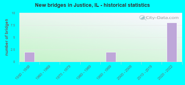
- New bridges - historical statistics
- 21950-1959
- 21990-1999
- 82020-2022


- Bridge Condition - Deck
- 40.0%Excellent
- 40.0%Very good
- 20.0%Satisfactory

- Bridge Condition - Superstructure
- 80.0%Very good
- 20.0%Satisfactory

- Bridge Condition - Substructure
- 80.0%Very good
- 20.0%Fair
Find on map >> Show street view
Structure Number: 160037, Location: 0.3 M E US 45 (Lat: 41.745011, Lng: -87.846553), Route carried "on" structure: State highway 171, Year Built: 2021, Status: Open, Structure Length: 3.48m (11.42ft), Average Daily Traffic: 3,800 (year 2019), Truck Traffic: 7%, Average Future Daily Traffic: 3,800 (year 2043), Design Load: HS 25 or greater, Features Intersected: US 45 SB RMP 2 I294
Minimum Vertical Clearance: 30+ m (98+ ft), Kilometerpoint: 32.814, Lanes on structure: 2, Lanes under structure: 2, Base Highway Network: Yes, Owner: State Highway Agency, Approaching Roadway Width: 11.0m (36.1ft), Skew: 4 degrees, Material/Design: Prestressed concrete, Design/Construction: Stringer/Multi-beam, Number Of Spans In Main Unit: 1, Length of Maximum Span: 32.3m (106.0ft), Curb-To-Curb Width: 11.0m (36.1ft), Out-to-Out Width: 11.8m (38.7ft)
Condition: Deck: Very good, Superstructure: Very good, Substructure: Very good, Operating Rating: 57.0 metric tons, Method Used To Determine Operating Rating: Load and Resistance Factor Rating (LRFR) rating reported by rating factor(RF) method using HL-93 loadings, Inventory Rating: 45.0 metric tons, Method Used To Determine Inventory Rating: Load and Resistance Factor Rating (LRFR) rating reported by rating factor(RF) method using HL-93 loadings, Structural Evaluation: Equal to present desirable criteria, Deck Geometry: Equal to present minimum criteria, Approach Roadway Alignment: Equal to present desirable criteria, Designated Inspection Frequency: Every 24 months, Inspection Date: November 2021, Deck Structure Type: Concrete Cast-file-Place, Wearing Surface/Protective System: Deck Protection: Epoxy Coated Reinforcing
Find on map >> Show street view
Structure Number: 160038, Location: 0.8 M E US 45 (Lat: 41.747278, Lng: -87.841669), Route carried "on" structure: Other road , Year Built: 2021, Status: Open, Structure Length: 2.69m (8.83ft), Average Daily Traffic: 16,200 (year 2018), Truck Traffic: 21%, Average Future Daily Traffic: 16,200 (year 2043), Design Load: HS 25 or greater, Features Intersected: 79TH ST WB, Facility Carried by Structure: IL 171 EB (ARCHER)
Minimum Vertical Clearance: 30+ m (98+ ft), Kilometerpoint: 0.000, Lanes on structure: 2, Lanes under structure: 1, Base Highway Network: Yes, Owner: State Highway Agency, Approaching Roadway Width: 15.2m (49.9ft), Skew: 4 degrees, Material/Design: Prestressed concrete, Design/Construction: Stringer/Multi-beam, Number Of Spans In Main Unit: 1, Length of Maximum Span: 24.0m (78.7ft), Curb-To-Curb Width: 15.2m (49.9ft), Out-to-Out Width: 16.1m (52.8ft)
Condition: Deck: Very good, Superstructure: Very good, Substructure: Very good, Operating Rating: 61.6 metric tons, Method Used To Determine Operating Rating: Load and Resistance Factor Rating (LRFR) rating reported by rating factor(RF) method using HL-93 loadings, Inventory Rating: 48.9 metric tons, Method Used To Determine Inventory Rating: Load and Resistance Factor Rating (LRFR) rating reported by rating factor(RF) method using HL-93 loadings, Structural Evaluation: Equal to present desirable criteria, Deck Geometry: Superior to present desirable criteria, Approach Roadway Alignment: Equal to present desirable criteria, Designated Inspection Frequency: Every 24 months, Inspection Date: November 2021, Deck Structure Type: Concrete Cast-file-Place, Wearing Surface/Protective System: Deck Protection: Epoxy Coated Reinforcing
Find on map >> Show street view
Structure Number: 16187, Location: 0.5 M E of US-12/45 (Lat: 41.746139, Lng: -87.843853), Route carried "on" structure: State highway 171, Year Built: 2021, Status: Open, Structure Length: 9.71m (31.86ft), Average Daily Traffic: 18,300 (year 2021), Truck Traffic: 17%, Average Future Daily Traffic: 17,300 (year 2043), Design Load: HS 25 or greater, Features Intersected: I-294
Minimum Vertical Clearance: 30+ m (98+ ft), Kilometerpoint: 33.135, Lanes on structure: 3, Lanes under structure: 10, Base Highway Network: Yes, Owner: State Highway Agency, Approaching Roadway Width: 14.6m (47.9ft), Skew: 4 degrees, Material/Design: Steel continuous, Design/Construction: Stringer/Multi-beam, Number Of Spans In Main Unit: 2, Length of Maximum Span: 50.6m (166.0ft), Curb-To-Curb Width: 14.3m (46.9ft), Out-to-Out Width: 15.3m (50.2ft)
Condition: Deck: Excellent, Superstructure: Very good, Substructure: Very good, Deck Geometry: Somewhat better than minimum adequacy, Approach Roadway Alignment: Equal to present minimum criteria, Designated Inspection Frequency: Every 12 months, Inspection Date: June 2021, Deck Structure Type: Concrete Cast-file-Place, Wearing Surface/Protective System: Deck Protection: Epoxy Coated Reinforcing
Find on map >> Show street view
Structure Number: 161871, Location: 0.5 M E of US 12/45 (Lat: 41.746872, Lng: -87.844208), Route carried "on" structure: Other road , Year Built: 2021, Status: Open, Structure Length: 11.18m (36.68ft), Average Daily Traffic: 8,100 (year 2018), Truck Traffic: 21%, Average Future Daily Traffic: 7,050 (year 2043), Design Load: HS 25 or greater, Features Intersected: I-294, Facility Carried by Structure: IL 171 WB ARCHER A
Minimum Vertical Clearance: 30+ m (98+ ft), Kilometerpoint: 0.225, Lanes on structure: 3, Lanes under structure: 10, Base Highway Network: Yes, Owner: State Highway Agency, Approaching Roadway Width: 14.6m (47.9ft), Skew: 5 degrees, Material/Design: Steel continuous, Design/Construction: Stringer/Multi-beam, Number Of Spans In Main Unit: 2, Length of Maximum Span: 56.4m (185.0ft), Curb-To-Curb Width: 16.5m (54.1ft), Out-to-Out Width: 17.4m (57.1ft)
Condition: Deck: Excellent, Superstructure: Very good, Substructure: Very good, Deck Geometry: Better than present minimum criteria, Approach Roadway Alignment: Equal to present minimum criteria, Designated Inspection Frequency: Every 12 months, Inspection Date: June 2021, Deck Structure Type: Concrete Cast-file-Place, Wearing Surface/Protective System: Deck Protection: Epoxy Coated Reinforcing
Find on map >> Show street view
Structure Number: 163248, Location: 0.3 MI S IL-171 (Lat: 41.745164, Lng: -87.838489), Route carried "on" structure: Other road , Year Built: 1992, Status: Open, Structure Length: 8.57m (28.12ft), Average Daily Traffic: 10,800 (year 2018), Truck Traffic: 9%, Average Future Daily Traffic: 12,257 (year 2032), Design Load: HS 20, Features Intersected: I-294, Facility Carried by Structure: 88TH AV (CORK)
Minimum Vertical Clearance: 30+ m (98+ ft), Kilometerpoint: 0.370, Lanes on structure: 4, Lanes under structure: 8, Owner: County Highway Agency, Approaching Roadway Width: 18.4m (60.4ft), Skew: 22 degrees, Material/Design: Steel continuous, Design/Construction: Stringer/Multi-beam, Number Of Spans In Main Unit: 2, Number Of Approach Spans: 2, Length of Maximum Span: 45.7m (149.9ft), Curb or Sidewalk Widths: Left: 0.0m, Right: 1.5m (4.9ft), Curb-To-Curb Width: 18.4m (60.4ft), Out-to-Out Width: 20.7m (67.9ft)
Condition: Deck: Satisfactory, Superstructure: Satisfactory, Substructure: Fair, Operating Rating: 74.2 metric tons, Method Used To Determine Operating Rating: Load Factor (LF) rating reported by rating factor (RF) method using MS18 loading, Inventory Rating: 44.4 metric tons, Method Used To Determine Inventory Rating: Load Factor (LF) rating reported by rating factor (RF) method using MS18 loading, Structural Evaluation: Somewhat better than minimum adequacy, Deck Geometry: Somewhat better than minimum adequacy, Underclear: Meets minimum limits, Approach Roadway Alignment: Equal to present desirable criteria, Designated Inspection Frequency: Every 24 months, Inspection Date: May 2020, Deck Structure Type: Concrete Cast-file-Place, Wearing Surface/Protective System: Wearing Surface: Bituminous
Find on map >> Show street view
Structure Number: 160037, Location: 0.3 M E US 45 (Lat: 41.745139, Lng: -87.848025), Route carried "under" structure: Other road , Year Built: 2021, Structure Length: 0. m, Average Daily Traffic: 22,900 (year 2018), Truck Traffic: 18%, Features Intersected: US 45 SB RMP 2 I294, Facility Carried by Structure: IL 171 WB (ARCHER)
Minimum Vertical Clearance: 30+ m (98+ ft), Kilometerpoint: 0.644, Lanes on structure: 2, Lanes under structure: 2, Material/Design: Prestressed concrete, Design/Construction: Stringer/Multi-beam, Length of Maximum Span: 32.3m (106.0ft)
Find on map >> Show street view
Structure Number: 160038, Location: 0.8 M E US 45 (Lat: 41.747278, Lng: -87.841669), Route carried "under" structure: State highway 171, Year Built: 2021, Structure Length: 0. m, Average Daily Traffic: 18,300 (year 2021), Truck Traffic: 17%, Features Intersected: 79TH ST WB
Minimum Vertical Clearance: 30+ m (98+ ft), Kilometerpoint: 33.409, Lanes on structure: 2, Lanes under structure: 1, Material/Design: Prestressed concrete, Design/Construction: Stringer/Multi-beam, Length of Maximum Span: 24.0m (78.7ft)
Find on map >> Show street view
Structure Number: 16187, Location: 0.5 M E of US-12/45 (Lat: 41.746311, Lng: -87.843489), Route carried "under" structure: Interstate 294, Year Built: 2021, Structure Length: 0. m, Average Daily Traffic: 136,100 (year 2020), Truck Traffic: 19%, Features Intersected: I-294, Facility Carried by Structure: IL 171 EB ARCHER A
Minimum Vertical Clearance: 5.59m (18.34ft), Kilometerpoint: 52.334, Lanes on structure: 3, Lanes under structure: 10, Material/Design: Steel continuous, Design/Construction: Stringer/Multi-beam, Length of Maximum Span: 50.6m (166.0ft)
Find on map >> Show street view
Structure Number: 161871, Location: 0.5 M E of US 12/45 (Lat: 41.746564, Lng: -87.845189), Route carried "under" structure: Interstate 294, Year Built: 2021, Structure Length: 0. m, Average Daily Traffic: 129,300 (year 2020), Truck Traffic: 21%, Features Intersected: I-294, Facility Carried by Structure: IL 171 WB ARCHER A
Minimum Vertical Clearance: 6.86m (22.51ft), Kilometerpoint: 52.222, Lanes on structure: 3, Lanes under structure: 10, Material/Design: Steel continuous, Design/Construction: Stringer/Multi-beam, Length of Maximum Span: 56.4m (185.0ft)
Find on map >> Show street view
Structure Number: 163248, Location: 0.3 MI S IL-171 (Lat: 41.744631, Lng: -87.838611), Route carried "under" structure: Interstate 294, Year Built: 1992, Structure Length: 0. m, Average Daily Traffic: 136,100 (year 2020), Truck Traffic: 19%, Features Intersected: I-294, Facility Carried by Structure: 88TH AV (CORK)
Minimum Vertical Clearance: 5.03m (16.50ft), Kilometerpoint: 52.914, Lanes on structure: 4, Lanes under structure: 8, Material/Design: Steel continuous, Design/Construction: Stringer/Multi-beam, Length of Maximum Span: 45.7m (149.9ft)
Find on map >> Show street view
Structure Number: 169824, Location: 1.2 M N US 20 P10 (Lat: 41.733897, Lng: -87.818569), Route carried "under" structure: Other road , Year Built: 1958, Structure Length: 0. m, Average Daily Traffic: 18,400 (year 2018), Truck Traffic: 8%, Features Intersected: ROBERTS RD, Facility Carried by Structure: I-294 NB
Minimum Vertical Clearance: 4.60m (15.09ft), Kilometerpoint: 3.782, Lanes on structure: 3, Lanes under structure: 4, Toll: On toll road, Material/Design: Steel, Design/Construction: Stringer/Multi-beam, Length of Maximum Span: 28.3m (92.8ft)
Find on map >> Show street view
Structure Number: 169827, Location: 1.2 M N US 20 P10 (Lat: 41.733125, Lng: -87.818236), Route carried "under" structure: Other road , Year Built: 1958, Structure Length: 0. m, Average Daily Traffic: 24,100 (year 2018), Truck Traffic: 6%, Features Intersected: 87TH ST, Facility Carried by Structure: I-294 NB
Minimum Vertical Clearance: 4.34m (14.24ft), Kilometerpoint: 2.816, Lanes on structure: 3, Lanes under structure: 2, Toll: On toll road, Material/Design: Steel continuous, Design/Construction: Stringer/Multi-beam, Length of Maximum Span: 29.6m (97.1ft)