Bridge Statistics for Kadoka, South Dakota (SD)
Condition, Traffic, Stress, Structural Evaluation, Project Costs
- National Bridge Inventory (NBI) Statistics
- 10Number of bridges
- 85ft / 25.6mTotal length
- $100,000Total costs
- 21,226Total average daily traffic
- 5,225Total average daily truck traffic
- National Bridge Inventory (NBI) Registered Bridges for Kadoka
- No street view available for this location
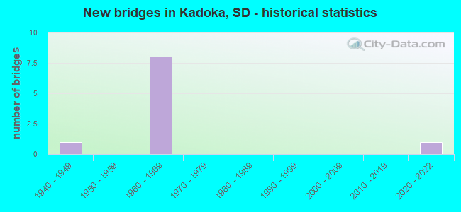
- New bridges - historical statistics
- 11940-1949
- 81960-1969
- 12020-2022


- Bridge Condition - Deck
- 33.3%Good
- 66.7%Satisfactory

- Bridge Condition - Superstructure
- 16.7%Very good
- 33.3%Good
- 50.0%Satisfactory

- Bridge Condition - Substructure
- 50.0%Satisfactory
- 33.3%Fair
- 16.7%Poor

- Bridge Condition - Channel
- 25.0%Very good
- 50.0%Satisfactory
- 25.0%Fair
Find on map >> Show street view
Structure Number: 36290076, Location: 2W & 3.4N KADOKA (Lat: 43.886256, Lng: -101.562022), Route carried "on" structure: County highway , Year Built: 1940, Status: Posted for load, Structure Length: 1.22m (4.00ft), Average Daily Traffic: 30 (year 2019), Truck Traffic: 2%, Average Future Daily Traffic: 30 (year 2032), Features Intersected: FRANKLIN CK, Facility Carried by Structure: 227 AVENUE
Minimum Vertical Clearance: 30+ m (98+ ft), Kilometerpoint: 0.000, Lanes on structure: 1, Owner: County Highway Agency, Approaching Roadway Width: 4.9m (16.1ft), Material/Design: Wood or Timber, Design/Construction: Stringer/Multi-beam, Number Of Spans In Main Unit: 2, Length of Maximum Span: 7.0m (23.0ft), Curb-To-Curb Width: 4.3m (14.1ft), Out-to-Out Width: 4.9m (16.1ft)
Condition: Deck: Satisfactory, Superstructure: Satisfactory, Substructure: Poor, Channel: Fair, Operating Rating: 7.9 metric tons, Method Used To Determine Operating Rating: Allowable Stress (AS), Inventory Rating: 5.0 metric tons, Method Used To Determine Inventory Rating: Allowable Stress (AS), Structural Evaluation: High priority of replacement, Deck Geometry: Equal to present minimum criteria, Waterway Adequacy: Somewhat better than minimum adequacy, Approach Roadway Alignment: Somewhat better than minimum adequacy, Bridge Posting: Required (Relationship of Operating Rating to Maximum Legal Load: > 39.9% below), Length Of Structure Improvement: 1.52m (4.99ft), Designated Inspection Frequency: Every 24 months, Inspection Date: September 2021, Bridge Improvement Cost: $85,000, Roadway Improvement Cost: $15,000, Total Project Cost: $100,000, Deck Structure Type: Wood or Timber, Wearing Surface/Protective System: Wearing Surface: Wood or Timber
Find on map >> Show street view
Structure Number: 3629511, Location: 1.3 W KADOKA INTERCH (Lat: 43.836278, Lng: -101.552019), Route carried "on" structure: Interstate 90, Year Built: 1967, Status: Open, Structure Length: 4.08m (13.39ft), Average Daily Traffic: 3,215 (year 2021), Truck Traffic: 23%, Average Future Daily Traffic: 4,520 (year 2041), Design Load: HS 20+Mod, Features Intersected: WHITE WILLOW CK
Minimum Vertical Clearance: 30+ m (98+ ft), Kilometerpoint: 239.374, Lanes on structure: 2, Base Highway Network: Yes, Owner: State Highway Agency, Approaching Roadway Width: 11.6m (38.1ft), Material/Design: Concrete continuous, Design/Construction: Slab, Number Of Spans In Main Unit: 3, Length of Maximum Span: 14.9m (48.9ft), Curb-To-Curb Width: 11.6m (38.1ft), Out-to-Out Width: 12.4m (40.7ft)
Condition: Deck: Good, Superstructure: Good, Substructure: Satisfactory, Channel: Satisfactory, Operating Rating: 59.2 metric tons, Method Used To Determine Operating Rating: Load Factor (LF), Inventory Rating: 35.4 metric tons, Method Used To Determine Inventory Rating: Load Factor (LF), Structural Evaluation: Equal to present minimum criteria, Deck Geometry: Equal to present minimum criteria, Waterway Adequacy: Superior to present desirable criteria, Approach Roadway Alignment: Equal to present desirable criteria, Designated Inspection Frequency: Every 24 months, Inspection Date: April 2021, Deck Structure Type: Concrete Cast-file-Place, Wearing Surface/Protective System: Wearing Surface: Epoxy Overlay, Membrane: Epoxy
Find on map >> Show street view
Structure Number: 36295111, Location: 1.3 W KADOKA INTERCH (Lat: 43.835983, Lng: -101.551975), Route carried "on" structure: Interstate 90, Year Built: 1967, Status: Open, Structure Length: 4.08m (13.39ft), Average Daily Traffic: 3,215 (year 2021), Truck Traffic: 23%, Average Future Daily Traffic: 4,520 (year 2041), Design Load: HS 20+Mod, Features Intersected: WHITE WILLOW CK
Minimum Vertical Clearance: 30+ m (98+ ft), Kilometerpoint: 239.374, Lanes on structure: 2, Base Highway Network: Yes, Owner: State Highway Agency, Approaching Roadway Width: 11.6m (38.1ft), Material/Design: Concrete continuous, Design/Construction: Slab, Number Of Spans In Main Unit: 3, Length of Maximum Span: 14.9m (48.9ft), Curb-To-Curb Width: 11.6m (38.1ft), Out-to-Out Width: 12.4m (40.7ft)
Condition: Deck: Good, Superstructure: Good, Substructure: Satisfactory, Channel: Satisfactory, Operating Rating: 58.9 metric tons, Method Used To Determine Operating Rating: Load Factor (LF), Inventory Rating: 35.3 metric tons, Method Used To Determine Inventory Rating: Load Factor (LF), Structural Evaluation: Equal to present minimum criteria, Deck Geometry: Equal to present minimum criteria, Waterway Adequacy: Superior to present desirable criteria, Approach Roadway Alignment: Equal to present desirable criteria, Designated Inspection Frequency: Every 24 months, Inspection Date: April 2021, Deck Structure Type: Concrete Cast-file-Place, Wearing Surface/Protective System: Wearing Surface: Epoxy Overlay, Membrane: Epoxy
Find on map >> Show street view
Structure Number: 36296111, Location: 1.4 W OF KADOKA (Lat: 43.835528, Lng: -101.551972), Route carried "on" structure: State highway 248, Year Built: 2020, Status: Open, Structure Length: 1.21m (3.97ft), Average Daily Traffic: 207 (year 2021), Truck Traffic: 5%, Average Future Daily Traffic: 298 (year 2041), Design Load: HL 93, Features Intersected: WHITE WILLOW CK
Minimum Vertical Clearance: 30+ m (98+ ft), Kilometerpoint: 259.040, Lanes on structure: 2, Owner: State Highway Agency, Approaching Roadway Width: 8.5m (27.9ft), Material/Design: Concrete, Design/Construction: Culvert, Number Of Spans In Main Unit: 3, Length of Maximum Span: 3.7m (12.1ft), Out-to-Out Width: 8.5m (27.9ft)
Condition: Channel: Very good, Culverts: Very good, Operating Rating: 95.1 metric tons, Method Used To Determine Operating Rating: Load and Resistance Factor (LRFR), Inventory Rating: 73.4 metric tons, Method Used To Determine Inventory Rating: Load and Resistance Factor (LRFR), Structural Evaluation: Equal to present desirable criteria, Waterway Adequacy: Superior to present desirable criteria, Approach Roadway Alignment: Equal to present desirable criteria, Designated Inspection Frequency: Every 24 months, Inspection Date: December 2020
Find on map >> Show street view
Structure Number: 36309106, Location: SD 73 S INTERCHANGE (Lat: 43.841211, Lng: -101.524539), Route carried "on" structure: State highway 73, Year Built: 1966, Status: Open, Structure Length: 7.74m (25.39ft), Average Daily Traffic: 1,123 (year 2021), Truck Traffic: 14%, Average Future Daily Traffic: 1,619 (year 2041), Design Load: HS 20, Features Intersected: I090
Minimum Vertical Clearance: 30+ m (98+ ft), Kilometerpoint: 114.746, Lanes on structure: 2, Lanes under structure: 4, Owner: State Highway Agency, Approaching Roadway Width: 9.1m (29.9ft), Material/Design: Prestressed concrete continuous, Design/Construction: Stringer/Multi-beam, Number Of Spans In Main Unit: 4, Length of Maximum Span: 21.3m (69.9ft), Curb-To-Curb Width: 9.1m (29.9ft), Out-to-Out Width: 9.8m (32.2ft)
Condition: Deck: Satisfactory, Superstructure: Very good, Substructure: Satisfactory, Operating Rating: 75.3 metric tons, Method Used To Determine Operating Rating: Load Factor (LF), Inventory Rating: 44.5 metric tons, Method Used To Determine Inventory Rating: Load Factor (LF), Structural Evaluation: Equal to present minimum criteria, Deck Geometry: Somewhat better than minimum adequacy, Underclear: Somewhat better than minimum adequacy, Approach Roadway Alignment: Equal to present minimum criteria, Designated Inspection Frequency: Every 24 months, Inspection Date: Febuary 2021, Deck Structure Type: Concrete Cast-file-Place, Wearing Surface/Protective System: Wearing Surface: Epoxy Overlay, Membrane: Epoxy
Find on map >> Show street view
Structure Number: 363301, Location: 2.2 E SD 73 S INTERCHANGE (Lat: 43.851011, Lng: -101.482350), Route carried "on" structure: Interstate 90, Year Built: 1968, Status: Open, Structure Length: 3.63m (11.91ft), Average Daily Traffic: 3,130 (year 2021), Truck Traffic: 30%, Average Future Daily Traffic: 4,401 (year 2041), Design Load: HS 20+Mod, Features Intersected: SD248 P
Minimum Vertical Clearance: 30+ m (98+ ft), Kilometerpoint: 245.296, Lanes on structure: 2, Lanes under structure: 2, Base Highway Network: Yes, Owner: State Highway Agency, Approaching Roadway Width: 11.6m (38.1ft), Material/Design: Concrete continuous, Design/Construction: Slab, Number Of Spans In Main Unit: 3, Length of Maximum Span: 13.1m (43.0ft), Curb-To-Curb Width: 11.6m (38.1ft), Out-to-Out Width: 12.4m (40.7ft)
Condition: Deck: Satisfactory, Superstructure: Satisfactory, Substructure: Fair, Operating Rating: 48.4 metric tons, Method Used To Determine Operating Rating: Load Factor (LF), Inventory Rating: 28.9 metric tons, Method Used To Determine Inventory Rating: Load Factor (LF), Structural Evaluation: Somewhat better than minimum adequacy, Deck Geometry: Equal to present minimum criteria, Underclear: Somewhat better than minimum adequacy, Approach Roadway Alignment: Equal to present desirable criteria, Designated Inspection Frequency: Every 24 months, Inspection Date: April 2021, Deck Structure Type: Concrete Cast-file-Place, Wearing Surface/Protective System: Wearing Surface: Low Slump Concrete, Membrane: Epoxy
Find on map >> Show street view
Structure Number: 36330101, Location: 2.2 E SD 73 S INTERCHANGE (Lat: 43.850789, Lng: -101.482347), Route carried "on" structure: Interstate 90, Year Built: 1968, Status: Open, Structure Length: 3.63m (11.91ft), Average Daily Traffic: 3,130 (year 2021), Truck Traffic: 30%, Average Future Daily Traffic: 4,401 (year 2041), Design Load: HS 20+Mod, Features Intersected: SD248 P
Minimum Vertical Clearance: 30+ m (98+ ft), Kilometerpoint: 245.296, Lanes on structure: 2, Lanes under structure: 2, Base Highway Network: Yes, Owner: State Highway Agency, Approaching Roadway Width: 11.6m (38.1ft), Material/Design: Concrete continuous, Design/Construction: Slab, Number Of Spans In Main Unit: 3, Length of Maximum Span: 13.1m (43.0ft), Curb-To-Curb Width: 11.6m (38.1ft), Out-to-Out Width: 12.4m (40.7ft)
Condition: Deck: Satisfactory, Superstructure: Satisfactory, Substructure: Fair, Operating Rating: 48.4 metric tons, Method Used To Determine Operating Rating: Load Factor (LF), Inventory Rating: 28.9 metric tons, Method Used To Determine Inventory Rating: Load Factor (LF), Structural Evaluation: Somewhat better than minimum adequacy, Deck Geometry: Equal to present minimum criteria, Underclear: Somewhat better than minimum adequacy, Approach Roadway Alignment: Equal to present desirable criteria, Designated Inspection Frequency: Every 24 months, Inspection Date: April 2021, Deck Structure Type: Concrete Cast-file-Place, Wearing Surface/Protective System: Wearing Surface: Epoxy Overlay, Membrane: Epoxy
Find on map >> Show street view
Structure Number: 36309106, Location: SD 73 S INTERCHANGE (Lat: 43.841211, Lng: -101.524539), Route carried "under" structure: Interstate 90, Year Built: 1966, Structure Length: 0. m, Average Daily Traffic: 6,520 (year 2020), Truck Traffic: 25%, Features Intersected: I090, Facility Carried by Structure: SD073
Minimum Vertical Clearance: 5.11m (16.77ft), Kilometerpoint: 241.723, Lanes on structure: 2, Lanes under structure: 4, Material/Design: Prestressed concrete continuous, Design/Construction: Stringer/Multi-beam, Length of Maximum Span: 21.3m (69.9ft)
Find on map >> Show street view
Structure Number: 363301, Location: 2.2 E SD 73 S INTERCHANGE (Lat: 43.851011, Lng: -101.482350), Route carried "under" structure: Spur State highway 248, Year Built: 1968, Structure Length: 0. m, Average Daily Traffic: 328 (year 2021), Truck Traffic: 11%, Features Intersected: SD248 P, Facility Carried by Structure: I090 W
Minimum Vertical Clearance: 4.69m (15.39ft), Kilometerpoint: 265.252, Lanes on structure: 2, Lanes under structure: 2, Material/Design: Concrete continuous, Design/Construction: Slab, Length of Maximum Span: 13.1m (43.0ft)
Find on map >> Show street view
Structure Number: 36330101, Location: 2.2 E SD 73 S INTERCHANGE (Lat: 43.850789, Lng: -101.482347), Route carried "under" structure: Spur State highway 248, Year Built: 1968, Structure Length: 0. m, Average Daily Traffic: 328 (year 2021), Truck Traffic: 11%, Features Intersected: SD248 P, Facility Carried by Structure: I090 E
Minimum Vertical Clearance: 4.62m (15.16ft), Kilometerpoint: 265.204, Lanes on structure: 2, Lanes under structure: 2, Material/Design: Concrete continuous, Design/Construction: Slab, Length of Maximum Span: 13.1m (43.0ft)