Bridge Statistics for Kanorado, Kansas (KS)
Condition, Traffic, Stress, Structural Evaluation, Project Costs
- National Bridge Inventory (NBI) Statistics
- 11Number of bridges
- 148ft / 44.9mTotal length
- 36,690Total average daily traffic
- 7,300Total average daily truck traffic
- National Bridge Inventory (NBI) Registered Bridges for Kanorado
- No street view available for this location
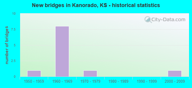
- New bridges - historical statistics
- 11950-1959
- 81960-1969
- 11970-1979
- 12000-2009


- Bridge Condition - Deck
- 87.5%Good
- 12.5%Satisfactory

- Bridge Condition - Superstructure
- 87.5%Good
- 12.5%Satisfactory

- Bridge Condition - Substructure
- 12.5%Very good
- 87.5%Good

- Bridge Condition - Channel
- 33.3%Very good
- 33.3%Good
- 33.3%Satisfactory
Find on map >> Show street view
Structure Number: 91006, Location: 4.0S 17.0W OF GOODLAND (Lat: 39.284622, Lng: -102.023772), Route carried "on" structure: County highway 288, Year Built: 1954, Status: Open, Structure Length: 1.30m (4.27ft), Average Daily Traffic: 140 (year 2014), Truck Traffic: 10%, Average Future Daily Traffic: 150 (year 2040), Design Load: H 15, Features Intersected: TRIB SOUTH BEAVER CREEK
Minimum Vertical Clearance: 30.47m (99.97ft), Kilometerpoint: 0.000, Lanes on structure: 2, Owner: County Highway Agency, Approaching Roadway Width: 8.5m (27.9ft), Material/Design: Concrete, Design/Construction: Culvert, Number Of Spans In Main Unit: 4, Length of Maximum Span: 3.0m (9.8ft), Curb or Sidewalk Widths: Left: 0.3m (1.0ft), Right: 0.3m (1.0ft), Curb-To-Curb Width: 8.5m (27.9ft), Out-to-Out Width: 9.1m (29.9ft)
Condition: Channel: Good, Culverts: Good, Operating Rating: 46.3 metric tons, Method Used To Determine Operating Rating: Load Factor (LF), Inventory Rating: 28.1 metric tons, Method Used To Determine Inventory Rating: Load Factor (LF), Structural Evaluation: Better than present minimum criteria, Deck Geometry: Equal to present minimum criteria, Waterway Adequacy: Equal to present desirable criteria, Approach Roadway Alignment: Equal to present desirable criteria, Designated Inspection Frequency: Every 24 months, Inspection Date: June 2020, Wearing Surface/Protective System: Wearing Surface: Gravel
Find on map >> Show street view
Structure Number: 91007, Location: 1.5S 17.0W OF GOODLAND (Lat: 39.319786, Lng: -102.023436), Route carried "on" structure: County highway 288, Year Built: 1970, Status: Posted for load, Structure Length: 4.83m (15.85ft), Average Daily Traffic: 140 (year 2014), Truck Traffic: 10%, Average Future Daily Traffic: 150 (year 2040), Design Load: H 15, Features Intersected: MIDDLE BEAVER CREEK
Minimum Vertical Clearance: 30.47m (99.97ft), Kilometerpoint: 0.000, Lanes on structure: 2, Owner: County Highway Agency, Approaching Roadway Width: 7.9m (25.9ft), Material/Design: Concrete continuous, Design/Construction: Tee Beam, Number Of Spans In Main Unit: 3, Length of Maximum Span: 18.3m (60.0ft), Curb or Sidewalk Widths: Left: 0.3m (1.0ft), Right: 0.3m (1.0ft), Curb-To-Curb Width: 8.5m (27.9ft), Out-to-Out Width: 9.1m (29.9ft)
Condition: Deck: Good, Superstructure: Good, Substructure: Good, Channel: Satisfactory, Operating Rating: 26.0 metric tons, Method Used To Determine Operating Rating: Load Factor (LF), Inventory Rating: 15.4 metric tons, Method Used To Determine Inventory Rating: Load Factor (LF), Structural Evaluation: Meets minimum limits, Deck Geometry: Equal to present minimum criteria, Waterway Adequacy: Equal to present desirable criteria, Approach Roadway Alignment: Equal to present desirable criteria, Bridge Posting: Required (Relationship of Operating Rating to Maximum Legal Load: 20.0 - 29.9% below), Designated Inspection Frequency: Every 24 months, Inspection Date: June 2020, Other Special Inspection Date: January 2020, Deck Structure Type: Concrete Cast-file-Place, Wearing Surface/Protective System: Wearing Surface: Monolithic Concrete
Find on map >> Show street view
Structure Number: 9101, Location: 15.5W OF GOODLAND (Lat: 39.336211, Lng: -101.993083), Route carried "on" structure: County highway 2000, Year Built: 2004, Status: Open, Structure Length: 4.58m (15.03ft), Average Daily Traffic: 600 (year 2014), Truck Traffic: 10%, Average Future Daily Traffic: 650 (year 2040), Design Load: HS 20, Features Intersected: MIDDLE FORK BEAVER CREEK, Facility Carried by Structure: 140 ROAD
Minimum Vertical Clearance: 30.47m (99.97ft), Kilometerpoint: 0.000, Lanes on structure: 2, Owner: County Highway Agency, Approaching Roadway Width: 8.5m (27.9ft), Material/Design: Concrete continuous, Design/Construction: Slab, Number Of Spans In Main Unit: 3, Length of Maximum Span: 18.0m (59.1ft), Curb-To-Curb Width: 9.2m (30.2ft), Out-to-Out Width: 9.8m (32.2ft)
Condition: Deck: Good, Superstructure: Good, Substructure: Very good, Channel: Satisfactory, Operating Rating: 78.2 metric tons, Method Used To Determine Operating Rating: Load Factor (LF), Inventory Rating: 46.8 metric tons, Method Used To Determine Inventory Rating: Load Factor (LF), Structural Evaluation: Better than present minimum criteria, Deck Geometry: Equal to present minimum criteria, Waterway Adequacy: Equal to present desirable criteria, Approach Roadway Alignment: Equal to present desirable criteria, Designated Inspection Frequency: Every 24 months, Inspection Date: June 2020, Deck Structure Type: Concrete Cast-file-Place, Wearing Surface/Protective System: Wearing Surface: Monolithic Concrete
Find on map >> Show street view
Structure Number: 91011, Location: 15.0W OF GOODLAND (Lat: 39.337878, Lng: -101.986122), Route carried "on" structure: County highway 877, Year Built: 1965, Status: Posted for load, Structure Length: 2.89m (9.48ft), Average Daily Traffic: 245 (year 2014), Truck Traffic: 10%, Average Future Daily Traffic: 300 (year 2040), Design Load: H 15, Features Intersected: MIDDLE FORK BEAVER CREEK
Minimum Vertical Clearance: 30.47m (99.97ft), Kilometerpoint: 0.000, Lanes on structure: 2, Owner: County Highway Agency, Approaching Roadway Width: 7.9m (25.9ft), Material/Design: Steel continuous, Design/Construction: Stringer/Multi-beam, Number Of Spans In Main Unit: 3, Length of Maximum Span: 11.4m (37.4ft), Curb-To-Curb Width: 8.3m (27.2ft), Out-to-Out Width: 8.3m (27.2ft)
Condition: Deck: Satisfactory, Superstructure: Satisfactory, Substructure: Good, Channel: Good, Operating Rating: 24.6 metric tons, Method Used To Determine Operating Rating: Load Factor (LF), Inventory Rating: 14.7 metric tons, Method Used To Determine Inventory Rating: Load Factor (LF), Structural Evaluation: Meets minimum limits, Deck Geometry: Somewhat better than minimum adequacy, Waterway Adequacy: Equal to present desirable criteria, Approach Roadway Alignment: Equal to present desirable criteria, Bridge Posting: Required (Relationship of Operating Rating to Maximum Legal Load: 30.0 - 39.9% below), Designated Inspection Frequency: Every 24 months, Inspection Date: June 2020, Other Special Inspection Date: January 2020, Deck Structure Type: Concrete Cast-file-Place, Wearing Surface/Protective System: Wearing Surface: Bituminous
Find on map >> Show street view
Structure Number: 999907000910011, Location: COLORADO STATE LINE (Lat: 39.329444, Lng: -102.048611), Route carried "on" structure: County highway 6, Year Built: 1969, Status: Open, Structure Length: 8.31m (27.26ft), Truck Traffic: 1%, Design Load: H 15, Features Intersected: I-70 HIGHWAY, Facility Carried by Structure: LOCAL ROAD
Minimum Vertical Clearance: 30.47m (99.97ft), Kilometerpoint: 0.867, Lanes on structure: 2, Lanes under structure: 4, Base Highway Network: Yes, Owner: State Highway Agency, Approaching Roadway Width: 8.5m (27.9ft), Material/Design: Concrete continuous, Design/Construction: Box Beam or Girders - Multiple, Number Of Spans In Main Unit: 4, Length of Maximum Span: 24.1m (79.1ft), Curb-To-Curb Width: 7.3m (24.0ft), Out-to-Out Width: 8.1m (26.6ft)
Condition: Deck: Good, Superstructure: Good, Substructure: Good, Operating Rating: 60.8 metric tons, Method Used To Determine Operating Rating: Load Factor (LF), Inventory Rating: 36.4 metric tons, Method Used To Determine Inventory Rating: Load Factor (LF), Structural Evaluation: Better than present minimum criteria, Deck Geometry: Equal to present minimum criteria, Underclear: Equal to present minimum criteria, Approach Roadway Alignment: Somewhat better than minimum adequacy, Length Of Structure Improvement: 27.25m (89.40ft), Designated Inspection Frequency: Every 24 months, Inspection Date: June 2020, Deck Structure Type: Concrete Cast-file-Place, Wearing Surface/Protective System: Wearing Surface: Monolithic Concrete
Find on map >> Show street view
Structure Number: 999907000910021, Location: 1.35 MI E OF CO STLINE (Lat: 39.329444, Lng: -102.023333), Route carried "on" structure: Interstate 70, Year Built: 1969, Status: Open, Structure Length: 3.73m (12.24ft), Average Daily Traffic: 5,738 (year 2020), Truck Traffic: 21%, Average Future Daily Traffic: 8,198 (year 2041), Design Load: HS 20+Mod, Features Intersected: K-267
Minimum Vertical Clearance: 30.47m (99.97ft), Kilometerpoint: 2.181, Lanes on structure: 2, Lanes under structure: 2, Base Highway Network: Yes, Owner: State Highway Agency, Approaching Roadway Width: 12.2m (40.0ft), Material/Design: Concrete continuous, Design/Construction: Slab, Number Of Spans In Main Unit: 3, Length of Maximum Span: 14.6m (47.9ft), Curb-To-Curb Width: 12.2m (40.0ft), Out-to-Out Width: 12.8m (42.0ft)
Condition: Deck: Good, Superstructure: Good, Substructure: Good, Operating Rating: 59.9 metric tons, Method Used To Determine Operating Rating: Load Factor (LF), Inventory Rating: 36.3 metric tons, Method Used To Determine Inventory Rating: Load Factor (LF), Structural Evaluation: Better than present minimum criteria, Deck Geometry: Better than present minimum criteria, Underclear: Equal to present minimum criteria, Approach Roadway Alignment: Equal to present desirable criteria, Length Of Structure Improvement: 12.25m (40.19ft), Designated Inspection Frequency: Every 24 months, Inspection Date: June 2020, Deck Structure Type: Concrete Cast-file-Place, Wearing Surface/Protective System: Wearing Surface: Low Slump Concrete
Find on map >> Show street view
Structure Number: 999907000910031, Location: 1.36 MI E OF CO STLINE (Lat: 39.329167, Lng: -102.023333), Route carried "on" structure: Interstate 70, Year Built: 1968, Status: Open, Structure Length: 3.73m (12.24ft), Average Daily Traffic: 5,738 (year 2020), Truck Traffic: 21%, Average Future Daily Traffic: 8,198 (year 2041), Design Load: HS 20+Mod, Features Intersected: K-267
Minimum Vertical Clearance: 30.47m (99.97ft), Kilometerpoint: 2.179, Lanes on structure: 2, Lanes under structure: 2, Base Highway Network: Yes, Owner: State Highway Agency, Approaching Roadway Width: 12.2m (40.0ft), Material/Design: Concrete continuous, Design/Construction: Slab, Number Of Spans In Main Unit: 3, Length of Maximum Span: 14.6m (47.9ft), Curb-To-Curb Width: 12.2m (40.0ft), Out-to-Out Width: 12.8m (42.0ft)
Condition: Deck: Good, Superstructure: Good, Substructure: Good, Operating Rating: 59.9 metric tons, Method Used To Determine Operating Rating: Load Factor (LF), Inventory Rating: 36.3 metric tons, Method Used To Determine Inventory Rating: Load Factor (LF), Structural Evaluation: Better than present minimum criteria, Deck Geometry: Better than present minimum criteria, Underclear: Better than present minimum criteria, Approach Roadway Alignment: Equal to present desirable criteria, Length Of Structure Improvement: 12.25m (40.19ft), Designated Inspection Frequency: Every 24 months, Inspection Date: June 2020, Deck Structure Type: Concrete Cast-file-Place, Wearing Surface/Protective System: Wearing Surface: Low Slump Concrete
Find on map >> Show street view
Structure Number: 999907000910041, Location: 1.67 MI E OF CO STLINE (Lat: 39.329167, Lng: -102.017222), Route carried "on" structure: Interstate 70, Year Built: 1969, Status: Open, Structure Length: 7.33m (24.05ft), Average Daily Traffic: 5,738 (year 2020), Truck Traffic: 21%, Average Future Daily Traffic: 8,198 (year 2041), Design Load: HS 20+Mod, Features Intersected: MIDDLE FORK BEAVER CREEK
Minimum Vertical Clearance: 30.47m (99.97ft), Kilometerpoint: 2.694, Lanes on structure: 2, Base Highway Network: Yes, Owner: State Highway Agency, Approaching Roadway Width: 12.2m (40.0ft), Material/Design: Concrete continuous, Design/Construction: Tee Beam, Number Of Spans In Main Unit: 3, Length of Maximum Span: 29.9m (98.1ft), Curb-To-Curb Width: 12.2m (40.0ft), Out-to-Out Width: 12.8m (42.0ft)
Condition: Deck: Good, Superstructure: Good, Substructure: Good, Channel: Very good, Operating Rating: 66.9 metric tons, Method Used To Determine Operating Rating: Load Factor (LF), Inventory Rating: 40.2 metric tons, Method Used To Determine Inventory Rating: Load Factor (LF), Structural Evaluation: Better than present minimum criteria, Deck Geometry: Better than present minimum criteria, Waterway Adequacy: Equal to present desirable criteria, Approach Roadway Alignment: Equal to present desirable criteria, Length Of Structure Improvement: 24.05m (78.90ft), Designated Inspection Frequency: Every 24 months, Inspection Date: June 2020, Deck Structure Type: Concrete Cast-file-Place, Wearing Surface/Protective System: Wearing Surface: Low Slump Concrete
Find on map >> Show street view
Structure Number: 999907000910051, Location: 1.68 MI E OF CO STLINE (Lat: 39.328889, Lng: -102.017222), Route carried "on" structure: Interstate 70, Year Built: 1969, Status: Open, Structure Length: 7.33m (24.05ft), Average Daily Traffic: 5,738 (year 2020), Truck Traffic: 21%, Average Future Daily Traffic: 8,198 (year 2041), Design Load: HS 20+Mod, Features Intersected: MIDDLE FORK BEAVER CREEK
Minimum Vertical Clearance: 30.47m (99.97ft), Kilometerpoint: 2.694, Lanes on structure: 2, Base Highway Network: Yes, Owner: State Highway Agency, Approaching Roadway Width: 12.2m (40.0ft), Material/Design: Concrete continuous, Design/Construction: Tee Beam, Number Of Spans In Main Unit: 3, Length of Maximum Span: 29.9m (98.1ft), Curb-To-Curb Width: 12.2m (40.0ft), Out-to-Out Width: 12.8m (42.0ft)
Condition: Deck: Good, Superstructure: Good, Substructure: Good, Channel: Very good, Operating Rating: 66.9 metric tons, Method Used To Determine Operating Rating: Load Factor (LF), Inventory Rating: 40.2 metric tons, Method Used To Determine Inventory Rating: Load Factor (LF), Structural Evaluation: Better than present minimum criteria, Deck Geometry: Better than present minimum criteria, Waterway Adequacy: Equal to present desirable criteria, Approach Roadway Alignment: Equal to present desirable criteria, Length Of Structure Improvement: 24.05m (78.90ft), Designated Inspection Frequency: Every 24 months, Inspection Date: June 2020, Deck Structure Type: Concrete Cast-file-Place, Wearing Surface/Protective System: Wearing Surface: Low Slump Concrete
Find on map >> Show street view
Structure Number: 999907000910061, Location: 3.36 MI E OF CO STLINE (Lat: 39.328889, Lng: -101.986111), Route carried "on" structure: Interstate 70, Year Built: 1968, Status: Open, Structure Length: 0.85m (2.79ft), Average Daily Traffic: 5,738 (year 2020), Truck Traffic: 21%, Average Future Daily Traffic: 8,198 (year 2041), Design Load: HS 20+Mod, Features Intersected: LOCAL ROAD
Minimum Vertical Clearance: 30.47m (99.97ft), Kilometerpoint: 5.396, Lanes on structure: 4, Lanes under structure: 2, Base Highway Network: Yes, Owner: State Highway Agency, Approaching Roadway Width: 24.4m (80.1ft), Skew: 20 degrees, Material/Design: Concrete, Design/Construction: Culvert, Number Of Spans In Main Unit: 1, Length of Maximum Span: 8.5m (27.9ft), Curb-To-Curb Width: 24.4m (80.1ft), Out-to-Out Width: 48.0m (157.5ft)
Condition: Culverts: Good, Operating Rating: 54.4 metric tons, Method Used To Determine Operating Rating: Load Factor (LF), Inventory Rating: 32.6 metric tons, Method Used To Determine Inventory Rating: Load Factor (LF), Structural Evaluation: Better than present minimum criteria, Deck Geometry: Superior to present desirable criteria, Underclear: High priority of corrective action, Approach Roadway Alignment: Equal to present desirable criteria, Length Of Structure Improvement: 2.80m (9.19ft), Designated Inspection Frequency: Every 24 months, Inspection Date: June 2020, Deck Structure Type: Concrete Cast-file-Place, Wearing Surface/Protective System: Wearing Surface: Monolithic Concrete
Find on map >> Show street view
Structure Number: 999907000910011, Location: COLORADO STATE LINE (Lat: 39.329444, Lng: -102.048611), Route carried "under" structure: Interstate 70, Year Built: 1969, Structure Length: 0. m, Average Daily Traffic: 6,875 (year 2020), Truck Traffic: 17%, Features Intersected: I-70 HIGHWAY, Facility Carried by Structure: LOCAL ROAD
Minimum Vertical Clearance: 5.11m (16.77ft), Kilometerpoint: 0.000, Lanes on structure: 2, Lanes under structure: 4, Material/Design: Concrete continuous, Design/Construction: Box Beam or Girders - Multiple, Length of Maximum Span: 24.1m (79.1ft)