Bridge Statistics for Kaukauna, Wisconsin (WI)
Condition, Traffic, Stress, Structural Evaluation, Project Costs
- National Bridge Inventory (NBI) Statistics
- 24Number of bridges
- 266ft / 80.8mTotal length
- $8,233,000Total costs
- 575,417Total average daily traffic
- 47,286Total average daily truck traffic
- National Bridge Inventory (NBI) Registered Bridges for Kaukauna
- No street view available for this location
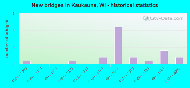
- New bridges - historical statistics
- 11900-1909
- 11930-1939
- 21950-1959
- 111960-1969
- 21970-1979
- 11980-1989
- 41990-1999
- 22000-2009

- Reconstructed bridges - Historical Statistics
- 11970-1979
- 11980-1989
- 01990-1999
- 02000-2009
- 22010-2019


- Bridge Condition - Deck
- 37.5%Good
- 31.3%Satisfactory
- 25.0%Fair
- 6.3%Poor

- Bridge Condition - Superstructure
- 6.3%Excellent
- 12.5%Very good
- 18.8%Good
- 31.3%Satisfactory
- 18.8%Fair
- 12.5%Poor

- Bridge Condition - Substructure
- 18.8%Very good
- 31.3%Good
- 25.0%Satisfactory
- 25.0%Fair

- Bridge Condition - Channel
- 90.0%Very good
- 10.0%Satisfactory
Find on map >> Show street view
Structure Number: B44004, Location: 2.6M S JCT CTH JJ (Lat: 44.299606, Lng: -88.272206), Route carried "on" structure: Interstate 41, Year Built: 1961, Status: Open, Structure Length: 3.64m (11.94ft), Average Daily Traffic: 29,200 (year 2021), Truck Traffic: 10%, Average Future Daily Traffic: 29,025 (year 2040), Design Load: HS 20, Features Intersected: STH 55
Minimum Vertical Clearance: 30+ m (98+ ft), Kilometerpoint: 0.000, Lanes on structure: 2, Lanes under structure: 2, Base Highway Network: Yes, Owner: State Highway Agency, Approaching Roadway Width: 12.2m (40.0ft), Skew: 2 degrees, Material/Design: Concrete continuous, Design/Construction: Slab, Number Of Spans In Main Unit: 3, Length of Maximum Span: 15.1m (49.5ft), Curb-To-Curb Width: 12.3m (40.4ft), Out-to-Out Width: 13.2m (43.3ft)
Condition: Deck: Satisfactory, Superstructure: Satisfactory, Substructure: Very good, Operating Rating: 49.0 metric tons, Method Used To Determine Operating Rating: Load Factor (LF), Inventory Rating: 29.2 metric tons, Method Used To Determine Inventory Rating: Load Factor (LF), Structural Evaluation: Equal to present minimum criteria, Deck Geometry: Better than present minimum criteria, Underclear: High priority of replacement, Approach Roadway Alignment: Equal to present desirable criteria, Length Of Structure Improvement: 4.08m (13.39ft), Designated Inspection Frequency: Every 24 months, Inspection Date: July 2021, Bridge Improvement Cost: $507,000, Roadway Improvement Cost: $50,000, Total Project Cost: $761,000 ( Estimate for 2021), Deck Structure Type: Concrete Cast-file-Place, Wearing Surface/Protective System: Wearing Surface: Low Slump Concrete
Find on map >> Show street view
Structure Number: B440041, Location: 7.3M N JCT STH 47 TO N (Lat: 44.299206, Lng: -88.272297), Route carried "on" structure: Interstate 41, Year Built: 1961, Status: Open, Structure Length: 3.64m (11.94ft), Average Daily Traffic: 292,000 (year 2021), Truck Traffic: 9%, Average Future Daily Traffic: 30,500 (year 2040), Design Load: HS 20, Features Intersected: STH 55
Minimum Vertical Clearance: 30+ m (98+ ft), Kilometerpoint: 0.000, Lanes on structure: 2, Lanes under structure: 2, Base Highway Network: Yes, Owner: State Highway Agency, Approaching Roadway Width: 12.2m (40.0ft), Skew: 2 degrees, Material/Design: Concrete continuous, Design/Construction: Slab, Number Of Spans In Main Unit: 3, Length of Maximum Span: 15.1m (49.5ft), Curb-To-Curb Width: 12.2m (40.0ft), Out-to-Out Width: 13.1m (43.0ft)
Condition: Deck: Satisfactory, Superstructure: Satisfactory, Substructure: Very good, Operating Rating: 58.8 metric tons, Method Used To Determine Operating Rating: Load Factor (LF), Inventory Rating: 34.0 metric tons, Method Used To Determine Inventory Rating: Load Factor (LF), Structural Evaluation: Equal to present minimum criteria, Deck Geometry: Better than present minimum criteria, Underclear: High priority of replacement, Approach Roadway Alignment: Equal to present desirable criteria, Length Of Structure Improvement: 4.08m (13.39ft), Designated Inspection Frequency: Every 24 months, Inspection Date: July 2021, Bridge Improvement Cost: $507,000, Roadway Improvement Cost: $50,000, Total Project Cost: $761,000 ( Estimate for 2021), Deck Structure Type: Concrete Cast-file-Place, Wearing Surface/Protective System: Wearing Surface: Low Slump Concrete
Find on map >> Show street view
Structure Number: B440042, Location: 2.4M S JCT CTH JJ (Lat: 44.301667, Lng: -88.268333), Route carried "on" structure: Interstate 41, Year Built: 1961, Status: Open, Structure Length: 3.38m (11.09ft), Average Daily Traffic: 29,200 (year 2021), Truck Traffic: 16%, Average Future Daily Traffic: 34,400 (year 2040), Design Load: HS 20, Features Intersected: LRD MALONEY RD
Minimum Vertical Clearance: 30+ m (98+ ft), Kilometerpoint: 0.000, Lanes on structure: 2, Lanes under structure: 2, Base Highway Network: Yes, Owner: State Highway Agency, Approaching Roadway Width: 12.2m (40.0ft), Skew: 2 degrees, Material/Design: Concrete continuous, Design/Construction: Slab, Number Of Spans In Main Unit: 3, Length of Maximum Span: 12.8m (42.0ft), Curb-To-Curb Width: 12.3m (40.4ft), Out-to-Out Width: 13.2m (43.3ft)
Condition: Deck: Satisfactory, Superstructure: Satisfactory, Substructure: Satisfactory, Operating Rating: 44.1 metric tons, Method Used To Determine Operating Rating: Load Factor (LF), Inventory Rating: 25.9 metric tons, Method Used To Determine Inventory Rating: Load Factor (LF), Structural Evaluation: Equal to present minimum criteria, Deck Geometry: Better than present minimum criteria, Underclear: Meets minimum limits, Approach Roadway Alignment: Equal to present desirable criteria, Bridge Posting: Required (Relationship of Operating Rating to Maximum Legal Load: 0.1 - 9.9% below), Designated Inspection Frequency: Every 24 months, Inspection Date: July 2021, Deck Structure Type: Concrete Cast-file-Place, Wearing Surface/Protective System: Wearing Surface: Epoxy Overlay
Find on map >> Show street view
Structure Number: B440043, Location: 0.2M N JCT STH 55 TO N (Lat: 44.300000, Lng: -88.268333), Route carried "on" structure: Interstate 41, Year Built: 1961, Status: Open, Structure Length: 3.38m (11.09ft), Average Daily Traffic: 29,200 (year 2021), Truck Traffic: 9%, Average Future Daily Traffic: 30,500 (year 2040), Design Load: HS 20, Features Intersected: LRD MALONEY RD
Minimum Vertical Clearance: 30+ m (98+ ft), Kilometerpoint: 0.000, Lanes on structure: 3, Lanes under structure: 2, Base Highway Network: Yes, Owner: State Highway Agency, Approaching Roadway Width: 12.2m (40.0ft), Skew: 2 degrees, Material/Design: Concrete continuous, Design/Construction: Slab, Number Of Spans In Main Unit: 3, Length of Maximum Span: 12.8m (42.0ft), Curb-To-Curb Width: 16.4m (53.8ft), Out-to-Out Width: 18.3m (60.0ft)
Condition: Deck: Satisfactory, Superstructure: Satisfactory, Substructure: Good, Operating Rating: 37.6 metric tons, Method Used To Determine Operating Rating: Load Factor (LF), Inventory Rating: 22.7 metric tons, Method Used To Determine Inventory Rating: Load Factor (LF), Structural Evaluation: Somewhat better than minimum adequacy, Deck Geometry: Equal to present minimum criteria, Underclear: Somewhat better than minimum adequacy, Approach Roadway Alignment: Equal to present desirable criteria, Bridge Posting: Required (Relationship of Operating Rating to Maximum Legal Load: 0.1 - 9.9% below), Designated Inspection Frequency: Every 24 months, Inspection Date: July 2021, Deck Structure Type: Concrete Cast-file-Place, Wearing Surface/Protective System: Wearing Surface: Low Slump Concrete
Find on map >> Show street view
Structure Number: B440044, Location: 0.7M S JCT CTH JJ (Lat: 44.305258, Lng: -88.249347), Route carried "on" structure: County highway , Year Built: 1961, Year Reconstructed: 2010, Status: Open, Structure Length: 6.59m (21.62ft), Average Daily Traffic: 7,900 (year 2021), Average Future Daily Traffic: 1,023 (year 2040), Design Load: H 20, Features Intersected: IH 41, Facility Carried by Structure: CTH J
Minimum Vertical Clearance: 30+ m (98+ ft), Kilometerpoint: 0.000, Lanes on structure: 2, Lanes under structure: 4, Owner: State Highway Agency, Approaching Roadway Width: 10.4m (34.1ft), Skew: 1 degrees, Material/Design: Prestressed concrete, Design/Construction: Stringer/Multi-beam, Number Of Spans In Main Unit: 4, Length of Maximum Span: 21.5m (70.5ft), Curb-To-Curb Width: 10.4m (34.1ft), Out-to-Out Width: 11.2m (36.7ft)
Condition: Deck: Good, Superstructure: Good, Substructure: Satisfactory, Operating Rating: 60.4 metric tons, Method Used To Determine Operating Rating: Load Factor (LF), Inventory Rating: 22.7 metric tons, Method Used To Determine Inventory Rating: Load Factor (LF), Structural Evaluation: Somewhat better than minimum adequacy, Deck Geometry: Meets minimum limits, Underclear: Somewhat better than minimum adequacy, Approach Roadway Alignment: Equal to present desirable criteria, Designated Inspection Frequency: Every 24 months, Inspection Date: July 2021, Deck Structure Type: Concrete Cast-file-Place, Wearing Surface/Protective System: Wearing Surface: Monolithic Concrete, Deck Protection: Epoxy Coated Reinforcing
Find on map >> Show street view
Structure Number: B440071, Location: 3.2M S JCT CTH U (Lat: 44.314339, Lng: -88.228847), Route carried "on" structure: Interstate 41, Year Built: 2000, Status: Open, Structure Length: 3.03m (9.94ft), Average Daily Traffic: 26,700 (year 2021), Average Future Daily Traffic: 37,000 (year 2040), Design Load: HS 20, Features Intersected: CTH JJ
Minimum Vertical Clearance: 30+ m (98+ ft), Kilometerpoint: 0.000, Lanes on structure: 2, Lanes under structure: 2, Base Highway Network: Yes, Owner: State Highway Agency, Approaching Roadway Width: 11.9m (39.0ft), Skew: 2 degrees, Material/Design: Prestressed concrete, Design/Construction: Stringer/Multi-beam, Number Of Spans In Main Unit: 1, Length of Maximum Span: 29.1m (95.5ft), Curb-To-Curb Width: 12.0m (39.4ft), Out-to-Out Width: 12.8m (42.0ft)
Condition: Deck: Satisfactory, Superstructure: Very good, Substructure: Good, Operating Rating: 70.2 metric tons, Method Used To Determine Operating Rating: Load Factor (LF), Inventory Rating: 35.6 metric tons, Method Used To Determine Inventory Rating: Load Factor (LF), Structural Evaluation: Better than present minimum criteria, Deck Geometry: Equal to present minimum criteria, Underclear: Equal to present minimum criteria, Approach Roadway Alignment: Equal to present desirable criteria, Designated Inspection Frequency: Every 24 months, Inspection Date: July 2021, Deck Structure Type: Concrete Cast-file-Place, Wearing Surface/Protective System: Wearing Surface: Epoxy Overlay, Membrane: Epoxy, Deck Protection: Epoxy Coated Reinforcing
Find on map >> Show street view
Structure Number: B440072, Location: 1.2M N JCT CTH J (Lat: 44.313911, Lng: -88.228772), Route carried "on" structure: Interstate 41, Year Built: 1999, Status: Open, Structure Length: 3.03m (9.94ft), Average Daily Traffic: 26,700 (year 2021), Truck Traffic: 11%, Average Future Daily Traffic: 30,720 (year 2040), Design Load: HS 20, Features Intersected: CTH JJ
Minimum Vertical Clearance: 30+ m (98+ ft), Kilometerpoint: 0.000, Lanes on structure: 2, Lanes under structure: 2, Base Highway Network: Yes, Owner: State Highway Agency, Approaching Roadway Width: 11.9m (39.0ft), Skew: 1 degrees, Material/Design: Prestressed concrete, Design/Construction: Stringer/Multi-beam, Number Of Spans In Main Unit: 1, Length of Maximum Span: 29.1m (95.5ft), Curb-To-Curb Width: 12.0m (39.4ft), Out-to-Out Width: 12.9m (42.3ft)
Condition: Deck: Good, Superstructure: Very good, Substructure: Good, Operating Rating: 70.2 metric tons, Method Used To Determine Operating Rating: Load Factor (LF), Inventory Rating: 35.6 metric tons, Method Used To Determine Inventory Rating: Load Factor (LF), Structural Evaluation: Better than present minimum criteria, Deck Geometry: Equal to present minimum criteria, Underclear: Equal to present minimum criteria, Approach Roadway Alignment: Equal to present desirable criteria, Designated Inspection Frequency: Every 48 months, Inspection Date: July 2021, Deck Structure Type: Concrete Cast-file-Place, Wearing Surface/Protective System: Wearing Surface: Epoxy Overlay, Membrane: Epoxy, Deck Protection: Epoxy Coated Reinforcing
Find on map >> Show street view
Structure Number: B440079, Location: 0.2M E JCT STH 55 (Lat: 44.275511, Lng: -88.267108), Route carried "on" structure: County highway , Year Built: 1978, Status: Open, Structure Length: 2.23m (7.32ft), Average Daily Traffic: 5,842 (year 2019), Average Future Daily Traffic: 6,426 (year 2039), Design Load: HS 20, Features Intersected: KANKAPOT CREEK, Facility Carried by Structure: CTH Z DODGE ST
Minimum Vertical Clearance: 30+ m (98+ ft), Kilometerpoint: 0.000, Lanes on structure: 2, Owner: County Highway Agency, Approaching Roadway Width: 13.4m (44.0ft), Skew: 1 degrees, Material/Design: Prestressed concrete, Design/Construction: Stringer/Multi-beam, Number Of Spans In Main Unit: 1, Length of Maximum Span: 21.7m (71.2ft), Curb or Sidewalk Widths: Left: 2.0m (6.6ft), Right: 2.0m (6.6ft), Curb-To-Curb Width: 13.4m (44.0ft), Out-to-Out Width: 17.7m (58.1ft)
Condition: Deck: Fair, Superstructure: Satisfactory, Substructure: Satisfactory, Channel: Very good, Operating Rating: 62.1 metric tons, Method Used To Determine Operating Rating: Load Factor (LF), Inventory Rating: 34.0 metric tons, Method Used To Determine Inventory Rating: Load Factor (LF), Structural Evaluation: Equal to present minimum criteria, Deck Geometry: Equal to present minimum criteria, Waterway Adequacy: Equal to present desirable criteria, Approach Roadway Alignment: Equal to present desirable criteria, Designated Inspection Frequency: Every 24 months, Inspection Date: October 2020, Deck Structure Type: Concrete Cast-file-Place, Wearing Surface/Protective System: Wearing Surface: Monolithic Concrete
Find on map >> Show street view
Structure Number: B440081, Location: 0.1M E JCT STH 55 (Lat: 44.280867, Lng: -88.266217), Route carried "on" structure: City street , Year Built: 1984, Status: Open, Structure Length: 8.23m (27.00ft), Average Daily Traffic: 6,060 (year 2019), Average Future Daily Traffic: 6,666 (year 2039), Design Load: HS 20, Features Intersected: NAVIGATION CHANNEL, Facility Carried by Structure: LRD WISCONSIN AVE
Minimum Vertical Clearance: 6.61m (21.69ft), Kilometerpoint: 0.000, Lanes on structure: 2, Owner: City or Municipal Highway Agency, Approaching Roadway Width: 11.0m (36.1ft), Navigation Control: Yes ( Vertical Clearance: 18.3m (60.0ft), Horizontal Clearance: 27.4m (89.9ft)), Material/Design: Steel, Design/Construction: Movable - Lift, Number Of Spans In Main Unit: 1, Length of Maximum Span: 39.6m (129.9ft), Curb or Sidewalk Widths: Left: 2.0m (6.6ft), Right: 2.0m (6.6ft), Curb-To-Curb Width: 11.0m (36.1ft), Out-to-Out Width: 14.6m (47.9ft)
Condition: Deck: Good, Superstructure: Fair, Substructure: Satisfactory, Channel: Very good, Operating Rating: 45.7 metric tons, Method Used To Determine Operating Rating: Load Factor (LF), Inventory Rating: 27.5 metric tons, Method Used To Determine Inventory Rating: Load Factor (LF), Structural Evaluation: Somewhat better than minimum adequacy, Deck Geometry: Meets minimum limits, Waterway Adequacy: Equal to present desirable criteria, Approach Roadway Alignment: Equal to present desirable criteria, Designated Inspection Frequency: Every 24 months, Critical Feature Inspection Frequency: Every 24 months, Underwater Inspection Frequency: Every 60 months, Inspection Date: May 2020, Critical Feature Inspection Date: May 2020, Underwater Inspection Date: July 2017, Deck Structure Type: Open Grating, Wearing Surface/Protective System: Wearing Surface: Other
Find on map >> Show street view
Structure Number: B440184, Location: CITY OF KAUKAUNA (Lat: 44.280133, Lng: -88.269267), Route carried "on" structure: State highway 55, Year Built: 1999, Status: Open, Structure Length: 17.30m (56.76ft), Average Daily Traffic: 14,241 (year 2019), Average Future Daily Traffic: 15,665 (year 2039), Design Load: HS 20, Features Intersected: FOX RIVER
Minimum Vertical Clearance: 30+ m (98+ ft), Kilometerpoint: 0.000, Lanes on structure: 4, Owner: City or Municipal Highway Agency, Approaching Roadway Width: 14.3m (46.9ft), Material/Design: Prestressed concrete continuous, Design/Construction: Stringer/Multi-beam, Number Of Spans In Main Unit: 5, Number Of Approach Spans: 1, Length of Maximum Span: 39.2m (128.6ft), Curb or Sidewalk Widths: Left: 2.0m (6.6ft), Right: 2.0m (6.6ft), Curb-To-Curb Width: 14.4m (47.2ft), Out-to-Out Width: 19.0m (62.3ft)
Condition: Deck: Good, Superstructure: Good, Substructure: Good, Channel: Very good, Operating Rating: 58.8 metric tons, Method Used To Determine Operating Rating: Load Factor (LF), Inventory Rating: 34.0 metric tons, Method Used To Determine Inventory Rating: Load Factor (LF), Structural Evaluation: Better than present minimum criteria, Deck Geometry: High priority of replacement, Waterway Adequacy: Equal to present desirable criteria, Approach Roadway Alignment: Equal to present desirable criteria, Length Of Structure Improvement: 17.74m (58.20ft), Designated Inspection Frequency: Every 48 months, Inspection Date: May 2020, Bridge Improvement Cost: $2,830,000, Roadway Improvement Cost: $283,000, Total Project Cost: $4,246,000 ( Estimate for 2021), Deck Structure Type: Concrete Cast-file-Place, Wearing Surface/Protective System: Wearing Surface: Monolithic Concrete, Deck Protection: Epoxy Coated Reinforcing
Find on map >> Show street view
Structure Number: B440185, Location: CITY OF KAUKAUNA (Lat: 44.277783, Lng: -88.270083), Route carried "on" structure: State highway 55, Year Built: 1999, Status: Open, Structure Length: 4.33m (14.21ft), Average Daily Traffic: 11,582 (year 2019), Truck Traffic: 3%, Average Future Daily Traffic: 12,740 (year 2039), Design Load: HS 20, Features Intersected: POWER CANAL
Minimum Vertical Clearance: 30+ m (98+ ft), Kilometerpoint: 0.000, Lanes on structure: 4, Owner: City or Municipal Highway Agency, Approaching Roadway Width: 19.8m (65.0ft), Skew: 3 degrees, Material/Design: Prestressed concrete, Design/Construction: Stringer/Multi-beam, Number Of Spans In Main Unit: 2, Length of Maximum Span: 21.0m (68.9ft), Curb or Sidewalk Widths: Left: 2.0m (6.6ft), Right: 0.0m, Curb-To-Curb Width: 14.4m (47.2ft), Out-to-Out Width: 19.0m (62.3ft)
Condition: Deck: Good, Superstructure: Good, Substructure: Good, Channel: Very good, Operating Rating: 70.2 metric tons, Method Used To Determine Operating Rating: Load Factor (LF), Inventory Rating: 35.6 metric tons, Method Used To Determine Inventory Rating: Load Factor (LF), Structural Evaluation: Better than present minimum criteria, Deck Geometry: High priority of replacement, Waterway Adequacy: Equal to present desirable criteria, Approach Roadway Alignment: Equal to present desirable criteria, Length Of Structure Improvement: 4.79m (15.72ft), Designated Inspection Frequency: Every 48 months, Underwater Inspection Frequency: Every 60 months, Inspection Date: May 2020, Underwater Inspection Date: July 2017, Bridge Improvement Cost: $763,000, Roadway Improvement Cost: $76,000, Total Project Cost: $1,145,000 ( Estimate for 2021), Deck Structure Type: Concrete Cast-file-Place, Wearing Surface/Protective System: Wearing Surface: Monolithic Concrete, Deck Protection: Epoxy Coated Reinforcing
Find on map >> Show street view
Structure Number: P440103, Location: 0.7M S JCT CTH UU (Lat: 44.345950, Lng: -88.241867), Route carried "on" structure: City street , Year Built: 1907, Status: Posted for load, Structure Length: 0.97m (3.18ft), Average Daily Traffic: 94 (year 2019), Average Future Daily Traffic: 103 (year 2040), Design Load: H 15, Features Intersected: BR APPLE CREEK, Facility Carried by Structure: LRD FARRELL RD
Minimum Vertical Clearance: 30+ m (98+ ft), Kilometerpoint: 0.000, Lanes on structure: 2, Owner: Town or Township Highway Agency, Approaching Roadway Width: 6.7m (22.0ft), Material/Design: Masonry, Design/Construction: Arch - Deck, Number Of Spans In Main Unit: 1, Length of Maximum Span: 9.7m (31.8ft), Curb-To-Curb Width: 6.1m (20.0ft), Out-to-Out Width: 6.3m (20.7ft)
Condition: Deck: Poor, Superstructure: Poor, Substructure: Fair, Channel: Very good, Operating Rating: 18.0 metric tons, Method Used To Determine Operating Rating: Load Factor (LF), Inventory Rating: 11.3 metric tons, Method Used To Determine Inventory Rating: Load Factor (LF), Structural Evaluation: Meets minimum limits, Deck Geometry: Somewhat better than minimum adequacy, Waterway Adequacy: Equal to present desirable criteria, Approach Roadway Alignment: Equal to present minimum criteria, Bridge Posting: Required (Relationship of Operating Rating to Maximum Legal Load: 20.0 - 29.9% below), Length Of Structure Improvement: 1.40m (4.59ft), Designated Inspection Frequency: Every 6 months, Inspection Date: September 2021, Bridge Improvement Cost: $109,000, Roadway Improvement Cost: $10,000, Total Project Cost: $164,000 ( Estimate for 2021), Deck Structure Type: Other, Wearing Surface/Protective System: Wearing Surface: Bituminous
Find on map >> Show street view
Structure Number: P440104, Location: 1.0M N JCT CTH JJ (Lat: 44.330500, Lng: -88.241550), Route carried "on" structure: City street , Year Built: 1960, Status: Open, Structure Length: 1.20m (3.94ft), Average Daily Traffic: 94 (year 2019), Average Future Daily Traffic: 103 (year 2040), Design Load: H 15, Features Intersected: APPLE CREEK, Facility Carried by Structure: LRD FARRELL RD
Minimum Vertical Clearance: 30+ m (98+ ft), Kilometerpoint: 0.000, Lanes on structure: 2, Owner: Town or Township Highway Agency, Approaching Roadway Width: 7.3m (24.0ft), Material/Design: Steel, Design/Construction: Culvert, Number Of Spans In Main Unit: 2, Length of Maximum Span: 4.7m (15.4ft)
Condition: Channel: Very good, Culverts: Fair, Operating Rating: 53.9 metric tons, Method Used To Determine Operating Rating: Field evaluation and documented engineering judgment, Inventory Rating: 24.3 metric tons, Method Used To Determine Inventory Rating: Field evaluation and documented engineering judgment, Structural Evaluation: Somewhat better than minimum adequacy, Waterway Adequacy: Equal to present desirable criteria, Approach Roadway Alignment: Equal to present minimum criteria, Designated Inspection Frequency: Every 24 months, Inspection Date: September 2021, Deck Structure Type: Corrugated Steel, Wearing Surface/Protective System: Wearing Surface: Bituminous
Find on map >> Show street view
Structure Number: P440711, Location: 0.4M N JCT CTH Z (Lat: 44.280267, Lng: -88.261317), Route carried "on" structure: City street , Year Built: 1956, Year Reconstructed: 1988, Status: Open, Structure Length: 6.44m (21.13ft), Average Daily Traffic: 1,793 (year 2019), Average Future Daily Traffic: 1,972 (year 2041), Design Load: HS 20, Features Intersected: FOX RIVER, Facility Carried by Structure: LRD ELM ST
Minimum Vertical Clearance: 30+ m (98+ ft), Kilometerpoint: 0.000, Lanes on structure: 2, Owner: City or Municipal Highway Agency, Approaching Roadway Width: 10.1m (33.1ft), Material/Design: Concrete continuous, Design/Construction: Slab, Number Of Spans In Main Unit: 5, Length of Maximum Span: 12.8m (42.0ft), Curb or Sidewalk Widths: Left: 2.0m (6.6ft), Right: 0.0m, Curb-To-Curb Width: 9.1m (29.9ft), Out-to-Out Width: 11.3m (37.1ft)
Condition: Deck: Fair, Superstructure: Fair, Substructure: Fair, Channel: Very good, Operating Rating: 62.1 metric tons, Method Used To Determine Operating Rating: Load Factor (LF), Inventory Rating: 37.3 metric tons, Method Used To Determine Inventory Rating: Load Factor (LF), Structural Evaluation: Somewhat better than minimum adequacy, Deck Geometry: Somewhat better than minimum adequacy, Waterway Adequacy: Equal to present desirable criteria, Approach Roadway Alignment: Equal to present minimum criteria, Designated Inspection Frequency: Every 24 months, Inspection Date: Febuary 2022, Deck Structure Type: Concrete Cast-file-Place, Wearing Surface/Protective System: Wearing Surface: Monolithic Concrete, Deck Protection: Epoxy Coated Reinforcing
Find on map >> Show street view
Structure Number: P440712, Location: 0.1M N JCT CTH Z (Lat: 44.277083, Lng: -88.266600), Route carried "on" structure: City street , Year Built: 1930, Year Reconstructed: 1981, Status: Open, Structure Length: 4.38m (14.37ft), Average Daily Traffic: 6,464 (year 2019), Average Future Daily Traffic: 7,110 (year 2040), Features Intersected: FOX RIVER TAIL RACE, Facility Carried by Structure: LRD ISLAND ST
Minimum Vertical Clearance: 30+ m (98+ ft), Kilometerpoint: 0.000, Lanes on structure: 2, Owner: City or Municipal Highway Agency, Approaching Roadway Width: 13.4m (44.0ft), Skew: 1 degrees, Material/Design: Steel continuous, Design/Construction: Stringer/Multi-beam, Number Of Spans In Main Unit: 3, Length of Maximum Span: 14.3m (46.9ft), Curb or Sidewalk Widths: Left: 0.0m, Right: 2.0m (6.6ft), Curb-To-Curb Width: 6.9m (22.6ft), Out-to-Out Width: 9.6m (31.5ft)
Condition: Deck: Fair, Superstructure: Poor, Substructure: Fair, Channel: Very good, Operating Rating: 35.9 metric tons, Method Used To Determine Operating Rating: Load Factor (LF), Inventory Rating: 17.8 metric tons, Method Used To Determine Inventory Rating: Load Factor (LF), Structural Evaluation: Meets minimum limits, Deck Geometry: High priority of replacement, Waterway Adequacy: Equal to present desirable criteria, Approach Roadway Alignment: Meets minimum limits, Length Of Structure Improvement: 4.82m (15.81ft), Designated Inspection Frequency: Every 12 months, Underwater Inspection Frequency: Every 60 months, Inspection Date: October 2021, Underwater Inspection Date: July 2017, Bridge Improvement Cost: $771,000, Roadway Improvement Cost: $77,000, Total Project Cost: $1,156,000 ( Estimate for 2021), Deck Structure Type: Concrete Cast-file-Place, Wearing Surface/Protective System: Wearing Surface: Monolithic Concrete
Find on map >> Show street view
Structure Number: P440713, Location: 0.3M N JCT CTH Z (Lat: 44.280117, Lng: -88.266133), Route carried "on" structure: City street , Year Built: 1974, Year Reconstructed: 2018, Status: Open, Structure Length: 8.38m (27.49ft), Average Daily Traffic: 7,000 (year 2019), Truck Traffic: 4%, Average Future Daily Traffic: 10,500 (year 2039), Design Load: HS 20, Features Intersected: FOX RIVER, Facility Carried by Structure: LRD ISLAND ST
Minimum Vertical Clearance: 30+ m (98+ ft), Kilometerpoint: 0.000, Lanes on structure: 2, Owner: City or Municipal Highway Agency, Approaching Roadway Width: 11.9m (39.0ft), Skew: 1 degrees, Material/Design: Prestressed concrete continuous, Design/Construction: Stringer/Multi-beam, Number Of Spans In Main Unit: 3, Length of Maximum Span: 28.6m (93.8ft), Curb or Sidewalk Widths: Left: 2.0m (6.6ft), Right: 2.0m (6.6ft), Curb-To-Curb Width: 10.4m (34.1ft), Out-to-Out Width: 14.0m (45.9ft)
Condition: Deck: Good, Superstructure: Excellent, Substructure: Very good, Channel: Very good, Operating Rating: 49.0 metric tons, Method Used To Determine Operating Rating: Load Factor (LF), Inventory Rating: 35.6 metric tons, Method Used To Determine Inventory Rating: Load Factor (LF), Structural Evaluation: Equal to present desirable criteria, Deck Geometry: Meets minimum limits, Waterway Adequacy: Equal to present desirable criteria, Approach Roadway Alignment: Meets minimum limits, Designated Inspection Frequency: Every 24 months, Inspection Date: October 2020, Deck Structure Type: Concrete Cast-file-Place, Wearing Surface/Protective System: Wearing Surface: Monolithic Concrete
Find on map >> Show street view
Structure Number: P440944, Location: 0.3M N JCT CTH JJ (Lat: 44.320275, Lng: -88.252297), Route carried "on" structure: County highway , Year Built: 1950, Status: Open, Structure Length: 0.69m (2.26ft), Average Daily Traffic: 1,947 (year 2019), Average Future Daily Traffic: 2,141 (year 2039), Features Intersected: BR APPLE CREEK, Facility Carried by Structure: CTH J
Minimum Vertical Clearance: 30+ m (98+ ft), Kilometerpoint: 0.000, Lanes on structure: 2, Owner: County Highway Agency, Approaching Roadway Width: 9.8m (32.2ft), Material/Design: Concrete, Design/Construction: Slab, Number Of Spans In Main Unit: 1, Length of Maximum Span: 6.1m (20.0ft), Curb-To-Curb Width: 10.2m (33.5ft), Out-to-Out Width: 10.4m (34.1ft)
Condition: Deck: Fair, Superstructure: Fair, Substructure: Fair, Channel: Satisfactory, Operating Rating: 42.5 metric tons, Method Used To Determine Operating Rating: Load Factor (LF), Inventory Rating: 24.3 metric tons, Method Used To Determine Inventory Rating: Load Factor (LF), Structural Evaluation: Somewhat better than minimum adequacy, Deck Geometry: Somewhat better than minimum adequacy, Waterway Adequacy: Meets minimum limits, Approach Roadway Alignment: Equal to present desirable criteria, Designated Inspection Frequency: Every 24 months, Inspection Date: October 2020, Deck Structure Type: Concrete Cast-file-Place, Wearing Surface/Protective System: Wearing Surface: Bituminous
Find on map >> Show street view
Structure Number: B44004, Location: 0.7M N JCT CTH OO (Lat: 44.299606, Lng: -88.272206), Route carried "under" structure: State highway 55, Year Built: 1961, Structure Length: 0. m, Average Daily Traffic: 10,500 (year 2021), Truck Traffic: 6%, Features Intersected: STH 55, Facility Carried by Structure: IH 41 SB
Minimum Vertical Clearance: 4.65m (15.26ft), Kilometerpoint: 0.000, Lanes on structure: 2, Lanes under structure: 2, Material/Design: Concrete continuous, Design/Construction: Slab, Length of Maximum Span: 15.1m (49.5ft)
Find on map >> Show street view
Structure Number: B440041, Location: 0.6M N JCT CTH OO (Lat: 44.299206, Lng: -88.272297), Route carried "under" structure: State highway 55, Year Built: 1961, Structure Length: 0. m, Average Daily Traffic: 10,500 (year 2021), Truck Traffic: 6%, Features Intersected: STH 55, Facility Carried by Structure: IH 41 NB
Minimum Vertical Clearance: 4.86m (15.94ft), Kilometerpoint: 0.000, Lanes on structure: 2, Lanes under structure: 2, Material/Design: Concrete continuous, Design/Construction: Slab, Length of Maximum Span: 15.1m (49.5ft)
Find on map >> Show street view
Structure Number: B440042, Location: 0.3M E JCT STH 55 (Lat: 44.301667, Lng: -88.268333), Route carried "under" structure: City street , Year Built: 1961, Structure Length: 0. m, Average Daily Traffic: 1,000 (year 2021), Features Intersected: LRD MALONEY RD, Facility Carried by Structure: IH 41 SB
Minimum Vertical Clearance: 4.62m (15.16ft), Kilometerpoint: 0.000, Lanes on structure: 2, Lanes under structure: 2, Material/Design: Concrete continuous, Design/Construction: Slab, Length of Maximum Span: 12.8m (42.0ft)
Find on map >> Show street view
Structure Number: B440043, Location: 0.3M E JCT STH 55 (Lat: 44.300000, Lng: -88.268333), Route carried "under" structure: City street , Year Built: 1961, Structure Length: 0. m, Average Daily Traffic: 1,000 (year 2021), Features Intersected: LRD MALONEY RD, Facility Carried by Structure: IH 41 NB
Minimum Vertical Clearance: 4.55m (14.93ft), Kilometerpoint: 0.000, Lanes on structure: 3, Lanes under structure: 2, Material/Design: Concrete continuous, Design/Construction: Slab, Length of Maximum Span: 12.8m (42.0ft)
Find on map >> Show street view
Structure Number: B440044, Location: 1.3M N JCT STH 55 TO N (Lat: 44.305258, Lng: -88.249347), Route carried "under" structure: Interstate 41, Year Built: 1961, Structure Length: 0. m, Average Daily Traffic: 54,200 (year 2021), Truck Traffic: 11%, Features Intersected: IH 41, Facility Carried by Structure: CTH J
Minimum Vertical Clearance: 4.97m (16.31ft), Kilometerpoint: 0.000, Lanes on structure: 2, Lanes under structure: 4, Material/Design: Prestressed concrete, Design/Construction: Stringer/Multi-beam, Length of Maximum Span: 21.5m (70.5ft)
Find on map >> Show street view
Structure Number: B440071, Location: TOWN OF KAUKAUNA (Lat: 44.314339, Lng: -88.228847), Route carried "under" structure: County highway , Year Built: 2000, Structure Length: 0. m, Average Daily Traffic: 1,100 (year 2021), Features Intersected: CTH JJ, Facility Carried by Structure: IH 41SB
Minimum Vertical Clearance: 4.69m (15.39ft), Kilometerpoint: 0.000, Lanes on structure: 2, Lanes under structure: 2, Material/Design: Prestressed concrete, Design/Construction: Stringer/Multi-beam, Length of Maximum Span: 29.1m (95.5ft)
Find on map >> Show street view
Structure Number: B440072, Location: TOWN OF KAUKAUNA (Lat: 44.313911, Lng: -88.228772), Route carried "under" structure: County highway , Year Built: 1999, Structure Length: 0. m, Average Daily Traffic: 1,100 (year 2021), Features Intersected: CTH JJ, Facility Carried by Structure: IH 41NB
Minimum Vertical Clearance: 4.57m (14.99ft), Kilometerpoint: 0.000, Lanes on structure: 2, Lanes under structure: 2, Material/Design: Prestressed concrete, Design/Construction: Stringer/Multi-beam, Length of Maximum Span: 29.1m (95.5ft)