Bridge Statistics for Kaycee, Wyoming (WY)
Condition, Traffic, Stress, Structural Evaluation, Project Costs
- National Bridge Inventory (NBI) Statistics
- 18Number of bridges
- 207ft / 63.2mTotal length
- 21,082Total average daily traffic
- 9,924Total average daily truck traffic
- National Bridge Inventory (NBI) Registered Bridges for Kaycee
- No street view available for this location
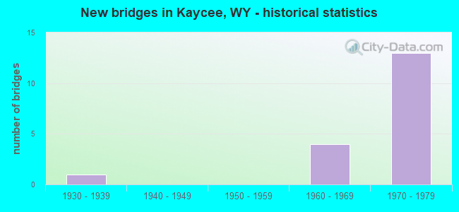
- New bridges - historical statistics
- 11930-1939
- 41960-1969
- 131970-1979
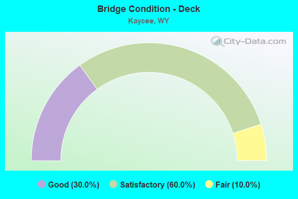
- Bridge Condition - Deck
- 30.0%Good
- 60.0%Satisfactory
- 10.0%Fair
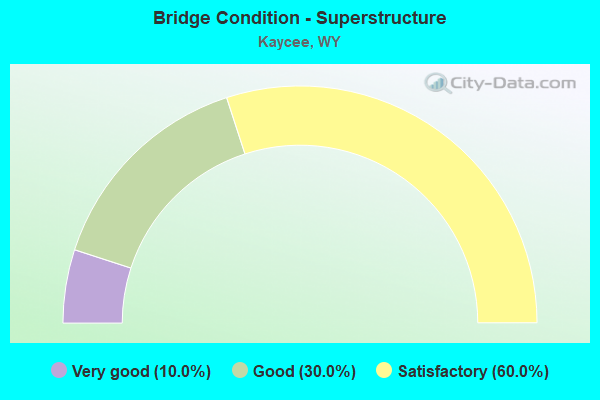
- Bridge Condition - Superstructure
- 10.0%Very good
- 30.0%Good
- 60.0%Satisfactory
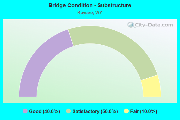
- Bridge Condition - Substructure
- 40.0%Good
- 50.0%Satisfactory
- 10.0%Fair
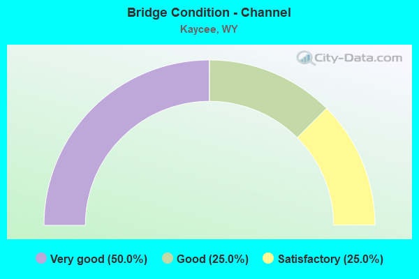
- Bridge Condition - Channel
- 50.0%Very good
- 25.0%Good
- 25.0%Satisfactory
Find on map >> Show street view
Structure Number: AKE, Location: Wyo 387 Jct - Buffalo (Lat: 43.655631, Lng: -106.628228), Route carried "on" structure: Interstate 25, Year Built: 1960, Status: Open, Structure Length: 2.83m (9.28ft), Average Daily Traffic: 1,827 (year 2021), Truck Traffic: 79%, Average Future Daily Traffic: 2,558 (year 2041), Design Load: HS 20+Mod, Features Intersected: TTT Road
Minimum Vertical Clearance: 30.45m (99.90ft), Kilometerpoint: 402.209, Lanes on structure: 2, Lanes under structure: 2, Base Highway Network: Yes (Inventory Route: ML2, Subroute: 2), Owner: State Highway Agency, Approaching Roadway Width: 11.6m (38.1ft), Skew: 10 degrees, Material/Design: Concrete continuous, Design/Construction: Slab, Number Of Spans In Main Unit: 3, Length of Maximum Span: 10.7m (35.1ft), Curb-To-Curb Width: 11.6m (38.1ft), Out-to-Out Width: 12.5m (41.0ft)
Condition: Deck: Satisfactory, Superstructure: Satisfactory, Substructure: Satisfactory, Operating Rating: 56.2 metric tons, Method Used To Determine Operating Rating: Load Factor (LF), Inventory Rating: 33.6 metric tons, Method Used To Determine Inventory Rating: Load Factor (LF), Structural Evaluation: Equal to present minimum criteria, Deck Geometry: Equal to present minimum criteria, Underclear: Meets minimum limits, Approach Roadway Alignment: Equal to present desirable criteria, Designated Inspection Frequency: Every 24 months, Inspection Date: March 2021, Deck Structure Type: Concrete Cast-file-Place, Wearing Surface/Protective System: Wearing Surface: Latex Concrete
Find on map >> Show street view
Structure Number: AKF, Location: Wyo 387 Jct - Buffalo (Lat: 43.655300, Lng: -106.628594), Route carried "on" structure: Interstate 25, Year Built: 1960, Status: Open, Structure Length: 2.83m (9.28ft), Average Daily Traffic: 1,733 (year 2021), Truck Traffic: 20%, Average Future Daily Traffic: 2,426 (year 2041), Design Load: HS 20+Mod, Features Intersected: TTT Road
Minimum Vertical Clearance: 30.45m (99.90ft), Kilometerpoint: 402.198, Lanes on structure: 2, Lanes under structure: 2, Base Highway Network: Yes (Inventory Route: ML2, Subroute: 2), Owner: State Highway Agency, Approaching Roadway Width: 11.6m (38.1ft), Skew: 10 degrees, Material/Design: Concrete continuous, Design/Construction: Slab, Number Of Spans In Main Unit: 3, Length of Maximum Span: 10.7m (35.1ft), Curb-To-Curb Width: 11.6m (38.1ft), Out-to-Out Width: 12.5m (41.0ft)
Condition: Deck: Satisfactory, Superstructure: Satisfactory, Substructure: Satisfactory, Operating Rating: 56.2 metric tons, Method Used To Determine Operating Rating: Load Factor (LF), Inventory Rating: 33.6 metric tons, Method Used To Determine Inventory Rating: Load Factor (LF), Structural Evaluation: Equal to present minimum criteria, Deck Geometry: Equal to present minimum criteria, Underclear: Meets minimum limits, Approach Roadway Alignment: Equal to present desirable criteria, Designated Inspection Frequency: Every 24 months, Inspection Date: March 2021, Deck Structure Type: Concrete Cast-file-Place, Wearing Surface/Protective System: Wearing Surface: Latex Concrete
Find on map >> Show street view
Structure Number: AKG, Location: Midwest - Buffalo (Lat: 43.708117, Lng: -106.646878), Route carried "on" structure: Other road , Year Built: 1971, Status: Open, Structure Length: 9.69m (31.79ft), Average Daily Traffic: 150 (year 2021), Truck Traffic: 2%, Average Future Daily Traffic: 210 (year 2041), Design Load: HS 20+Mod, Features Intersected: I-25, Facility Carried by Structure: Wy Thom Road
Minimum Vertical Clearance: 30+ m (98+ ft), Kilometerpoint: 160.279, Lanes on structure: 2, Lanes under structure: 4, Owner: State Highway Agency, Approaching Roadway Width: 6.7m (22.0ft), Material/Design: Steel continuous, Design/Construction: Stringer/Multi-beam, Number Of Spans In Main Unit: 2, Length of Maximum Span: 47.9m (157.2ft), Curb-To-Curb Width: 9.8m (32.2ft), Out-to-Out Width: 10.6m (34.8ft)
Condition: Deck: Satisfactory, Superstructure: Good, Substructure: Good, Operating Rating: 60.8 metric tons, Method Used To Determine Operating Rating: Load Factor (LF), Inventory Rating: 36.3 metric tons, Method Used To Determine Inventory Rating: Load Factor (LF), Structural Evaluation: Better than present minimum criteria, Deck Geometry: Better than present minimum criteria, Underclear: Equal to present desirable criteria, Approach Roadway Alignment: Equal to present desirable criteria, Designated Inspection Frequency: Every 24 months, Inspection Date: April 2020, Deck Structure Type: Concrete Cast-file-Place
Find on map >> Show street view
Structure Number: AKH, Location: Wyo 387 Jct - Buffalo (Lat: 43.712136, Lng: -106.644019), Route carried "on" structure: Interstate 25, Year Built: 1970, Status: Open, Structure Length: 5.97m (19.59ft), Average Daily Traffic: 1,781 (year 2021), Truck Traffic: 76%, Average Future Daily Traffic: 2,493 (year 2041), Design Load: HS 20+Mod, Features Intersected: M Fork Powder River
Minimum Vertical Clearance: 30+ m (98+ ft), Kilometerpoint: 409.053, Lanes on structure: 2, Base Highway Network: Yes (Inventory Route: ML2, Subroute: 2), Owner: State Highway Agency, Approaching Roadway Width: 12.8m (42.0ft), Skew: 11 degrees, Material/Design: Steel continuous, Design/Construction: Stringer/Multi-beam, Number Of Spans In Main Unit: 3, Length of Maximum Span: 22.9m (75.1ft), Curb-To-Curb Width: 14.6m (47.9ft), Out-to-Out Width: 15.4m (50.5ft)
Condition: Deck: Satisfactory, Superstructure: Good, Substructure: Good, Channel: Very good, Operating Rating: 49.9 metric tons, Method Used To Determine Operating Rating: Load Factor (LF), Inventory Rating: 29.9 metric tons, Method Used To Determine Inventory Rating: Load Factor (LF), Structural Evaluation: Better than present minimum criteria, Deck Geometry: Superior to present desirable criteria, Waterway Adequacy: Equal to present desirable criteria, Approach Roadway Alignment: Equal to present desirable criteria, Designated Inspection Frequency: Every 24 months, Inspection Date: April 2020, Deck Structure Type: Concrete Cast-file-Place
Find on map >> Show street view
Structure Number: AKI, Location: Wyo 387 Jct - Buffalo (Lat: 43.712414, Lng: -106.644511), Route carried "on" structure: Interstate 25, Year Built: 1970, Status: Open, Structure Length: 5.97m (19.59ft), Average Daily Traffic: 1,699 (year 2021), Truck Traffic: 20%, Average Future Daily Traffic: 2,379 (year 2041), Design Load: HS 20+Mod, Features Intersected: M Fork Powder River
Minimum Vertical Clearance: 30+ m (98+ ft), Kilometerpoint: 409.127, Lanes on structure: 2, Base Highway Network: Yes (Inventory Route: ML2, Subroute: 2), Owner: State Highway Agency, Approaching Roadway Width: 12.8m (42.0ft), Skew: 11 degrees, Material/Design: Steel continuous, Design/Construction: Stringer/Multi-beam, Number Of Spans In Main Unit: 3, Length of Maximum Span: 22.9m (75.1ft), Curb-To-Curb Width: 14.6m (47.9ft), Out-to-Out Width: 15.5m (50.9ft)
Condition: Deck: Satisfactory, Superstructure: Good, Substructure: Good, Channel: Very good, Operating Rating: 49.9 metric tons, Method Used To Determine Operating Rating: Load Factor (LF), Inventory Rating: 29.9 metric tons, Method Used To Determine Inventory Rating: Load Factor (LF), Structural Evaluation: Better than present minimum criteria, Deck Geometry: Superior to present desirable criteria, Waterway Adequacy: Equal to present desirable criteria, Approach Roadway Alignment: Equal to present desirable criteria, Designated Inspection Frequency: Every 24 months, Inspection Date: April 2020, Deck Structure Type: Concrete Cast-file-Place
Find on map >> Show street view
Structure Number: AKJ, Location: Wyo 387 Jct - Buffalo (Lat: 43.715686, Lng: -106.641181), Route carried "on" structure: Interstate 25, Year Built: 1970, Status: Open, Structure Length: 5.79m (19.00ft), Average Daily Traffic: 1,781 (year 2021), Truck Traffic: 76%, Average Future Daily Traffic: 2,493 (year 2041), Design Load: HS 20+Mod, Features Intersected: WYO 191
Minimum Vertical Clearance: 30+ m (98+ ft), Kilometerpoint: 409.509, Lanes on structure: 2, Lanes under structure: 2, Base Highway Network: Yes (Inventory Route: ML2, Subroute: 2), Owner: State Highway Agency, Approaching Roadway Width: 12.8m (42.0ft), Skew: 10 degrees, Material/Design: Concrete continuous, Design/Construction: Box Beam or Girders - Multiple, Number Of Spans In Main Unit: 2, Length of Maximum Span: 29.3m (96.1ft), Curb-To-Curb Width: 12.8m (42.0ft), Out-to-Out Width: 13.6m (44.6ft)
Condition: Deck: Good, Superstructure: Satisfactory, Substructure: Satisfactory, Operating Rating: 59.9 metric tons, Method Used To Determine Operating Rating: Load Factor (LF), Inventory Rating: 36.3 metric tons, Method Used To Determine Inventory Rating: Load Factor (LF), Structural Evaluation: Equal to present minimum criteria, Deck Geometry: Equal to present desirable criteria, Underclear: Somewhat better than minimum adequacy, Approach Roadway Alignment: Equal to present desirable criteria, Designated Inspection Frequency: Every 24 months, Inspection Date: May 2020, Deck Structure Type: Concrete Cast-file-Place, Wearing Surface/Protective System: Wearing Surface: Latex Concrete
Find on map >> Show street view
Structure Number: AKK, Location: Wyo 387 Jct - Buffalo (Lat: 43.715864, Lng: -106.641692), Route carried "on" structure: Interstate 25, Year Built: 1970, Status: Open, Structure Length: 5.79m (19.00ft), Average Daily Traffic: 1,699 (year 2021), Truck Traffic: 20%, Average Future Daily Traffic: 2,379 (year 2041), Design Load: HS 20+Mod, Features Intersected: WYO 191
Minimum Vertical Clearance: 30+ m (98+ ft), Kilometerpoint: 409.573, Lanes on structure: 2, Lanes under structure: 2, Base Highway Network: Yes (Inventory Route: ML2, Subroute: 2), Owner: State Highway Agency, Approaching Roadway Width: 12.8m (42.0ft), Skew: 10 degrees, Material/Design: Concrete continuous, Design/Construction: Box Beam or Girders - Multiple, Number Of Spans In Main Unit: 2, Length of Maximum Span: 29.3m (96.1ft), Curb-To-Curb Width: 12.8m (42.0ft), Out-to-Out Width: 13.6m (44.6ft)
Condition: Deck: Good, Superstructure: Satisfactory, Substructure: Fair, Operating Rating: 59.9 metric tons, Method Used To Determine Operating Rating: Load Factor (LF), Inventory Rating: 35.4 metric tons, Method Used To Determine Inventory Rating: Load Factor (LF), Structural Evaluation: Somewhat better than minimum adequacy, Deck Geometry: Equal to present desirable criteria, Underclear: Somewhat better than minimum adequacy, Approach Roadway Alignment: Equal to present desirable criteria, Designated Inspection Frequency: Every 24 months, Inspection Date: May 2020, Deck Structure Type: Concrete Cast-file-Place, Wearing Surface/Protective System: Wearing Surface: Latex Concrete
Find on map >> Show street view
Structure Number: AKL, Location: Midwest - Buffalo (Lat: 43.751811, Lng: -106.623469), Route carried "on" structure: Other road , Year Built: 1971, Status: Open, Structure Length: 10.42m (34.19ft), Average Daily Traffic: 28 (year 2021), Truck Traffic: 2%, Average Future Daily Traffic: 39 (year 2041), Design Load: HS 20+Mod, Features Intersected: I-25, Facility Carried by Structure: N. Fork Road
Minimum Vertical Clearance: 30+ m (98+ ft), Kilometerpoint: 0.378, Lanes on structure: 2, Lanes under structure: 4, Owner: State Highway Agency, Approaching Roadway Width: 9.1m (29.9ft), Material/Design: Steel continuous, Design/Construction: Stringer/Multi-beam, Number Of Spans In Main Unit: 2, Length of Maximum Span: 51.5m (169.0ft), Curb-To-Curb Width: 9.8m (32.2ft), Out-to-Out Width: 10.6m (34.8ft)
Condition: Deck: Satisfactory, Superstructure: Satisfactory, Substructure: Satisfactory, Operating Rating: 70.8 metric tons, Method Used To Determine Operating Rating: Load Factor (LF), Inventory Rating: 41.7 metric tons, Method Used To Determine Inventory Rating: Load Factor (LF), Structural Evaluation: Equal to present minimum criteria, Deck Geometry: Equal to present desirable criteria, Underclear: Somewhat better than minimum adequacy, Approach Roadway Alignment: Equal to present desirable criteria, Designated Inspection Frequency: Every 24 months, Inspection Date: May 2020, Deck Structure Type: Concrete Cast-file-Place
Find on map >> Show street view
Structure Number: COQ, Location: Kaycee - Buffalo (Lat: 43.767614, Lng: -106.610486), Route carried "on" structure: State highway 196, Year Built: 1935, Status: Open, Structure Length: 4.02m (13.19ft), Average Daily Traffic: 302 (year 2021), Truck Traffic: 10%, Average Future Daily Traffic: 423 (year 2041), Design Load: H 15, Features Intersected: North Fork Powder River
Minimum Vertical Clearance: 30+ m (98+ ft), Kilometerpoint: 415.195, Lanes on structure: 2, Owner: State Highway Agency, Approaching Roadway Width: 7.3m (24.0ft), Skew: 2 degrees, Material/Design: Steel, Design/Construction: Stringer/Multi-beam, Number Of Spans In Main Unit: 4, Length of Maximum Span: 12.2m (40.0ft), Curb-To-Curb Width: 7.3m (24.0ft), Out-to-Out Width: 8.2m (26.9ft)
Condition: Deck: Fair, Superstructure: Satisfactory, Substructure: Satisfactory, Channel: Satisfactory, Operating Rating: 38.1 metric tons, Method Used To Determine Operating Rating: Load Factor (LF), Inventory Rating: 22.7 metric tons, Method Used To Determine Inventory Rating: Load Factor (LF), Structural Evaluation: Equal to present minimum criteria, Deck Geometry: Somewhat better than minimum adequacy, Waterway Adequacy: Equal to present desirable criteria, Approach Roadway Alignment: Equal to present desirable criteria, Designated Inspection Frequency: Every 24 months, Inspection Date: March 2021, Deck Structure Type: Concrete Cast-file-Place, Wearing Surface/Protective System: Wearing Surface: Bituminous
Find on map >> Show street view
Structure Number: DCE, Location: Kaycee (Lat: 43.707817, Lng: -106.639144), Route carried "on" structure: State highway 196, Year Built: 1977, Status: Open, Structure Length: 9.88m (32.41ft), Average Daily Traffic: 1,291 (year 2021), Truck Traffic: 10%, Average Future Daily Traffic: 1,807 (year 2041), Design Load: HS 20, Features Intersected: M Fork Powder River
Minimum Vertical Clearance: 30+ m (98+ ft), Kilometerpoint: 408.072, Lanes on structure: 2, Owner: State Highway Agency, Approaching Roadway Width: 11.0m (36.1ft), Material/Design: Steel continuous, Design/Construction: Stringer/Multi-beam, Number Of Spans In Main Unit: 5, Length of Maximum Span: 19.5m (64.0ft), Curb or Sidewalk Widths: Left: 1.5m (4.9ft), Right: 0.0m, Curb-To-Curb Width: 11.0m (36.1ft), Out-to-Out Width: 13.5m (44.3ft)
Condition: Deck: Good, Superstructure: Very good, Substructure: Good, Channel: Good, Operating Rating: 46.7 metric tons, Method Used To Determine Operating Rating: Load Factor (LF), Inventory Rating: 28.1 metric tons, Method Used To Determine Inventory Rating: Load Factor (LF), Structural Evaluation: Better than present minimum criteria, Deck Geometry: Equal to present minimum criteria, Waterway Adequacy: Better than present minimum criteria, Approach Roadway Alignment: Equal to present desirable criteria, Designated Inspection Frequency: Every 24 months, Underwater Inspection Frequency: Every 60 months, Inspection Date: March 2021, Underwater Inspection Date: October 2019, Deck Structure Type: Concrete Cast-file-Place
Find on map >> Show street view
Structure Number: AKE, Location: Wyo 387 Jct - Buffalo (Lat: 43.655631, Lng: -106.628228), Route carried "under" structure: County highway 9173, Year Built: 1960, Structure Length: 0. m, Average Daily Traffic: 118 (year 2021), Truck Traffic: 17%, Features Intersected: TTT Road, Facility Carried by Structure: I-25 NBL
Minimum Vertical Clearance: 4.32m (14.17ft), Kilometerpoint: 161.243, Lanes on structure: 2, Lanes under structure: 2, Material/Design: Concrete continuous, Design/Construction: Slab, Length of Maximum Span: 10.7m (35.1ft)
Find on map >> Show street view
Structure Number: AKF, Location: Wyo 387 Jct - Buffalo (Lat: 43.655300, Lng: -106.628594), Route carried "under" structure: County highway 9173, Year Built: 1960, Structure Length: 0. m, Average Daily Traffic: 118 (year 2021), Truck Traffic: 17%, Features Intersected: TTT Road, Facility Carried by Structure: I-25 SBL
Minimum Vertical Clearance: 4.34m (14.24ft), Kilometerpoint: 161.292, Lanes on structure: 2, Lanes under structure: 2, Material/Design: Concrete continuous, Design/Construction: Slab, Length of Maximum Span: 10.7m (35.1ft)
Find on map >> Show street view
Structure Number: AKG, Location: Midwest - Buffalo (Lat: 43.708117, Lng: -106.646878), Route carried "under" structure: Interstate 25, Year Built: 1971, Structure Length: 0. m, Average Daily Traffic: 1,781 (year 2021), Truck Traffic: 76%, Features Intersected: I-25, Facility Carried by Structure: Wy Thom Road
Minimum Vertical Clearance: 5.49m (18.01ft), Kilometerpoint: 408.582, Lanes on structure: 2, Lanes under structure: 2, Material/Design: Steel continuous, Design/Construction: Stringer/Multi-beam, Length of Maximum Span: 47.9m (157.2ft)
Find on map >> Show street view
Structure Number: AKG, Location: Midwest - Buffalo (Lat: 43.708117, Lng: -106.646878), Route carried "under" structure: Interstate 25, Year Built: 1971, Structure Length: 0. m, Average Daily Traffic: 1,699 (year 2021), Truck Traffic: 20%, Features Intersected: I-25, Facility Carried by Structure: Wy Thom Road
Minimum Vertical Clearance: 5.49m (18.01ft), Kilometerpoint: 408.617, Lanes on structure: 2, Lanes under structure: 2, Material/Design: Steel continuous, Design/Construction: Stringer/Multi-beam, Length of Maximum Span: 47.9m (157.2ft)
Find on map >> Show street view
Structure Number: AKJ, Location: Wyo 387 Jct - Buffalo (Lat: 43.715686, Lng: -106.641181), Route carried "under" structure: State highway 191, Year Built: 1970, Structure Length: 0. m, Average Daily Traffic: 1,033 (year 2021), Truck Traffic: 10%, Features Intersected: WYO 191, Facility Carried by Structure: I-25 NBL
Minimum Vertical Clearance: 5.46m (17.91ft), Kilometerpoint: 0.240, Lanes on structure: 2, Lanes under structure: 2, Material/Design: Concrete continuous, Design/Construction: Box Beam or Girders - Multiple, Length of Maximum Span: 29.3m (96.1ft)
Find on map >> Show street view
Structure Number: AKK, Location: Wyo 387 Jct - Buffalo (Lat: 43.715864, Lng: -106.641692), Route carried "under" structure: State highway 191, Year Built: 1970, Structure Length: 0. m, Average Daily Traffic: 480 (year 2021), Truck Traffic: 10%, Features Intersected: WYO 191, Facility Carried by Structure: I-25 SBL
Minimum Vertical Clearance: 5.46m (17.91ft), Kilometerpoint: 0.286, Lanes on structure: 2, Lanes under structure: 2, Material/Design: Concrete continuous, Design/Construction: Box Beam or Girders - Multiple, Length of Maximum Span: 29.3m (96.1ft)
Find on map >> Show street view
Structure Number: AKL, Location: Midwest - Buffalo (Lat: 43.751811, Lng: -106.623469), Route carried "under" structure: Interstate 25, Year Built: 1971, Structure Length: 0. m, Average Daily Traffic: 1,781 (year 2021), Truck Traffic: 76%, Features Intersected: I-25, Facility Carried by Structure: N. Fork Road
Minimum Vertical Clearance: 5.13m (16.83ft), Kilometerpoint: 413.809, Lanes on structure: 2, Lanes under structure: 2, Material/Design: Steel continuous, Design/Construction: Stringer/Multi-beam, Length of Maximum Span: 51.5m (169.0ft)
Find on map >> Show street view
Structure Number: AKL, Location: Midwest - Buffalo (Lat: 43.751811, Lng: -106.623469), Route carried "under" structure: Interstate 25, Year Built: 1971, Structure Length: 0. m, Average Daily Traffic: 1,781 (year 2021), Truck Traffic: 76%, Features Intersected: I-25, Facility Carried by Structure: N. Fork Road
Minimum Vertical Clearance: 4.95m (16.24ft), Kilometerpoint: 413.891, Lanes on structure: 2, Lanes under structure: 2, Material/Design: Steel continuous, Design/Construction: Stringer/Multi-beam, Length of Maximum Span: 51.5m (169.0ft)