Bridge Statistics for Keenesburg, Colorado (CO)
Condition, Traffic, Stress, Structural Evaluation, Project Costs
- National Bridge Inventory (NBI) Statistics
- 12Number of bridges
- 59ft / 18.0mTotal length
- 46,528Total average daily traffic
- 7,819Total average daily truck traffic
- National Bridge Inventory (NBI) Registered Bridges for Keenesburg
- No street view available for this location
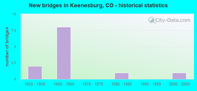
- New bridges - historical statistics
- 21950-1959
- 81960-1969
- 11980-1989
- 12000-2009


- Bridge Condition - Deck
- 25.0%Good
- 37.5%Satisfactory
- 37.5%Fair

- Bridge Condition - Superstructure
- 50.0%Good
- 37.5%Satisfactory
- 12.5%Fair

- Bridge Condition - Substructure
- 12.5%Good
- 75.0%Satisfactory
- 12.5%Fair

- Bridge Condition - Channel
- 50.0%Very good
- 25.0%Good
- 25.0%Satisfactory
Find on map >> Show street view
Structure Number: D-18-A, Location: 5 MI E OF JCT I-76 (Lat: 40.073194, Lng: -104.554814), Route carried "on" structure: State highway 52A, Year Built: 1953, Status: Open, Structure Length: 1.42m (4.66ft), Average Daily Traffic: 2,900 (year 2020), Truck Traffic: 14%, Average Future Daily Traffic: 4,234 (year 2040), Design Load: H 20, Features Intersected: DENVER HUDSON CANAL, Facility Carried by Structure: SH 52 ML
Minimum Vertical Clearance: 30+ m (98+ ft), Kilometerpoint: 55.062, Lanes on structure: 2, Base Highway Network: Yes, Owner: State Highway Agency, Approaching Roadway Width: 6.7m (22.0ft), Skew: 3 degrees, Material/Design: Wood or Timber, Design/Construction: Stringer/Multi-beam, Number Of Spans In Main Unit: 2, Length of Maximum Span: 6.9m (22.6ft), Curb-To-Curb Width: 9.1m (29.9ft), Out-to-Out Width: 9.4m (30.8ft)
Condition: Deck: Satisfactory, Superstructure: Satisfactory, Substructure: Satisfactory, Channel: Good, Operating Rating: 39.0 metric tons, Method Used To Determine Operating Rating: Allowable Stress (AS), Inventory Rating: 27.2 metric tons, Method Used To Determine Inventory Rating: Allowable Stress (AS), Structural Evaluation: Equal to present minimum criteria, Deck Geometry: Meets minimum limits, Waterway Adequacy: Equal to present desirable criteria, Approach Roadway Alignment: Equal to present desirable criteria, Designated Inspection Frequency: Every 24 months, Inspection Date: March 2021, Deck Structure Type: Wood or Timber, Wearing Surface/Protective System: Wearing Surface: Bituminous
Find on map >> Show street view
Structure Number: D-18-AX, Location: 6.4 MI E OF JCT I-76 (Lat: 40.073189, Lng: -104.527133), Route carried "on" structure: State highway 52A, Year Built: 1953, Status: Open, Structure Length: 1.41m (4.63ft), Average Daily Traffic: 2,900 (year 2020), Truck Traffic: 14%, Average Future Daily Traffic: 4,234 (year 2040), Design Load: H 20, Features Intersected: DENVER HUDSON CANAL, Facility Carried by Structure: SH 52 ML
Minimum Vertical Clearance: 30+ m (98+ ft), Kilometerpoint: 57.423, Lanes on structure: 2, Base Highway Network: Yes, Owner: State Highway Agency, Approaching Roadway Width: 6.7m (22.0ft), Skew: 4 degrees, Material/Design: Wood or Timber, Design/Construction: Stringer/Multi-beam, Number Of Spans In Main Unit: 2, Length of Maximum Span: 6.7m (22.0ft), Curb-To-Curb Width: 9.4m (30.8ft), Out-to-Out Width: 9.8m (32.2ft)
Condition: Deck: Fair, Superstructure: Fair, Substructure: Fair, Channel: Satisfactory, Operating Rating: 39.5 metric tons, Method Used To Determine Operating Rating: Allowable Stress (AS), Inventory Rating: 28.0 metric tons, Method Used To Determine Inventory Rating: Allowable Stress (AS), Structural Evaluation: Somewhat better than minimum adequacy, Deck Geometry: Meets minimum limits, Waterway Adequacy: Equal to present desirable criteria, Approach Roadway Alignment: Equal to present desirable criteria, Designated Inspection Frequency: Every 24 months, Inspection Date: March 2021, Deck Structure Type: Wood or Timber, Wearing Surface/Protective System: Wearing Surface: Bituminous
Find on map >> Show street view
Structure Number: D-18-BH, Location: Keenesburg Interchange (Lat: 40.114103, Lng: -104.521375), Route carried "on" structure: Interstate 76A, Year Built: 1961, Status: Open, Structure Length: 3.35m (10.99ft), Average Daily Traffic: 8,000 (year 2020), Truck Traffic: 19%, Average Future Daily Traffic: 11,280 (year 2040), Design Load: HS 20+Mod, Features Intersected: I 76 BUSS RT, Facility Carried by Structure: I 76 ML WBND
Minimum Vertical Clearance: 30+ m (98+ ft), Kilometerpoint: 62.660, Lanes on structure: 2, Lanes under structure: 2, Base Highway Network: Yes, Owner: State Highway Agency, Approaching Roadway Width: 11.6m (38.1ft), Skew: 12 degrees, Material/Design: Concrete continuous, Design/Construction: Tee Beam, Number Of Spans In Main Unit: 3, Length of Maximum Span: 13.0m (42.7ft), Curb-To-Curb Width: 11.6m (38.1ft), Out-to-Out Width: 12.8m (42.0ft)
Condition: Deck: Good, Superstructure: Good, Substructure: Satisfactory, Operating Rating: 60.4 metric tons, Method Used To Determine Operating Rating: Load Factor (LF), Inventory Rating: 36.2 metric tons, Method Used To Determine Inventory Rating: Load Factor (LF), Structural Evaluation: Equal to present minimum criteria, Deck Geometry: Equal to present minimum criteria, Underclear: Meets minimum limits, Approach Roadway Alignment: Equal to present desirable criteria, Designated Inspection Frequency: Every 24 months, Inspection Date: Febuary 2021, Deck Structure Type: Concrete Cast-file-Place, Wearing Surface/Protective System: Wearing Surface: Bituminous, Membrane: Preformed Fabric
Find on map >> Show street view
Structure Number: D-18-BI, Location: 7.3 MI NE OF JCT SH 52 (Lat: 40.113714, Lng: -104.521369), Route carried "on" structure: Business Interstate 76A, Year Built: 1961, Status: Open, Structure Length: 3.35m (10.99ft), Average Daily Traffic: 8,000 (year 2020), Truck Traffic: 19%, Average Future Daily Traffic: 11,280 (year 2040), Design Load: HS 20+Mod, Features Intersected: I 76 BUSS RT, Facility Carried by Structure: I 76 ML EBND
Minimum Vertical Clearance: 30+ m (98+ ft), Kilometerpoint: 62.642, Lanes on structure: 2, Lanes under structure: 2, Base Highway Network: Yes, Owner: State Highway Agency, Approaching Roadway Width: 11.6m (38.1ft), Skew: 12 degrees, Material/Design: Concrete continuous, Design/Construction: Tee Beam, Number Of Spans In Main Unit: 3, Length of Maximum Span: 13.0m (42.7ft), Curb-To-Curb Width: 11.6m (38.1ft), Out-to-Out Width: 12.8m (42.0ft)
Condition: Deck: Satisfactory, Superstructure: Good, Substructure: Good, Operating Rating: 46.3 metric tons, Method Used To Determine Operating Rating: Load Factor (LF), Inventory Rating: 27.2 metric tons, Method Used To Determine Inventory Rating: Load Factor (LF), Structural Evaluation: Equal to present minimum criteria, Deck Geometry: Equal to present minimum criteria, Underclear: Meets minimum limits, Approach Roadway Alignment: Equal to present desirable criteria, Designated Inspection Frequency: Every 24 months, Inspection Date: March 2021, Deck Structure Type: Concrete Cast-file-Place, Wearing Surface/Protective System: Wearing Surface: Bituminous, Membrane: Preformed Fabric
Find on map >> Show street view
Structure Number: D-18-BJ, Location: 2.5 MI W of Keenesburg (Lat: 40.110614, Lng: -104.565825), Route carried "on" structure: Interstate 76A, Year Built: 1961, Year Reconstructed: 2000, Status: Open, Structure Length: 2.87m (9.42ft), Average Daily Traffic: 8,000 (year 2020), Truck Traffic: 19%, Average Future Daily Traffic: 11,280 (year 2040), Design Load: HS 20, Features Intersected: COUNTY ROAD 53, Facility Carried by Structure: I 76 ML WBND
Minimum Vertical Clearance: 30+ m (98+ ft), Kilometerpoint: 58.759, Lanes on structure: 2, Lanes under structure: 2, Base Highway Network: Yes, Owner: State Highway Agency, Approaching Roadway Width: 11.6m (38.1ft), Skew: 10 degrees, Material/Design: Concrete continuous, Design/Construction: Tee Beam, Number Of Spans In Main Unit: 3, Length of Maximum Span: 9.0m (29.5ft), Curb-To-Curb Width: 11.9m (39.0ft), Out-to-Out Width: 12.8m (42.0ft)
Condition: Deck: Good, Superstructure: Good, Substructure: Satisfactory, Operating Rating: 74.8 metric tons, Method Used To Determine Operating Rating: Load Factor (LF), Inventory Rating: 44.8 metric tons, Method Used To Determine Inventory Rating: Load Factor (LF), Structural Evaluation: Equal to present minimum criteria, Deck Geometry: Equal to present minimum criteria, Underclear: Meets minimum limits, Approach Roadway Alignment: Equal to present desirable criteria, Designated Inspection Frequency: Every 24 months, Inspection Date: Febuary 2021, Deck Structure Type: Concrete Cast-file-Place, Wearing Surface/Protective System: Wearing Surface: Bituminous, Membrane: Built-up
Find on map >> Show street view
Structure Number: D-18-BK, Location: 4.9 MI NE OF JCT SH 52 (Lat: 40.110258, Lng: -104.565833), Route carried "on" structure: Interstate 76A, Year Built: 1961, Status: Open, Structure Length: 2.87m (9.42ft), Average Daily Traffic: 8,000 (year 2020), Truck Traffic: 19%, Average Future Daily Traffic: 11,280 (year 2040), Design Load: HS 20+Mod, Features Intersected: COUNTY ROAD 53, Facility Carried by Structure: I 76 ML EBND
Minimum Vertical Clearance: 30+ m (98+ ft), Kilometerpoint: 58.762, Lanes on structure: 2, Lanes under structure: 2, Base Highway Network: Yes, Owner: State Highway Agency, Approaching Roadway Width: 11.6m (38.1ft), Skew: 10 degrees, Material/Design: Concrete continuous, Design/Construction: Tee Beam, Number Of Spans In Main Unit: 3, Length of Maximum Span: 9.0m (29.5ft), Curb-To-Curb Width: 11.9m (39.0ft), Out-to-Out Width: 12.8m (42.0ft)
Condition: Deck: Satisfactory, Superstructure: Good, Substructure: Satisfactory, Operating Rating: 70.1 metric tons, Method Used To Determine Operating Rating: Load Factor (LF), Inventory Rating: 42.0 metric tons, Method Used To Determine Inventory Rating: Load Factor (LF), Structural Evaluation: Equal to present minimum criteria, Deck Geometry: Equal to present minimum criteria, Underclear: High priority of corrective action, Approach Roadway Alignment: Equal to present desirable criteria, Designated Inspection Frequency: Every 24 months, Inspection Date: Febuary 2021, Deck Structure Type: Concrete Cast-file-Place, Wearing Surface/Protective System: Wearing Surface: Bituminous, Membrane: Built-up
Find on map >> Show street view
Structure Number: WEL055.0-014.1A, Location: 1.8 Mi N of St Hwy 52 (Lat: 40.099444, Lng: -104.546944), Route carried "on" structure: County highway , Year Built: 1985, Status: Open, Structure Length: 1.22m (4.00ft), Average Daily Traffic: 222 (year 2020), Truck Traffic: 41%, Average Future Daily Traffic: 315 (year 2040), Design Load: HS 20, Features Intersected: Denver Hudson Canal, Facility Carried by Structure: County Road 55
Minimum Vertical Clearance: 30+ m (98+ ft), Kilometerpoint: 10.936, Lanes on structure: 2, Owner: County Highway Agency, Approaching Roadway Width: 7.9m (25.9ft), Material/Design: Steel, Design/Construction: Stringer/Multi-beam, Number Of Spans In Main Unit: 1, Length of Maximum Span: 11.6m (38.1ft), Curb-To-Curb Width: 9.5m (31.2ft), Out-to-Out Width: 9.8m (32.2ft)
Condition: Deck: Fair, Superstructure: Satisfactory, Substructure: Satisfactory, Channel: Very good, Operating Rating: 43.7 metric tons, Method Used To Determine Operating Rating: Load Factor (LF), Inventory Rating: 26.2 metric tons, Method Used To Determine Inventory Rating: Load Factor (LF), Structural Evaluation: Equal to present minimum criteria, Deck Geometry: Equal to present minimum criteria, Waterway Adequacy: Equal to present desirable criteria, Approach Roadway Alignment: Equal to present desirable criteria, Designated Inspection Frequency: Every 24 months, Inspection Date: Febuary 2022, Deck Structure Type: Corrugated Steel, Wearing Surface/Protective System: Wearing Surface: Gravel
Find on map >> Show street view
Structure Number: WEL059.0-016.0A, Location: 0.7 Mi So of Co Rd 18 (Lat: 40.102472, Lng: -104.509000), Route carried "on" structure: County highway , Year Built: 2001, Status: Open, Structure Length: 1.54m (5.05ft), Average Daily Traffic: 1,506 (year 2020), Truck Traffic: 31%, Average Future Daily Traffic: 2,139 (year 2040), Design Load: HS 20, Features Intersected: Keensburg Canal, Facility Carried by Structure: County road 59
Minimum Vertical Clearance: 30+ m (98+ ft), Kilometerpoint: 11.417, Lanes on structure: 2, Owner: County Highway Agency, Approaching Roadway Width: 7.6m (24.9ft), Material/Design: Steel, Design/Construction: Stringer/Multi-beam, Number Of Spans In Main Unit: 1, Length of Maximum Span: 14.5m (47.6ft), Curb-To-Curb Width: 11.9m (39.0ft), Out-to-Out Width: 11.9m (39.0ft)
Condition: Deck: Fair, Superstructure: Satisfactory, Substructure: Satisfactory, Channel: Very good, Operating Rating: 55.1 metric tons, Method Used To Determine Operating Rating: Load Factor (LF), Inventory Rating: 33.0 metric tons, Method Used To Determine Inventory Rating: Load Factor (LF), Structural Evaluation: Equal to present minimum criteria, Deck Geometry: Equal to present minimum criteria, Waterway Adequacy: Equal to present desirable criteria, Approach Roadway Alignment: Equal to present desirable criteria, Designated Inspection Frequency: Every 24 months, Inspection Date: Febuary 2022, Deck Structure Type: Corrugated Steel, Wearing Surface/Protective System: Wearing Surface: Bituminous
Find on map >> Show street view
Structure Number: D-18-BH, Location: Keenesburg Interchange (Lat: 40.114103, Lng: -104.521375), Route carried "under" structure: Business State highway 76B, Year Built: 1961, Structure Length: 0. m, Average Daily Traffic: 3,000 (year 2011), Truck Traffic: 6%, Features Intersected: I 76 BUSS RT, Facility Carried by Structure: I 76 ML WBND
Minimum Vertical Clearance: 5.16m (16.93ft), Kilometerpoint: 0.002, Lanes on structure: 2, Lanes under structure: 2, Material/Design: Concrete continuous, Design/Construction: Tee Beam, Length of Maximum Span: 13.0m (42.7ft)
Find on map >> Show street view
Structure Number: D-18-BI, Location: 7.3 MI NE OF JCT SH 52 (Lat: 40.113714, Lng: -104.521369), Route carried "under" structure: Business State highway 76B, Year Built: 1961, Structure Length: 0. m, Average Daily Traffic: 3,000 (year 2011), Truck Traffic: 6%, Features Intersected: I 76 BUSS RT, Facility Carried by Structure: I 76 ML EBND
Minimum Vertical Clearance: 5.16m (16.93ft), Kilometerpoint: 0.003, Lanes on structure: 2, Lanes under structure: 2, Material/Design: Concrete continuous, Design/Construction: Tee Beam, Length of Maximum Span: 13.0m (42.7ft)
Find on map >> Show street view
Structure Number: D-18-BJ, Location: 2.5 MI W of Keenesburg (Lat: 40.110614, Lng: -104.565825), Route carried "under" structure: _, Year Built: 1961, Structure Length: 0. m, Features Intersected: COUNTY ROAD 53, Facility Carried by Structure: I 76 ML WBND
Minimum Vertical Clearance: 4.75m (15.58ft), Kilometerpoint: 0.000, Lanes on structure: 2, Material/Design: Concrete continuous, Design/Construction: Tee Beam, Length of Maximum Span: 9.0m (29.5ft)
Find on map >> Show street view
Structure Number: D-18-BK, Location: 4.9 MI NE OF JCT SH 52 (Lat: 40.110258, Lng: -104.565833), Route carried "under" structure: County highway , Year Built: 1961, Structure Length: 0. m, Average Daily Traffic: 1,000 (year 2018), Truck Traffic: 1%, Features Intersected: COUNTY ROAD 53, Facility Carried by Structure: I 76 ML EBND
Minimum Vertical Clearance: 16.93m (55.54ft), Kilometerpoint: 0.000, Lanes on structure: 2, Lanes under structure: 2, Material/Design: Concrete continuous, Design/Construction: Tee Beam, Length of Maximum Span: 9.0m (29.5ft)