Bridge Statistics for Kelly, North Carolina (NC)
Condition, Traffic, Stress, Structural Evaluation, Project Costs
- National Bridge Inventory (NBI) Statistics
- 10Number of bridges
- 89ft / 26.8mTotal length
- 16,340Total average daily traffic
- 1,214Total average daily truck traffic
- 32,680Total future (year 2040) average daily traffic
- National Bridge Inventory (NBI) Registered Bridges for Kelly
- No street view available for this location
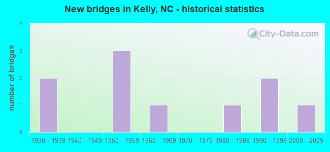
- New bridges - historical statistics
- 21930-1939
- 31950-1959
- 11960-1969
- 11980-1989
- 21990-1999
- 12000-2009


- Bridge Condition - Deck
- 20.0%Very good
- 20.0%Good
- 20.0%Satisfactory
- 20.0%Fair
- 20.0%Poor

- Bridge Condition - Superstructure
- 20.0%Very good
- 20.0%Good
- 20.0%Satisfactory
- 40.0%Fair

- Bridge Condition - Substructure
- 20.0%Very good
- 20.0%Good
- 40.0%Satisfactory
- 20.0%Fair

- Bridge Condition - Channel
- 50.0%Good
- 40.0%Satisfactory
- 10.0%Fair

- Bridge Condition - Culverts
- 40.0%Good
- 40.0%Satisfactory
- 20.0%Fair
Find on map >> Show street view
Structure Number: 170023, Location: 0.2 MI W. OF JCT NC210 (Lat: 34.460556, Lng: -78.277089), Route carried "on" structure: State highway 53, Year Built: 1990, Status: Open, Structure Length: 0.94m (3.08ft), Average Daily Traffic: 1,100 (year 2015), Truck Traffic: 7%, Average Future Daily Traffic: 2,200 (year 2040), Design Load: HS 20+Mod, Features Intersected: LYON SWAMP CANAL
Minimum Vertical Clearance: 30+ m (98+ ft), Kilometerpoint: 0.000, Lanes on structure: 2, Owner: State Highway Agency, Approaching Roadway Width: 8.2m (26.9ft), Skew: 3 degrees, Material/Design: Steel, Design/Construction: Culvert, Number Of Spans In Main Unit: 2, Length of Maximum Span: 3.6m (11.8ft)
Condition: Channel: Satisfactory, Culverts: Fair, Operating Rating: 89.8 metric tons, Method Used To Determine Operating Rating: Load and Resistance Factor (LRFR), Inventory Rating: 89.8 metric tons, Method Used To Determine Inventory Rating: Load and Resistance Factor (LRFR), Structural Evaluation: Somewhat better than minimum adequacy, Waterway Adequacy: Better than present minimum criteria, Approach Roadway Alignment: Equal to present desirable criteria, Designated Inspection Frequency: Every 24 months, Inspection Date: September 2020
Find on map >> Show street view
Structure Number: 170043, Location: 0.6 MI. E. OF JCT. NC210 (Lat: 34.464281, Lng: -78.257008), Route carried "on" structure: State highway 53, Year Built: 2002, Status: Open, Structure Length: 5.18m (16.99ft), Average Daily Traffic: 1,300 (year 2018), Truck Traffic: 7%, Average Future Daily Traffic: 2,600 (year 2040), Design Load: HS 20+Mod, Features Intersected: COLLY CREEK
Minimum Vertical Clearance: 30+ m (98+ ft), Kilometerpoint: 0.000, Lanes on structure: 2, Owner: State Highway Agency, Approaching Roadway Width: 9.4m (30.8ft), Material/Design: Prestressed concrete, Design/Construction: Slab, Number Of Spans In Main Unit: 5, Length of Maximum Span: 11.8m (38.7ft), Curb-To-Curb Width: 9.0m (29.5ft), Out-to-Out Width: 10.0m (32.8ft)
Condition: Deck: Very good, Superstructure: Very good, Substructure: Very good, Channel: Satisfactory, Operating Rating: 89.8 metric tons, Method Used To Determine Operating Rating: Load Factor (LF), Inventory Rating: 53.5 metric tons, Method Used To Determine Inventory Rating: Load Factor (LF), Structural Evaluation: Equal to present desirable criteria, Deck Geometry: Somewhat better than minimum adequacy, Waterway Adequacy: Better than present minimum criteria, Approach Roadway Alignment: Equal to present desirable criteria, Designated Inspection Frequency: Every 24 months, Underwater Inspection Frequency: Every 60 months, Inspection Date: May 2020, Underwater Inspection Date: November 2018, Deck Structure Type: Concrete Precast Panels, Wearing Surface/Protective System: Wearing Surface: Bituminous
Find on map >> Show street view
Structure Number: 170051, Location: 0.1 MI. S. JCT. SR1539 (Lat: 34.416469, Lng: -78.251147), Route carried "on" structure: State highway 11, Year Built: 1952, Status: Temporarily open, Structure Length: 10.36m (33.99ft), Average Daily Traffic: 3,000 (year 2019), Truck Traffic: 7%, Average Future Daily Traffic: 6,000 (year 2040), Design Load: HS 15, Features Intersected: WHITE OAK CANAL
Minimum Vertical Clearance: 30+ m (98+ ft), Kilometerpoint: 0.000, Lanes on structure: 2, Owner: State Highway Agency, Approaching Roadway Width: 7.9m (25.9ft), Material/Design: Concrete, Design/Construction: Tee Beam, Number Of Spans In Main Unit: 10, Length of Maximum Span: 10.0m (32.8ft), Curb or Sidewalk Widths: Left: 0.4m (1.3ft), Right: 0.4m (1.3ft), Curb-To-Curb Width: 7.9m (25.9ft), Out-to-Out Width: 9.5m (31.2ft)
Condition: Deck: Satisfactory, Superstructure: Fair, Substructure: Satisfactory, Channel: Good, Operating Rating: 52.6 metric tons, Method Used To Determine Operating Rating: Load Factor (LF), Inventory Rating: 31.7 metric tons, Method Used To Determine Inventory Rating: Load Factor (LF), Structural Evaluation: Somewhat better than minimum adequacy, Deck Geometry: High priority of corrective action, Waterway Adequacy: Better than present minimum criteria, Approach Roadway Alignment: Equal to present desirable criteria, Designated Inspection Frequency: Every 24 months, Inspection Date: August 2021, Deck Structure Type: Concrete Cast-file-Place, Wearing Surface/Protective System: Wearing Surface: Monolithic Concrete
Find on map >> Show street view
Structure Number: 170055, Location: 0.3 MI.S. OF JCT.SR1543 (Lat: 34.433278, Lng: -78.226550), Route carried "on" structure: State highway 11, Year Built: 1952, Status: Open, Structure Length: 2.07m (6.79ft), Average Daily Traffic: 2,400 (year 2019), Truck Traffic: 7%, Average Future Daily Traffic: 4,800 (year 2040), Design Load: HS 15, Features Intersected: LYON SWAMP CANAL
Minimum Vertical Clearance: 30+ m (98+ ft), Kilometerpoint: 0.000, Lanes on structure: 2, Owner: State Highway Agency, Approaching Roadway Width: 7.9m (25.9ft), Material/Design: Concrete, Design/Construction: Tee Beam, Number Of Spans In Main Unit: 2, Length of Maximum Span: 9.1m (29.9ft), Curb or Sidewalk Widths: Left: 0.5m (1.6ft), Right: 0.5m (1.6ft), Curb-To-Curb Width: 7.8m (25.6ft), Out-to-Out Width: 9.5m (31.2ft)
Condition: Deck: Fair, Superstructure: Fair, Substructure: Fair, Channel: Satisfactory, Operating Rating: 56.2 metric tons, Method Used To Determine Operating Rating: Load Factor (LF), Inventory Rating: 33.5 metric tons, Method Used To Determine Inventory Rating: Load Factor (LF), Structural Evaluation: Somewhat better than minimum adequacy, Deck Geometry: High priority of replacement, Waterway Adequacy: Better than present minimum criteria, Approach Roadway Alignment: Equal to present desirable criteria, Designated Inspection Frequency: Every 24 months, Underwater Inspection Frequency: Every 60 months, Inspection Date: July 2021, Underwater Inspection Date: December 2018, Deck Structure Type: Concrete Cast-file-Place, Wearing Surface/Protective System: Wearing Surface: Monolithic Concrete
Find on map >> Show street view
Structure Number: 170064, Location: 0.3 MI.W.JCT.NC53 (Lat: 34.480547, Lng: -78.355292), Route carried "on" structure: State highway 1730, Year Built: 1984, Status: Open, Structure Length: 0.97m (3.18ft), Average Daily Traffic: 380 (year 2011), Truck Traffic: 6%, Average Future Daily Traffic: 760 (year 2040), Design Load: HS 20+Mod, Features Intersected: CREEK
Minimum Vertical Clearance: 30+ m (98+ ft), Kilometerpoint: 0.000, Lanes on structure: 2, Owner: State Highway Agency, Approaching Roadway Width: 5.7m (18.7ft), Material/Design: Steel, Design/Construction: Culvert, Number Of Spans In Main Unit: 4, Length of Maximum Span: 1.8m (5.9ft)
Condition: Channel: Good, Culverts: Satisfactory, Operating Rating: 89.8 metric tons, Method Used To Determine Operating Rating: Load and Resistance Factor (LRFR), Inventory Rating: 89.8 metric tons, Method Used To Determine Inventory Rating: Load and Resistance Factor (LRFR), Structural Evaluation: Equal to present minimum criteria, Waterway Adequacy: Better than present minimum criteria, Approach Roadway Alignment: Equal to present desirable criteria, Designated Inspection Frequency: Every 24 months, Underwater Inspection Frequency: Every 60 months, Inspection Date: November 2020, Underwater Inspection Date: November 2020
Find on map >> Show street view
Structure Number: 170065, Location: 0.3 MI. N. JCT. SR1540 (Lat: 34.436908, Lng: -78.235861), Route carried "on" structure: State highway 1543, Year Built: 1954, Year Reconstructed: 1983, Status: Posted for load, Structure Length: 1.58m (5.18ft), Average Daily Traffic: 120 (year 2000), Truck Traffic: 6%, Average Future Daily Traffic: 240 (year 2040), Features Intersected: LYON SWAMP CANAL
Minimum Vertical Clearance: 30+ m (98+ ft), Kilometerpoint: 0.000, Lanes on structure: 2, Owner: State Highway Agency, Approaching Roadway Width: 3.9m (12.8ft), Material/Design: Wood or Timber, Design/Construction: Stringer/Multi-beam, Number Of Spans In Main Unit: 3, Length of Maximum Span: 5.1m (16.7ft), Curb-To-Curb Width: 5.8m (19.0ft), Out-to-Out Width: 6.0m (19.7ft)
Condition: Deck: Poor, Superstructure: Satisfactory, Substructure: Satisfactory, Channel: Good, Operating Rating: 25.4 metric tons, Method Used To Determine Operating Rating: Allowable Stress (AS), Inventory Rating: 18.1 metric tons, Method Used To Determine Inventory Rating: Allowable Stress (AS), Structural Evaluation: Somewhat better than minimum adequacy, Deck Geometry: High priority of corrective action, Waterway Adequacy: Equal to present minimum criteria, Approach Roadway Alignment: Equal to present desirable criteria, Bridge Posting: Required (Relationship of Operating Rating to Maximum Legal Load: > 39.9% below), Designated Inspection Frequency: Every 24 months, Inspection Date: August 2021, Deck Structure Type: Wood or Timber, Wearing Surface/Protective System: Wearing Surface: Bituminous
Find on map >> Show street view
Structure Number: 170153, Location: 0.1 MI.N. OF JCT.NC87 (Lat: 34.453253, Lng: -78.403072), Route carried "on" structure: State highway 1732, Year Built: 1993, Status: Open, Structure Length: 3.41m (11.19ft), Average Daily Traffic: 20 (year 2000), Average Future Daily Traffic: 40 (year 2040), Design Load: HS 20+Mod, Features Intersected: CARVERS CREEK
Minimum Vertical Clearance: 30+ m (98+ ft), Kilometerpoint: 0.000, Lanes on structure: 2, Owner: State Highway Agency, Approaching Roadway Width: 6.7m (22.0ft), Material/Design: Prestressed concrete, Design/Construction: Slab, Number Of Spans In Main Unit: 3, Length of Maximum Span: 11.8m (38.7ft), Curb-To-Curb Width: 7.2m (23.6ft), Out-to-Out Width: 8.2m (26.9ft)
Condition: Deck: Good, Superstructure: Good, Substructure: Good, Channel: Fair, Operating Rating: 89.8 metric tons, Method Used To Determine Operating Rating: Load Factor (LF), Inventory Rating: 58.0 metric tons, Method Used To Determine Inventory Rating: Load Factor (LF), Structural Evaluation: Better than present minimum criteria, Deck Geometry: Somewhat better than minimum adequacy, Waterway Adequacy: Better than present minimum criteria, Approach Roadway Alignment: Equal to present desirable criteria, Designated Inspection Frequency: Every 24 months, Underwater Inspection Frequency: Every 60 months, Inspection Date: July 2021, Underwater Inspection Date: March 2019, Deck Structure Type: Concrete Precast Panels, Wearing Surface/Protective System: Wearing Surface: Bituminous
Find on map >> Show street view
Structure Number: 170204, Location: 100FT.N.JCT.SR1732 (Lat: 34.452572, Lng: -78.403781), Route carried "on" structure: State highway 87, Year Built: 1930, Status: Open, Structure Length: 0.97m (3.18ft), Average Daily Traffic: 3,800 (year 2019), Truck Traffic: 8%, Average Future Daily Traffic: 7,600 (year 2040), Design Load: H 20, Features Intersected: CARVERS CREEK
Minimum Vertical Clearance: 30+ m (98+ ft), Kilometerpoint: 0.000, Lanes on structure: 2, Base Highway Network: Yes (Inventory Route: 3, Subroute: 87), Owner: State Highway Agency, Approaching Roadway Width: 9.7m (31.8ft), Material/Design: Concrete continuous, Design/Construction: Culvert, Number Of Spans In Main Unit: 3, Length of Maximum Span: 3.0m (9.8ft)
Condition: Channel: Good, Culverts: Satisfactory, Operating Rating: 41.7 metric tons, Method Used To Determine Operating Rating: Field evaluation and documented engineering judgment, Inventory Rating: 32.6 metric tons, Method Used To Determine Inventory Rating: Field evaluation and documented engineering judgment, Structural Evaluation: Equal to present minimum criteria, Waterway Adequacy: Equal to present minimum criteria, Approach Roadway Alignment: Equal to present desirable criteria, Designated Inspection Frequency: Every 24 months, Underwater Inspection Frequency: Every 60 months, Inspection Date: July 2021, Underwater Inspection Date: July 2021
Find on map >> Show street view
Structure Number: 170217, Location: 0.2MI.N.JCT.SR1770 (Lat: 34.440753, Lng: -78.372917), Route carried "on" structure: State highway 87, Year Built: 1930, Status: Open, Structure Length: 0.64m (2.10ft), Average Daily Traffic: 4,100 (year 2019), Truck Traffic: 8%, Average Future Daily Traffic: 8,200 (year 2040), Design Load: HS 20, Features Intersected: PLUMMERS RUN
Minimum Vertical Clearance: 30+ m (98+ ft), Kilometerpoint: 0.000, Lanes on structure: 2, Base Highway Network: Yes (Inventory Route: 3, Subroute: 87), Owner: State Highway Agency, Approaching Roadway Width: 10.9m (35.8ft), Material/Design: Concrete continuous, Design/Construction: Culvert, Number Of Spans In Main Unit: 2, Length of Maximum Span: 3.0m (9.8ft)
Condition: Channel: Good, Culverts: Good, Operating Rating: 41.7 metric tons, Method Used To Determine Operating Rating: Field evaluation and documented engineering judgment, Inventory Rating: 32.6 metric tons, Method Used To Determine Inventory Rating: Field evaluation and documented engineering judgment, Structural Evaluation: Better than present minimum criteria, Waterway Adequacy: Better than present minimum criteria, Approach Roadway Alignment: Equal to present desirable criteria, Designated Inspection Frequency: Every 24 months, Underwater Inspection Frequency: Every 60 months, Inspection Date: July 2021, Underwater Inspection Date: July 2021
Find on map >> Show street view
Structure Number: 170219, Location: 0.7MI.N. OF JCT.SR1539 (Lat: 34.425139, Lng: -78.246311), Route carried "on" structure: State highway 1543, Year Built: 1962, Status: Open, Structure Length: 0.64m (2.10ft), Average Daily Traffic: 120 (year 2000), Truck Traffic: 6%, Average Future Daily Traffic: 240 (year 2040), Design Load: HS 20+Mod, Features Intersected: BLACK SWAMP CREEK
Minimum Vertical Clearance: 30+ m (98+ ft), Kilometerpoint: 0.000, Lanes on structure: 2, Owner: State Highway Agency, Approaching Roadway Width: 6.0m (19.7ft), Material/Design: Steel, Design/Construction: Culvert, Number Of Spans In Main Unit: 2, Length of Maximum Span: 2.7m (8.9ft)
Condition: Channel: Satisfactory, Culverts: Good, Operating Rating: 89.8 metric tons, Method Used To Determine Operating Rating: Load and Resistance Factor (LRFR), Inventory Rating: 89.8 metric tons, Method Used To Determine Inventory Rating: Load and Resistance Factor (LRFR), Structural Evaluation: Better than present minimum criteria, Waterway Adequacy: Better than present minimum criteria, Approach Roadway Alignment: Equal to present desirable criteria, Designated Inspection Frequency: Every 24 months, Inspection Date: October 2021