Bridge Statistics for Kellyton, Alabama (AL)
Condition, Traffic, Stress, Structural Evaluation, Project Costs
- National Bridge Inventory (NBI) Statistics
- 12Number of bridges
- 135ft / 41.0mTotal length
- $13,567,000Total costs
- 39,583Total average daily traffic
- 6,964Total average daily truck traffic
- National Bridge Inventory (NBI) Registered Bridges for Kellyton
- No street view available for this location
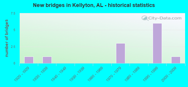
- New bridges - historical statistics
- 11920-1929
- 11930-1939
- 31970-1979
- 61990-1999
- 12000-2009


- Bridge Condition - Deck
- 11.1%Very good
- 22.2%Good
- 55.6%Satisfactory
- 11.1%Poor

- Bridge Condition - Superstructure
- 33.3%Very good
- 22.2%Good
- 33.3%Satisfactory
- 11.1%Serious

- Bridge Condition - Substructure
- 22.2%Very good
- 22.2%Good
- 44.4%Satisfactory
- 11.1%Poor

- Bridge Condition - Channel
- 62.5%Good
- 37.5%Fair
Find on map >> Show street view
Structure Number: 771, Location: 0.7 MI. N. W. SOCAPATOY (Lat: 32.996381, Lng: -86.085064), Route carried "on" structure: County highway 28, Year Built: 1930, Status: Posted for load, Structure Length: 2.50m (8.20ft), Average Daily Traffic: 46 (year 2021), Average Future Daily Traffic: 120 (year 2041), Features Intersected: Baker Creek
Minimum Vertical Clearance: 30+ m (98+ ft), Kilometerpoint: 0.010, Lanes on structure: 1, Owner: County Highway Agency, Approaching Roadway Width: 3.7m (12.1ft), Material/Design: Steel, Design/Construction: Stringer/Multi-beam, Number Of Spans In Main Unit: 5, Length of Maximum Span: 7.0m (23.0ft), Curb-To-Curb Width: 5.8m (19.0ft), Out-to-Out Width: 6.3m (20.7ft)
Condition: Deck: Poor, Superstructure: Serious, Substructure: Poor, Channel: Good, Operating Rating: 2.7 metric tons, Method Used To Determine Operating Rating: Allowable Stress (AS), Inventory Rating: 1.8 metric tons, Method Used To Determine Inventory Rating: Allowable Stress (AS), Structural Evaluation: High priority of replacement, Deck Geometry: Meets minimum limits, Waterway Adequacy: Better than present minimum criteria, Approach Roadway Alignment: Equal to present minimum criteria, Bridge Posting: Required (Relationship of Operating Rating to Maximum Legal Load: > 39.9% below), Length Of Structure Improvement: 3.38m (11.09ft), Designated Inspection Frequency: Every 24 months, Other Special Inspection Frequency: Every 3 months, Inspection Date: October 2021, Other Special Inspection Date: January 2022, Bridge Improvement Cost: $464,000, Roadway Improvement Cost: $46,000, Total Project Cost: $510,000 ( Estimate for 2022), Deck Structure Type: Concrete Cast-file-Place
Find on map >> Show street view
Structure Number: 1154, Location: 0.4 MI N JCT US 280 (Lat: 32.991472, Lng: -86.065917), Route carried "on" structure: US 9, Year Built: 1924, Year Reconstructed: 1935, Status: Open, Structure Length: 1.16m (3.81ft), Average Daily Traffic: 1,809 (year 2018), Truck Traffic: 10%, Average Future Daily Traffic: 2,533 (year 2038), Design Load: H 15, Features Intersected: SOCAPATOY CRK.
Minimum Vertical Clearance: 30+ m (98+ ft), Kilometerpoint: 252.488, Lanes on structure: 2, Base Highway Network: Yes, Owner: State Highway Agency, Approaching Roadway Width: 7.3m (24.0ft), Material/Design: Concrete, Design/Construction: Tee Beam, Number Of Spans In Main Unit: 1, Length of Maximum Span: 11.0m (36.1ft), Curb or Sidewalk Widths: Left: 0.1m (0.3ft), Right: 0.1m (0.3ft), Curb-To-Curb Width: 7.3m (24.0ft), Out-to-Out Width: 7.6m (24.9ft)
Condition: Deck: Satisfactory, Superstructure: Good, Substructure: Satisfactory, Channel: Fair, Operating Rating: 57.1 metric tons, Method Used To Determine Operating Rating: Load Factor (LF), Inventory Rating: 34.5 metric tons, Method Used To Determine Inventory Rating: Load Factor (LF), Structural Evaluation: Equal to present minimum criteria, Deck Geometry: Meets minimum limits, Waterway Adequacy: Equal to present minimum criteria, Approach Roadway Alignment: Equal to present desirable criteria, Length Of Structure Improvement: 1.84m (6.04ft), Designated Inspection Frequency: Every 24 months, Inspection Date: June 2020, Bridge Improvement Cost: $302,000, Roadway Improvement Cost: $30,000, Total Project Cost: $332,000 ( Estimate for 2022), Deck Structure Type: Concrete Cast-file-Place
Find on map >> Show street view
Structure Number: 11645, Location: 11.4 MI E. TALL CO LINE (Lat: 32.999528, Lng: -86.080806), Route carried "on" structure: State highway 38, Year Built: 1976, Status: Open, Structure Length: 5.18m (16.99ft), Average Daily Traffic: 5,656 (year 2018), Truck Traffic: 17%, Average Future Daily Traffic: 7,918 (year 2038), Design Load: HS 20, Features Intersected: BAKER CREEK
Minimum Vertical Clearance: 30+ m (98+ ft), Kilometerpoint: 94.338, Lanes on structure: 2, Base Highway Network: Yes, Owner: State Highway Agency, Approaching Roadway Width: 13.4m (44.0ft), Material/Design: Concrete, Design/Construction: Tee Beam, Number Of Spans In Main Unit: 5, Length of Maximum Span: 10.4m (34.1ft), Curb-To-Curb Width: 12.0m (39.4ft), Out-to-Out Width: 12.5m (41.0ft)
Condition: Deck: Satisfactory, Superstructure: Satisfactory, Substructure: Satisfactory, Channel: Fair, Operating Rating: 41.4 metric tons, Method Used To Determine Operating Rating: Load Factor (LF), Inventory Rating: 30.5 metric tons, Method Used To Determine Inventory Rating: Load Factor (LF), Structural Evaluation: Equal to present minimum criteria, Deck Geometry: Better than present minimum criteria, Waterway Adequacy: Equal to present minimum criteria, Approach Roadway Alignment: Equal to present desirable criteria, Length Of Structure Improvement: 6.20m (20.34ft), Designated Inspection Frequency: Every 24 months, Inspection Date: July 2020, Bridge Improvement Cost: $1,744,000, Roadway Improvement Cost: $174,000, Total Project Cost: $1,918,000 ( Estimate for 2022), Deck Structure Type: Concrete Cast-file-Place
Find on map >> Show street view
Structure Number: 11646, Location: 11.4 MI E. TALL CO LINE (Lat: 32.999389, Lng: -86.080972), Route carried "on" structure: State highway 38, Year Built: 1976, Status: Open, Structure Length: 5.18m (16.99ft), Average Daily Traffic: 5,656 (year 2018), Truck Traffic: 17%, Average Future Daily Traffic: 7,918 (year 2038), Design Load: HS 20, Features Intersected: BAKER CREEK
Minimum Vertical Clearance: 30+ m (98+ ft), Kilometerpoint: 94.338, Lanes on structure: 2, Base Highway Network: Yes, Owner: State Highway Agency, Approaching Roadway Width: 13.4m (44.0ft), Material/Design: Concrete, Design/Construction: Tee Beam, Number Of Spans In Main Unit: 5, Length of Maximum Span: 10.4m (34.1ft), Curb-To-Curb Width: 12.0m (39.4ft), Out-to-Out Width: 12.5m (41.0ft)
Condition: Deck: Satisfactory, Superstructure: Satisfactory, Substructure: Satisfactory, Channel: Fair, Operating Rating: 41.4 metric tons, Method Used To Determine Operating Rating: Load Factor (LF), Inventory Rating: 30.5 metric tons, Method Used To Determine Inventory Rating: Load Factor (LF), Structural Evaluation: Equal to present minimum criteria, Deck Geometry: Better than present minimum criteria, Waterway Adequacy: Equal to present minimum criteria, Approach Roadway Alignment: Equal to present desirable criteria, Length Of Structure Improvement: 6.20m (20.34ft), Designated Inspection Frequency: Every 24 months, Inspection Date: July 2020, Bridge Improvement Cost: $1,744,000, Roadway Improvement Cost: $174,000, Total Project Cost: $1,918,000 ( Estimate for 2022), Deck Structure Type: Concrete Cast-file-Place
Find on map >> Show street view
Structure Number: 12037, Location: 1.22 MI. NW KELLYTON (Lat: 32.991706, Lng: -86.039967), Route carried "on" structure: County highway 77, Year Built: 1978, Status: Open, Structure Length: 1.46m (4.79ft), Average Daily Traffic: 527 (year 2021), Truck Traffic: 1%, Average Future Daily Traffic: 555 (year 2041), Design Load: HS 20, Features Intersected: Socapatoy Creek
Minimum Vertical Clearance: 30+ m (98+ ft), Kilometerpoint: 0.010, Lanes on structure: 2, Owner: County Highway Agency, Approaching Roadway Width: 5.5m (18.0ft), Material/Design: Concrete, Design/Construction: Channel Beam, Number Of Spans In Main Unit: 2, Length of Maximum Span: 7.3m (24.0ft), Curb-To-Curb Width: 7.3m (24.0ft), Out-to-Out Width: 7.9m (25.9ft)
Condition: Deck: Satisfactory, Superstructure: Satisfactory, Substructure: Satisfactory, Channel: Good, Operating Rating: 52.4 metric tons, Method Used To Determine Operating Rating: Load Factor (LF), Inventory Rating: 31.5 metric tons, Method Used To Determine Inventory Rating: Load Factor (LF), Structural Evaluation: Equal to present minimum criteria, Deck Geometry: Meets minimum limits, Waterway Adequacy: Equal to present desirable criteria, Approach Roadway Alignment: Equal to present minimum criteria, Length Of Structure Improvement: 2.14m (7.02ft), Designated Inspection Frequency: Every 24 months, Inspection Date: March 2021, Bridge Improvement Cost: $382,000, Roadway Improvement Cost: $38,000, Total Project Cost: $420,000 ( Estimate for 2022), Deck Structure Type: Concrete Precast Panels, Wearing Surface/Protective System: Wearing Surface: Monolithic Concrete
Find on map >> Show street view
Structure Number: 15385, Location: 1.2 MI E PISGAH RD (Lat: 32.991519, Lng: -86.092831), Route carried "on" structure: County highway , Year Built: 1991, Status: Open, Structure Length: 4.15m (13.62ft), Average Daily Traffic: 75 (year 1988), Average Future Daily Traffic: 150 (year 2040), Design Load: HS 20, Features Intersected: GREENBRIER CRK. RELIEF, Facility Carried by Structure: CENTERPOINT RD.
Minimum Vertical Clearance: 30+ m (98+ ft), Kilometerpoint: 0.010, Lanes on structure: 2, Owner: County Highway Agency, Approaching Roadway Width: 11.0m (36.1ft), Material/Design: Concrete, Design/Construction: Channel Beam, Number Of Spans In Main Unit: 4, Length of Maximum Span: 10.4m (34.1ft), Curb-To-Curb Width: 8.6m (28.2ft), Out-to-Out Width: 9.4m (30.8ft)
Condition: Deck: Very good, Superstructure: Very good, Substructure: Very good, Channel: Good, Operating Rating: 58.9 metric tons, Method Used To Determine Operating Rating: Load Factor (LF), Inventory Rating: 35.3 metric tons, Method Used To Determine Inventory Rating: Load Factor (LF), Structural Evaluation: Equal to present desirable criteria, Deck Geometry: Better than present minimum criteria, Waterway Adequacy: Better than present minimum criteria, Approach Roadway Alignment: Better than present minimum criteria, Length Of Structure Improvement: 5.12m (16.80ft), Designated Inspection Frequency: Every 24 months, Inspection Date: August 2020, Bridge Improvement Cost: $1,053,000, Roadway Improvement Cost: $105,000, Total Project Cost: $1,158,000 ( Estimate for 2022), Deck Structure Type: Concrete Precast Panels, Wearing Surface/Protective System: Membrane: Other, Deck Protection: Other
Find on map >> Show street view
Structure Number: 17397, Location: 1 MILE SOUTH OF KANSAS (Lat: 33.000000, Lng: -86.000000), Route carried "on" structure: County highway , Year Built: 1998, Status: Open, Structure Length: 1.83m (6.00ft), Average Daily Traffic: 50 (year 1999), Average Future Daily Traffic: 190 (year 2031), Features Intersected: UNNAMED TRIB OF LOST CRK, Facility Carried by Structure: HALEY BOTTOMS ROAD
Minimum Vertical Clearance: 7.56m (24.80ft), Kilometerpoint: 0.000, Lanes on structure: 2, Owner: County Highway Agency, Approaching Roadway Width: 5.8m (19.0ft), Material/Design: Steel, Design/Construction: Stringer/Multi-beam, Number Of Spans In Main Unit: 1, Length of Maximum Span: 18.3m (60.0ft), Curb-To-Curb Width: 6.1m (20.0ft), Out-to-Out Width: 6.1m (20.0ft)
Condition: Deck: Good, Superstructure: Good, Substructure: Good, Channel: Good, Operating Rating: 65.8 metric tons, Method Used To Determine Operating Rating: Load Factor (LF), Inventory Rating: 39.4 metric tons, Method Used To Determine Inventory Rating: Load Factor (LF), Structural Evaluation: Better than present minimum criteria, Deck Geometry: Somewhat better than minimum adequacy, Waterway Adequacy: Better than present minimum criteria, Approach Roadway Alignment: Equal to present minimum criteria, Length Of Structure Improvement: 2.54m (8.33ft), Designated Inspection Frequency: Every 24 months, Inspection Date: November 2021, Bridge Improvement Cost: $349,000, Roadway Improvement Cost: $35,000, Total Project Cost: $384,000 ( Estimate for 2022), Deck Structure Type: Concrete Cast-file-Place
Find on map >> Show street view
Structure Number: 17683, Location: 3 MI WEST OF ALEX CITY (Lat: 32.985800, Lng: -86.066000), Route carried "on" structure: US 280, Year Built: 1999, Status: Open, Structure Length: 9.38m (30.77ft), Average Daily Traffic: 11,312 (year 2018), Truck Traffic: 17%, Average Future Daily Traffic: 15,837 (year 2038), Design Load: HS 20, Features Intersected: AL. 9
Minimum Vertical Clearance: 30+ m (98+ ft), Kilometerpoint: 96.554, Lanes on structure: 2, Lanes under structure: 3, Base Highway Network: Yes, Owner: State Highway Agency, Approaching Roadway Width: 8.1m (26.6ft), Skew: 3 degrees, Material/Design: Prestressed concrete, Design/Construction: Stringer/Multi-beam, Number Of Spans In Main Unit: 3, Length of Maximum Span: 39.3m (128.9ft), Curb-To-Curb Width: 12.1m (39.7ft), Out-to-Out Width: 12.9m (42.3ft)
Condition: Deck: Satisfactory, Superstructure: Very good, Substructure: Good, Operating Rating: 75.7 metric tons, Method Used To Determine Operating Rating: Load Factor (LF), Inventory Rating: 45.6 metric tons, Method Used To Determine Inventory Rating: Load Factor (LF), Structural Evaluation: Better than present minimum criteria, Deck Geometry: Better than present minimum criteria, Underclear: Equal to present minimum criteria, Approach Roadway Alignment: Equal to present desirable criteria, Length Of Structure Improvement: 10.33m (33.89ft), Designated Inspection Frequency: Every 24 months, Inspection Date: Febuary 2022, Bridge Improvement Cost: $2,976,000, Roadway Improvement Cost: $298,000, Total Project Cost: $3,274,000 ( Estimate for 2022), Deck Structure Type: Concrete Cast-file-Place
Find on map >> Show street view
Structure Number: 17684, Location: 3 MI. WEST OF ALEX CITY (Lat: 32.985522, Lng: -86.066089), Route carried "on" structure: US 280, Year Built: 1999, Status: Open, Structure Length: 9.51m (31.20ft), Average Daily Traffic: 10,706 (year 2020), Truck Traffic: 21%, Average Future Daily Traffic: 14,988 (year 2040), Design Load: HS 20, Features Intersected: AL.9
Minimum Vertical Clearance: 8.46m (27.76ft), Kilometerpoint: 96.554, Lanes on structure: 2, Lanes under structure: 3, Base Highway Network: Yes, Owner: State Highway Agency, Approaching Roadway Width: 8.4m (27.6ft), Skew: 3 degrees, Material/Design: Prestressed concrete, Design/Construction: Stringer/Multi-beam, Number Of Spans In Main Unit: 3, Length of Maximum Span: 39.9m (130.9ft), Curb-To-Curb Width: 12.2m (40.0ft), Out-to-Out Width: 13.0m (42.7ft)
Condition: Deck: Good, Superstructure: Very good, Substructure: Very good, Operating Rating: 86.7 metric tons, Method Used To Determine Operating Rating: Load Factor (LF), Inventory Rating: 44.2 metric tons, Method Used To Determine Inventory Rating: Load Factor (LF), Structural Evaluation: Equal to present desirable criteria, Deck Geometry: Better than present minimum criteria, Underclear: Equal to present minimum criteria, Approach Roadway Alignment: Equal to present desirable criteria, Length Of Structure Improvement: 10.46m (34.32ft), Designated Inspection Frequency: Every 24 months, Inspection Date: Febuary 2022, Bridge Improvement Cost: $3,012,000, Roadway Improvement Cost: $301,000, Total Project Cost: $3,313,000 ( Estimate for 2022), Deck Structure Type: Concrete Cast-file-Place
Find on map >> Show street view
Structure Number: 19085, Location: 0.51 MI N CR-65 (Lat: 32.954994, Lng: -86.022772), Route carried "on" structure: County highway 89, Year Built: 2003, Status: Open, Structure Length: 0.62m (2.03ft), Average Daily Traffic: 171 (year 2022), Truck Traffic: 15%, Average Future Daily Traffic: 244 (year 2042), Design Load: HS 20, Features Intersected: Harold Creek
Minimum Vertical Clearance: 30+ m (98+ ft), Kilometerpoint: 0.010, Lanes on structure: 2, Owner: County Highway Agency, Approaching Roadway Width: 6.1m (20.0ft), Material/Design: Concrete, Design/Construction: Culvert, Number Of Spans In Main Unit: 2, Length of Maximum Span: 3.0m (9.8ft)
Condition: Channel: Good, Culverts: Good, Operating Rating: 88.9 metric tons, Method Used To Determine Operating Rating: Load Factor (LF), Inventory Rating: 88.9 metric tons, Method Used To Determine Inventory Rating: Load Factor (LF), Structural Evaluation: Better than present minimum criteria, Waterway Adequacy: Better than present minimum criteria, Approach Roadway Alignment: Better than present minimum criteria, Length Of Structure Improvement: 1.24m (4.07ft), Designated Inspection Frequency: Every 24 months, Inspection Date: March 2022, Bridge Improvement Cost: $309,000, Roadway Improvement Cost: $31,000, Total Project Cost: $340,000 ( Estimate for 2022)
Find on map >> Show street view
Structure Number: 17683, Location: 3 MI WEST OF ALEX CITY (Lat: 32.985800, Lng: -86.066000), Route carried "under" structure: State highway 9, Year Built: 1999, Structure Length: 0. m, Average Daily Traffic: 1,809 (year 2018), Truck Traffic: 22%, Features Intersected: AL. 9, Facility Carried by Structure: SR38/US280
Minimum Vertical Clearance: 6.00m (19.69ft), Kilometerpoint: 252.015, Lanes on structure: 2, Lanes under structure: 3, Material/Design: Prestressed concrete, Design/Construction: Stringer/Multi-beam, Length of Maximum Span: 39.3m (128.9ft)
Find on map >> Show street view
Structure Number: 17684, Location: 3 MI. WEST OF ALEX CITY (Lat: 32.985522, Lng: -86.066089), Route carried "under" structure: State highway 9, Year Built: 1999, Structure Length: 0. m, Average Daily Traffic: 1,766 (year 2020), Truck Traffic: 15%, Features Intersected: AL.9, Facility Carried by Structure: SR38/US280
Minimum Vertical Clearance: 6.15m (20.18ft), Kilometerpoint: 252.015, Lanes on structure: 2, Lanes under structure: 3, Material/Design: Prestressed concrete, Design/Construction: Stringer/Multi-beam, Length of Maximum Span: 39.9m (130.9ft)