Bridge Statistics for Kelso, Washington (WA)
Condition, Traffic, Stress, Structural Evaluation, Project Costs
- National Bridge Inventory (NBI) Statistics
- 37Number of bridges
- 846ft / 258mTotal length
- $201,052,000Total costs
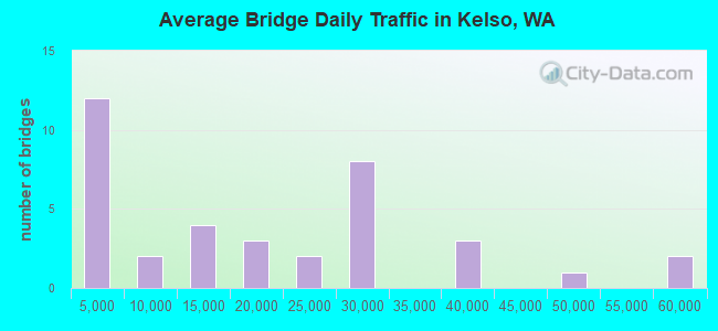
- 682,262Total average daily traffic
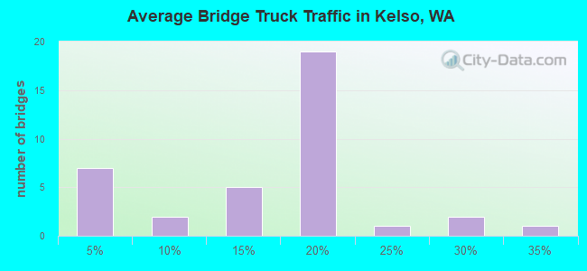
- 107,139Total average daily truck traffic
- National Bridge Inventory (NBI) Registered Bridges for Kelso
- No street view available for this location
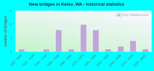
- New bridges - historical statistics
- 11920-1929
- 11940-1949
- 81950-1959
- 11960-1969
- 101970-1979
- 81980-1989
- 11990-1999
- 22000-2009
- 42010-2019
- 12020-2022
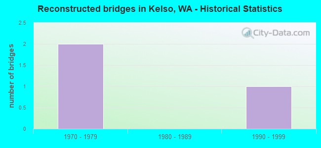
- Reconstructed bridges - Historical Statistics
- 21970-1979
- 01980-1989
- 11990-1999
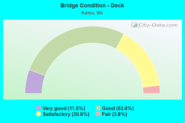
- Bridge Condition - Deck
- 11.5%Very good
- 53.8%Good
- 30.8%Satisfactory
- 3.8%Fair
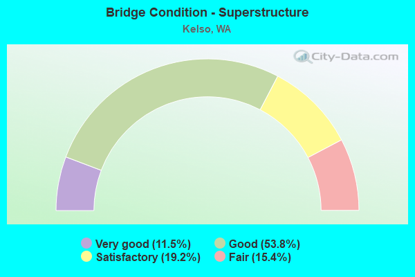
- Bridge Condition - Superstructure
- 11.5%Very good
- 53.8%Good
- 19.2%Satisfactory
- 15.4%Fair
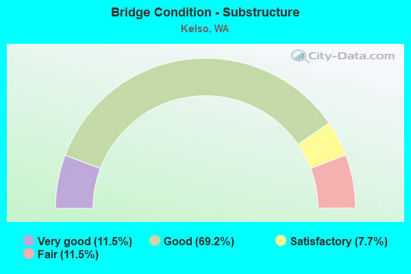
- Bridge Condition - Substructure
- 11.5%Very good
- 69.2%Good
- 7.7%Satisfactory
- 11.5%Fair
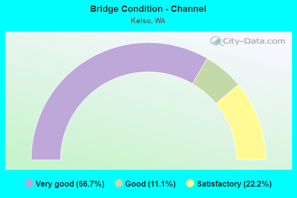
- Bridge Condition - Channel
- 66.7%Very good
- 11.1%Good
- 22.2%Satisfactory
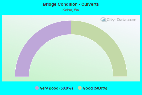
- Bridge Condition - Culverts
- 50.0%Very good
- 50.0%Good
Find on map >> Show street view
Structure Number: 3093A, Location: 0.6 S. OF ALLEN ST. (Lat: 46.137761, Lng: -122.897392), Route carried "on" structure: City street 500, Year Built: 1947, Status: Open, Structure Length: 14.87m (48.79ft), Average Daily Traffic: 1,500 (year 2010), Truck Traffic: 5%, Average Future Daily Traffic: 1,650 (year 2030), Design Load: H 20, Features Intersected: COWEEMAN R, Facility Carried by Structure: KELSO DR
Minimum Vertical Clearance: 4.80m (15.75ft), Kilometerpoint: 0.001, Lanes on structure: 2, Lanes under structure: 4, Owner: City or Municipal Highway Agency, Approaching Roadway Width: 12.2m (40.0ft), Material/Design: Steel, Design/Construction: Truss - Thru, Number Of Spans In Main Unit: 1, Number Of Approach Spans: 7, Length of Maximum Span: 61.0m (200.1ft), Curb or Sidewalk Widths: Left: 0.5m (1.6ft), Right: 1.4m (4.6ft), Curb-To-Curb Width: 8.5m (27.9ft), Out-to-Out Width: 10.7m (35.1ft)
Condition: Deck: Good, Superstructure: Good, Substructure: Good, Channel: Very good, Operating Rating: 20.4 metric tons, Method Used To Determine Operating Rating: Load and Resistance Factor Rating (LRFR) rating reported by rating factor(RF) method using HL-93 loadings, Inventory Rating: 15.6 metric tons, Method Used To Determine Inventory Rating: Load and Resistance Factor Rating (LRFR) rating reported by rating factor(RF) method using HL-93 loadings, Structural Evaluation: Meets minimum limits, Deck Geometry: Somewhat better than minimum adequacy, Underclear: High priority of replacement, Waterway Adequacy: Equal to present desirable criteria, Approach Roadway Alignment: Equal to present desirable criteria, Length Of Structure Improvement: 15.18m (49.80ft), Designated Inspection Frequency: Every 24 months, Critical Feature Inspection Frequency: Every 24 months, Inspection Date: December 2020, Critical Feature Inspection Date: December 2020, Bridge Improvement Cost: $7,570,000, Roadway Improvement Cost: $1,514,000, Total Project Cost: $15,139,000 ( Estimate for 2014), Deck Structure Type: Concrete Cast-file-Place, Wearing Surface/Protective System: Wearing Surface: Bituminous
Find on map >> Show street view
Structure Number: 3717A, Location: 0.1 E JCT SR 411 SP (Lat: 46.147289, Lng: -122.917972), Route carried "on" structure: State highway 4, Year Built: 1951, Status: Posted for load, Structure Length: 52.12m (171.00ft), Average Daily Traffic: 18,155 (year 2019), Truck Traffic: 2%, Average Future Daily Traffic: 24,255 (year 2039), Design Load: HS 20, Features Intersected: COWLITZ R / RR / SR 411
Minimum Vertical Clearance: 5.36m (17.59ft), Kilometerpoint: 98.299, Lanes on structure: 4, Lanes under structure: 8, Base Highway Network: Yes, Owner: State Highway Agency, Approaching Roadway Width: 17.1m (56.1ft), Skew: 20 degrees, Navigation Control: Yes ( Vertical Clearance: 19.5m (64.0ft), Horizontal Clearance: 73.2m (240.2ft)), Material/Design: Steel continuous, Design/Construction: Truss - Thru, Number Of Spans In Main Unit: 3, Number Of Approach Spans: 20, Length of Maximum Span: 78.0m (255.9ft), Curb or Sidewalk Widths: Left: 1.5m (4.9ft), Right: 1.5m (4.9ft), Curb-To-Curb Width: 17.1m (56.1ft), Out-to-Out Width: 17.7m (58.1ft)
Condition: Deck: Satisfactory, Superstructure: Fair, Substructure: Fair, Channel: Very good, Operating Rating: 33.6 metric tons, Method Used To Determine Operating Rating: Load Factor (LF), Inventory Rating: 20.0 metric tons, Method Used To Determine Inventory Rating: Load Factor (LF), Structural Evaluation: Somewhat better than minimum adequacy, Deck Geometry: Somewhat better than minimum adequacy, Underclear: High priority of corrective action, Waterway Adequacy: Equal to present desirable criteria, Approach Roadway Alignment: Equal to present desirable criteria, Bridge Posting: Required (Relationship of Operating Rating to Maximum Legal Load: 10.0 - 19.9% below), Length Of Structure Improvement: 52.12m (171.00ft), Designated Inspection Frequency: Every 24 months, Critical Feature Inspection Frequency: Every 24 months, Underwater Inspection Frequency: Every 60 months, Inspection Date: September 2020, Critical Feature Inspection Date: September 2020, Underwater Inspection Date: September 2020, Bridge Improvement Cost: $19,836,000, Roadway Improvement Cost: $3,967,000, Total Project Cost: $39,672,000 ( Estimate for 2014), Deck Structure Type: Concrete Cast-file-Place, Wearing Surface/Protective System: Wearing Surface: Monolithic Concrete
Find on map >> Show street view
Structure Number: 5968A, Location: 2.7 E JCT SR 411 (Lat: 46.106917, Lng: -122.879583), Route carried "on" structure: State highway 432, Year Built: 1959, Year Reconstructed: 1976, Status: Open, Structure Length: 8.53m (27.99ft), Average Daily Traffic: 36,745 (year 2019), Truck Traffic: 3%, Average Future Daily Traffic: 49,091 (year 2039), Design Load: HS 20, Features Intersected: I-5
Minimum Vertical Clearance: 30+ m (98+ ft), Kilometerpoint: 16.560, Lanes on structure: 4, Lanes under structure: 8, Base Highway Network: Yes, Owner: State Highway Agency, Approaching Roadway Width: 17.4m (57.1ft), Skew: 33 degrees, Material/Design: Prestressed concrete, Design/Construction: Stringer/Multi-beam, Number Of Spans In Main Unit: 4, Number Of Approach Spans: 2, Length of Maximum Span: 18.3m (60.0ft), Curb-To-Curb Width: 16.8m (55.1ft), Out-to-Out Width: 18.1m (59.4ft)
Condition: Deck: Good, Superstructure: Fair, Substructure: Good, Operating Rating: 45.4 metric tons, Method Used To Determine Operating Rating: Load Factor (LF), Inventory Rating: 39.0 metric tons, Method Used To Determine Inventory Rating: Load Factor (LF), Structural Evaluation: Somewhat better than minimum adequacy, Deck Geometry: Meets minimum limits, Underclear: High priority of corrective action, Approach Roadway Alignment: Equal to present desirable criteria, Length Of Structure Improvement: 8.53m (27.99ft), Designated Inspection Frequency: Every 24 months, Inspection Date: May 2021, Bridge Improvement Cost: $3,304,000, Roadway Improvement Cost: $661,000, Total Project Cost: $6,608,000 ( Estimate for 2014), Deck Structure Type: Concrete Cast-file-Place, Wearing Surface/Protective System: Wearing Surface: Latex Concrete
Find on map >> Show street view
Structure Number: 6025A, Location: 15.8 N JCT SR 503 (Lat: 46.105139, Lng: -122.876333), Route carried "on" structure: Ramp Interstate 5, Year Built: 1959, Status: Open, Structure Length: 5.58m (18.31ft), Average Daily Traffic: 13,076 (year 2019), Truck Traffic: 17%, Average Future Daily Traffic: 17,469 (year 2039), Design Load: HS 20, Features Intersected: SR 432 E-S RAMP
Minimum Vertical Clearance: 30+ m (98+ ft), Kilometerpoint: 0.950, Lanes on structure: 1, Lanes under structure: 1, Owner: State Highway Agency, Approaching Roadway Width: 10.1m (33.1ft), Material/Design: Concrete continuous, Design/Construction: Box Beam or Girders - Multiple, Number Of Spans In Main Unit: 3, Length of Maximum Span: 21.9m (71.9ft), Curb-To-Curb Width: 9.6m (31.5ft), Out-to-Out Width: 10.4m (34.1ft)
Condition: Deck: Good, Superstructure: Satisfactory, Substructure: Good, Operating Rating: 56.2 metric tons, Method Used To Determine Operating Rating: Load Factor (LF), Inventory Rating: 33.6 metric tons, Method Used To Determine Inventory Rating: Load Factor (LF), Structural Evaluation: Equal to present minimum criteria, Deck Geometry: Superior to present desirable criteria, Underclear: Equal to present minimum criteria, Approach Roadway Alignment: Equal to present desirable criteria, Length Of Structure Improvement: 5.58m (18.31ft), Designated Inspection Frequency: Every 24 months, Inspection Date: October 2021, Bridge Improvement Cost: $1,281,000, Roadway Improvement Cost: $256,000, Total Project Cost: $2,562,000 ( Estimate for 2014), Deck Structure Type: Concrete Cast-file-Place, Wearing Surface/Protective System: Wearing Surface: Latex Concrete
Find on map >> Show street view
Structure Number: 9136A, Location: 14.7 N JCT SR 503 (Lat: 46.091022, Lng: -122.870447), Route carried "on" structure: Interstate 5, Year Built: 1972, Status: Open, Structure Length: 3.90m (12.80ft), Average Daily Traffic: 36,631 (year 2019), Truck Traffic: 17%, Average Future Daily Traffic: 48,939 (year 2039), Design Load: HS 20+Mod, Features Intersected: OWL CREEK
Minimum Vertical Clearance: 30+ m (98+ ft), Kilometerpoint: 57.615, Lanes on structure: 3, Base Highway Network: Yes, Owner: State Highway Agency, Approaching Roadway Width: 15.8m (51.8ft), Material/Design: Concrete continuous, Design/Construction: Slab, Number Of Spans In Main Unit: 5, Length of Maximum Span: 8.5m (27.9ft), Curb or Sidewalk Widths: Left: 0.2m (0.7ft), Right: 0.2m (0.7ft), Curb-To-Curb Width: 15.8m (51.8ft), Out-to-Out Width: 16.8m (55.1ft)
Condition: Deck: Good, Superstructure: Good, Substructure: Good, Channel: Very good, Operating Rating: 32.4 metric tons, Method Used To Determine Operating Rating: Load and Resistance Factor Rating (LRFR) rating reported by rating factor(RF) method using HL-93 loadings, Inventory Rating: 24.9 metric tons, Method Used To Determine Inventory Rating: Load and Resistance Factor Rating (LRFR) rating reported by rating factor(RF) method using HL-93 loadings, Structural Evaluation: Equal to present minimum criteria, Deck Geometry: Somewhat better than minimum adequacy, Waterway Adequacy: Equal to present desirable criteria, Approach Roadway Alignment: Equal to present desirable criteria, Length Of Structure Improvement: 3.90m (12.80ft), Designated Inspection Frequency: Every 24 months, Inspection Date: October 2021, Bridge Improvement Cost: $1,382,000, Roadway Improvement Cost: $276,000, Total Project Cost: $2,765,000 ( Estimate for 2014), Deck Structure Type: Concrete Cast-file-Place, Wearing Surface/Protective System: Wearing Surface: Bituminous
Find on map >> Show street view
Structure Number: 9136B, Location: 14.7 N JCT SR 503 (Lat: 46.090983, Lng: -122.870803), Route carried "on" structure: Interstate 5, Year Built: 1972, Status: Open, Structure Length: 3.90m (12.80ft), Average Daily Traffic: 36,631 (year 2019), Truck Traffic: 17%, Average Future Daily Traffic: 48,939 (year 2039), Design Load: HS 20+Mod, Features Intersected: OWL CREEK
Minimum Vertical Clearance: 30+ m (98+ ft), Kilometerpoint: 57.615, Lanes on structure: 3, Base Highway Network: Yes, Owner: State Highway Agency, Approaching Roadway Width: 15.8m (51.8ft), Material/Design: Concrete continuous, Design/Construction: Slab, Number Of Spans In Main Unit: 5, Length of Maximum Span: 7.6m (24.9ft), Curb or Sidewalk Widths: Left: 0.2m (0.7ft), Right: 0.2m (0.7ft), Curb-To-Curb Width: 15.8m (51.8ft), Out-to-Out Width: 16.9m (55.4ft)
Condition: Deck: Good, Superstructure: Good, Substructure: Good, Channel: Very good, Operating Rating: 32.7 metric tons, Method Used To Determine Operating Rating: Load and Resistance Factor Rating (LRFR) rating reported by rating factor(RF) method using HL-93 loadings, Inventory Rating: 25.3 metric tons, Method Used To Determine Inventory Rating: Load and Resistance Factor Rating (LRFR) rating reported by rating factor(RF) method using HL-93 loadings, Structural Evaluation: Equal to present minimum criteria, Deck Geometry: Somewhat better than minimum adequacy, Waterway Adequacy: Equal to present desirable criteria, Approach Roadway Alignment: Equal to present desirable criteria, Length Of Structure Improvement: 3.90m (12.80ft), Designated Inspection Frequency: Every 24 months, Inspection Date: October 2021, Bridge Improvement Cost: $1,382,000, Roadway Improvement Cost: $276,000, Total Project Cost: $2,765,000 ( Estimate for 2014), Deck Structure Type: Concrete Cast-file-Place, Wearing Surface/Protective System: Wearing Surface: Monolithic Concrete
Find on map >> Show street view
Structure Number: 10495A, Location: 0.9 N JCT SR 4 (Lat: 46.156806, Lng: -122.902361), Route carried "on" structure: Interstate 5, Year Built: 1979, Status: Open, Structure Length: 3.81m (12.50ft), Average Daily Traffic: 26,986 (year 2019), Truck Traffic: 19%, Average Future Daily Traffic: 36,053 (year 2039), Design Load: HS 20+Mod, Features Intersected: KELSO AVE (OLD SR 431)
Minimum Vertical Clearance: 30+ m (98+ ft), Kilometerpoint: 65.484, Lanes on structure: 3, Lanes under structure: 2, Base Highway Network: Yes, Owner: State Highway Agency, Approaching Roadway Width: 15.8m (51.8ft), Skew: 2 degrees, Material/Design: Prestressed concrete, Design/Construction: Stringer/Multi-beam, Number Of Spans In Main Unit: 1, Length of Maximum Span: 36.6m (120.1ft), Curb-To-Curb Width: 15.8m (51.8ft), Out-to-Out Width: 16.8m (55.1ft)
Condition: Deck: Good, Superstructure: Good, Substructure: Good, Operating Rating: 60.8 metric tons, Method Used To Determine Operating Rating: Load Factor (LF), Inventory Rating: 35.4 metric tons, Method Used To Determine Inventory Rating: Load Factor (LF), Structural Evaluation: Better than present minimum criteria, Deck Geometry: Somewhat better than minimum adequacy, Underclear: Somewhat better than minimum adequacy, Approach Roadway Alignment: Equal to present desirable criteria, Length Of Structure Improvement: 3.81m (12.50ft), Designated Inspection Frequency: Every 48 months, Inspection Date: April 2018, Bridge Improvement Cost: $1,350,000, Roadway Improvement Cost: $270,000, Total Project Cost: $2,700,000 ( Estimate for 2014), Deck Structure Type: Concrete Cast-file-Place, Wearing Surface/Protective System: Wearing Surface: Monolithic Concrete
Find on map >> Show street view
Structure Number: 10495B, Location: 0.9 N JCT SR 4 (Lat: 46.156972, Lng: -122.901944), Route carried "on" structure: Interstate 5, Year Built: 1980, Status: Open, Structure Length: 4.27m (14.01ft), Average Daily Traffic: 26,986 (year 2019), Truck Traffic: 19%, Average Future Daily Traffic: 36,053 (year 2039), Design Load: HS 20+Mod, Features Intersected: KELSO AVE (OLD SR 431)
Minimum Vertical Clearance: 30+ m (98+ ft), Kilometerpoint: 65.500, Lanes on structure: 3, Lanes under structure: 2, Base Highway Network: Yes, Owner: State Highway Agency, Approaching Roadway Width: 15.8m (51.8ft), Skew: 3 degrees, Material/Design: Prestressed concrete, Design/Construction: Stringer/Multi-beam, Number Of Spans In Main Unit: 1, Length of Maximum Span: 42.7m (140.1ft), Curb-To-Curb Width: 15.8m (51.8ft), Out-to-Out Width: 16.8m (55.1ft)
Condition: Deck: Good, Superstructure: Good, Substructure: Good, Operating Rating: 89.8 metric tons, Method Used To Determine Operating Rating: Load Factor (LF), Inventory Rating: 44.4 metric tons, Method Used To Determine Inventory Rating: Load Factor (LF), Structural Evaluation: Better than present minimum criteria, Deck Geometry: Somewhat better than minimum adequacy, Underclear: Somewhat better than minimum adequacy, Approach Roadway Alignment: Equal to present desirable criteria, Length Of Structure Improvement: 4.27m (14.01ft), Designated Inspection Frequency: Every 48 months, Inspection Date: April 2018, Bridge Improvement Cost: $1,512,000, Roadway Improvement Cost: $302,000, Total Project Cost: $3,024,000 ( Estimate for 2014), Deck Structure Type: Concrete Cast-file-Place, Wearing Surface/Protective System: Wearing Surface: Monolithic Concrete
Find on map >> Show street view
Structure Number: 10750A, Location: 1.4 N JCT SR 432 (Lat: 46.124889, Lng: -122.892042), Route carried "on" structure: Interstate 5, Year Built: 1979, Status: Open, Structure Length: 14.14m (46.39ft), Average Daily Traffic: 28,872 (year 2019), Truck Traffic: 19%, Average Future Daily Traffic: 38,572 (year 2039), Design Load: HS 20+Mod, Features Intersected: COWEEMAN RIVER
Minimum Vertical Clearance: 30+ m (98+ ft), Kilometerpoint: 61.734, Lanes on structure: 3, Base Highway Network: Yes, Owner: State Highway Agency, Approaching Roadway Width: 15.8m (51.8ft), Skew: 5 degrees, Material/Design: Prestressed concrete continuous, Design/Construction: Stringer/Multi-beam, Number Of Spans In Main Unit: 4, Length of Maximum Span: 44.5m (146.0ft), Curb-To-Curb Width: 15.8m (51.8ft), Out-to-Out Width: 16.8m (55.1ft)
Condition: Deck: Good, Superstructure: Satisfactory, Substructure: Fair, Channel: Satisfactory, Operating Rating: 36.0 metric tons, Method Used To Determine Operating Rating: Load and Resistance Factor Rating (LRFR) rating reported by rating factor(RF) method using HL-93 loadings, Inventory Rating: 27.5 metric tons, Method Used To Determine Inventory Rating: Load and Resistance Factor Rating (LRFR) rating reported by rating factor(RF) method using HL-93 loadings, Structural Evaluation: Somewhat better than minimum adequacy, Deck Geometry: Somewhat better than minimum adequacy, Waterway Adequacy: Equal to present desirable criteria, Approach Roadway Alignment: Equal to present desirable criteria, Length Of Structure Improvement: 14.14m (46.39ft), Designated Inspection Frequency: Every 24 months, Underwater Inspection Frequency: Every 60 months, Inspection Date: May 2020, Underwater Inspection Date: July 2018, Bridge Improvement Cost: $5,011,000, Roadway Improvement Cost: $1,002,000, Total Project Cost: $10,022,000 ( Estimate for 2014), Deck Structure Type: Concrete Cast-file-Place, Wearing Surface/Protective System: Wearing Surface: Monolithic Concrete
Find on map >> Show street view
Structure Number: 10750B, Location: 1.4 N JCT SR 432 (Lat: 46.124414, Lng: -122.891692), Route carried "on" structure: Interstate 5, Year Built: 1979, Status: Open, Structure Length: 14.97m (49.11ft), Average Daily Traffic: 28,872 (year 2019), Truck Traffic: 19%, Average Future Daily Traffic: 38,572 (year 2039), Design Load: HS 20+Mod, Features Intersected: COWEEMAN RIVER
Minimum Vertical Clearance: 30+ m (98+ ft), Kilometerpoint: 61.702, Lanes on structure: 3, Base Highway Network: Yes, Owner: State Highway Agency, Approaching Roadway Width: 15.8m (51.8ft), Skew: 6 degrees, Material/Design: Prestressed concrete continuous, Design/Construction: Stringer/Multi-beam, Number Of Spans In Main Unit: 4, Length of Maximum Span: 44.5m (146.0ft), Curb-To-Curb Width: 15.8m (51.8ft), Out-to-Out Width: 16.8m (55.1ft)
Condition: Deck: Satisfactory, Superstructure: Good, Substructure: Good, Channel: Satisfactory, Operating Rating: 22.7 metric tons, Method Used To Determine Operating Rating: Load and Resistance Factor Rating (LRFR) rating reported by rating factor(RF) method using HL-93 loadings, Inventory Rating: 17.5 metric tons, Method Used To Determine Inventory Rating: Load and Resistance Factor Rating (LRFR) rating reported by rating factor(RF) method using HL-93 loadings, Structural Evaluation: Meets minimum limits, Deck Geometry: Somewhat better than minimum adequacy, Waterway Adequacy: Equal to present desirable criteria, Approach Roadway Alignment: Equal to present desirable criteria, Length Of Structure Improvement: 14.97m (49.11ft), Designated Inspection Frequency: Every 48 months, Underwater Inspection Frequency: Every 60 months, Inspection Date: April 2018, Underwater Inspection Date: July 2018, Bridge Improvement Cost: $5,303,000, Roadway Improvement Cost: $1,061,000, Total Project Cost: $10,606,000 ( Estimate for 2014), Deck Structure Type: Concrete Cast-file-Place, Wearing Surface/Protective System: Wearing Surface: Monolithic Concrete
Find on map >> Show street view
Structure Number: 10750D, Location: 2.0 N JCT SR 432 (Lat: 46.131608, Lng: -122.898700), Route carried "on" structure: Interstate 5, Year Built: 1979, Status: Open, Structure Length: 9.27m (30.41ft), Average Daily Traffic: 28,872 (year 2019), Truck Traffic: 19%, Average Future Daily Traffic: 38,572 (year 2039), Design Load: HS 20+Mod, Features Intersected: COWEEMAN RIVER
Minimum Vertical Clearance: 30+ m (98+ ft), Kilometerpoint: 62.748, Lanes on structure: 3, Base Highway Network: Yes, Owner: State Highway Agency, Approaching Roadway Width: 15.8m (51.8ft), Skew: 4 degrees, Material/Design: Prestressed concrete continuous, Design/Construction: Stringer/Multi-beam, Number Of Spans In Main Unit: 3, Length of Maximum Span: 35.7m (117.1ft), Curb-To-Curb Width: 15.8m (51.8ft), Out-to-Out Width: 16.8m (55.1ft)
Condition: Deck: Satisfactory, Superstructure: Good, Substructure: Good, Channel: Very good, Operating Rating: 20.1 metric tons, Method Used To Determine Operating Rating: Load and Resistance Factor Rating (LRFR) rating reported by rating factor(RF) method using HL-93 loadings, Inventory Rating: 15.6 metric tons, Method Used To Determine Inventory Rating: Load and Resistance Factor Rating (LRFR) rating reported by rating factor(RF) method using HL-93 loadings, Structural Evaluation: High priority of corrective action, Deck Geometry: Somewhat better than minimum adequacy, Waterway Adequacy: Equal to present desirable criteria, Approach Roadway Alignment: Equal to present desirable criteria, Length Of Structure Improvement: 9.27m (30.41ft), Designated Inspection Frequency: Every 24 months, Inspection Date: October 2021, Bridge Improvement Cost: $3,283,000, Roadway Improvement Cost: $657,000, Total Project Cost: $6,566,000 ( Estimate for 2014), Deck Structure Type: Concrete Cast-file-Place, Wearing Surface/Protective System: Wearing Surface: Monolithic Concrete
Find on map >> Show street view
Structure Number: 10750E, Location: 2.0 N JCT SR 432 (Lat: 46.131889, Lng: -122.898972), Route carried "on" structure: Interstate 5, Year Built: 1979, Status: Open, Structure Length: 8.08m (26.51ft), Average Daily Traffic: 28,872 (year 2019), Truck Traffic: 19%, Average Future Daily Traffic: 38,572 (year 2039), Design Load: HS 20+Mod, Features Intersected: COWEEMAN RIVER
Minimum Vertical Clearance: 30+ m (98+ ft), Kilometerpoint: 62.764, Lanes on structure: 3, Base Highway Network: Yes, Owner: State Highway Agency, Approaching Roadway Width: 16.5m (54.1ft), Skew: 4 degrees, Material/Design: Prestressed concrete continuous, Design/Construction: Stringer/Multi-beam, Number Of Spans In Main Unit: 3, Length of Maximum Span: 33.5m (109.9ft), Curb-To-Curb Width: 15.8m (51.8ft), Out-to-Out Width: 16.8m (55.1ft)
Condition: Deck: Satisfactory, Superstructure: Good, Substructure: Good, Channel: Very good, Operating Rating: 63.5 metric tons, Method Used To Determine Operating Rating: Load Factor (LF), Inventory Rating: 37.2 metric tons, Method Used To Determine Inventory Rating: Load Factor (LF), Structural Evaluation: Better than present minimum criteria, Deck Geometry: Somewhat better than minimum adequacy, Waterway Adequacy: Equal to present desirable criteria, Approach Roadway Alignment: Equal to present desirable criteria, Length Of Structure Improvement: 8.08m (26.51ft), Designated Inspection Frequency: Every 24 months, Inspection Date: October 2021, Bridge Improvement Cost: $2,968,000, Roadway Improvement Cost: $594,000, Total Project Cost: $5,936,000 ( Estimate for 2014), Deck Structure Type: Concrete Cast-file-Place, Wearing Surface/Protective System: Wearing Surface: Monolithic Concrete
Find on map >> Show street view
Structure Number: 10902A, Location: 2.2 N JCT SR 432 (Lat: 46.133822, Lng: -122.898994), Route carried "on" structure: City street , Year Built: 1979, Status: Open, Structure Length: 6.52m (21.39ft), Average Daily Traffic: 2,712 (year 2020), Truck Traffic: 7%, Average Future Daily Traffic: 3,875 (year 2040), Design Load: HS 20+Mod, Features Intersected: I-5, Facility Carried by Structure: GRADE ST
Minimum Vertical Clearance: 30+ m (98+ ft), Kilometerpoint: 1.432, Lanes on structure: 2, Lanes under structure: 6, Owner: State Highway Agency, Approaching Roadway Width: 12.2m (40.0ft), Skew: 9 degrees, Material/Design: Concrete continuous, Design/Construction: Box Beam or Girders - Multiple, Number Of Spans In Main Unit: 2, Length of Maximum Span: 32.3m (106.0ft), Curb-To-Curb Width: 12.2m (40.0ft), Out-to-Out Width: 13.1m (43.0ft)
Condition: Deck: Good, Superstructure: Satisfactory, Substructure: Good, Operating Rating: 89.8 metric tons, Method Used To Determine Operating Rating: Load Factor (LF), Inventory Rating: 55.3 metric tons, Method Used To Determine Inventory Rating: Load Factor (LF), Structural Evaluation: Equal to present minimum criteria, Deck Geometry: Equal to present minimum criteria, Underclear: Equal to present minimum criteria, Approach Roadway Alignment: Equal to present desirable criteria, Length Of Structure Improvement: 6.52m (21.39ft), Designated Inspection Frequency: Every 24 months, Inspection Date: October 2021, Bridge Improvement Cost: $1,798,000, Roadway Improvement Cost: $360,000, Total Project Cost: $3,595,000 ( Estimate for 2014), Deck Structure Type: Concrete Cast-file-Place, Wearing Surface/Protective System: Wearing Surface: Monolithic Concrete
Find on map >> Show street view
Structure Number: 10902B, Location: 2.4 N JCT SR 432 (Lat: 46.136972, Lng: -122.898000), Route carried "on" structure: Interstate 5, Year Built: 1979, Status: Open, Structure Length: 15.09m (49.51ft), Average Daily Traffic: 28,872 (year 2019), Truck Traffic: 19%, Average Future Daily Traffic: 38,572 (year 2039), Design Load: HS 20+Mod, Features Intersected: COWEEMAN RIVER
Minimum Vertical Clearance: 30+ m (98+ ft), Kilometerpoint: 63.328, Lanes on structure: 3, Lanes under structure: 4, Base Highway Network: Yes, Owner: State Highway Agency, Approaching Roadway Width: 15.8m (51.8ft), Skew: 4 degrees, Material/Design: Prestressed concrete continuous, Design/Construction: Stringer/Multi-beam, Number Of Spans In Main Unit: 4, Length of Maximum Span: 42.7m (140.1ft), Curb-To-Curb Width: 15.8m (51.8ft), Out-to-Out Width: 16.8m (55.1ft)
Condition: Deck: Satisfactory, Superstructure: Satisfactory, Substructure: Good, Channel: Very good, Operating Rating: 26.9 metric tons, Method Used To Determine Operating Rating: Load and Resistance Factor Rating (LRFR) rating reported by rating factor(RF) method using HL-93 loadings, Inventory Rating: 20.7 metric tons, Method Used To Determine Inventory Rating: Load and Resistance Factor Rating (LRFR) rating reported by rating factor(RF) method using HL-93 loadings, Structural Evaluation: Somewhat better than minimum adequacy, Deck Geometry: Somewhat better than minimum adequacy, Underclear: High priority of corrective action, Waterway Adequacy: Equal to present desirable criteria, Approach Roadway Alignment: Equal to present desirable criteria, Length Of Structure Improvement: 15.09m (49.51ft), Designated Inspection Frequency: Every 24 months, Inspection Date: January 2021, Bridge Improvement Cost: $5,346,000, Roadway Improvement Cost: $1,069,000, Total Project Cost: $10,692,000 ( Estimate for 2014), Deck Structure Type: Concrete Cast-file-Place, Wearing Surface/Protective System: Wearing Surface: Monolithic Concrete
Find on map >> Show street view
Structure Number: 10902C, Location: 2.4 N JCT SR 432 (Lat: 46.136750, Lng: -122.898389), Route carried "on" structure: Interstate 5, Year Built: 1980, Status: Open, Structure Length: 15.06m (49.41ft), Average Daily Traffic: 28,872 (year 2019), Truck Traffic: 19%, Average Future Daily Traffic: 38,572 (year 2039), Design Load: HS 20+Mod, Features Intersected: COWEEMAN RIVER
Minimum Vertical Clearance: 30+ m (98+ ft), Kilometerpoint: 63.312, Lanes on structure: 3, Lanes under structure: 4, Base Highway Network: Yes, Owner: State Highway Agency, Approaching Roadway Width: 15.8m (51.8ft), Skew: 4 degrees, Material/Design: Prestressed concrete continuous, Design/Construction: Stringer/Multi-beam, Number Of Spans In Main Unit: 4, Length of Maximum Span: 42.7m (140.1ft), Curb-To-Curb Width: 15.8m (51.8ft), Out-to-Out Width: 16.8m (55.1ft)
Condition: Deck: Satisfactory, Superstructure: Good, Substructure: Good, Channel: Very good, Operating Rating: 26.9 metric tons, Method Used To Determine Operating Rating: Load and Resistance Factor Rating (LRFR) rating reported by rating factor(RF) method using HL-93 loadings, Inventory Rating: 20.7 metric tons, Method Used To Determine Inventory Rating: Load and Resistance Factor Rating (LRFR) rating reported by rating factor(RF) method using HL-93 loadings, Structural Evaluation: Somewhat better than minimum adequacy, Deck Geometry: Somewhat better than minimum adequacy, Underclear: High priority of corrective action, Waterway Adequacy: Equal to present desirable criteria, Approach Roadway Alignment: Equal to present desirable criteria, Length Of Structure Improvement: 15.06m (49.41ft), Designated Inspection Frequency: Every 24 months, Inspection Date: January 2021, Bridge Improvement Cost: $5,335,000, Roadway Improvement Cost: $1,067,000, Total Project Cost: $10,670,000 ( Estimate for 2014), Deck Structure Type: Concrete Cast-file-Place, Wearing Surface/Protective System: Wearing Surface: Monolithic Concrete
Find on map >> Show street view
Structure Number: 10902D, Location: JCT SR 4 (Lat: 46.144528, Lng: -122.897417), Route carried "on" structure: Interstate 5, Year Built: 1981, Status: Open, Structure Length: 4.02m (13.19ft), Average Daily Traffic: 22,881 (year 2019), Truck Traffic: 19%, Average Future Daily Traffic: 30,569 (year 2039), Design Load: HS 20+Mod, Features Intersected: ALLEN ST / SR 4
Minimum Vertical Clearance: 30+ m (98+ ft), Kilometerpoint: 64.181, Lanes on structure: 3, Lanes under structure: 5, Base Highway Network: Yes, Owner: State Highway Agency, Approaching Roadway Width: 15.8m (51.8ft), Skew: 1 degrees, Material/Design: Prestressed concrete, Design/Construction: Box Beam or Girders - Multiple, Number Of Spans In Main Unit: 1, Length of Maximum Span: 38.7m (127.0ft), Curb-To-Curb Width: 15.8m (51.8ft), Out-to-Out Width: 16.8m (55.1ft)
Condition: Deck: Good, Superstructure: Good, Substructure: Good, Operating Rating: 89.8 metric tons, Method Used To Determine Operating Rating: Load Factor (LF), Inventory Rating: 89.8 metric tons, Method Used To Determine Inventory Rating: Load Factor (LF), Structural Evaluation: Better than present minimum criteria, Deck Geometry: Somewhat better than minimum adequacy, Underclear: High priority of corrective action, Approach Roadway Alignment: Equal to present desirable criteria, Length Of Structure Improvement: 4.02m (13.19ft), Designated Inspection Frequency: Every 24 months, Inspection Date: October 2021, Bridge Improvement Cost: $1,426,000, Roadway Improvement Cost: $285,000, Total Project Cost: $2,851,000 ( Estimate for 2014), Deck Structure Type: Concrete Cast-file-Place, Wearing Surface/Protective System: Wearing Surface: Monolithic Concrete
Find on map >> Show street view
Structure Number: 10902E, Location: JCT SR 4 (Lat: 46.144417, Lng: -122.897750), Route carried "on" structure: Interstate 5, Year Built: 1980, Status: Open, Structure Length: 4.02m (13.19ft), Average Daily Traffic: 22,881 (year 2019), Truck Traffic: 19%, Average Future Daily Traffic: 30,569 (year 2039), Design Load: HS 20+Mod, Features Intersected: ALLEN ST/SR 4
Minimum Vertical Clearance: 30+ m (98+ ft), Kilometerpoint: 64.181, Lanes on structure: 3, Lanes under structure: 5, Base Highway Network: Yes, Owner: State Highway Agency, Approaching Roadway Width: 15.8m (51.8ft), Skew: 1 degrees, Material/Design: Prestressed concrete, Design/Construction: Box Beam or Girders - Multiple, Number Of Spans In Main Unit: 1, Length of Maximum Span: 40.2m (131.9ft), Curb-To-Curb Width: 15.8m (51.8ft), Out-to-Out Width: 16.8m (55.1ft)
Condition: Deck: Good, Superstructure: Good, Substructure: Good, Operating Rating: 89.8 metric tons, Method Used To Determine Operating Rating: Load Factor (LF), Inventory Rating: 89.8 metric tons, Method Used To Determine Inventory Rating: Load Factor (LF), Structural Evaluation: Better than present minimum criteria, Deck Geometry: Somewhat better than minimum adequacy, Underclear: High priority of corrective action, Approach Roadway Alignment: Equal to present desirable criteria, Length Of Structure Improvement: 4.02m (13.19ft), Designated Inspection Frequency: Every 24 months, Inspection Date: October 2021, Bridge Improvement Cost: $1,426,000, Roadway Improvement Cost: $285,000, Total Project Cost: $2,851,000 ( Estimate for 2014), Deck Structure Type: Concrete Cast-file-Place, Wearing Surface/Protective System: Wearing Surface: Monolithic Concrete
Find on map >> Show street view
Structure Number: 10902F, Location: 0.6 N JCT SR 4 (Lat: 46.152250, Lng: -122.901611), Route carried "on" structure: City street , Year Built: 1980, Status: Open, Structure Length: 8.53m (27.99ft), Average Daily Traffic: 3,721 (year 2002), Truck Traffic: 1%, Average Future Daily Traffic: 5,998 (year 2036), Design Load: HS 20+Mod, Features Intersected: I-5, Facility Carried by Structure: BRYNION ST
Minimum Vertical Clearance: 30+ m (98+ ft), Kilometerpoint: 0.982, Lanes on structure: 2, Lanes under structure: 8, Owner: State Highway Agency, Approaching Roadway Width: 12.2m (40.0ft), Material/Design: Concrete continuous, Design/Construction: Box Beam or Girders - Multiple, Number Of Spans In Main Unit: 2, Length of Maximum Span: 43.9m (144.0ft), Curb or Sidewalk Widths: Left: 1.2m (3.9ft), Right: 1.2m (3.9ft), Curb-To-Curb Width: 8.5m (27.9ft), Out-to-Out Width: 11.6m (38.1ft)
Condition: Deck: Good, Superstructure: Satisfactory, Substructure: Good, Operating Rating: 89.8 metric tons, Method Used To Determine Operating Rating: Load Factor (LF), Inventory Rating: 76.2 metric tons, Method Used To Determine Inventory Rating: Load Factor (LF), Structural Evaluation: Equal to present minimum criteria, Deck Geometry: Meets minimum limits, Underclear: Equal to present minimum criteria, Approach Roadway Alignment: Equal to present desirable criteria, Length Of Structure Improvement: 8.53m (27.99ft), Designated Inspection Frequency: Every 24 months, Inspection Date: October 2021, Bridge Improvement Cost: $2,352,000, Roadway Improvement Cost: $470,000, Total Project Cost: $4,704,000 ( Estimate for 2014), Deck Structure Type: Concrete Cast-file-Place, Wearing Surface/Protective System: Wearing Surface: Monolithic Concrete
Find on map >> Show street view
Structure Number: 17835A, Location: JCT SR 432 (Lat: 46.107144, Lng: -122.882508), Route carried "on" structure: Ramp Interstate 5, Year Built: 2011, Status: Open, Structure Length: 3.84m (12.60ft), Average Daily Traffic: 3,918 (year 2019), Truck Traffic: 32%, Average Future Daily Traffic: 5,234 (year 2039), Design Load: HL 93, Features Intersected: W-W RAMP, Facility Carried by Structure: S-W RAMP
Minimum Vertical Clearance: 30+ m (98+ ft), Kilometerpoint: 0.756, Lanes on structure: 1, Lanes under structure: 1, Owner: State Highway Agency, Approaching Roadway Width: 8.8m (28.9ft), Skew: 4 degrees, Material/Design: Prestressed concrete, Design/Construction: Stringer/Multi-beam, Number Of Spans In Main Unit: 1, Length of Maximum Span: 38.4m (126.0ft), Curb-To-Curb Width: 8.8m (28.9ft), Out-to-Out Width: 9.4m (30.8ft)
Condition: Deck: Very good, Superstructure: Very good, Substructure: Very good, Operating Rating: 59.6 metric tons, Method Used To Determine Operating Rating: Load and Resistance Factor Rating (LRFR) rating reported by rating factor(RF) method using HL-93 loadings, Inventory Rating: 46.0 metric tons, Method Used To Determine Inventory Rating: Load and Resistance Factor Rating (LRFR) rating reported by rating factor(RF) method using HL-93 loadings, Structural Evaluation: Equal to present desirable criteria, Deck Geometry: Superior to present desirable criteria, Underclear: Somewhat better than minimum adequacy, Approach Roadway Alignment: Equal to present desirable criteria, Length Of Structure Improvement: 3.84m (12.60ft), Designated Inspection Frequency: Every 24 months, Inspection Date: December 2021, Bridge Improvement Cost: $781,000, Roadway Improvement Cost: $156,000, Total Project Cost: $1,562,000 ( Estimate for 2014), Deck Structure Type: Concrete Cast-file-Place, Wearing Surface/Protective System: Wearing Surface: Monolithic Concrete, Deck Protection: Epoxy Coated Reinforcing
Find on map >> Show street view
Structure Number: 17835B, Location: JCT I-5 (Lat: 46.106500, Lng: -122.882667), Route carried "on" structure: Ramp State highway 432, Year Built: 2011, Status: Open, Structure Length: 3.14m (10.30ft), Average Daily Traffic: 11,458 (year 2019), Truck Traffic: 17%, Average Future Daily Traffic: 15,307 (year 2039), Design Load: HL 93, Features Intersected: SR 432 E-E RAMP
Minimum Vertical Clearance: 30+ m (98+ ft), Kilometerpoint: 0.322, Lanes on structure: 2, Lanes under structure: 1, Owner: State Highway Agency, Approaching Roadway Width: 11.9m (39.0ft), Skew: 2 degrees, Material/Design: Prestressed concrete, Design/Construction: Stringer/Multi-beam, Number Of Spans In Main Unit: 1, Length of Maximum Span: 29.9m (98.1ft), Curb-To-Curb Width: 11.9m (39.0ft), Out-to-Out Width: 12.6m (41.3ft)
Condition: Deck: Very good, Superstructure: Very good, Substructure: Very good, Operating Rating: 63.2 metric tons, Method Used To Determine Operating Rating: Load and Resistance Factor Rating (LRFR) rating reported by rating factor(RF) method using HL-93 loadings, Inventory Rating: 48.9 metric tons, Method Used To Determine Inventory Rating: Load and Resistance Factor Rating (LRFR) rating reported by rating factor(RF) method using HL-93 loadings, Structural Evaluation: Equal to present desirable criteria, Deck Geometry: Superior to present desirable criteria, Underclear: Equal to present desirable criteria, Approach Roadway Alignment: Equal to present desirable criteria, Length Of Structure Improvement: 3.14m (10.30ft), Designated Inspection Frequency: Every 24 months, Inspection Date: August 2021, Bridge Improvement Cost: $844,000, Roadway Improvement Cost: $169,000, Total Project Cost: $1,689,000 ( Estimate for 2014), Deck Structure Type: Concrete Cast-file-Place, Wearing Surface/Protective System: Wearing Surface: Monolithic Concrete, Deck Protection: Epoxy Coated Reinforcing
Find on map >> Show street view
Structure Number: 81566, Location: 1.00 S KELSO DR (LV WYE) (Lat: 46.091389, Lng: -122.869722), Route carried "on" structure: County highway 41000, Year Built: 1922, Year Reconstructed: 1979, Status: Posted for load, Structure Length: 2.80m (9.19ft), Average Daily Traffic: 6,250 (year 2018), Truck Traffic: 11%, Average Future Daily Traffic: 8,440 (year 2038), Design Load: HS 20, Features Intersected: OWL CREEK, Facility Carried by Structure: OLD 99 SOUTH
Minimum Vertical Clearance: 30+ m (98+ ft), Kilometerpoint: 0.001, Lanes on structure: 2, Owner: County Highway Agency, Approaching Roadway Width: 15.5m (50.9ft), Material/Design: Concrete continuous, Design/Construction: Tee Beam, Number Of Spans In Main Unit: 3, Length of Maximum Span: 10.4m (34.1ft), Curb-To-Curb Width: 15.4m (50.5ft), Out-to-Out Width: 16.4m (53.8ft)
Condition: Deck: Fair, Superstructure: Fair, Substructure: Fair, Channel: Good, Operating Rating: 34.5 metric tons, Method Used To Determine Operating Rating: Load Factor (LF), Inventory Rating: 20.9 metric tons, Method Used To Determine Inventory Rating: Load Factor (LF), Structural Evaluation: Somewhat better than minimum adequacy, Deck Geometry: Superior to present desirable criteria, Waterway Adequacy: Equal to present desirable criteria, Approach Roadway Alignment: Equal to present desirable criteria, Bridge Posting: Required (Relationship of Operating Rating to Maximum Legal Load: 0.1 - 9.9% below), Length Of Structure Improvement: 3.11m (10.20ft), Designated Inspection Frequency: Every 24 months, Inspection Date: August 2021, Bridge Improvement Cost: $1,550,000, Roadway Improvement Cost: $310,000, Total Project Cost: $3,101,000 ( Estimate for 2014), Deck Structure Type: Concrete Cast-file-Place, Wearing Surface/Protective System: Wearing Surface: Bituminous, Membrane: Preformed Fabric
Find on map >> Show street view
Structure Number: 82384, Location: 1.14 E OLD 99 S (MP 1.06) (Lat: 46.094722, Lng: -122.848889), Route carried "on" structure: County highway 40110, Year Built: 1957, Year Reconstructed: 1998, Status: Open, Structure Length: 0.79m (2.59ft), Average Daily Traffic: 3,440 (year 2018), Truck Traffic: 12%, Average Future Daily Traffic: 4,640 (year 2038), Design Load: HS 20, Features Intersected: OWL CREEK, Facility Carried by Structure: ROSE VALLEY RD
Minimum Vertical Clearance: 30+ m (98+ ft), Kilometerpoint: 0.001, Lanes on structure: 2, Owner: County Highway Agency, Approaching Roadway Width: 11.0m (36.1ft), Material/Design: Concrete, Design/Construction: Slab, Number Of Spans In Main Unit: 1, Length of Maximum Span: 5.8m (19.0ft), Curb-To-Curb Width: 10.8m (35.4ft), Out-to-Out Width: 11.3m (37.1ft)
Condition: Deck: Satisfactory, Superstructure: Good, Substructure: Satisfactory, Channel: Very good, Operating Rating: 53.5 metric tons, Method Used To Determine Operating Rating: Load Factor (LF), Inventory Rating: 31.7 metric tons, Method Used To Determine Inventory Rating: Load Factor (LF), Structural Evaluation: Equal to present minimum criteria, Deck Geometry: Somewhat better than minimum adequacy, Waterway Adequacy: Equal to present desirable criteria, Approach Roadway Alignment: Equal to present desirable criteria, Length Of Structure Improvement: 1.10m (3.61ft), Designated Inspection Frequency: Every 24 months, Inspection Date: August 2021, Bridge Improvement Cost: $547,000, Roadway Improvement Cost: $109,000, Total Project Cost: $1,094,000 ( Estimate for 2014), Deck Structure Type: Concrete Cast-file-Place, Wearing Surface/Protective System: Deck Protection: Epoxy Coated Reinforcing
Find on map >> Show street view
Structure Number: 85151, Location: 0.05 N ST RT 432 (Lat: 46.106667, Lng: -122.890000), Route carried "on" structure: City street 2011, Year Built: 1961, Status: Open, Structure Length: 7.50m (24.61ft), Average Daily Traffic: 5,285 (year 2020), Truck Traffic: 25%, Average Future Daily Traffic: 7,120 (year 2040), Design Load: HS 20, Features Intersected: COWEEMAN RIVER, Facility Carried by Structure: TALLEY WAY
Minimum Vertical Clearance: 30+ m (98+ ft), Kilometerpoint: 0.001, Lanes on structure: 2, Owner: City or Municipal Highway Agency, Approaching Roadway Width: 9.8m (32.2ft), Material/Design: Concrete continuous, Design/Construction: Box Beam or Girders - Multiple, Number Of Spans In Main Unit: 3, Length of Maximum Span: 37.2m (122.0ft), Curb or Sidewalk Widths: Left: 0.5m (1.6ft), Right: 1.2m (3.9ft), Curb-To-Curb Width: 8.5m (27.9ft), Out-to-Out Width: 10.8m (35.4ft)
Condition: Deck: Satisfactory, Superstructure: Good, Substructure: Satisfactory, Channel: Satisfactory, Operating Rating: 38.9 metric tons, Method Used To Determine Operating Rating: Load and Resistance Factor Rating (LRFR) rating reported by rating factor(RF) method using HL-93 loadings, Inventory Rating: 29.8 metric tons, Method Used To Determine Inventory Rating: Load and Resistance Factor Rating (LRFR) rating reported by rating factor(RF) method using HL-93 loadings, Structural Evaluation: Equal to present minimum criteria, Deck Geometry: Meets minimum limits, Waterway Adequacy: Equal to present minimum criteria, Approach Roadway Alignment: Equal to present desirable criteria, Length Of Structure Improvement: 7.80m (25.59ft), Designated Inspection Frequency: Every 24 months, Underwater Inspection Frequency: Every 60 months, Inspection Date: November 2020, Underwater Inspection Date: September 2017, Bridge Improvement Cost: $3,891,000, Roadway Improvement Cost: $778,000, Total Project Cost: $7,782,000 ( Estimate for 2014), Deck Structure Type: Concrete Cast-file-Place, Wearing Surface/Protective System: Wearing Surface: Monolithic Concrete
Find on map >> Show street view
Structure Number: 85599, Location: 0.3 W. OF I-5 (Lat: 46.135000, Lng: -122.900000), Route carried "on" structure: City street 2010, Year Built: 1990, Status: Open, Structure Length: 6.55m (21.49ft), Average Daily Traffic: 2,675 (year 2019), Truck Traffic: 10%, Average Future Daily Traffic: 3,610 (year 2039), Design Load: HS 20, Features Intersected: COWEEMAN RIVER, Facility Carried by Structure: GRADE STREET
Minimum Vertical Clearance: 30+ m (98+ ft), Kilometerpoint: 0.001, Lanes on structure: 2, Owner: City or Municipal Highway Agency, Approaching Roadway Width: 11.0m (36.1ft), Skew: 2 degrees, Material/Design: Prestressed concrete continuous, Design/Construction: Stringer/Multi-beam, Number Of Spans In Main Unit: 3, Length of Maximum Span: 25.9m (85.0ft), Curb or Sidewalk Widths: Left: 0.0m, Right: 1.5m (4.9ft), Curb-To-Curb Width: 11.0m (36.1ft), Out-to-Out Width: 13.4m (44.0ft)
Condition: Deck: Good, Superstructure: Good, Substructure: Good, Channel: Very good, Operating Rating: 39.9 metric tons, Method Used To Determine Operating Rating: Load and Resistance Factor Rating (LRFR) rating reported by rating factor(RF) method using HL-93 loadings, Inventory Rating: 30.8 metric tons, Method Used To Determine Inventory Rating: Load and Resistance Factor Rating (LRFR) rating reported by rating factor(RF) method using HL-93 loadings, Structural Evaluation: Better than present minimum criteria, Deck Geometry: Somewhat better than minimum adequacy, Waterway Adequacy: Equal to present minimum criteria, Approach Roadway Alignment: Equal to present desirable criteria, Length Of Structure Improvement: 6.86m (22.51ft), Designated Inspection Frequency: Every 24 months, Inspection Date: November 2020, Bridge Improvement Cost: $3,420,000, Roadway Improvement Cost: $684,000, Total Project Cost: $6,840,000 ( Estimate for 2014), Deck Structure Type: Concrete Cast-file-Place, Wearing Surface/Protective System: Wearing Surface: Monolithic Concrete, Deck Protection: Epoxy Coated Reinforcing
Find on map >> Show street view
Structure Number: 86506, Location: ALLEN ST OVER COWLITZ R (Lat: 46.145444, Lng: -122.915556), Route carried "on" structure: City street 2018, Year Built: 2000, Status: Open, Structure Length: 33.99m (111.52ft), Average Daily Traffic: 10,700 (year 2019), Truck Traffic: 10%, Average Future Daily Traffic: 14,100 (year 2039), Design Load: HL 93, Features Intersected: COWLITZ R, BNRR, CITY ST, Facility Carried by Structure: ALLEN STREET
Minimum Vertical Clearance: 5.28m (17.32ft), Kilometerpoint: 0.531, Lanes on structure: 4, Lanes under structure: 4, Base Highway Network: Yes, Owner: City or Municipal Highway Agency, Approaching Roadway Width: 20.7m (67.9ft), Navigation Control: Yes ( Vertical Clearance: 12.8m (42.0ft), Horizontal Clearance: 32.0m (105.0ft)), Material/Design: Prestressed concrete continuous, Design/Construction: Stringer/Multi-beam, Number Of Spans In Main Unit: 7, Length of Maximum Span: 50.9m (167.0ft), Curb or Sidewalk Widths: Left: 1.5m (4.9ft), Right: 1.5m (4.9ft), Curb-To-Curb Width: 17.1m (56.1ft), Out-to-Out Width: 20.7m (67.9ft)
Condition: Deck: Good, Superstructure: Fair, Substructure: Good, Channel: Good, Operating Rating: 36.9 metric tons, Method Used To Determine Operating Rating: Load and Resistance Factor Rating (LRFR) rating reported by rating factor(RF) method using HL-93 loadings, Inventory Rating: 28.5 metric tons, Method Used To Determine Inventory Rating: Load and Resistance Factor Rating (LRFR) rating reported by rating factor(RF) method using HL-93 loadings, Structural Evaluation: Somewhat better than minimum adequacy, Deck Geometry: Somewhat better than minimum adequacy, Underclear: Superior to present desirable criteria, Waterway Adequacy: Equal to present desirable criteria, Approach Roadway Alignment: Equal to present desirable criteria, Length Of Structure Improvement: 33.99m (111.52ft), Designated Inspection Frequency: Every 24 months, Underwater Inspection Frequency: Every 60 months, Inspection Date: August 2020, Underwater Inspection Date: July 2018, Bridge Improvement Cost: $15,610,000, Roadway Improvement Cost: $3,122,000, Total Project Cost: $31,220,000 ( Estimate for 2014), Deck Structure Type: Concrete Cast-file-Place, Wearing Surface/Protective System: Wearing Surface: Monolithic Concrete, Deck Protection: Epoxy Coated Reinforcing
Find on map >> Show street view
Structure Number: 87202, Location: 0.04 S ROSE VALLEY (1.28) (Lat: 46.095000, Lng: -122.846944), Route carried "on" structure: County highway 42450, Year Built: 1954, Status: Open, Structure Length: 0.64m (2.10ft), Average Daily Traffic: 100 (year 2018), Truck Traffic: 11%, Average Future Daily Traffic: 135 (year 2038), Design Load: HS 15, Features Intersected: OWL CREEK, Facility Carried by Structure: MAPLE HILL RD S
Minimum Vertical Clearance: 30+ m (98+ ft), Kilometerpoint: 0.001, Lanes on structure: 2, Owner: County Highway Agency, Approaching Roadway Width: 5.8m (19.0ft), Skew: 1 degrees, Material/Design: Concrete continuous, Design/Construction: Culvert, Number Of Spans In Main Unit: 2, Length of Maximum Span: 3.0m (9.8ft)
Condition: Channel: Satisfactory, Culverts: Good, Operating Rating: 63.5 metric tons, Method Used To Determine Operating Rating: Load Factor (LF), Inventory Rating: 37.2 metric tons, Method Used To Determine Inventory Rating: Load Factor (LF), Structural Evaluation: Better than present minimum criteria, Waterway Adequacy: Better than present minimum criteria, Approach Roadway Alignment: Equal to present desirable criteria, Length Of Structure Improvement: 0.94m (3.08ft), Designated Inspection Frequency: Every 24 months, Inspection Date: August 2021, Bridge Improvement Cost: $471,000, Roadway Improvement Cost: $94,000, Total Project Cost: $942,000 ( Estimate for 2014)
Find on map >> Show street view
Structure Number: 87282, Location: 0.30 E FISHPOND (MP 1.88) (Lat: 46.090000, Lng: -122.832222), Route carried "on" structure: County highway 42600, Year Built: 2003, Status: Open, Structure Length: 1.49m (4.89ft), Average Daily Traffic: 50 (year 2018), Truck Traffic: 16%, Average Future Daily Traffic: 70 (year 2038), Design Load: HL 93, Features Intersected: OWL CREEK, Facility Carried by Structure: DUNCAN RD
Minimum Vertical Clearance: 30+ m (98+ ft), Kilometerpoint: 0.001, Lanes on structure: 2, Owner: County Highway Agency, Approaching Roadway Width: 6.4m (21.0ft), Material/Design: Prestressed concrete, Design/Construction: Slab, Number Of Spans In Main Unit: 1, Length of Maximum Span: 14.0m (45.9ft), Curb-To-Curb Width: 8.5m (27.9ft), Out-to-Out Width: 9.8m (32.2ft)
Condition: Deck: Very good, Superstructure: Very good, Substructure: Very good, Channel: Very good, Operating Rating: 89.8 metric tons, Method Used To Determine Operating Rating: Load Factor (LF), Inventory Rating: 59.9 metric tons, Method Used To Determine Inventory Rating: Load Factor (LF), Structural Evaluation: Equal to present desirable criteria, Deck Geometry: Better than present minimum criteria, Waterway Adequacy: Equal to present desirable criteria, Approach Roadway Alignment: Equal to present desirable criteria, Length Of Structure Improvement: 1.80m (5.91ft), Designated Inspection Frequency: Every 24 months, Inspection Date: August 2021, Bridge Improvement Cost: $897,000, Roadway Improvement Cost: $179,000, Total Project Cost: $1,794,000 ( Estimate for 2014), Deck Structure Type: Concrete Precast Panels, Wearing Surface/Protective System: Wearing Surface: Bituminous, Membrane: Preformed Fabric, Deck Protection: Epoxy Coated Reinforcing
Find on map >> Show street view
Structure Number: 89197, Location: 3.78 E OLD 99 S (MP 1.06) (Lat: 46.116667, Lng: -122.816111), Route carried "on" structure: County highway 40110, Year Built: 2020, Status: Open, Structure Length: 0.79m (2.59ft), Average Daily Traffic: 1,756 (year 2017), Truck Traffic: 2%, Average Future Daily Traffic: 2,370 (year 2037), Design Load: HL 93, Features Intersected: TURNER CREEK, Facility Carried by Structure: ROSE VALLEY ROAD
Minimum Vertical Clearance: 30+ m (98+ ft), Kilometerpoint: 0.001, Lanes on structure: 2, Owner: County Highway Agency, Approaching Roadway Width: 10.1m (33.1ft), Skew: 3 degrees, Material/Design: Steel, Design/Construction: Culvert, Number Of Spans In Main Unit: 1, Length of Maximum Span: 7.9m (25.9ft), Curb-To-Curb Width: 8.6m (28.2ft), Out-to-Out Width: 10.1m (33.1ft)
Condition: Channel: Very good, Culverts: Very good, Operating Rating: 96.9 metric tons, Method Used To Determine Operating Rating: Load and Resistance Factor Rating (LRFR) rating reported by rating factor(RF) method using HL-93 loadings, Inventory Rating: 96.9 metric tons, Method Used To Determine Inventory Rating: Load and Resistance Factor Rating (LRFR) rating reported by rating factor(RF) method using HL-93 loadings, Structural Evaluation: Equal to present desirable criteria, Deck Geometry: Somewhat better than minimum adequacy, Waterway Adequacy: Equal to present desirable criteria, Approach Roadway Alignment: Equal to present desirable criteria, Length Of Structure Improvement: 1.10m (3.61ft), Designated Inspection Frequency: Every 24 months, Inspection Date: October 2020, Bridge Improvement Cost: $650,000, Roadway Improvement Cost: $130,000, Total Project Cost: $1,300,000 ( Estimate for 2022)
Find on map >> Show street view
Structure Number: 3717A, Location: 1.8 N JCT SR 432 (Lat: 46.147289, Lng: -122.917972), Route carried "under" structure: State highway 411, Year Built: 1951, Structure Length: 0. m, Average Daily Traffic: 12,134 (year 2019), Truck Traffic: 3%, Features Intersected: COWLITZ R / RR / SR 411, Facility Carried by Structure: SR 4
Minimum Vertical Clearance: 11.18m (36.68ft), Kilometerpoint: 2.881, Lanes on structure: 4, Lanes under structure: 8, Material/Design: Steel continuous, Design/Construction: Truss - Thru, Length of Maximum Span: 78.0m (255.9ft)
Find on map >> Show street view
Structure Number: 5968A, Location: 15.9 N JCT SR 503 (Lat: 46.106917, Lng: -122.879583), Route carried "under" structure: Interstate 5, Year Built: 1959, Structure Length: 0. m, Average Daily Traffic: 47,494 (year 2019), Truck Traffic: 17%, Features Intersected: I-5, Facility Carried by Structure: SR 432
Minimum Vertical Clearance: 5.64m (18.50ft), Kilometerpoint: 59.497, Lanes on structure: 4, Lanes under structure: 8, Material/Design: Prestressed concrete, Design/Construction: Stringer/Multi-beam, Length of Maximum Span: 18.3m (60.0ft)
Find on map >> Show street view
Structure Number: 6025A, Location: 2.7 E JCT SR 411 (Lat: 46.105139, Lng: -122.876333), Route carried "under" structure: Ramp State highway 432, Year Built: 1959, Structure Length: 0. m, Average Daily Traffic: 2,536 (year 2016), Truck Traffic: 18%, Features Intersected: SR 432 E-S RAMP, Facility Carried by Structure: I-5 N-W RAMP
Minimum Vertical Clearance: 4.42m (14.50ft), Kilometerpoint: 0.241, Lanes on structure: 1, Lanes under structure: 1, Material/Design: Concrete continuous, Design/Construction: Box Beam or Girders - Multiple, Length of Maximum Span: 21.9m (71.9ft)
Find on map >> Show street view
Structure Number: 10902A, Location: 2.2 N JCT SR 432 (Lat: 46.133822, Lng: -122.898994), Route carried "under" structure: Interstate 5, Year Built: 1979, Structure Length: 0. m, Average Daily Traffic: 57,744 (year 2019), Truck Traffic: 19%, Features Intersected: I-5, Facility Carried by Structure: GRADE ST
Minimum Vertical Clearance: 5.31m (17.42ft), Kilometerpoint: 62.974, Lanes on structure: 2, Lanes under structure: 6, Material/Design: Concrete continuous, Design/Construction: Box Beam or Girders - Multiple, Length of Maximum Span: 32.3m (106.0ft)
Find on map >> Show street view
Structure Number: 10902D, Location: 1.3 E JCT SR 411 SP (Lat: 46.144528, Lng: -122.897417), Route carried "under" structure: State highway 4, Year Built: 1981, Structure Length: 0. m, Average Daily Traffic: 17,925 (year 2019), Truck Traffic: 2%, Features Intersected: ALLEN ST / SR 4, Facility Carried by Structure: I-5
Minimum Vertical Clearance: 5.28m (17.32ft), Kilometerpoint: 100.230, Lanes on structure: 3, Lanes under structure: 5, Material/Design: Prestressed concrete, Design/Construction: Box Beam or Girders - Multiple, Length of Maximum Span: 38.7m (127.0ft)
Find on map >> Show street view
Structure Number: 10902E, Location: 1.3 E JCT SR 411 SP (Lat: 46.144417, Lng: -122.897750), Route carried "under" structure: State highway 4, Year Built: 1980, Structure Length: 0. m, Average Daily Traffic: 17,925 (year 2019), Truck Traffic: 2%, Features Intersected: ALLEN ST/SR 4, Facility Carried by Structure: I-5
Minimum Vertical Clearance: 5.26m (17.26ft), Kilometerpoint: 100.198, Lanes on structure: 3, Lanes under structure: 5, Material/Design: Prestressed concrete, Design/Construction: Box Beam or Girders - Multiple, Length of Maximum Span: 40.2m (131.9ft)
Find on map >> Show street view
Structure Number: 10902F, Location: 0.6 N JCT SR 4 (Lat: 46.152250, Lng: -122.901611), Route carried "under" structure: Interstate 5, Year Built: 1980, Structure Length: 0. m, Average Daily Traffic: 56,388 (year 2019), Truck Traffic: 19%, Features Intersected: I-5, Facility Carried by Structure: BRYNION ST
Minimum Vertical Clearance: 6.35m (20.83ft), Kilometerpoint: 64.969, Lanes on structure: 2, Lanes under structure: 8, Material/Design: Concrete continuous, Design/Construction: Box Beam or Girders - Multiple, Length of Maximum Span: 43.9m (144.0ft)
Find on map >> Show street view
Structure Number: 17835A, Location: JCT I-5 (Lat: 46.107144, Lng: -122.882508), Route carried "under" structure: Ramp State highway 432, Year Built: 2011, Structure Length: 0. m, Average Daily Traffic: 1,685 (year 2019), Truck Traffic: 22%, Features Intersected: W-W RAMP, Facility Carried by Structure: S-W RAMP
Minimum Vertical Clearance: 5.00m (16.40ft), Kilometerpoint: 0.145, Lanes on structure: 1, Lanes under structure: 1, Material/Design: Prestressed concrete, Design/Construction: Stringer/Multi-beam, Length of Maximum Span: 38.4m (126.0ft)
Find on map >> Show street view
Structure Number: 17835B, Location: JCT I-5 (Lat: 46.106500, Lng: -122.882667), Route carried "under" structure: Ramp State highway 432, Year Built: 2011, Structure Length: 0. m, Average Daily Traffic: 662 (year 2016), Truck Traffic: 25%, Features Intersected: SR 432 E-E RAMP
Minimum Vertical Clearance: 5.21m (17.09ft), Kilometerpoint: 0.402, Lanes on structure: 2, Lanes under structure: 1, Material/Design: Prestressed concrete, Design/Construction: Stringer/Multi-beam, Length of Maximum Span: 29.9m (98.1ft)