Bridge Statistics for Keota, Oklahoma (OK)
Condition, Traffic, Stress, Structural Evaluation, Project Costs
- National Bridge Inventory (NBI) Statistics
- 15Number of bridges
- 187ft / 56.7mTotal length
- $16,222,000Total costs
- 13,140Total average daily traffic
- 2,026Total average daily truck traffic
- 20,784Total future (year 2040) average daily traffic
- National Bridge Inventory (NBI) Registered Bridges for Keota
- No street view available for this location
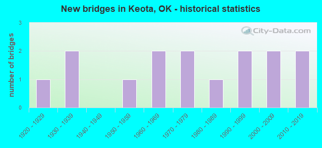
- New bridges - historical statistics
- 11920-1929
- 21930-1939
- 11950-1959
- 21960-1969
- 21970-1979
- 11980-1989
- 21990-1999
- 22000-2009
- 22010-2019


- Bridge Condition - Deck
- 66.7%Satisfactory
- 33.3%Fair

- Bridge Condition - Superstructure
- 16.7%Very good
- 33.3%Satisfactory
- 50.0%Fair

- Bridge Condition - Substructure
- 66.7%Satisfactory
- 16.7%Fair
- 16.7%Poor

- Bridge Condition - Channel
- 6.7%Excellent
- 13.3%Very good
- 53.3%Good
- 13.3%Satisfactory
- 13.3%Fair

- Bridge Condition - Culverts
- 11.1%Excellent
- 11.1%Very good
- 44.4%Good
- 33.3%Satisfactory
Find on map >> Show street view
Structure Number: 1815, Location: 4.1 E JCT SH-26 (Lat: 35.260439, Lng: -94.891811), Route carried "on" structure: State highway 9, Year Built: 1927, Year Reconstructed: 1943, Status: Open, Structure Length: 0.70m (2.30ft), Average Daily Traffic: 2,800 (year 2020), Truck Traffic: 16%, Average Future Daily Traffic: 4,480 (year 2040), Design Load: H 20, Features Intersected: CREEK
Minimum Vertical Clearance: 30+ m (98+ ft), Kilometerpoint: 32.758, Lanes on structure: 2, Base Highway Network: Yes, Owner: State Highway Agency, Approaching Roadway Width: 9.8m (32.2ft), Material/Design: Concrete, Design/Construction: Culvert, Number Of Spans In Main Unit: 2, Length of Maximum Span: 3.0m (9.8ft)
Condition: Channel: Good, Culverts: Good, Operating Rating: 90.7 metric tons, Method Used To Determine Operating Rating: Load Factor (LF), Inventory Rating: 59.0 metric tons, Method Used To Determine Inventory Rating: Load Factor (LF), Structural Evaluation: Better than present minimum criteria, Waterway Adequacy: Equal to present minimum criteria, Approach Roadway Alignment: Equal to present desirable criteria, Length Of Structure Improvement: 0.67m (2.20ft), Designated Inspection Frequency: Every 24 months, Inspection Date: November 2020, Bridge Improvement Cost: $230,000, Roadway Improvement Cost: $380,000, Total Project Cost: $644,000 ( Estimate for 2015)
Find on map >> Show street view
Structure Number: 6272, Location: 2.5S 0.5E OF KEOTA (Lat: 35.217022, Lng: -94.911000), Route carried "on" structure: County highway E1240, Year Built: 1938, Status: Posted for load, Structure Length: 1.08m (3.54ft), Average Daily Traffic: 40 (year 2020), Truck Traffic: 10%, Average Future Daily Traffic: 64 (year 2040), Design Load: HS 20, Features Intersected: CREEK
Minimum Vertical Clearance: 30+ m (98+ ft), Kilometerpoint: 0.805, Lanes on structure: 2, Owner: County Highway Agency, Approaching Roadway Width: 9.1m (29.9ft), Material/Design: Concrete, Design/Construction: Slab, Number Of Spans In Main Unit: 3, Length of Maximum Span: 3.0m (9.8ft), Curb or Sidewalk Widths: Left: 0.3m (1.0ft), Right: 0.3m (1.0ft), Curb-To-Curb Width: 7.3m (24.0ft), Out-to-Out Width: 7.9m (25.9ft)
Condition: Deck: Fair, Superstructure: Fair, Substructure: Fair, Channel: Satisfactory, Operating Rating: 24.2 metric tons, Method Used To Determine Operating Rating: Load Factor (LF), Inventory Rating: 14.5 metric tons, Method Used To Determine Inventory Rating: Load Factor (LF), Structural Evaluation: Meets minimum limits, Deck Geometry: Equal to present minimum criteria, Waterway Adequacy: Somewhat better than minimum adequacy, Approach Roadway Alignment: Somewhat better than minimum adequacy, Bridge Posting: Required (Relationship of Operating Rating to Maximum Legal Load: 30.0 - 39.9% below), Length Of Structure Improvement: 3.52m (11.55ft), Designated Inspection Frequency: Every 24 months, Inspection Date: April 2020, Bridge Improvement Cost: $180,000, Roadway Improvement Cost: $99,000, Total Project Cost: $285,000 ( Estimate for 2015), Deck Structure Type: Concrete Cast-file-Place, Wearing Surface/Protective System: Wearing Surface: Bituminous
Find on map >> Show street view
Structure Number: 6323, Location: 2S; OF KEOTA (Lat: 35.225994, Lng: -94.920408), Route carried "on" structure: County highway N4550, Year Built: 1938, Status: Posted for load, Structure Length: 1.46m (4.79ft), Average Daily Traffic: 100 (year 2020), Truck Traffic: 10%, Average Future Daily Traffic: 160 (year 2040), Design Load: HS 20, Features Intersected: CACHE CREEK
Minimum Vertical Clearance: 30+ m (98+ ft), Kilometerpoint: 0.644, Lanes on structure: 2, Owner: County Highway Agency, Approaching Roadway Width: 9.1m (29.9ft), Material/Design: Concrete, Design/Construction: Slab, Number Of Spans In Main Unit: 4, Length of Maximum Span: 3.0m (9.8ft), Curb or Sidewalk Widths: Left: 0.3m (1.0ft), Right: 0.3m (1.0ft), Curb-To-Curb Width: 6.7m (22.0ft), Out-to-Out Width: 7.9m (25.9ft)
Condition: Deck: Fair, Superstructure: Fair, Substructure: Poor, Channel: Fair, Operating Rating: 21.9 metric tons, Method Used To Determine Operating Rating: Load Factor (LF), Inventory Rating: 13.1 metric tons, Method Used To Determine Inventory Rating: Load Factor (LF), Structural Evaluation: Meets minimum limits, Deck Geometry: Somewhat better than minimum adequacy, Waterway Adequacy: Somewhat better than minimum adequacy, Approach Roadway Alignment: Somewhat better than minimum adequacy, Bridge Posting: Required (Relationship of Operating Rating to Maximum Legal Load: > 39.9% below), Length Of Structure Improvement: 3.98m (13.06ft), Designated Inspection Frequency: Every 24 months, Inspection Date: April 2020, Bridge Improvement Cost: $203,000, Roadway Improvement Cost: $112,000, Total Project Cost: $323,000 ( Estimate for 2015), Deck Structure Type: Concrete Cast-file-Place, Wearing Surface/Protective System: Wearing Surface: Bituminous
Find on map >> Show street view
Structure Number: 12749, Location: 2.4 S JCT SH-9 (Lat: 35.223219, Lng: -94.955772), Route carried "on" structure: State highway 26, Year Built: 1952, Status: Open, Structure Length: 1.04m (3.41ft), Average Daily Traffic: 950 (year 2020), Truck Traffic: 15%, Average Future Daily Traffic: 1,520 (year 2040), Design Load: HS 20, Features Intersected: NO NAME CREEK
Minimum Vertical Clearance: 30+ m (98+ ft), Kilometerpoint: 9.075, Lanes on structure: 2, Owner: State Highway Agency, Approaching Roadway Width: 9.1m (29.9ft), Material/Design: Concrete, Design/Construction: Culvert, Number Of Spans In Main Unit: 3, Length of Maximum Span: 3.0m (9.8ft), Curb-To-Curb Width: 9.8m (32.2ft), Out-to-Out Width: 10.5m (34.4ft)
Condition: Channel: Good, Culverts: Satisfactory, Operating Rating: 54.4 metric tons, Method Used To Determine Operating Rating: Load Factor (LF), Inventory Rating: 32.7 metric tons, Method Used To Determine Inventory Rating: Load Factor (LF), Structural Evaluation: Equal to present minimum criteria, Deck Geometry: Equal to present minimum criteria, Waterway Adequacy: Equal to present minimum criteria, Approach Roadway Alignment: Equal to present desirable criteria, Length Of Structure Improvement: 1.01m (3.31ft), Designated Inspection Frequency: Every 24 months, Inspection Date: November 2020, Bridge Improvement Cost: $230,000, Roadway Improvement Cost: $380,000, Total Project Cost: $644,000 ( Estimate for 2015)
Find on map >> Show street view
Structure Number: 17061, Location: 2.3N; .2E OF KEOTA (Lat: 35.288739, Lng: -94.915836), Route carried "on" structure: County highway N4553, Year Built: 1968, Status: Open, Structure Length: 0.69m (2.26ft), Average Daily Traffic: 100 (year 2020), Truck Traffic: 10%, Average Future Daily Traffic: 160 (year 2040), Design Load: HS 20, Features Intersected: CREEK
Minimum Vertical Clearance: 30+ m (98+ ft), Kilometerpoint: 0.483, Lanes on structure: 2, Owner: County Highway Agency, Approaching Roadway Width: 7.9m (25.9ft), Material/Design: Concrete, Design/Construction: Culvert, Number Of Spans In Main Unit: 2, Length of Maximum Span: 3.0m (9.8ft), Curb or Sidewalk Widths: Left: 0.3m (1.0ft), Right: 0.3m (1.0ft)
Condition: Channel: Good, Culverts: Good, Operating Rating: 42.5 metric tons, Method Used To Determine Operating Rating: Load Factor (LF), Inventory Rating: 32.8 metric tons, Method Used To Determine Inventory Rating: Load Factor (LF), Structural Evaluation: Better than present minimum criteria, Waterway Adequacy: Better than present minimum criteria, Approach Roadway Alignment: Better than present minimum criteria, Length Of Structure Improvement: 2.79m (9.15ft), Designated Inspection Frequency: Every 24 months, Inspection Date: June 2021, Bridge Improvement Cost: $100,000, Roadway Improvement Cost: $75,000, Total Project Cost: $225,000 ( Estimate for 2015)
Find on map >> Show street view
Structure Number: 17356, Location: 3.1 MI NW OF SH 9 (Lat: 35.297856, Lng: -94.932264), Route carried "on" structure: County highway 3144C, Year Built: 1968, Status: Posted for load, Structure Length: 16.25m (53.31ft), Average Daily Traffic: 600 (year 2020), Truck Traffic: 15%, Average Future Daily Traffic: 960 (year 2040), Design Load: HS 20, Features Intersected: SAN BOIS CREEK
Minimum Vertical Clearance: 30+ m (98+ ft), Kilometerpoint: 4.987, Lanes on structure: 2, Owner: County Highway Agency, Approaching Roadway Width: 9.1m (29.9ft), Material/Design: Steel continuous, Design/Construction: Stringer/Multi-beam, Number Of Spans In Main Unit: 3, Length of Maximum Span: 73.2m (240.2ft), Curb or Sidewalk Widths: Left: 0.5m (1.6ft), Right: 0.5m (1.6ft), Curb-To-Curb Width: 7.4m (24.3ft), Out-to-Out Width: 8.3m (27.2ft)
Condition: Deck: Satisfactory, Superstructure: Satisfactory, Substructure: Satisfactory, Channel: Very good, Operating Rating: 8.0 metric tons, Method Used To Determine Operating Rating: Load Factor (LF), Inventory Rating: 4.9 metric tons, Method Used To Determine Inventory Rating: Load Factor (LF), Structural Evaluation: High priority of replacement, Deck Geometry: Meets minimum limits, Waterway Adequacy: Equal to present desirable criteria, Approach Roadway Alignment: Better than present minimum criteria, Bridge Posting: Required (Relationship of Operating Rating to Maximum Legal Load: > 39.9% below), Length Of Structure Improvement: 16.25m (53.31ft), Designated Inspection Frequency: Every 24 months, Underwater Inspection Frequency: Every 60 months, Inspection Date: June 2021, Underwater Inspection Date: July 2020, Bridge Improvement Cost: $830,000, Roadway Improvement Cost: $456,000, Total Project Cost: $1,307,000 ( Estimate for 2015), Deck Structure Type: Concrete Cast-file-Place, Wearing Surface/Protective System: Wearing Surface: Monolithic Concrete
Find on map >> Show street view
Structure Number: 17911, Location: 17.7 E JCT SH-2 (Lat: 35.258783, Lng: -94.937767), Route carried "on" structure: State highway 9, Year Built: 1970, Status: Open, Structure Length: 5.55m (18.21ft), Average Daily Traffic: 3,500 (year 2020), Truck Traffic: 16%, Average Future Daily Traffic: 5,600 (year 2040), Design Load: HS 20, Features Intersected: OTTER CREEK
Minimum Vertical Clearance: 30+ m (98+ ft), Kilometerpoint: 44.693, Lanes on structure: 2, Base Highway Network: Yes, Owner: State Highway Agency, Approaching Roadway Width: 13.4m (44.0ft), Material/Design: Steel continuous, Design/Construction: Stringer/Multi-beam, Number Of Spans In Main Unit: 3, Length of Maximum Span: 21.3m (69.9ft), Curb-To-Curb Width: 13.4m (44.0ft), Out-to-Out Width: 14.0m (45.9ft)
Condition: Deck: Satisfactory, Superstructure: Very good, Substructure: Satisfactory, Channel: Good, Operating Rating: 52.6 metric tons, Method Used To Determine Operating Rating: Load Factor (LF), Inventory Rating: 31.8 metric tons, Method Used To Determine Inventory Rating: Load Factor (LF), Structural Evaluation: Equal to present minimum criteria, Deck Geometry: Better than present minimum criteria, Waterway Adequacy: Better than present minimum criteria, Approach Roadway Alignment: Equal to present desirable criteria, Length Of Structure Improvement: 8.56m (28.08ft), Designated Inspection Frequency: Every 24 months, Inspection Date: November 2020, Bridge Improvement Cost: $700,000, Roadway Improvement Cost: $1,155,000, Total Project Cost: $1,960,000 ( Estimate for 2015), Deck Structure Type: Concrete Cast-file-Place, Wearing Surface/Protective System: Wearing Surface: Monolithic Concrete
Find on map >> Show street view
Structure Number: 17954, Location: 15.7 MI E OF JCT SH2 (Lat: 35.259239, Lng: -94.970814), Route carried "on" structure: State highway 9, Year Built: 1970, Status: Open, Structure Length: 16.31m (53.51ft), Average Daily Traffic: 3,700 (year 2020), Truck Traffic: 16%, Average Future Daily Traffic: 5,920 (year 2040), Design Load: HS 20, Features Intersected: SANS BOIS CREEK
Minimum Vertical Clearance: 30+ m (98+ ft), Kilometerpoint: 24.715, Lanes on structure: 2, Base Highway Network: Yes, Owner: State Highway Agency, Approaching Roadway Width: 13.4m (44.0ft), Navigation Control: Yes ( Vertical Clearance: 9.1m (29.9ft), Horizontal Clearance: 68.5m (224.7ft)), Material/Design: Steel continuous, Design/Construction: Stringer/Multi-beam, Number Of Spans In Main Unit: 3, Length of Maximum Span: 73.8m (242.1ft), Curb or Sidewalk Widths: Left: 0.5m (1.6ft), Right: 0.5m (1.6ft), Curb-To-Curb Width: 8.5m (27.9ft), Out-to-Out Width: 10.1m (33.1ft)
Condition: Deck: Satisfactory, Superstructure: Fair, Substructure: Satisfactory, Channel: Good, Operating Rating: 60.8 metric tons, Method Used To Determine Operating Rating: Load Factor (LF), Inventory Rating: 36.3 metric tons, Method Used To Determine Inventory Rating: Load Factor (LF), Structural Evaluation: Somewhat better than minimum adequacy, Deck Geometry: Meets minimum limits, Waterway Adequacy: Equal to present desirable criteria, Approach Roadway Alignment: Equal to present minimum criteria, Length Of Structure Improvement: 16.31m (53.51ft), Designated Inspection Frequency: Every 24 months, Inspection Date: December 2020, Bridge Improvement Cost: $3,200,000, Roadway Improvement Cost: $4,500,000, Total Project Cost: $8,136,000 ( Estimate for 2015), Deck Structure Type: Concrete Cast-file-Place, Wearing Surface/Protective System: Wearing Surface: Monolithic Concrete
Find on map >> Show street view
Structure Number: 22355, Location: .5 S OF KEOTA (Lat: 35.250847, Lng: -94.920297), Route carried "on" structure: County highway N4550, Year Built: 1989, Status: Open, Structure Length: 4.30m (14.11ft), Average Daily Traffic: 100 (year 2020), Truck Traffic: 10%, Average Future Daily Traffic: 160 (year 2040), Design Load: HS 20, Features Intersected: OTTER CREEK
Minimum Vertical Clearance: 30+ m (98+ ft), Kilometerpoint: 1.287, Lanes on structure: 2, Owner: County Highway Agency, Approaching Roadway Width: 11.6m (38.1ft), Skew: 3 degrees, Material/Design: Prestressed concrete, Design/Construction: Tee Beam, Number Of Spans In Main Unit: 3, Length of Maximum Span: 15.2m (49.9ft), Curb or Sidewalk Widths: Left: 0.3m (1.0ft), Right: 0.3m (1.0ft), Curb-To-Curb Width: 9.8m (32.2ft), Out-to-Out Width: 10.4m (34.1ft)
Condition: Deck: Satisfactory, Superstructure: Satisfactory, Substructure: Satisfactory, Channel: Good, Operating Rating: 39.0 metric tons, Method Used To Determine Operating Rating: Load Factor (LF), Inventory Rating: 23.4 metric tons, Method Used To Determine Inventory Rating: Load Factor (LF), Structural Evaluation: Equal to present minimum criteria, Deck Geometry: Equal to present desirable criteria, Waterway Adequacy: Better than present minimum criteria, Approach Roadway Alignment: Better than present minimum criteria, Length Of Structure Improvement: 7.45m (24.44ft), Designated Inspection Frequency: Every 24 months, Inspection Date: June 2021, Bridge Improvement Cost: $380,000, Roadway Improvement Cost: $209,000, Total Project Cost: $648,000 ( Estimate for 2015), Deck Structure Type: Concrete Precast Panels, Wearing Surface/Protective System: Wearing Surface: Bituminous
Find on map >> Show street view
Structure Number: 25605, Location: 0.3 MI S OF SH 9 (Lat: 35.255097, Lng: -94.902631), Route carried "on" structure: County highway 3119, Year Built: 1998, Status: Open, Structure Length: 0.79m (2.59ft), Average Daily Traffic: 100 (year 2020), Truck Traffic: 15%, Average Future Daily Traffic: 160 (year 2040), Design Load: HS 20, Features Intersected: CREEK
Minimum Vertical Clearance: 30+ m (98+ ft), Kilometerpoint: 4.344, Lanes on structure: 2, Owner: County Highway Agency, Approaching Roadway Width: 5.5m (18.0ft), Material/Design: Concrete, Design/Construction: Culvert, Number Of Spans In Main Unit: 3, Length of Maximum Span: 2.4m (7.9ft), Curb or Sidewalk Widths: Left: 0.5m (1.6ft), Right: 0.5m (1.6ft), Curb-To-Curb Width: 7.0m (23.0ft), Out-to-Out Width: 7.9m (25.9ft)
Condition: Channel: Good, Culverts: Good, Operating Rating: 36.2 metric tons, Method Used To Determine Operating Rating: Load Factor (LF), Inventory Rating: 28.0 metric tons, Method Used To Determine Inventory Rating: Load Factor (LF), Structural Evaluation: Better than present minimum criteria, Deck Geometry: Somewhat better than minimum adequacy, Waterway Adequacy: Equal to present desirable criteria, Approach Roadway Alignment: Equal to present desirable criteria, Length Of Structure Improvement: 3.05m (10.01ft), Designated Inspection Frequency: Every 24 months, Inspection Date: April 2020, Bridge Improvement Cost: $100,000, Roadway Improvement Cost: $75,000, Total Project Cost: $225,000 ( Estimate for 2015)
Find on map >> Show street view
Structure Number: 27412, Location: 1E 1.5S OF KEOTA (Lat: 35.238889, Lng: -94.902778), Route carried "on" structure: County highway N4560, Year Built: 1994, Status: Open, Structure Length: 1.40m (4.59ft), Average Daily Traffic: 100 (year 2020), Truck Traffic: 10%, Average Future Daily Traffic: 160 (year 2040), Design Load: HS 20, Features Intersected: CREEK
Minimum Vertical Clearance: 30+ m (98+ ft), Kilometerpoint: 0.805, Lanes on structure: 2, Owner: County Highway Agency, Approaching Roadway Width: 7.9m (25.9ft), Material/Design: Concrete, Design/Construction: Culvert, Number Of Spans In Main Unit: 3, Length of Maximum Span: 5.2m (17.1ft), Curb or Sidewalk Widths: Left: 0.3m (1.0ft), Right: 0.3m (1.0ft), Curb-To-Curb Width: 7.9m (25.9ft), Out-to-Out Width: 8.5m (27.9ft)
Condition: Channel: Good, Culverts: Satisfactory, Operating Rating: 36.2 metric tons, Method Used To Determine Operating Rating: Load Factor (LF), Inventory Rating: 28.0 metric tons, Method Used To Determine Inventory Rating: Load Factor (LF), Structural Evaluation: Equal to present minimum criteria, Deck Geometry: Equal to present minimum criteria, Waterway Adequacy: Equal to present desirable criteria, Approach Roadway Alignment: Better than present minimum criteria, Length Of Structure Improvement: 3.05m (10.01ft), Designated Inspection Frequency: Every 24 months, Inspection Date: April 2020, Bridge Improvement Cost: $100,000, Roadway Improvement Cost: $75,000, Total Project Cost: $225,000 ( Estimate for 2015), Wearing Surface/Protective System: Wearing Surface: Bituminous
Find on map >> Show street view
Structure Number: 28023, Location: 1.7S; 1.7E OF KEOTA (Lat: 35.231481, Lng: -94.887842), Route carried "on" structure: County highway E1230, Year Built: 2003, Status: Posted for load, Structure Length: 1.30m (4.27ft), Average Daily Traffic: 100 (year 2020), Truck Traffic: 10%, Average Future Daily Traffic: 160 (year 2040), Design Load: HS 20, Features Intersected: OTTER CREEK TRIBUTARY
Minimum Vertical Clearance: 30+ m (98+ ft), Kilometerpoint: 1.287, Lanes on structure: 2, Owner: County Highway Agency, Approaching Roadway Width: 7.3m (24.0ft), Skew: 6 degrees, Material/Design: Concrete, Design/Construction: Culvert, Number Of Spans In Main Unit: 3, Length of Maximum Span: 3.4m (11.2ft), Curb or Sidewalk Widths: Left: 0.3m (1.0ft), Right: 0.3m (1.0ft), Curb-To-Curb Width: 7.9m (25.9ft), Out-to-Out Width: 8.5m (27.9ft)
Condition: Channel: Fair, Culverts: Satisfactory, Operating Rating: 30.5 metric tons, Method Used To Determine Operating Rating: Load Factor (LF), Inventory Rating: 23.5 metric tons, Method Used To Determine Inventory Rating: Load Factor (LF), Structural Evaluation: Equal to present minimum criteria, Deck Geometry: Equal to present minimum criteria, Waterway Adequacy: Equal to present desirable criteria, Approach Roadway Alignment: Equal to present minimum criteria, Bridge Posting: Required (Relationship of Operating Rating to Maximum Legal Load: 0.1 - 9.9% below), Length Of Structure Improvement: 1.22m (4.00ft), Designated Inspection Frequency: Every 24 months, Inspection Date: April 2020, Bridge Improvement Cost: $400,000, Roadway Improvement Cost: $600,000, Total Project Cost: $1,150,000 ( Estimate for 2015), Deck Structure Type: Concrete Cast-file-Place, Wearing Surface/Protective System: Wearing Surface: Integral Concrete, Deck Protection: Other
Find on map >> Show street view
Structure Number: 29702, Location: .6S; .3E OF SH9;KEOTA (Lat: 35.245833, Lng: -94.917222), Route carried "on" structure: County highway E1220, Year Built: 2009, Status: Open, Structure Length: 1.86m (6.10ft), Average Daily Traffic: 100 (year 2020), Truck Traffic: 10%, Average Future Daily Traffic: 160 (year 2040), Design Load: HS 20, Features Intersected: OTTER CREEK
Minimum Vertical Clearance: 30+ m (98+ ft), Kilometerpoint: 0.322, Lanes on structure: 2, Owner: County Highway Agency, Approaching Roadway Width: 8.5m (27.9ft), Skew: 3 degrees, Material/Design: Concrete, Design/Construction: Culvert, Number Of Spans In Main Unit: 4, Length of Maximum Span: 4.4m (14.4ft), Curb or Sidewalk Widths: Left: 0.3m (1.0ft), Right: 0.3m (1.0ft)
Condition: Channel: Satisfactory, Culverts: Good, Operating Rating: 37.6 metric tons, Method Used To Determine Operating Rating: Load Factor (LF), Inventory Rating: 29.0 metric tons, Method Used To Determine Inventory Rating: Load Factor (LF), Structural Evaluation: Better than present minimum criteria, Waterway Adequacy: Better than present minimum criteria, Approach Roadway Alignment: Better than present minimum criteria, Designated Inspection Frequency: Every 24 months, Inspection Date: April 2020, Total Project Cost: $225,000
Find on map >> Show street view
Structure Number: 30212, Location: .7S .7W OF KEOTA (Lat: 35.246111, Lng: -94.935000), Route carried "on" structure: County highway E1220, Year Built: 2014, Status: Open, Structure Length: 1.97m (6.46ft), Average Daily Traffic: 250 (year 2020), Truck Traffic: 10%, Average Future Daily Traffic: 160 (year 2040), Design Load: HS 20, Features Intersected: OTTER CREEK TRIB.
Minimum Vertical Clearance: 30+ m (98+ ft), Kilometerpoint: 0.322, Lanes on structure: 2, Owner: County Highway Agency, Approaching Roadway Width: 7.9m (25.9ft), Material/Design: Concrete, Design/Construction: Culvert, Number Of Spans In Main Unit: 3, Length of Maximum Span: 6.1m (20.0ft), Curb or Sidewalk Widths: Left: 0.3m (1.0ft), Right: 0.3m (1.0ft)
Condition: Channel: Very good, Culverts: Very good, Operating Rating: 50.6 metric tons, Method Used To Determine Operating Rating: Load Factor (LF), Inventory Rating: 38.8 metric tons, Method Used To Determine Inventory Rating: Load Factor (LF), Structural Evaluation: Equal to present desirable criteria, Waterway Adequacy: Equal to present desirable criteria, Approach Roadway Alignment: Equal to present desirable criteria, Designated Inspection Frequency: Every 24 months, Inspection Date: April 2020, Total Project Cost: $225,000, Wearing Surface/Protective System: Wearing Surface: Gravel
Find on map >> Show street view
Structure Number: 31248, Location: 2E .7N of SH9/SH26 (Lat: 35.267778, Lng: -94.920283), Route carried "on" structure: County highway N4550, Year Built: 2019, Status: Open, Structure Length: 1.97m (6.46ft), Average Daily Traffic: 600 (year 2020), Truck Traffic: 15%, Average Future Daily Traffic: 960 (year 2040), Design Load: HS 20, Features Intersected: ELM BRANCH
Minimum Vertical Clearance: 30.45m (99.90ft), Kilometerpoint: 1.553, Lanes on structure: 2, Owner: County Highway Agency, Approaching Roadway Width: 7.3m (24.0ft), Material/Design: Concrete, Design/Construction: Culvert, Number Of Spans In Main Unit: 3, Length of Maximum Span: 6.1m (20.0ft), Curb-To-Curb Width: 6.7m (22.0ft), Out-to-Out Width: 8.5m (27.9ft)
Condition: Channel: Excellent, Culverts: Excellent, Operating Rating: 52.5 metric tons, Method Used To Determine Operating Rating: Load Factor (LF), Inventory Rating: 40.5 metric tons, Method Used To Determine Inventory Rating: Load Factor (LF), Structural Evaluation: Superior to present desirable criteria, Deck Geometry: Meets minimum limits, Waterway Adequacy: Equal to present desirable criteria, Approach Roadway Alignment: Equal to present desirable criteria, Designated Inspection Frequency: Every 24 months, Inspection Date: April 2020, Deck Structure Type: Concrete Cast-file-Place, Wearing Surface/Protective System: Wearing Surface: Monolithic Concrete