Bridge Statistics for Kerhonkson, New York (NY)
Condition, Traffic, Stress, Structural Evaluation, Project Costs
- National Bridge Inventory (NBI) Statistics
- 10Number of bridges
- 49ft / 15.3mTotal length
- $10,198,000Total costs
- 5,129Total average daily traffic
- 327Total average daily truck traffic
- 7,181Total future (year 2034) average daily traffic
- National Bridge Inventory (NBI) Registered Bridges for Kerhonkson
- No street view available for this location
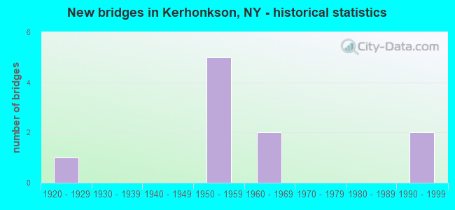
- New bridges - historical statistics
- 11920-1929
- 51950-1959
- 21960-1969
- 21990-1999

- Reconstructed bridges - Historical Statistics
- 11980-1989
- 51990-1999

- Bridge Condition - Deck
- 10.0%Good
- 20.0%Satisfactory
- 60.0%Fair
- 10.0%Poor

- Bridge Condition - Superstructure
- 40.0%Good
- 10.0%Satisfactory
- 10.0%Fair
- 40.0%Poor

- Bridge Condition - Substructure
- 30.0%Satisfactory
- 50.0%Fair
- 10.0%Poor
- 10.0%Critical

- Bridge Condition - Channel
- 40.0%Satisfactory
- 40.0%Fair
- 10.0%Poor
- 10.0%Serious
Find on map >> Show street view
Structure Number: 222445, Location: 2.2 MI SE OF KERHONKSON (Lat: 41.749425, Lng: -74.276222), Route carried "on" structure: Other road , Year Built: 1955, Status: Posted for load, Structure Length: 1.28m (4.20ft), Average Daily Traffic: 8 (year 2018), Truck Traffic: 4%, Average Future Daily Traffic: 11 (year 2038), Features Intersected: STONY KILL, Facility Carried by Structure: BRIDGE ROAD
Minimum Vertical Clearance: 30+ m (98+ ft), Kilometerpoint: 0.129, Lanes on structure: 1, Owner: Town or Township Highway Agency, Approaching Roadway Width: 4.9m (16.1ft), Skew: 1 degrees, Material/Design: Steel, Design/Construction: Stringer/Multi-beam, Number Of Spans In Main Unit: 1, Length of Maximum Span: 11.8m (38.7ft), Curb-To-Curb Width: 4.2m (13.8ft), Out-to-Out Width: 4.8m (15.7ft)
Condition: Deck: Poor, Superstructure: Poor, Substructure: Fair, Channel: Poor, Operating Rating: 32.7 metric tons, Method Used To Determine Operating Rating: Load Factor (LF), Inventory Rating: 19.1 metric tons, Method Used To Determine Inventory Rating: Load Factor (LF), Structural Evaluation: Meets minimum limits, Deck Geometry: Somewhat better than minimum adequacy, Waterway Adequacy: Meets minimum limits, Approach Roadway Alignment: Somewhat better than minimum adequacy, Bridge Posting: Required (Relationship of Operating Rating to Maximum Legal Load: > 39.9% below), Length Of Structure Improvement: 1.28m (4.20ft), Designated Inspection Frequency: Every 12 months, Inspection Date: April 2021, Bridge Improvement Cost: $316,000, Roadway Improvement Cost: $185,000, Total Project Cost: $501,000 ( Estimate for 2021), Deck Structure Type: Wood or Timber, Wearing Surface/Protective System: Wearing Surface: Bituminous
Find on map >> Show street view
Structure Number: 222446, Location: 0.8 MI NE OF PATAUKUNK (Lat: 41.795767, Lng: -74.291550), Route carried "on" structure: Other road , Year Built: 1929, Year Reconstructed: 1988, Status: Posted for load, Structure Length: 1.52m (4.99ft), Average Daily Traffic: 564 (year 2018), Truck Traffic: 8%, Average Future Daily Traffic: 790 (year 2038), Features Intersected: FALLS MILL BROOK, Facility Carried by Structure: BOICE MILL ROAD
Minimum Vertical Clearance: 30+ m (98+ ft), Kilometerpoint: 2.220, Lanes on structure: 2, Owner: Town or Township Highway Agency, Approaching Roadway Width: 4.9m (16.1ft), Skew: 3 degrees, Material/Design: Steel, Design/Construction: Stringer/Multi-beam, Number Of Spans In Main Unit: 1, Length of Maximum Span: 14.3m (46.9ft), Curb-To-Curb Width: 5.8m (19.0ft), Out-to-Out Width: 6.1m (20.0ft)
Condition: Deck: Fair, Superstructure: Poor, Substructure: Poor, Channel: Satisfactory, Operating Rating: 10.7 metric tons, Method Used To Determine Operating Rating: Load and Resistance Factor Rating (LRFR) rating reported by rating factor(RF) method using HL-93 loadings, Inventory Rating: 8.1 metric tons, Method Used To Determine Inventory Rating: Load and Resistance Factor Rating (LRFR) rating reported by rating factor(RF) method using HL-93 loadings, Structural Evaluation: High priority of corrective action, Deck Geometry: High priority of replacement, Waterway Adequacy: Meets minimum limits, Approach Roadway Alignment: Meets minimum limits, Bridge Posting: Required (Relationship of Operating Rating to Maximum Legal Load: > 39.9% below), Length Of Structure Improvement: 1.52m (4.99ft), Designated Inspection Frequency: Every 12 months, Inspection Date: May 2021, Bridge Improvement Cost: $378,000, Roadway Improvement Cost: $221,000, Total Project Cost: $599,000 ( Estimate for 2021), Deck Structure Type: Wood or Timber, Wearing Surface/Protective System: Wearing Surface: Bituminous
Find on map >> Show street view
Structure Number: 222447, Location: 1.8 MI NW OF PATAUKUNK (Lat: 41.814947, Lng: -74.320928), Route carried "on" structure: Other road , Year Built: 1955, Year Reconstructed: 2002, Status: Open, Structure Length: 1.31m (4.30ft), Average Daily Traffic: 65 (year 2019), Truck Traffic: 7%, Average Future Daily Traffic: 91 (year 2039), Features Intersected: MOMBACCUS CREEK, Facility Carried by Structure: WATER FALLS ROAD
Minimum Vertical Clearance: 30+ m (98+ ft), Kilometerpoint: 0.064, Lanes on structure: 1, Owner: Town or Township Highway Agency, Approaching Roadway Width: 4.0m (13.1ft), Material/Design: Steel, Design/Construction: Stringer/Multi-beam, Number Of Spans In Main Unit: 1, Length of Maximum Span: 12.4m (40.7ft), Curb-To-Curb Width: 4.7m (15.4ft), Out-to-Out Width: 4.9m (16.1ft)
Condition: Deck: Fair, Superstructure: Poor, Substructure: Fair, Channel: Fair, Operating Rating: 30.1 metric tons, Method Used To Determine Operating Rating: Load and Resistance Factor Rating (LRFR) rating reported by rating factor(RF) method using HL-93 loadings, Inventory Rating: 23.3 metric tons, Method Used To Determine Inventory Rating: Load and Resistance Factor Rating (LRFR) rating reported by rating factor(RF) method using HL-93 loadings, Structural Evaluation: Meets minimum limits, Deck Geometry: Better than present minimum criteria, Waterway Adequacy: Meets minimum limits, Approach Roadway Alignment: Somewhat better than minimum adequacy, Length Of Structure Improvement: 1.31m (4.30ft), Designated Inspection Frequency: Every 24 months, Inspection Date: May 2021, Bridge Improvement Cost: $344,000, Roadway Improvement Cost: $201,000, Total Project Cost: $545,000 ( Estimate for 2021), Deck Structure Type: Wood or Timber, Wearing Surface/Protective System: Wearing Surface: Wood or Timber
Find on map >> Show street view
Structure Number: 334645, Location: 2.1 MILE E OF PATAUKUNK (Lat: 41.792142, Lng: -74.263656), Route carried "on" structure: Other road , Year Built: 1994, Status: Open, Structure Length: 1.65m (5.41ft), Average Daily Traffic: 2,035 (year 2019), Truck Traffic: 5%, Average Future Daily Traffic: 2,849 (year 2039), Design Load: HS 20, Features Intersected: FALLS MILL BROOK, Facility Carried by Structure: QUEENS HIGHWAY
Minimum Vertical Clearance: 30+ m (98+ ft), Kilometerpoint: 0.322, Lanes on structure: 2, Owner: County Highway Agency, Approaching Roadway Width: 7.5m (24.6ft), Skew: 3 degrees, Material/Design: Steel, Design/Construction: Stringer/Multi-beam, Number Of Spans In Main Unit: 1, Length of Maximum Span: 16.1m (52.8ft), Curb-To-Curb Width: 7.5m (24.6ft), Out-to-Out Width: 8.3m (27.2ft)
Condition: Deck: Satisfactory, Superstructure: Good, Substructure: Satisfactory, Channel: Fair, Operating Rating: 91.6 metric tons, Method Used To Determine Operating Rating: Load Factor (LF), Inventory Rating: 54.4 metric tons, Method Used To Determine Inventory Rating: Load Factor (LF), Structural Evaluation: Equal to present minimum criteria, Deck Geometry: High priority of replacement, Waterway Adequacy: Meets minimum limits, Approach Roadway Alignment: Equal to present desirable criteria, Length Of Structure Improvement: 1.64m (5.38ft), Designated Inspection Frequency: Every 24 months, Inspection Date: October 2020, Bridge Improvement Cost: $872,000, Roadway Improvement Cost: $511,000, Total Project Cost: $1,383,000 ( Estimate for 2021), Deck Structure Type: Corrugated Steel, Wearing Surface/Protective System: Wearing Surface: Bituminous
Find on map >> Show street view
Structure Number: 334665, Location: 1.8 MI SE OF KERHONKSON (Lat: 41.753839, Lng: -74.274867), Route carried "on" structure: County highway , Year Built: 1955, Year Reconstructed: 2004, Status: Open, Structure Length: 1.52m (4.99ft), Average Daily Traffic: 405 (year 2019), Truck Traffic: 5%, Average Future Daily Traffic: 567 (year 2039), Features Intersected: STONY KILL, Facility Carried by Structure: COUNTY ROAD 27
Minimum Vertical Clearance: 30+ m (98+ ft), Kilometerpoint: 0.660, Lanes on structure: 2, Owner: County Highway Agency, Approaching Roadway Width: 5.8m (19.0ft), Skew: 3 degrees, Material/Design: Steel, Design/Construction: Stringer/Multi-beam, Number Of Spans In Main Unit: 1, Length of Maximum Span: 14.6m (47.9ft), Curb-To-Curb Width: 7.7m (25.3ft), Out-to-Out Width: 7.9m (25.9ft)
Condition: Deck: Fair, Superstructure: Fair, Substructure: Fair, Channel: Satisfactory, Operating Rating: 66.2 metric tons, Method Used To Determine Operating Rating: Load Factor (LF), Inventory Rating: 39.9 metric tons, Method Used To Determine Inventory Rating: Load Factor (LF), Structural Evaluation: Somewhat better than minimum adequacy, Deck Geometry: Meets minimum limits, Waterway Adequacy: Meets minimum limits, Approach Roadway Alignment: Somewhat better than minimum adequacy, Length Of Structure Improvement: 1.52m (4.99ft), Designated Inspection Frequency: Every 24 months, Inspection Date: September 2020, Bridge Improvement Cost: $753,000, Roadway Improvement Cost: $441,000, Total Project Cost: $1,195,000 ( Estimate for 2021), Deck Structure Type: Corrugated Steel, Wearing Surface/Protective System: Wearing Surface: Bituminous, Membrane: Other
Find on map >> Show street view
Structure Number: 334692, Location: 1.9 MI SE OF KERHONKSON (Lat: 41.757053, Lng: -74.267428), Route carried "on" structure: County highway , Year Built: 1990, Status: Open, Structure Length: 1.34m (4.40ft), Average Daily Traffic: 405 (year 2019), Truck Traffic: 5%, Average Future Daily Traffic: 567 (year 2039), Design Load: HS 20, Features Intersected: STONY KILL, Facility Carried by Structure: GRANITE ROAD
Minimum Vertical Clearance: 30+ m (98+ ft), Kilometerpoint: 1.480, Lanes on structure: 2, Owner: County Highway Agency, Approaching Roadway Width: 7.3m (24.0ft), Material/Design: Steel, Design/Construction: Stringer/Multi-beam, Number Of Spans In Main Unit: 1, Length of Maximum Span: 13.1m (43.0ft), Curb-To-Curb Width: 7.7m (25.3ft), Out-to-Out Width: 7.9m (25.9ft)
Condition: Deck: Satisfactory, Superstructure: Good, Substructure: Satisfactory, Channel: Satisfactory, Operating Rating: 32.4 metric tons, Method Used To Determine Operating Rating: Load and Resistance Factor Rating (LRFR) rating reported by rating factor(RF) method using HL-93 loadings, Inventory Rating: 24.9 metric tons, Method Used To Determine Inventory Rating: Load and Resistance Factor Rating (LRFR) rating reported by rating factor(RF) method using HL-93 loadings, Structural Evaluation: Equal to present minimum criteria, Deck Geometry: Meets minimum limits, Waterway Adequacy: Superior to present desirable criteria, Approach Roadway Alignment: High priority of corrective action, Length Of Structure Improvement: 1.34m (4.40ft), Designated Inspection Frequency: Every 24 months, Inspection Date: December 2020, Bridge Improvement Cost: $763,000, Roadway Improvement Cost: $447,000, Total Project Cost: $1,209,000 ( Estimate for 2021), Deck Structure Type: Wood or Timber, Wearing Surface/Protective System: Wearing Surface: Bituminous, Membrane: Other
Find on map >> Show street view
Structure Number: 334749, Location: 1.9 MI SE OF KERHONKSON (Lat: 41.751403, Lng: -74.275497), Route carried "on" structure: Other road , Year Built: 1955, Year Reconstructed: 2003, Status: Open, Structure Length: 1.28m (4.20ft), Average Daily Traffic: 8 (year 2018), Truck Traffic: 4%, Average Future Daily Traffic: 11 (year 2038), Features Intersected: STONY KILL, Facility Carried by Structure: BRIDGE ROAD
Minimum Vertical Clearance: 30+ m (98+ ft), Kilometerpoint: 0.354, Lanes on structure: 1, Owner: County Highway Agency, Approaching Roadway Width: 4.3m (14.1ft), Skew: 5 degrees, Material/Design: Steel, Design/Construction: Stringer/Multi-beam, Number Of Spans In Main Unit: 1, Length of Maximum Span: 12.5m (41.0ft), Curb-To-Curb Width: 4.0m (13.1ft), Out-to-Out Width: 4.2m (13.8ft)
Condition: Deck: Good, Superstructure: Good, Substructure: Critical, Channel: Serious, Operating Rating: 79.4 metric tons, Method Used To Determine Operating Rating: Load and Resistance Factor Rating (LRFR) rating reported by rating factor(RF) method using HL-93 loadings, Inventory Rating: 61.2 metric tons, Method Used To Determine Inventory Rating: Load and Resistance Factor Rating (LRFR) rating reported by rating factor(RF) method using HL-93 loadings, Structural Evaluation: High priority of replacement, Deck Geometry: Somewhat better than minimum adequacy, Waterway Adequacy: High priority of corrective action, Approach Roadway Alignment: Somewhat better than minimum adequacy, Length Of Structure Improvement: 1.28m (4.20ft), Designated Inspection Frequency: Every 24 months, Inspection Date: June 2020, Bridge Improvement Cost: $433,000, Roadway Improvement Cost: $254,000, Total Project Cost: $687,000 ( Estimate for 2021), Deck Structure Type: Corrugated Steel, Wearing Surface/Protective System: Wearing Surface: Bituminous, Membrane: Other
Find on map >> Show street view
Structure Number: 334752, Location: 1.6 MI E OF PATAUKUNK (Lat: 41.789428, Lng: -74.272719), Route carried "on" structure: Other road , Year Built: 1962, Year Reconstructed: 2003, Status: Open, Structure Length: 1.07m (3.51ft), Average Daily Traffic: 564 (year 2018), Truck Traffic: 8%, Average Future Daily Traffic: 790 (year 2038), Features Intersected: FALLS MILL BROOK, Facility Carried by Structure: BOICE MILL RD
Minimum Vertical Clearance: 30+ m (98+ ft), Kilometerpoint: 0.354, Lanes on structure: 2, Owner: County Highway Agency, Approaching Roadway Width: 6.7m (22.0ft), Material/Design: Steel, Design/Construction: Stringer/Multi-beam, Number Of Spans In Main Unit: 1, Length of Maximum Span: 9.8m (32.2ft), Curb-To-Curb Width: 6.4m (21.0ft), Out-to-Out Width: 6.7m (22.0ft)
Condition: Deck: Fair, Superstructure: Satisfactory, Substructure: Satisfactory, Channel: Fair, Operating Rating: 46.7 metric tons, Method Used To Determine Operating Rating: Load and Resistance Factor Rating (LRFR) rating reported by rating factor(RF) method using HL-93 loadings, Inventory Rating: 36.0 metric tons, Method Used To Determine Inventory Rating: Load and Resistance Factor Rating (LRFR) rating reported by rating factor(RF) method using HL-93 loadings, Structural Evaluation: Equal to present minimum criteria, Deck Geometry: High priority of corrective action, Waterway Adequacy: Meets minimum limits, Approach Roadway Alignment: Somewhat better than minimum adequacy, Length Of Structure Improvement: 1.06m (3.48ft), Designated Inspection Frequency: Every 24 months, Inspection Date: August 2020, Bridge Improvement Cost: $412,000, Roadway Improvement Cost: $241,000, Total Project Cost: $653,000 ( Estimate for 2021), Deck Structure Type: Corrugated Steel, Wearing Surface/Protective System: Wearing Surface: Bituminous
Find on map >> Show street view
Structure Number: 33476, Location: 0.5 MI N OF PATAUKUNK (Lat: 41.798661, Lng: -74.307511), Route carried "on" structure: County highway , Year Built: 1955, Year Reconstructed: 1996, Status: Open, Structure Length: 1.55m (5.09ft), Average Daily Traffic: 726 (year 2014), Truck Traffic: 9%, Average Future Daily Traffic: 1,016 (year 2034), Design Load: HS 20, Features Intersected: MOMBACCUS CREEK, Facility Carried by Structure: COUNTY ROAD 3
Minimum Vertical Clearance: 30+ m (98+ ft), Kilometerpoint: 0.901, Lanes on structure: 2, Owner: County Highway Agency, Approaching Roadway Width: 7.0m (23.0ft), Skew: 3 degrees, Material/Design: Steel, Design/Construction: Stringer/Multi-beam, Number Of Spans In Main Unit: 1, Length of Maximum Span: 15.2m (49.9ft), Curb-To-Curb Width: 7.1m (23.3ft), Out-to-Out Width: 7.3m (24.0ft)
Condition: Deck: Fair, Superstructure: Poor, Substructure: Fair, Channel: Fair, Operating Rating: 34.0 metric tons, Method Used To Determine Operating Rating: Load and Resistance Factor Rating (LRFR) rating reported by rating factor(RF) method using HL-93 loadings, Inventory Rating: 26.2 metric tons, Method Used To Determine Inventory Rating: Load and Resistance Factor Rating (LRFR) rating reported by rating factor(RF) method using HL-93 loadings, Structural Evaluation: Meets minimum limits, Deck Geometry: Meets minimum limits, Waterway Adequacy: Meets minimum limits, Approach Roadway Alignment: Somewhat better than minimum adequacy, Length Of Structure Improvement: 1.55m (5.09ft), Designated Inspection Frequency: Every 24 months, Inspection Date: May 2021, Bridge Improvement Cost: $782,000, Roadway Improvement Cost: $458,000, Total Project Cost: $1,241,000 ( Estimate for 2021), Deck Structure Type: Corrugated Steel, Wearing Surface/Protective System: Wearing Surface: Bituminous
Find on map >> Show street view
Structure Number: 334774, Location: 2.9 MI NW OF PATAUKUNK (Lat: 41.825597, Lng: -74.332258), Route carried "on" structure: Other road , Year Built: 1963, Status: Open, Structure Length: 2.83m (9.28ft), Average Daily Traffic: 349 (year 2017), Truck Traffic: 8%, Average Future Daily Traffic: 489 (year 2037), Features Intersected: MOMBACCUS CREEK, Facility Carried by Structure: UPPR CHERRYTWN RD
Minimum Vertical Clearance: 30+ m (98+ ft), Kilometerpoint: 2.027, Lanes on structure: 2, Owner: County Highway Agency, Approaching Roadway Width: 5.5m (18.0ft), Material/Design: Steel, Design/Construction: Stringer/Multi-beam, Number Of Spans In Main Unit: 1, Length of Maximum Span: 26.8m (87.9ft), Curb-To-Curb Width: 7.3m (24.0ft), Out-to-Out Width: 8.8m (28.9ft)
Condition: Deck: Fair, Superstructure: Good, Substructure: Fair, Channel: Satisfactory, Operating Rating: 59.0 metric tons, Method Used To Determine Operating Rating: Load Factor (LF), Inventory Rating: 35.4 metric tons, Method Used To Determine Inventory Rating: Load Factor (LF), Structural Evaluation: Somewhat better than minimum adequacy, Deck Geometry: Somewhat better than minimum adequacy, Waterway Adequacy: Superior to present desirable criteria, Approach Roadway Alignment: Equal to present minimum criteria, Length Of Structure Improvement: 2.83m (9.28ft), Designated Inspection Frequency: Every 24 months, Inspection Date: October 2020, Bridge Improvement Cost: $1,378,000, Roadway Improvement Cost: $807,000, Total Project Cost: $2,185,000 ( Estimate for 2021), Deck Structure Type: Concrete Cast-file-Place, Wearing Surface/Protective System: Wearing Surface: Bituminous