Bridge Statistics for Keyport, New Jersey (NJ)
Condition, Traffic, Stress, Structural Evaluation, Project Costs
- National Bridge Inventory (NBI) Statistics
- 22Number of bridges
- 256ft / 78.4mTotal length
- $20,319,000Total costs
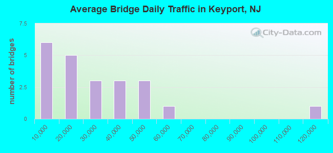
- 599,488Total average daily traffic
- 11,134Total average daily truck traffic
- National Bridge Inventory (NBI) Registered Bridges for Keyport
- No street view available for this location
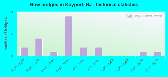
- New bridges - historical statistics
- 21920-1929
- 41930-1939
- 11940-1949
- 91950-1959
- 21960-1969
- 21970-1979
- 12000-2009
- 12010-2019
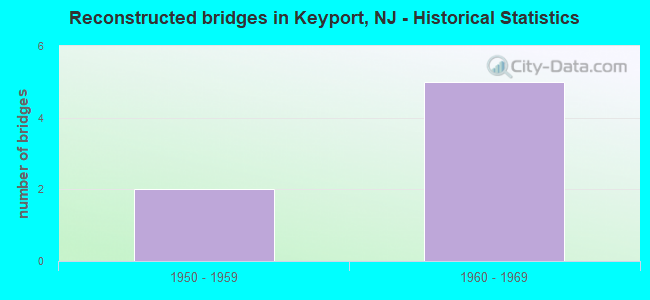
- Reconstructed bridges - Historical Statistics
- 21950-1959
- 51960-1969
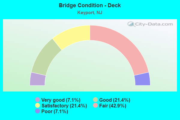
- Bridge Condition - Deck
- 7.1%Very good
- 21.4%Good
- 21.4%Satisfactory
- 42.9%Fair
- 7.1%Poor
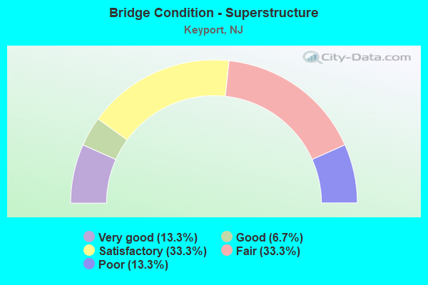
- Bridge Condition - Superstructure
- 13.3%Very good
- 6.7%Good
- 33.3%Satisfactory
- 33.3%Fair
- 13.3%Poor
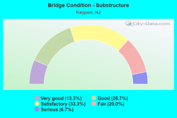
- Bridge Condition - Substructure
- 13.3%Very good
- 26.7%Good
- 33.3%Satisfactory
- 20.0%Fair
- 6.7%Serious
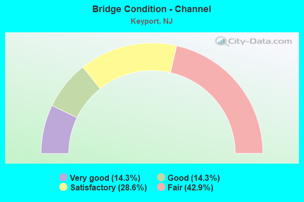
- Bridge Condition - Channel
- 14.3%Very good
- 14.3%Good
- 28.6%Satisfactory
- 42.9%Fair
Find on map >> Show street view
Structure Number: 13000R3, Location: KEYPORT BOROUGH (Lat: 40.440481, Lng: -74.188039), Route carried "on" structure: County highway 6, Year Built: 1930, Status: Closed, Structure Length: 1.07m (3.51ft), Average Daily Traffic: 2,886 (year 2019), Truck Traffic: 3%, Average Future Daily Traffic: 3,521 (year 2039), Features Intersected: CHINGARORA CREEK
Minimum Vertical Clearance: 30+ m (98+ ft), Kilometerpoint: 1.239, Lanes on structure: 2, Owner: County Highway Agency, Approaching Roadway Width: 9.1m (29.9ft), Skew: 2 degrees, Material/Design: Steel, Design/Construction: Stringer/Multi-beam, Number Of Spans In Main Unit: 1, Length of Maximum Span: 9.8m (32.2ft), Curb or Sidewalk Widths: Left: 1.8m (5.9ft), Right: 0.1m (0.3ft), Curb-To-Curb Width: 9.3m (30.5ft), Out-to-Out Width: 11.7m (38.4ft)
Condition: Deck: Fair, Superstructure: Fair, Substructure: Fair, Channel: Fair, Operating Rating: 50.8 metric tons, Method Used To Determine Operating Rating: Load Factor (LF), Inventory Rating: 29.9 metric tons, Method Used To Determine Inventory Rating: Load Factor (LF), Structural Evaluation: Somewhat better than minimum adequacy, Deck Geometry: Meets minimum limits, Waterway Adequacy: Somewhat better than minimum adequacy, Approach Roadway Alignment: Better than present minimum criteria, Length Of Structure Improvement: 1.10m (3.61ft), Designated Inspection Frequency: Every 24 months, Inspection Date: May 2021, Bridge Improvement Cost: $598,000, Roadway Improvement Cost: $322,000, Total Project Cost: $1,280,000 ( Estimate for 2015), Deck Structure Type: Concrete Cast-file-Place, Wearing Surface/Protective System: Wearing Surface: Bituminous
Find on map >> Show street view
Structure Number: 13000R4, Location: 1/2 MI. NW of NJ 36 (Lat: 40.439319, Lng: -74.188319), Route carried "on" structure: County highway 6, Year Built: 2007, Status: Open, Structure Length: 1.49m (4.89ft), Average Daily Traffic: 3,091 (year 2021), Truck Traffic: 3%, Average Future Daily Traffic: 3,772 (year 2041), Design Load: HS 25 or greater, Features Intersected: CHINGARORA CREEK
Minimum Vertical Clearance: 30+ m (98+ ft), Kilometerpoint: 0.145, Lanes on structure: 2, Owner: County Highway Agency, Approaching Roadway Width: 9.4m (30.8ft), Material/Design: Prestressed concrete, Design/Construction: Slab, Number Of Spans In Main Unit: 1, Length of Maximum Span: 13.4m (44.0ft), Curb or Sidewalk Widths: Left: 1.5m (4.9ft), Right: 0.3m (1.0ft), Curb-To-Curb Width: 11.0m (36.1ft), Out-to-Out Width: 13.6m (44.6ft)
Condition: Deck: Good, Superstructure: Very good, Substructure: Good, Channel: Good, Inventory Rating: 48.1 metric tons, Method Used To Determine Inventory Rating: Load Factor (LF), Structural Evaluation: Better than present minimum criteria, Deck Geometry: Somewhat better than minimum adequacy, Waterway Adequacy: Better than present minimum criteria, Approach Roadway Alignment: Equal to present minimum criteria, Designated Inspection Frequency: Every 24 months, Inspection Date: May 2021, Deck Structure Type: Concrete Cast-file-Place, Wearing Surface/Protective System: Wearing Surface: Monolithic Concrete, Deck Protection: Galvanized Reinforcing
Find on map >> Show street view
Structure Number: 130MA11, Location: 1.6 mi SE GSP exit 120 (Lat: 40.423050, Lng: -74.228500), Route carried "on" structure: City street , Year Built: 1944, Year Reconstructed: 1961, Status: Open, Structure Length: 1.40m (4.59ft), Average Daily Traffic: 9,570 (year 2021), Truck Traffic: 1%, Average Future Daily Traffic: 11,485 (year 2041), Features Intersected: MATAWAN CREEK, Facility Carried by Structure: ABERDEEN ROAD
Minimum Vertical Clearance: 30+ m (98+ ft), Kilometerpoint: 0.000, Lanes on structure: 2, Owner: County Highway Agency, Approaching Roadway Width: 8.2m (26.9ft), Material/Design: Concrete, Design/Construction: Box Beam or Girders - Multiple, Number Of Spans In Main Unit: 3, Length of Maximum Span: 4.6m (15.1ft), Curb or Sidewalk Widths: Left: 1.4m (4.6ft), Right: 0.0m, Curb-To-Curb Width: 7.5m (24.6ft), Out-to-Out Width: 7.9m (25.9ft)
Condition: Deck: Poor, Superstructure: Poor, Substructure: Serious, Channel: Fair, Operating Rating: 39.0 metric tons, Method Used To Determine Operating Rating: Load Factor (LF), Inventory Rating: 23.6 metric tons, Method Used To Determine Inventory Rating: Load Factor (LF), Structural Evaluation: High priority of corrective action, Deck Geometry: High priority of replacement, Waterway Adequacy: Equal to present minimum criteria, Approach Roadway Alignment: Equal to present minimum criteria, Length Of Structure Improvement: 2.10m (6.89ft), Designated Inspection Frequency: Every 24 months, Underwater Inspection Frequency: Every 48 months, Other Special Inspection Frequency: Every 12 months, Inspection Date: March 2021, Underwater Inspection Date: April 2019, Other Special Inspection Date: March 2021, Bridge Improvement Cost: $1,347,000, Roadway Improvement Cost: $202,000, Total Project Cost: $2,310,000 ( Estimate for 2021), Deck Structure Type: Concrete Precast Panels, Wearing Surface/Protective System: Wearing Surface: Bituminous
Find on map >> Show street view
Structure Number: 130MA14, Location: NEAR KEYPORT HARBOR (Lat: 40.435500, Lng: -74.214089), Route carried "on" structure: County highway 6, Year Built: 2018, Status: Open, Structure Length: 10.73m (35.20ft), Average Daily Traffic: 6,682 (year 2021), Truck Traffic: 3%, Average Future Daily Traffic: 8,153 (year 2041), Design Load: HL 93, Features Intersected: MATAWAN CREEK
Minimum Vertical Clearance: 30+ m (98+ ft), Kilometerpoint: 0.837, Lanes on structure: 2, Owner: County Highway Agency, Approaching Roadway Width: 9.8m (32.2ft), Navigation Control: Yes ( Vertical Clearance: 3.7m (12.1ft), Horizontal Clearance: 14.6m (47.9ft)), Material/Design: Steel, Design/Construction: Stringer/Multi-beam, Number Of Spans In Main Unit: 4, Number Of Approach Spans: 2, Length of Maximum Span: 30.5m (100.1ft), Curb or Sidewalk Widths: Left: 1.8m (5.9ft), Right: 1.8m (5.9ft), Curb-To-Curb Width: 9.8m (32.2ft), Out-to-Out Width: 14.4m (47.2ft)
Condition: Deck: Very good, Superstructure: Very good, Substructure: Very good, Channel: Very good, Operating Rating: 88.9 metric tons, Method Used To Determine Operating Rating: Field evaluation and documented engineering judgment, Inventory Rating: 53.5 metric tons, Method Used To Determine Inventory Rating: Field evaluation and documented engineering judgment, Structural Evaluation: Equal to present desirable criteria, Deck Geometry: Meets minimum limits, Waterway Adequacy: Equal to present desirable criteria, Approach Roadway Alignment: Equal to present minimum criteria, Length Of Structure Improvement: 9.91m (32.51ft), Designated Inspection Frequency: Every 24 months, Underwater Inspection Frequency: Every 48 months, Inspection Date: May 2021, Underwater Inspection Date: June 2019, Bridge Improvement Cost: $5,872,000, Roadway Improvement Cost: $166,000, Total Project Cost: $8,400,000 ( Estimate for 2015), Deck Structure Type: Concrete Cast-file-Place, Wearing Surface/Protective System: Deck Protection: Galvanized Reinforcing
Find on map >> Show street view
Structure Number: 1313151, Location: 3.5 MI S OF NJ 36 JCT (Lat: 40.411361, Lng: -74.139000), Route carried "on" structure: State highway 35, Year Built: 1928, Year Reconstructed: 1968, Status: Open, Structure Length: 0.73m (2.40ft), Average Daily Traffic: 42,902 (year 2020), Truck Traffic: 4%, Average Future Daily Traffic: 52,349 (year 2040), Design Load: H 20, Features Intersected: MAHORAS BROOK
Minimum Vertical Clearance: 30+ m (98+ ft), Kilometerpoint: 63.891, Lanes on structure: 5, Base Highway Network: Yes, Owner: State Highway Agency, Approaching Roadway Width: 21.9m (71.9ft), Skew: 30 degrees, Material/Design: Concrete, Design/Construction: Arch - Deck, Number Of Spans In Main Unit: 1, Length of Maximum Span: 7.3m (24.0ft), Curb or Sidewalk Widths: Left: 1.7m (5.6ft), Right: 1.8m (5.9ft), Curb-To-Curb Width: 21.9m (71.9ft), Out-to-Out Width: 26.8m (87.9ft)
Condition: Superstructure: Satisfactory, Substructure: Very good, Channel: Fair, Inventory Rating: 73.5 metric tons, Method Used To Determine Inventory Rating: Load Factor (LF), Structural Evaluation: Equal to present minimum criteria, Deck Geometry: Somewhat better than minimum adequacy, Waterway Adequacy: High priority of corrective action, Approach Roadway Alignment: Equal to present desirable criteria, Length Of Structure Improvement: 0.73m (2.40ft), Designated Inspection Frequency: Every 24 months, Inspection Date: July 2020, Bridge Improvement Cost: $310,000, Total Project Cost: $310,000 ( Estimate for 2020)
Find on map >> Show street view
Structure Number: 1313153, Location: AT 35-36-GSP JCT (Lat: 40.425400, Lng: -74.200331), Route carried "on" structure: State highway 35, Year Built: 1931, Year Reconstructed: 1955, Status: Open, Structure Length: 3.54m (11.61ft), Average Daily Traffic: 18,017 (year 2021), Truck Traffic: 4%, Average Future Daily Traffic: 22,093 (year 2041), Features Intersected: NJ RT 36NB,RAMP G(GSP)
Minimum Vertical Clearance: 30+ m (98+ ft), Kilometerpoint: 69.459, Lanes on structure: 2, Lanes under structure: 3, Base Highway Network: Yes, Owner: State Highway Agency, Approaching Roadway Width: 9.1m (29.9ft), Skew: 2 degrees, Material/Design: Steel, Design/Construction: Stringer/Multi-beam, Number Of Spans In Main Unit: 2, Length of Maximum Span: 17.4m (57.1ft), Curb or Sidewalk Widths: Left: 1.8m (5.9ft), Right: 1.8m (5.9ft), Curb-To-Curb Width: 9.1m (29.9ft), Out-to-Out Width: 13.5m (44.3ft)
Condition: Deck: Fair, Superstructure: Poor, Substructure: Fair, Operating Rating: 62.6 metric tons, Method Used To Determine Operating Rating: Load Factor (LF), Inventory Rating: 37.2 metric tons, Method Used To Determine Inventory Rating: Load Factor (LF), Structural Evaluation: Meets minimum limits, Deck Geometry: Meets minimum limits, Underclear: Meets minimum limits, Approach Roadway Alignment: Equal to present minimum criteria, Length Of Structure Improvement: 3.54m (11.61ft), Designated Inspection Frequency: Every 24 months, Inspection Date: June 2021, Bridge Improvement Cost: $2,048,000, Roadway Improvement Cost: $205,000, Total Project Cost: $3,072,000 ( Estimate for 2019), Deck Structure Type: Concrete Cast-file-Place, Wearing Surface/Protective System: Wearing Surface: Bituminous
Find on map >> Show street view
Structure Number: 1313155, Location: 0.4 MI N OF 35-36 JCT (Lat: 40.427400, Lng: -74.207111), Route carried "on" structure: State highway 35, Year Built: 1927, Year Reconstructed: 1965, Status: Open, Structure Length: 1.34m (4.40ft), Average Daily Traffic: 35,055 (year 2021), Truck Traffic: 4%, Average Future Daily Traffic: 42,067 (year 2041), Features Intersected: LUPPATATONG CREEK
Minimum Vertical Clearance: 30+ m (98+ ft), Kilometerpoint: 70.087, Lanes on structure: 5, Base Highway Network: Yes, Owner: State Highway Agency, Approaching Roadway Width: 23.8m (78.1ft), Skew: 30 degrees, Material/Design: Steel, Design/Construction: Stringer/Multi-beam, Number Of Spans In Main Unit: 1, Length of Maximum Span: 12.8m (42.0ft), Curb or Sidewalk Widths: Left: 2.1m (6.9ft), Right: 0.3m (1.0ft), Curb-To-Curb Width: 23.8m (78.1ft), Out-to-Out Width: 29.3m (96.1ft)
Condition: Deck: Fair, Superstructure: Fair, Substructure: Fair, Channel: Satisfactory, Operating Rating: 49.0 metric tons, Method Used To Determine Operating Rating: Load Factor (LF), Inventory Rating: 29.0 metric tons, Method Used To Determine Inventory Rating: Load Factor (LF), Structural Evaluation: Somewhat better than minimum adequacy, Deck Geometry: Better than present minimum criteria, Waterway Adequacy: Equal to present minimum criteria, Approach Roadway Alignment: Equal to present desirable criteria, Designated Inspection Frequency: Every 24 months, Inspection Date: May 2021, Deck Structure Type: Concrete Cast-file-Place, Wearing Surface/Protective System: Wearing Surface: Bituminous
Find on map >> Show street view
Structure Number: 1313157, Location: 0.4MI SE OF MATAWAN CREEK (Lat: 40.428419, Lng: -74.211969), Route carried "on" structure: City street , Year Built: 1965, Status: Open, Structure Length: 4.42m (14.50ft), Average Daily Traffic: 11,358 (year 2021), Truck Traffic: 3%, Average Future Daily Traffic: 13,859 (year 2041), Design Load: HS 20+Mod, Features Intersected: ROUTE 35, Facility Carried by Structure: BROADWAY AVE
Minimum Vertical Clearance: 30+ m (98+ ft), Kilometerpoint: 21.259, Lanes on structure: 4, Lanes under structure: 5, Owner: State Highway Agency, Approaching Roadway Width: 15.2m (49.9ft), Material/Design: Steel, Design/Construction: Stringer/Multi-beam, Number Of Spans In Main Unit: 3, Length of Maximum Span: 29.9m (98.1ft), Curb or Sidewalk Widths: Left: 1.8m (5.9ft), Right: 1.8m (5.9ft), Curb-To-Curb Width: 15.3m (50.2ft), Out-to-Out Width: 19.5m (64.0ft)
Condition: Deck: Fair, Superstructure: Satisfactory, Substructure: Satisfactory, Operating Rating: 65.3 metric tons, Method Used To Determine Operating Rating: Load Factor (LF), Inventory Rating: 39.0 metric tons, Method Used To Determine Inventory Rating: Load Factor (LF), Structural Evaluation: Equal to present minimum criteria, Deck Geometry: High priority of corrective action, Underclear: Equal to present minimum criteria, Approach Roadway Alignment: Equal to present minimum criteria, Length Of Structure Improvement: 4.42m (14.50ft), Designated Inspection Frequency: Every 24 months, Inspection Date: August 2021, Bridge Improvement Cost: $1,619,000, Roadway Improvement Cost: $120,000, Total Project Cost: $1,912,000 ( Estimate for 2021), Deck Structure Type: Concrete Cast-file-Place, Wearing Surface/Protective System: Wearing Surface: Monolithic Concrete
Find on map >> Show street view
Structure Number: 361182O, Location: 0.25 MI SE OF GSP&RT36 JC (Lat: 40.416789, Lng: -74.202250), Route carried "on" structure: Other road GSP, Year Built: 1954, Year Reconstructed: 1971, Status: Open, Structure Length: 6.68m (21.92ft), Average Daily Traffic: 45,689 (year 2020), Truck Traffic: 1%, Average Future Daily Traffic: 55,750 (year 2040), Design Load: H 20, Features Intersected: NJ TRANSIT RR, Facility Carried by Structure: PARKWAY NBO
Minimum Vertical Clearance: 30+ m (98+ ft), Kilometerpoint: 190.385, Lanes on structure: 3, Base Highway Network: Yes, Toll: On toll road, Owner: State Toll Authority, Approaching Roadway Width: 14.0m (45.9ft), Skew: 5 degrees, Material/Design: Steel, Design/Construction: Stringer/Multi-beam, Number Of Spans In Main Unit: 3, Length of Maximum Span: 22.3m (73.2ft), Curb-To-Curb Width: 14.0m (45.9ft), Out-to-Out Width: 15.2m (49.9ft)
Condition: Deck: Satisfactory, Superstructure: Good, Substructure: Satisfactory, Operating Rating: 61.9 metric tons, Method Used To Determine Operating Rating: Load and Resistance Factor Rating (LRFR) rating reported by rating factor(RF) method using HL-93 loadings, Inventory Rating: 47.6 metric tons, Method Used To Determine Inventory Rating: Load and Resistance Factor Rating (LRFR) rating reported by rating factor(RF) method using HL-93 loadings, Structural Evaluation: Equal to present minimum criteria, Deck Geometry: Meets minimum limits, Underclear: Somewhat better than minimum adequacy, Approach Roadway Alignment: Equal to present desirable criteria, Designated Inspection Frequency: Every 24 months, Inspection Date: July 2020, Deck Structure Type: Concrete Cast-file-Place, Wearing Surface/Protective System: Wearing Surface: Bituminous, Membrane: Preformed Fabric
Find on map >> Show street view
Structure Number: 361183I, Location: 0.25 MI SE OF GSP&RT36 JC (Lat: 40.417269, Lng: -74.204303), Route carried "on" structure: Other road GSP, Year Built: 1975, Status: Open, Structure Length: 7.62m (25.00ft), Average Daily Traffic: 39,217 (year 2020), Truck Traffic: 1%, Average Future Daily Traffic: 47,852 (year 2040), Design Load: H 20, Features Intersected: NJ TRANSIT RR, Facility Carried by Structure: Parkway NBI
Minimum Vertical Clearance: 30+ m (98+ ft), Kilometerpoint: 190.224, Lanes on structure: 2, Base Highway Network: Yes, Toll: On toll road, Owner: State Toll Authority, Approaching Roadway Width: 12.5m (41.0ft), Skew: 5 degrees, Material/Design: Prestressed concrete, Design/Construction: Stringer/Multi-beam, Number Of Spans In Main Unit: 3, Length of Maximum Span: 25.9m (85.0ft), Curb-To-Curb Width: 12.5m (41.0ft), Out-to-Out Width: 13.4m (44.0ft)
Condition: Deck: Good, Superstructure: Satisfactory, Substructure: Satisfactory, Operating Rating: 44.4 metric tons, Method Used To Determine Operating Rating: Load and Resistance Factor Rating (LRFR) rating reported by rating factor(RF) method using HL-93 loadings, Inventory Rating: 18.8 metric tons, Method Used To Determine Inventory Rating: Load and Resistance Factor Rating (LRFR) rating reported by rating factor(RF) method using HL-93 loadings, Structural Evaluation: Meets minimum limits, Deck Geometry: Better than present minimum criteria, Underclear: Somewhat better than minimum adequacy, Approach Roadway Alignment: Equal to present desirable criteria, Designated Inspection Frequency: Every 24 months, Inspection Date: July 2020, Deck Structure Type: Concrete Cast-file-Place, Wearing Surface/Protective System: Wearing Surface: Bituminous
Find on map >> Show street view
Structure Number: 361184A, Location: 0.25 MI SE OF GSP&RT36 JC (Lat: 40.417869, Lng: -74.208961), Route carried "on" structure: Ramp Other road GSP, Year Built: 1971, Status: Open, Structure Length: 10.73m (35.20ft), Average Daily Traffic: 6,055 (year 2020), Truck Traffic: 1%, Average Future Daily Traffic: 7,389 (year 2040), Design Load: H 20, Features Intersected: NJ TRANSIT RR, Facility Carried by Structure: Parkway Ramp 118SB
Minimum Vertical Clearance: 30+ m (98+ ft), Kilometerpoint: 190.224, Lanes on structure: 1, Toll: On toll road, Owner: State Toll Authority, Approaching Roadway Width: 6.1m (20.0ft), Skew: 6 degrees, Material/Design: Steel, Design/Construction: Stringer/Multi-beam, Number Of Spans In Main Unit: 3, Length of Maximum Span: 40.8m (133.9ft), Curb-To-Curb Width: 6.1m (20.0ft), Out-to-Out Width: 7.0m (23.0ft)
Condition: Deck: Good, Superstructure: Fair, Substructure: Satisfactory, Operating Rating: 48.9 metric tons, Method Used To Determine Operating Rating: Load and Resistance Factor Rating (LRFR) rating reported by rating factor(RF) method using HL-93 loadings, Inventory Rating: 37.6 metric tons, Method Used To Determine Inventory Rating: Load and Resistance Factor Rating (LRFR) rating reported by rating factor(RF) method using HL-93 loadings, Structural Evaluation: Somewhat better than minimum adequacy, Deck Geometry: Somewhat better than minimum adequacy, Underclear: Somewhat better than minimum adequacy, Approach Roadway Alignment: Equal to present desirable criteria, Designated Inspection Frequency: Every 24 months, Inspection Date: July 2020, Deck Structure Type: Concrete Cast-file-Place, Wearing Surface/Protective System: Wearing Surface: Bituminous, Membrane: Preformed Fabric
Find on map >> Show street view
Structure Number: 361184U, Location: 0.25 MI SE OF GSP&RT36 JC (Lat: 40.417797, Lng: -74.208428), Route carried "on" structure: Other road GSP, Year Built: 1953, Year Reconstructed: 1971, Status: Open, Structure Length: 9.14m (29.99ft), Average Daily Traffic: 48,944 (year 2020), Truck Traffic: 1%, Average Future Daily Traffic: 59,721 (year 2040), Design Load: H 20, Features Intersected: NJ TRANSIT RR
Minimum Vertical Clearance: 30+ m (98+ ft), Kilometerpoint: 190.546, Lanes on structure: 3, Base Highway Network: Yes, Toll: On toll road, Owner: State Toll Authority, Approaching Roadway Width: 14.3m (46.9ft), Skew: 6 degrees, Material/Design: Steel, Design/Construction: Stringer/Multi-beam, Number Of Spans In Main Unit: 3, Length of Maximum Span: 28.3m (92.8ft), Curb-To-Curb Width: 14.0m (45.9ft), Out-to-Out Width: 15.2m (49.9ft)
Condition: Deck: Satisfactory, Superstructure: Satisfactory, Substructure: Satisfactory, Operating Rating: 42.4 metric tons, Method Used To Determine Operating Rating: Load and Resistance Factor Rating (LRFR) rating reported by rating factor(RF) method using HL-93 loadings, Inventory Rating: 32.7 metric tons, Method Used To Determine Inventory Rating: Load and Resistance Factor Rating (LRFR) rating reported by rating factor(RF) method using HL-93 loadings, Structural Evaluation: Equal to present minimum criteria, Deck Geometry: Meets minimum limits, Underclear: Somewhat better than minimum adequacy, Approach Roadway Alignment: Equal to present desirable criteria, Designated Inspection Frequency: Every 24 months, Inspection Date: July 2020, Deck Structure Type: Concrete Cast-file-Place, Wearing Surface/Protective System: Wearing Surface: Bituminous, Membrane: Preformed Fabric
Find on map >> Show street view
Structure Number: 361185A, Location: AT GSP&RT 35 JUNCTION (Lat: 40.425231, Lng: -74.204764), Route carried "on" structure: Ramp Other road GSP, Year Built: 1954, Status: Open, Structure Length: 4.27m (14.01ft), Average Daily Traffic: 17,543 (year 2018), Truck Traffic: 1%, Average Future Daily Traffic: 21,400 (year 2038), Design Load: H 20, Features Intersected: NJ ROUTE 35 SB, Facility Carried by Structure: INT.117 RAMP A
Minimum Vertical Clearance: 30+ m (98+ ft), Kilometerpoint: 190.707, Lanes on structure: 2, Lanes under structure: 2, Toll: On toll road, Owner: State Toll Authority, Approaching Roadway Width: 7.3m (24.0ft), Skew: 32 degrees, Material/Design: Steel, Design/Construction: Stringer/Multi-beam, Number Of Spans In Main Unit: 3, Length of Maximum Span: 16.8m (55.1ft), Curb-To-Curb Width: 14.5m (47.6ft), Out-to-Out Width: 16.0m (52.5ft)
Condition: Deck: Fair, Superstructure: Fair, Substructure: Good, Operating Rating: 50.2 metric tons, Method Used To Determine Operating Rating: Load and Resistance Factor Rating (LRFR) rating reported by rating factor(RF) method using HL-93 loadings, Inventory Rating: 38.6 metric tons, Method Used To Determine Inventory Rating: Load and Resistance Factor Rating (LRFR) rating reported by rating factor(RF) method using HL-93 loadings, Structural Evaluation: Somewhat better than minimum adequacy, Deck Geometry: Superior to present desirable criteria, Underclear: Equal to present minimum criteria, Approach Roadway Alignment: Equal to present minimum criteria, Designated Inspection Frequency: Every 24 months, Inspection Date: July 2020, Deck Structure Type: Concrete Cast-file-Place, Wearing Surface/Protective System: Wearing Surface: Bituminous
Find on map >> Show street view
Structure Number: 361185C, Location: GSP Interchange 117 (Lat: 40.420011, Lng: -74.207811), Route carried "on" structure: Other road GSP, Year Built: 1953, Status: Open, Structure Length: 0.82m (2.69ft), Average Daily Traffic: 56,157 (year 2018), Truck Traffic: 1%, Average Future Daily Traffic: 68,522 (year 2038), Design Load: HS 20, Features Intersected: Luppatcong Creek, Facility Carried by Structure: NBO & Int. 117 Rps
Minimum Vertical Clearance: 30+ m (98+ ft), Kilometerpoint: 190.820, Lanes on structure: 4, Base Highway Network: Yes, Toll: On toll road, Owner: State Toll Authority, Approaching Roadway Width: 19.8m (65.0ft), Skew: 9 degrees, Material/Design: Concrete, Design/Construction: Culvert, Number Of Spans In Main Unit: 2, Length of Maximum Span: 3.7m (12.1ft)
Condition: Channel: Satisfactory, Culverts: Good, Operating Rating: 93.6 metric tons, Method Used To Determine Operating Rating: Load and Resistance Factor Rating (LRFR) rating reported by rating factor(RF) method using HL-93 loadings, Inventory Rating: 72.3 metric tons, Method Used To Determine Inventory Rating: Load and Resistance Factor Rating (LRFR) rating reported by rating factor(RF) method using HL-93 loadings, Structural Evaluation: Better than present minimum criteria, Waterway Adequacy: Superior to present desirable criteria, Approach Roadway Alignment: Equal to present desirable criteria, Designated Inspection Frequency: Every 24 months, Inspection Date: July 2020
Find on map >> Show street view
Structure Number: 361185O, Location: AT GSP & RT 36 JUNCTION (Lat: 40.419681, Lng: -74.206911), Route carried "on" structure: Other road GSP, Year Built: 1954, Status: Open, Structure Length: 4.21m (13.81ft), Average Daily Traffic: 21,759 (year 2020), Truck Traffic: 1%, Average Future Daily Traffic: 26,550 (year 2040), Design Load: H 20, Features Intersected: INT. 117 RAMPS A & E
Minimum Vertical Clearance: 30+ m (98+ ft), Kilometerpoint: 190.707, Lanes on structure: 3, Lanes under structure: 3, Base Highway Network: Yes, Toll: On toll road, Owner: State Toll Authority, Approaching Roadway Width: 14.3m (46.9ft), Skew: 1 degrees, Material/Design: Steel, Design/Construction: Stringer/Multi-beam, Number Of Spans In Main Unit: 3, Length of Maximum Span: 20.7m (67.9ft), Curb-To-Curb Width: 14.3m (46.9ft), Out-to-Out Width: 15.2m (49.9ft)
Condition: Deck: Fair, Superstructure: Fair, Substructure: Good, Operating Rating: 52.5 metric tons, Method Used To Determine Operating Rating: Load and Resistance Factor Rating (LRFR) rating reported by rating factor(RF) method using HL-93 loadings, Inventory Rating: 40.5 metric tons, Method Used To Determine Inventory Rating: Load and Resistance Factor Rating (LRFR) rating reported by rating factor(RF) method using HL-93 loadings, Structural Evaluation: Somewhat better than minimum adequacy, Deck Geometry: Meets minimum limits, Underclear: High priority of corrective action, Approach Roadway Alignment: Superior to present desirable criteria, Length Of Structure Improvement: 4.21m (13.81ft), Designated Inspection Frequency: Every 24 months, Inspection Date: August 2020, Bridge Improvement Cost: $1,987,000, Roadway Improvement Cost: $298,000, Total Project Cost: $2,635,000 ( Estimate for 2018), Deck Structure Type: Concrete Cast-file-Place, Wearing Surface/Protective System: Wearing Surface: Bituminous
Find on map >> Show street view
Structure Number: 361188T, Location: 0.25 MI NW OF GSP&RT36 JC (Lat: 40.420989, Lng: -74.212219), Route carried "on" structure: County highway 3, Year Built: 1954, Year Reconstructed: 1971, Status: Open, Structure Length: 10.21m (33.50ft), Average Daily Traffic: 12,475 (year 2020), Truck Traffic: 4%, Average Future Daily Traffic: 15,217 (year 2040), Design Load: H 20, Features Intersected: GSP NBO, NBI & SB
Minimum Vertical Clearance: 30+ m (98+ ft), Kilometerpoint: 20.326, Lanes on structure: 2, Lanes under structure: 9, Owner: State Toll Authority, Approaching Roadway Width: 11.0m (36.1ft), Skew: 2 degrees, Material/Design: Steel, Design/Construction: Stringer/Multi-beam, Number Of Spans In Main Unit: 5, Length of Maximum Span: 31.4m (103.0ft), Curb or Sidewalk Widths: Left: 0.8m (2.6ft), Right: 0.8m (2.6ft), Curb-To-Curb Width: 11.0m (36.1ft), Out-to-Out Width: 13.5m (44.3ft)
Condition: Deck: Satisfactory, Superstructure: Satisfactory, Substructure: Good, Operating Rating: 64.8 metric tons, Method Used To Determine Operating Rating: Load and Resistance Factor Rating (LRFR) rating reported by rating factor(RF) method using HL-93 loadings, Inventory Rating: 49.9 metric tons, Method Used To Determine Inventory Rating: Load and Resistance Factor Rating (LRFR) rating reported by rating factor(RF) method using HL-93 loadings, Structural Evaluation: Equal to present minimum criteria, Deck Geometry: Meets minimum limits, Underclear: High priority of corrective action, Approach Roadway Alignment: Equal to present desirable criteria, Length Of Structure Improvement: 10.21m (33.50ft), Designated Inspection Frequency: Every 24 months, Inspection Date: September 2020, Bridge Improvement Cost: $200,000, Roadway Improvement Cost: $200,000, Total Project Cost: $400,000 ( Estimate for 2018), Deck Structure Type: Concrete Cast-file-Place, Wearing Surface/Protective System: Wearing Surface: Bituminous, Membrane: Preformed Fabric
Find on map >> Show street view
Structure Number: 1313153, Location: AT 35-36-GSP JCT (Lat: 40.425400, Lng: -74.200331), Route carried "under" structure: State highway 36, Year Built: 1931, Structure Length: 0. m, Average Daily Traffic: 18,747 (year 2021), Truck Traffic: 4%, Features Intersected: NJ RT 36NB,RAMP G(GSP), Facility Carried by Structure: NJ 35 NB
Minimum Vertical Clearance: 4.72m (15.49ft), Kilometerpoint: 39.268, Lanes on structure: 2, Lanes under structure: 2, Material/Design: Steel, Design/Construction: Stringer/Multi-beam, Length of Maximum Span: 17.4m (57.1ft)
Find on map >> Show street view
Structure Number: 1313153, Location: AT 35-36-GSP JCT (Lat: 40.425400, Lng: -74.200331), Route carried "under" structure: Ramp Other road GSP, Year Built: 1931, Structure Length: 0. m, Average Daily Traffic: 7,881 (year 2019), Truck Traffic: 4%, Features Intersected: NJ RT 36NB,RAMP G(GSP), Facility Carried by Structure: NJ 35 NB
Minimum Vertical Clearance: 4.70m (15.42ft), Kilometerpoint: 190.707, Lanes on structure: 2, Lanes under structure: 1, Toll: On toll road, Material/Design: Steel, Design/Construction: Stringer/Multi-beam, Length of Maximum Span: 17.4m (57.1ft)
Find on map >> Show street view
Structure Number: 1313157, Location: 0.4MI SE OF MATAWAN CREEK (Lat: 40.428419, Lng: -74.211969), Route carried "under" structure: State highway 35, Year Built: 1965, Structure Length: 0. m, Average Daily Traffic: 36,925 (year 2021), Truck Traffic: 4%, Features Intersected: ROUTE 35, Facility Carried by Structure: BROADWAY AVE
Minimum Vertical Clearance: 5.33m (17.49ft), Kilometerpoint: 70.409, Lanes on structure: 4, Lanes under structure: 5, Material/Design: Steel, Design/Construction: Stringer/Multi-beam, Length of Maximum Span: 29.9m (98.1ft)
Find on map >> Show street view
Structure Number: 361185A, Location: AT GSP&RT 35 JUNCTION (Lat: 40.425231, Lng: -74.204764), Route carried "under" structure: State highway 35, Year Built: 1954, Structure Length: 0. m, Average Daily Traffic: 21,867 (year 2018), Truck Traffic: 4%, Features Intersected: NJ ROUTE 35 SB, Facility Carried by Structure: INT.117 RAMP A
Minimum Vertical Clearance: 4.50m (14.76ft), Kilometerpoint: 0.000, Lanes on structure: 2, Lanes under structure: 2, Material/Design: Steel, Design/Construction: Stringer/Multi-beam, Length of Maximum Span: 16.8m (55.1ft)
Find on map >> Show street view
Structure Number: 361185O, Location: AT GSP & RT 36 JUNCTION (Lat: 40.419681, Lng: -74.206911), Route carried "under" structure: Ramp Other road GSP, Year Built: 1954, Structure Length: 0. m, Average Daily Traffic: 21,918 (year 2018), Truck Traffic: 1%, Features Intersected: INT. 117 RAMPS A & E
Minimum Vertical Clearance: 4.77m (15.65ft), Kilometerpoint: 190.707, Lanes on structure: 3, Lanes under structure: 3, Toll: On toll road, Material/Design: Steel, Design/Construction: Stringer/Multi-beam, Length of Maximum Span: 20.7m (67.9ft)
Find on map >> Show street view
Structure Number: 361188T, Location: 0.25 MI NW OF GSP&RT36 JC (Lat: 40.420989, Lng: -74.212219), Route carried "under" structure: Other road GSP, Year Built: 1954, Structure Length: 0. m, Average Daily Traffic: 114,750 (year 2020), Features Intersected: GSP NBO, NBI & SB, Facility Carried by Structure: LLOYD ROAD (CR 3)
Minimum Vertical Clearance: 4.70m (15.42ft), Kilometerpoint: 191.174, Lanes on structure: 2, Lanes under structure: 9, Toll: On toll road, Material/Design: Steel, Design/Construction: Stringer/Multi-beam, Length of Maximum Span: 31.4m (103.0ft)