Bridge Statistics for Keystone, Florida (FL)
Condition, Traffic, Stress, Structural Evaluation, Project Costs
- National Bridge Inventory (NBI) Statistics
- 18Number of bridges
- 112ft / 33.6mTotal length
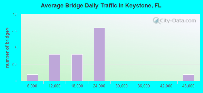
- 312,399Total average daily traffic
- 29,435Total average daily truck traffic
- National Bridge Inventory (NBI) Registered Bridges for Keystone
- No street view available for this location
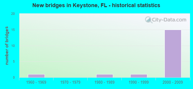
- New bridges - historical statistics
- 11960-1969
- 11980-1989
- 11990-1999
- 152000-2009
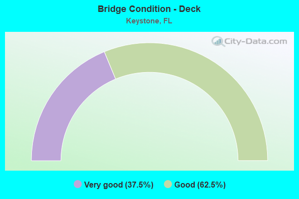
- Bridge Condition - Deck
- 37.5%Very good
- 62.5%Good
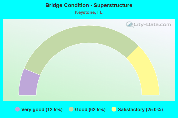
- Bridge Condition - Superstructure
- 12.5%Very good
- 62.5%Good
- 25.0%Satisfactory
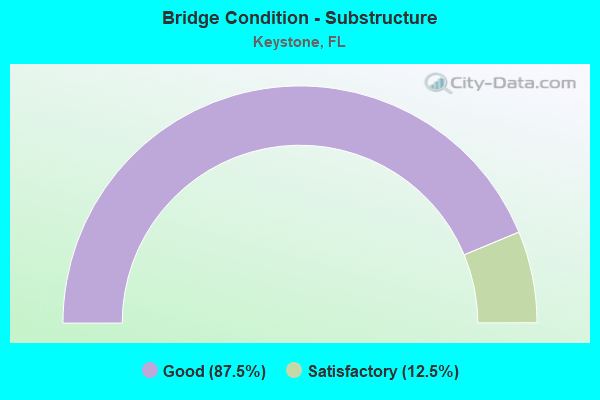
- Bridge Condition - Substructure
- 87.5%Good
- 12.5%Satisfactory
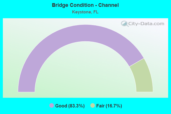
- Bridge Condition - Channel
- 83.3%Good
- 16.7%Fair
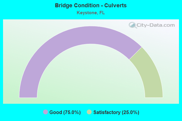
- Bridge Condition - Culverts
- 75.0%Good
- 25.0%Satisfactory
Find on map >> Show street view
Structure Number: 100625, Location: 0.3MI N OF VETERANS EXPWY (Lat: 28.125853, Lng: -82.547475), Route carried "on" structure: State highway 589, Year Built: 2000, Status: Open, Structure Length: 1.71m (5.61ft), Average Daily Traffic: 44,900 (year 2020), Truck Traffic: 10%, Average Future Daily Traffic: 77,902 (year 2042), Design Load: HS 20+Mod, Features Intersected: ROCKY CREEK
Minimum Vertical Clearance: 30+ m (98+ ft), Kilometerpoint: 20.307, Lanes on structure: 6, Base Highway Network: Yes, Toll: On toll road, Owner: State Toll Authority, Approaching Roadway Width: 36.7m (120.4ft), Skew: 10 degrees, Material/Design: Concrete, Design/Construction: Culvert, Number Of Spans In Main Unit: 4, Length of Maximum Span: 3.7m (12.1ft)
Condition: Channel: Fair, Culverts: Good, Structural Evaluation: Better than present minimum criteria, Waterway Adequacy: Superior to present desirable criteria, Approach Roadway Alignment: Equal to present desirable criteria, Designated Inspection Frequency: Every 24 months, Inspection Date: March 2020
Find on map >> Show street view
Structure Number: 100626, Location: 0.7MI N OF VET EXPRESSWAY (Lat: 28.128547, Lng: -82.548139), Route carried "on" structure: State highway 589, Year Built: 2000, Status: Open, Structure Length: 4.72m (15.49ft), Average Daily Traffic: 22,150 (year 2020), Truck Traffic: 10%, Average Future Daily Traffic: 38,430 (year 2042), Design Load: HS 20+Mod, Features Intersected: VAN DYKE RD. CR 685A
Minimum Vertical Clearance: 30+ m (98+ ft), Kilometerpoint: 20.641, Lanes on structure: 2, Lanes under structure: 4, Base Highway Network: Yes, Toll: On toll road, Owner: State Toll Authority, Approaching Roadway Width: 12.2m (40.0ft), Skew: 1 degrees, Material/Design: Steel, Design/Construction: Stringer/Multi-beam, Number Of Spans In Main Unit: 1, Length of Maximum Span: 47.2m (154.9ft), Curb-To-Curb Width: 12.2m (40.0ft), Out-to-Out Width: 13.1m (43.0ft)
Condition: Deck: Good, Superstructure: Satisfactory, Substructure: Good, Operating Rating: 60.5 metric tons, Method Used To Determine Operating Rating: Load Factor (LF), Inventory Rating: 36.2 metric tons, Method Used To Determine Inventory Rating: Load Factor (LF), Structural Evaluation: Equal to present minimum criteria, Deck Geometry: Better than present minimum criteria, Underclear: Better than present minimum criteria, Approach Roadway Alignment: Equal to present desirable criteria, Designated Inspection Frequency: Every 24 months, Inspection Date: March 2020, Deck Structure Type: Concrete Cast-file-Place
Find on map >> Show street view
Structure Number: 100627, Location: 0.7MI N OF VET EXPRESSWAY (Lat: 28.128558, Lng: -82.548386), Route carried "on" structure: State highway 589, Year Built: 2000, Status: Open, Structure Length: 4.72m (15.49ft), Average Daily Traffic: 22,150 (year 2020), Truck Traffic: 10%, Average Future Daily Traffic: 38,430 (year 2042), Design Load: HS 20+Mod, Features Intersected: VAN DYKE RD. CR 685A
Minimum Vertical Clearance: 30+ m (98+ ft), Kilometerpoint: 20.648, Lanes on structure: 2, Lanes under structure: 4, Base Highway Network: Yes, Toll: On toll road, Owner: State Toll Authority, Approaching Roadway Width: 12.2m (40.0ft), Skew: 1 degrees, Material/Design: Steel, Design/Construction: Stringer/Multi-beam, Number Of Spans In Main Unit: 1, Length of Maximum Span: 47.2m (154.9ft), Curb-To-Curb Width: 12.2m (40.0ft), Out-to-Out Width: 13.1m (43.0ft)
Condition: Deck: Very good, Superstructure: Satisfactory, Substructure: Good, Operating Rating: 60.5 metric tons, Method Used To Determine Operating Rating: Load Factor (LF), Inventory Rating: 36.2 metric tons, Method Used To Determine Inventory Rating: Load Factor (LF), Structural Evaluation: Equal to present minimum criteria, Deck Geometry: Better than present minimum criteria, Underclear: Superior to present desirable criteria, Approach Roadway Alignment: Equal to present desirable criteria, Designated Inspection Frequency: Every 24 months, Inspection Date: March 2020, Deck Structure Type: Concrete Cast-file-Place
Find on map >> Show street view
Structure Number: 100628, Location: 1.0 MI N OF VAN DYKE RD (Lat: 28.143094, Lng: -82.545842), Route carried "on" structure: State highway 589, Year Built: 2000, Status: Open, Structure Length: 2.21m (7.25ft), Average Daily Traffic: 22,150 (year 2020), Truck Traffic: 10%, Average Future Daily Traffic: 38,430 (year 2042), Design Load: HS 20+Mod, Features Intersected: RAMBLEWOOD BLVD
Minimum Vertical Clearance: 30+ m (98+ ft), Kilometerpoint: 22.297, Lanes on structure: 2, Lanes under structure: 2, Base Highway Network: Yes, Toll: On toll road, Owner: State Toll Authority, Approaching Roadway Width: 13.3m (43.6ft), Skew: 1 degrees, Material/Design: Prestressed concrete, Design/Construction: Stringer/Multi-beam, Number Of Spans In Main Unit: 1, Length of Maximum Span: 22.1m (72.5ft), Curb-To-Curb Width: 13.4m (44.0ft), Out-to-Out Width: 14.3m (46.9ft)
Condition: Deck: Very good, Superstructure: Good, Substructure: Good, Operating Rating: 43.5 metric tons, Method Used To Determine Operating Rating: Load and Resistance Factor (LRFR), Inventory Rating: 33.6 metric tons, Method Used To Determine Inventory Rating: Load and Resistance Factor (LRFR), Structural Evaluation: Better than present minimum criteria, Deck Geometry: Superior to present desirable criteria, Underclear: Superior to present desirable criteria, Approach Roadway Alignment: Equal to present desirable criteria, Designated Inspection Frequency: Every 24 months, Inspection Date: March 2020, Deck Structure Type: Concrete Cast-file-Place
Find on map >> Show street view
Structure Number: 100629, Location: 1.0 MI N OF VAN DYKE RD (Lat: 28.143114, Lng: -82.546058), Route carried "on" structure: State highway 589, Year Built: 2000, Status: Open, Structure Length: 2.21m (7.25ft), Average Daily Traffic: 22,150 (year 2020), Truck Traffic: 10%, Average Future Daily Traffic: 38,430 (year 2042), Design Load: HS 20+Mod, Features Intersected: RAMBLEWOOD BLVD
Minimum Vertical Clearance: 30+ m (98+ ft), Kilometerpoint: 22.291, Lanes on structure: 2, Lanes under structure: 2, Base Highway Network: Yes, Toll: On toll road, Owner: State Toll Authority, Approaching Roadway Width: 13.3m (43.6ft), Skew: 1 degrees, Material/Design: Prestressed concrete, Design/Construction: Stringer/Multi-beam, Number Of Spans In Main Unit: 1, Length of Maximum Span: 22.1m (72.5ft), Curb-To-Curb Width: 13.4m (44.0ft), Out-to-Out Width: 14.3m (46.9ft)
Condition: Deck: Very good, Superstructure: Very good, Substructure: Good, Operating Rating: 43.5 metric tons, Method Used To Determine Operating Rating: Load and Resistance Factor (LRFR), Inventory Rating: 33.6 metric tons, Method Used To Determine Inventory Rating: Load and Resistance Factor (LRFR), Structural Evaluation: Better than present minimum criteria, Deck Geometry: Superior to present desirable criteria, Underclear: Superior to present desirable criteria, Approach Roadway Alignment: Equal to present desirable criteria, Designated Inspection Frequency: Every 24 months, Inspection Date: March 2020, Deck Structure Type: Concrete Cast-file-Place
Find on map >> Show street view
Structure Number: 100632, Location: 2.0 MI N OF VAN DYKE (Lat: 28.156061, Lng: -82.537631), Route carried "on" structure: State highway 589, Year Built: 2000, Status: Open, Structure Length: 4.97m (16.31ft), Average Daily Traffic: 22,150 (year 2020), Truck Traffic: 10%, Average Future Daily Traffic: 38,430 (year 2042), Design Load: HS 20+Mod, Features Intersected: LUTZ LAKE FERN ROAD
Minimum Vertical Clearance: 30+ m (98+ ft), Kilometerpoint: 23.944, Lanes on structure: 3, Lanes under structure: 5, Base Highway Network: Yes, Toll: On toll road, Owner: State Toll Authority, Approaching Roadway Width: 17.4m (57.1ft), Material/Design: Prestressed concrete, Design/Construction: Stringer/Multi-beam, Number Of Spans In Main Unit: 2, Length of Maximum Span: 25.9m (85.0ft), Curb-To-Curb Width: 17.4m (57.1ft), Out-to-Out Width: 18.3m (60.0ft)
Condition: Deck: Good, Superstructure: Good, Substructure: Good, Operating Rating: 39.4 metric tons, Method Used To Determine Operating Rating: Load and Resistance Factor (LRFR), Inventory Rating: 33.5 metric tons, Method Used To Determine Inventory Rating: Load and Resistance Factor (LRFR), Structural Evaluation: Better than present minimum criteria, Deck Geometry: Better than present minimum criteria, Underclear: Superior to present desirable criteria, Approach Roadway Alignment: Equal to present desirable criteria, Designated Inspection Frequency: Every 24 months, Inspection Date: March 2020, Deck Structure Type: Concrete Cast-file-Place
Find on map >> Show street view
Structure Number: 100633, Location: 2.0 MI N OF VAN DYKE (Lat: 28.156044, Lng: -82.537900), Route carried "on" structure: State highway 589, Year Built: 2000, Status: Open, Structure Length: 5.01m (16.44ft), Average Daily Traffic: 22,150 (year 2020), Truck Traffic: 10%, Average Future Daily Traffic: 38,430 (year 2042), Design Load: HS 20+Mod, Features Intersected: LUTZ LAKE FERN ROAD
Minimum Vertical Clearance: 30+ m (98+ ft), Kilometerpoint: 23.944, Lanes on structure: 3, Lanes under structure: 5, Base Highway Network: Yes, Toll: On toll road, Owner: State Toll Authority, Approaching Roadway Width: 13.6m (44.6ft), Material/Design: Prestressed concrete, Design/Construction: Stringer/Multi-beam, Number Of Spans In Main Unit: 2, Length of Maximum Span: 25.9m (85.0ft), Curb-To-Curb Width: 17.4m (57.1ft), Out-to-Out Width: 18.3m (60.0ft)
Condition: Deck: Good, Superstructure: Good, Substructure: Good, Operating Rating: 39.4 metric tons, Method Used To Determine Operating Rating: Load and Resistance Factor (LRFR), Inventory Rating: 33.5 metric tons, Method Used To Determine Inventory Rating: Load and Resistance Factor (LRFR), Structural Evaluation: Better than present minimum criteria, Deck Geometry: Better than present minimum criteria, Underclear: Superior to present desirable criteria, Approach Roadway Alignment: Equal to present desirable criteria, Designated Inspection Frequency: Every 24 months, Inspection Date: March 2020, Deck Structure Type: Concrete Cast-file-Place
Find on map >> Show street view
Structure Number: 104204, Location: 0.2MI W OF PATTERSON ROAD (Lat: 28.140806, Lng: -82.639444), Route carried "on" structure: County highway 582, Year Built: 1984, Status: Open, Structure Length: 2.29m (7.51ft), Average Daily Traffic: 6,649 (year 2021), Truck Traffic: 6%, Average Future Daily Traffic: 8,311 (year 2041), Design Load: HS 20, Features Intersected: BROOKER CREEK, Facility Carried by Structure: TARPON SPRINGS RD
Minimum Vertical Clearance: 30+ m (98+ ft), Kilometerpoint: 1.152, Lanes on structure: 2, Owner: County Highway Agency, Approaching Roadway Width: 13.4m (44.0ft), Material/Design: Prestressed concrete, Design/Construction: Slab, Number Of Spans In Main Unit: 3, Length of Maximum Span: 7.7m (25.3ft), Curb-To-Curb Width: 13.4m (44.0ft), Out-to-Out Width: 14.3m (46.9ft)
Condition: Deck: Good, Superstructure: Good, Substructure: Satisfactory, Channel: Good, Operating Rating: 45.5 metric tons, Method Used To Determine Operating Rating: Load Factor (LF), Inventory Rating: 37.2 metric tons, Method Used To Determine Inventory Rating: Load Factor (LF), Structural Evaluation: Equal to present minimum criteria, Deck Geometry: Equal to present minimum criteria, Waterway Adequacy: Better than present minimum criteria, Approach Roadway Alignment: Equal to present desirable criteria, Designated Inspection Frequency: Every 24 months, Inspection Date: April 2021, Deck Structure Type: Concrete Precast Panels, Wearing Surface/Protective System: Wearing Surface: Integral Concrete
Find on map >> Show street view
Structure Number: 104247, Location: 0.9 MI W OF CR-587 (Lat: 28.147372, Lng: -82.593750), Route carried "on" structure: County highway 582, Year Built: 1960, Status: Open, Structure Length: 0.74m (2.43ft), Average Daily Traffic: 8,550 (year 2021), Truck Traffic: 5%, Average Future Daily Traffic: 10,687 (year 2041), Features Intersected: KEYSTONE WATER PASSAGE
Minimum Vertical Clearance: 30+ m (98+ ft), Kilometerpoint: 5.789, Lanes on structure: 2, Owner: County Highway Agency, Approaching Roadway Width: 7.4m (24.3ft), Skew: 4 degrees, Material/Design: Concrete, Design/Construction: Culvert, Number Of Spans In Main Unit: 2, Length of Maximum Span: 3.3m (10.8ft), Curb-To-Curb Width: 7.4m (24.3ft), Out-to-Out Width: 7.8m (25.6ft)
Condition: Channel: Good, Culverts: Good, Operating Rating: 55.7 metric tons, Method Used To Determine Operating Rating: Load Factor (LF), Inventory Rating: 33.4 metric tons, Method Used To Determine Inventory Rating: Load Factor (LF), Structural Evaluation: Better than present minimum criteria, Deck Geometry: High priority of replacement, Waterway Adequacy: Equal to present desirable criteria, Approach Roadway Alignment: Better than present minimum criteria, Designated Inspection Frequency: Every 24 months, Underwater Inspection Frequency: Every 24 months, Inspection Date: April 2021, Underwater Inspection Date: March 2021
Find on map >> Show street view
Structure Number: 104273, Location: 0.5 MI S OF VAN DYKE ROAD (Lat: 28.123417, Lng: -82.577264), Route carried "on" structure: County highway 587, Year Built: 1990, Status: Open, Structure Length: 1.01m (3.31ft), Average Daily Traffic: 12,900 (year 2021), Truck Traffic: 8%, Average Future Daily Traffic: 16,125 (year 2041), Design Load: HS 20, Features Intersected: BROOKER CREEK
Minimum Vertical Clearance: 30+ m (98+ ft), Kilometerpoint: 0.000, Lanes on structure: 2, Owner: County Highway Agency, Approaching Roadway Width: 9.7m (31.8ft), Material/Design: Concrete, Design/Construction: Culvert, Number Of Spans In Main Unit: 3, Length of Maximum Span: 3.6m (11.8ft), Curb or Sidewalk Widths: Left: 1.5m (4.9ft), Right: 1.5m (4.9ft)
Condition: Channel: Good, Culverts: Satisfactory, Operating Rating: 87.4 metric tons, Method Used To Determine Operating Rating: Load Factor (LF), Inventory Rating: 52.4 metric tons, Method Used To Determine Inventory Rating: Load Factor (LF), Structural Evaluation: Equal to present minimum criteria, Waterway Adequacy: Better than present minimum criteria, Approach Roadway Alignment: Somewhat better than minimum adequacy, Designated Inspection Frequency: Every 24 months, Underwater Inspection Frequency: Every 24 months, Inspection Date: April 2021, Underwater Inspection Date: March 2021
Find on map >> Show street view
Structure Number: 104299, Location: 0.2MI S OF VAN DYKE RD (Lat: 28.125333, Lng: -82.550350), Route carried "on" structure: County highway , Year Built: 2000, Status: Open, Structure Length: 1.68m (5.51ft), Average Daily Traffic: 5,000 (year 2021), Truck Traffic: 1%, Average Future Daily Traffic: 8,675 (year 2041), Design Load: HS 20+Mod, Features Intersected: ROCKY CREEK, Facility Carried by Structure: TOBACCO ROAD
Minimum Vertical Clearance: 30+ m (98+ ft), Kilometerpoint: 0.420, Lanes on structure: 2, Owner: County Highway Agency, Approaching Roadway Width: 13.2m (43.3ft), Material/Design: Concrete, Design/Construction: Culvert, Number Of Spans In Main Unit: 4, Length of Maximum Span: 3.7m (12.1ft)
Condition: Channel: Good, Culverts: Good, Operating Rating: 72.2 metric tons, Method Used To Determine Operating Rating: Load Factor (LF), Inventory Rating: 43.4 metric tons, Method Used To Determine Inventory Rating: Load Factor (LF), Structural Evaluation: Better than present minimum criteria, Waterway Adequacy: Equal to present desirable criteria, Approach Roadway Alignment: Equal to present desirable criteria, Designated Inspection Frequency: Every 24 months, Inspection Date: July 2021
Find on map >> Show street view
Structure Number: 104604, Location: 1MI S OF S MOBLEY (Lat: 28.074406, Lng: -82.625961), Route carried "on" structure: County highway , Year Built: 2006, Status: Open, Structure Length: 2.29m (7.51ft), Average Daily Traffic: 14,600 (year 2021), Truck Traffic: 2%, Average Future Daily Traffic: 34,500 (year 2041), Design Load: HS 20, Features Intersected: DOUBLE BRANCH CREEK, Facility Carried by Structure: RACE TRACK RD
Minimum Vertical Clearance: 30+ m (98+ ft), Kilometerpoint: 0.000, Lanes on structure: 4, Owner: County Highway Agency, Approaching Roadway Width: 18.9m (62.0ft), Skew: 21 degrees, Material/Design: Concrete continuous, Design/Construction: Slab, Number Of Spans In Main Unit: 3, Length of Maximum Span: 7.6m (24.9ft), Curb or Sidewalk Widths: Left: 1.6m (5.2ft), Right: 1.6m (5.2ft), Curb-To-Curb Width: 18.9m (62.0ft), Out-to-Out Width: 28.8m (94.5ft)
Condition: Deck: Good, Superstructure: Good, Substructure: Good, Channel: Good, Operating Rating: 79.2 metric tons, Method Used To Determine Operating Rating: Load Factor (LF), Inventory Rating: 47.5 metric tons, Method Used To Determine Inventory Rating: Load Factor (LF), Structural Evaluation: Better than present minimum criteria, Deck Geometry: Equal to present minimum criteria, Waterway Adequacy: Equal to present desirable criteria, Approach Roadway Alignment: Equal to present desirable criteria, Designated Inspection Frequency: Every 24 months, Inspection Date: March 2021, Deck Structure Type: Concrete Cast-file-Place
Find on map >> Show street view
Structure Number: 100626, Location: 0.7MI N OF VET EXPRESSWAY (Lat: 28.128547, Lng: -82.548139), Route carried "under" structure: County highway 685A, Year Built: 2000, Structure Length: 0. m, Average Daily Traffic: 14,900 (year 2020), Truck Traffic: 13%, Features Intersected: VAN DYKE RD. CR 685A, Facility Carried by Structure: SR 589 NB SCP 14.2
Minimum Vertical Clearance: 4.98m (16.34ft), Kilometerpoint: 2.636, Lanes on structure: 2, Lanes under structure: 4, Material/Design: Steel, Design/Construction: Stringer/Multi-beam, Length of Maximum Span: 47.2m (154.9ft)
Find on map >> Show street view
Structure Number: 100627, Location: 0.7MI N OF VET EXPRESSWAY (Lat: 28.128558, Lng: -82.548386), Route carried "under" structure: County highway 685A, Year Built: 2000, Structure Length: 0. m, Average Daily Traffic: 14,900 (year 2020), Truck Traffic: 13%, Features Intersected: VAN DYKE RD. CR 685A, Facility Carried by Structure: SR 589 SB SCP 14.2
Minimum Vertical Clearance: 5.73m (18.80ft), Kilometerpoint: 2.610, Lanes on structure: 2, Lanes under structure: 4, Material/Design: Steel, Design/Construction: Stringer/Multi-beam, Length of Maximum Span: 47.2m (154.9ft)
Find on map >> Show street view
Structure Number: 100628, Location: 1.0 MI N OF VAN DYKE RD (Lat: 28.143094, Lng: -82.545842), Route carried "under" structure: City street , Year Built: 2000, Structure Length: 0. m, Average Daily Traffic: 22,150 (year 2020), Truck Traffic: 10%, Features Intersected: RAMBLEWOOD BLVD, Facility Carried by Structure: SR 589 NB SCP 15.2
Minimum Vertical Clearance: 5.07m (16.63ft), Kilometerpoint: 22.301, Lanes on structure: 2, Lanes under structure: 2, Material/Design: Prestressed concrete, Design/Construction: Stringer/Multi-beam, Length of Maximum Span: 22.1m (72.5ft)
Find on map >> Show street view
Structure Number: 100629, Location: 1.0 MI N OF VAN DYKE RD (Lat: 28.143114, Lng: -82.546058), Route carried "under" structure: City street , Year Built: 2000, Structure Length: 0. m, Average Daily Traffic: 22,150 (year 2020), Truck Traffic: 10%, Features Intersected: RAMBLEWOOD BLVD, Facility Carried by Structure: SR 589 SB SCP 15.2
Minimum Vertical Clearance: 6.35m (20.83ft), Kilometerpoint: 22.294, Lanes on structure: 2, Lanes under structure: 2, Material/Design: Prestressed concrete, Design/Construction: Stringer/Multi-beam, Length of Maximum Span: 22.1m (72.5ft)
Find on map >> Show street view
Structure Number: 100632, Location: 2.0 MI N OF VAN DYKE (Lat: 28.156061, Lng: -82.537631), Route carried "under" structure: County highway , Year Built: 2000, Structure Length: 0. m, Average Daily Traffic: 6,400 (year 2020), Truck Traffic: 9%, Features Intersected: LUTZ LAKE FERN ROAD, Facility Carried by Structure: SR 589 NB SCP 16.3
Minimum Vertical Clearance: 6.62m (21.72ft), Kilometerpoint: 12.606, Lanes on structure: 3, Lanes under structure: 5, Material/Design: Prestressed concrete, Design/Construction: Stringer/Multi-beam, Length of Maximum Span: 25.9m (85.0ft)
Find on map >> Show street view
Structure Number: 100633, Location: 2.0 MI N OF VAN DYKE (Lat: 28.156044, Lng: -82.537900), Route carried "under" structure: County highway , Year Built: 2000, Structure Length: 0. m, Average Daily Traffic: 6,400 (year 2020), Truck Traffic: 9%, Features Intersected: LUTZ LAKE FERN ROAD, Facility Carried by Structure: SR 589 SB SCP 16.3
Minimum Vertical Clearance: 5.11m (16.77ft), Kilometerpoint: 12.579, Lanes on structure: 3, Lanes under structure: 5, Material/Design: Prestressed concrete, Design/Construction: Stringer/Multi-beam, Length of Maximum Span: 25.9m (85.0ft)