Bridge Statistics for Killdeer, North Dakota (ND)
Condition, Traffic, Stress, Structural Evaluation, Project Costs
- National Bridge Inventory (NBI) Statistics
- 12Number of bridges
- 52ft / 15.5mTotal length
- 13,200Total average daily traffic
- 3,130Total average daily truck traffic
- 26,182Total future (year 2038) average daily traffic
- National Bridge Inventory (NBI) Registered Bridges for Killdeer
- No street view available for this location
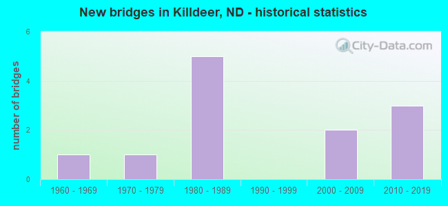
- New bridges - historical statistics
- 11960-1969
- 11970-1979
- 51980-1989
- 22000-2009
- 32010-2019

- Reconstructed bridges - Historical Statistics
- 12000-2009
- 22010-2019


- Bridge Condition - Deck
- 33.3%Very good
- 33.3%Good
- 33.3%Satisfactory

- Bridge Condition - Substructure
- 33.3%Very good
- 66.7%Good

- Bridge Condition - Channel
- 41.7%Excellent
- 25.0%Very good
- 25.0%Good
- 8.3%Satisfactory

- Bridge Condition - Culverts
- 11.1%Excellent
- 22.2%Very good
- 66.7%Good
Find on map >> Show street view
Structure Number: 1311428, Location: 4 WEST 2 NORTH KILLDEER (Lat: 47.401042, Lng: -102.812117), Route carried "on" structure: County highway , Year Built: 1978, Status: Open, Structure Length: 0.64m (2.10ft), Average Daily Traffic: 70 (year 2018), Average Future Daily Traffic: 80 (year 2038), Design Load: H 20, Features Intersected: GUMBO CREEK, Facility Carried by Structure: COUNTY HIWAY
Minimum Vertical Clearance: 30+ m (98+ ft), Kilometerpoint: 0.000, Lanes on structure: 2, Owner: County Highway Agency, Approaching Roadway Width: 7.3m (24.0ft), Material/Design: Concrete, Design/Construction: Culvert, Number Of Spans In Main Unit: 2, Length of Maximum Span: 3.0m (9.8ft)
Condition: Channel: Very good, Culverts: Good, Operating Rating: 54.0 metric tons, Method Used To Determine Operating Rating: Load Factor (LF), Inventory Rating: 32.4 metric tons, Method Used To Determine Inventory Rating: Load Factor (LF), Structural Evaluation: Better than present minimum criteria, Waterway Adequacy: Equal to present desirable criteria, Approach Roadway Alignment: Equal to present desirable criteria, Designated Inspection Frequency: Every 48 months, Inspection Date: June 2021
Find on map >> Show street view
Structure Number: 131173, Location: EAST OF KILLDEER (Lat: 47.372064, Lng: -102.739664), Route carried "on" structure: County highway , Year Built: 1989, Status: Open, Structure Length: 1.65m (5.41ft), Average Daily Traffic: 60 (year 2018), Average Future Daily Traffic: 70 (year 2038), Design Load: HS 20, Features Intersected: SPRING CREEK, Facility Carried by Structure: COUNTY HIWAY
Minimum Vertical Clearance: 30+ m (98+ ft), Kilometerpoint: 0.000, Lanes on structure: 2, Owner: County Highway Agency, Approaching Roadway Width: 7.3m (24.0ft), Material/Design: Prestressed concrete, Design/Construction: Box Beam or Girders - Single/Spread, Number Of Spans In Main Unit: 1, Length of Maximum Span: 15.2m (49.9ft), Curb-To-Curb Width: 8.6m (28.2ft), Out-to-Out Width: 9.8m (32.2ft)
Condition: Deck: Very good, Superstructure: Very good, Substructure: Good, Channel: Very good, Operating Rating: 49.6 metric tons, Method Used To Determine Operating Rating: Load Factor (LF), Inventory Rating: 27.8 metric tons, Method Used To Determine Inventory Rating: Load Factor (LF), Structural Evaluation: Equal to present minimum criteria, Deck Geometry: Better than present minimum criteria, Waterway Adequacy: Equal to present desirable criteria, Approach Roadway Alignment: Equal to present desirable criteria, Designated Inspection Frequency: Every 24 months, Inspection Date: June 2021, Deck Structure Type: Concrete Cast-file-Place, Wearing Surface/Protective System: Wearing Surface: Monolithic Concrete
Find on map >> Show street view
Structure Number: 13117301, Location: 1 EAST OF KILLDEER (Lat: 47.375706, Lng: -102.737192), Route carried "on" structure: County highway , Year Built: 2007, Status: Open, Structure Length: 1.37m (4.49ft), Average Daily Traffic: 25 (year 2018), Average Future Daily Traffic: 30 (year 2038), Design Load: HS 25 or greater, Features Intersected: SPRING CREEK, Facility Carried by Structure: COUNTY HIWAY
Minimum Vertical Clearance: 30+ m (98+ ft), Kilometerpoint: 0.000, Lanes on structure: 2, Owner: County Highway Agency, Approaching Roadway Width: 6.1m (20.0ft), Material/Design: Concrete, Design/Construction: Culvert, Number Of Spans In Main Unit: 3, Length of Maximum Span: 4.3m (14.1ft)
Condition: Channel: Very good, Culverts: Good, Operating Rating: 67.5 metric tons, Method Used To Determine Operating Rating: Load Factor (LF), Inventory Rating: 40.5 metric tons, Method Used To Determine Inventory Rating: Load Factor (LF), Structural Evaluation: Better than present minimum criteria, Waterway Adequacy: Superior to present desirable criteria, Approach Roadway Alignment: Equal to present desirable criteria, Designated Inspection Frequency: Every 48 months, Inspection Date: June 2021
Find on map >> Show street view
Structure Number: 13117302, Location: 1 EAST 1 NORTH KILLDEER (Lat: 47.379119, Lng: -102.737219), Route carried "on" structure: County highway , Year Built: 2007, Status: Open, Structure Length: 1.55m (5.09ft), Average Daily Traffic: 25 (year 2018), Average Future Daily Traffic: 30 (year 2038), Design Load: HS 25 or greater, Features Intersected: CREEK, Facility Carried by Structure: COUNTY HIWAY
Minimum Vertical Clearance: 30+ m (98+ ft), Kilometerpoint: 0.000, Lanes on structure: 2, Owner: County Highway Agency, Approaching Roadway Width: 6.1m (20.0ft), Material/Design: Concrete, Design/Construction: Culvert, Number Of Spans In Main Unit: 4, Length of Maximum Span: 3.7m (12.1ft)
Condition: Channel: Excellent, Culverts: Good, Operating Rating: 67.5 metric tons, Method Used To Determine Operating Rating: Load Factor (LF), Inventory Rating: 40.5 metric tons, Method Used To Determine Inventory Rating: Load Factor (LF), Structural Evaluation: Better than present minimum criteria, Waterway Adequacy: Superior to present desirable criteria, Approach Roadway Alignment: Equal to present desirable criteria, Designated Inspection Frequency: Every 48 months, Inspection Date: June 2021
Find on map >> Show street view
Structure Number: 22100919, Location: 4 SOUTH OF ND 200 (Lat: 47.305425, Lng: -102.757797), Route carried "on" structure: State highway 22, Year Built: 1986, Year Reconstructed: 2015, Status: Open, Structure Length: 0.76m (2.49ft), Average Daily Traffic: 1,610 (year 2019), Truck Traffic: 10%, Average Future Daily Traffic: 1,570 (year 2039), Design Load: HS 20, Features Intersected: CREEK
Minimum Vertical Clearance: 30+ m (98+ ft), Kilometerpoint: 162.379, Lanes on structure: 2, Base Highway Network: Yes, Owner: State Highway Agency, Approaching Roadway Width: 14.6m (47.9ft), Skew: 3 degrees, Material/Design: Concrete, Design/Construction: Culvert, Number Of Spans In Main Unit: 3, Length of Maximum Span: 2.1m (6.9ft)
Condition: Channel: Good, Culverts: Good, Operating Rating: 54.0 metric tons, Method Used To Determine Operating Rating: Load Factor (LF), Inventory Rating: 32.4 metric tons, Method Used To Determine Inventory Rating: Load Factor (LF), Structural Evaluation: Better than present minimum criteria, Waterway Adequacy: Better than present minimum criteria, Approach Roadway Alignment: Equal to present desirable criteria, Designated Inspection Frequency: Every 48 months, Inspection Date: June 2019
Find on map >> Show street view
Structure Number: 22101569, Location: 3 SOUTH OF KILLDEER (Lat: 47.314806, Lng: -102.757819), Route carried "on" structure: State highway 22, Year Built: 1986, Year Reconstructed: 2015, Status: Open, Structure Length: 0.76m (2.49ft), Average Daily Traffic: 1,630 (year 2019), Truck Traffic: 10%, Average Future Daily Traffic: 1,570 (year 2039), Design Load: HS 20, Features Intersected: MURPHY CREEK
Minimum Vertical Clearance: 30+ m (98+ ft), Kilometerpoint: 163.425, Lanes on structure: 2, Base Highway Network: Yes, Owner: State Highway Agency, Approaching Roadway Width: 20.7m (67.9ft), Material/Design: Concrete, Design/Construction: Culvert, Number Of Spans In Main Unit: 3, Length of Maximum Span: 2.4m (7.9ft)
Condition: Channel: Good, Culverts: Good, Operating Rating: 54.0 metric tons, Method Used To Determine Operating Rating: Load Factor (LF), Inventory Rating: 32.4 metric tons, Method Used To Determine Inventory Rating: Load Factor (LF), Structural Evaluation: Better than present minimum criteria, Waterway Adequacy: Equal to present desirable criteria, Approach Roadway Alignment: Better than present minimum criteria, Designated Inspection Frequency: Every 48 months, Inspection Date: June 2019
Find on map >> Show street view
Structure Number: 22102754, Location: 2 SOUTH OF KILLDEER (Lat: 47.331667, Lng: -102.758333), Route carried "on" structure: State highway 22, Year Built: 1986, Status: Open, Structure Length: 1.95m (6.40ft), Average Daily Traffic: 1,680 (year 2019), Truck Traffic: 10%, Average Future Daily Traffic: 1,570 (year 2039), Design Load: HS 20, Features Intersected: CREEK
Minimum Vertical Clearance: 30+ m (98+ ft), Kilometerpoint: 165.331, Lanes on structure: 2, Base Highway Network: Yes, Owner: State Highway Agency, Approaching Roadway Width: 12.2m (40.0ft), Material/Design: Prestressed concrete, Design/Construction: Box Beam or Girders - Single/Spread, Number Of Spans In Main Unit: 1, Length of Maximum Span: 18.3m (60.0ft), Curb-To-Curb Width: 12.2m (40.0ft), Out-to-Out Width: 13.0m (42.7ft)
Condition: Deck: Good, Superstructure: Very good, Substructure: Very good, Channel: Satisfactory, Operating Rating: 82.3 metric tons, Method Used To Determine Operating Rating: Load Factor (LF), Inventory Rating: 36.7 metric tons, Method Used To Determine Inventory Rating: Load Factor (LF), Structural Evaluation: Equal to present desirable criteria, Deck Geometry: Better than present minimum criteria, Waterway Adequacy: Equal to present desirable criteria, Approach Roadway Alignment: Equal to present desirable criteria, Designated Inspection Frequency: Every 24 months, Inspection Date: September 2020, Deck Structure Type: Concrete Cast-file-Place, Wearing Surface/Protective System: Wearing Surface: Monolithic Concrete, Deck Protection: Epoxy Coated Reinforcing
Find on map >> Show street view
Structure Number: 22106348, Location: 2 WEST OF KILLDEER (Lat: 47.366939, Lng: -102.801153), Route carried "on" structure: State highway 22, Year Built: 2016, Status: Open, Structure Length: 0.81m (2.66ft), Average Daily Traffic: 900 (year 2019), Truck Traffic: 60%, Average Future Daily Traffic: 6,330 (year 2039), Design Load: HS 25 or greater, Features Intersected: SPRING CREEK
Minimum Vertical Clearance: 30+ m (98+ ft), Kilometerpoint: 171.151, Lanes on structure: 2, Base Highway Network: Yes, Owner: State Highway Agency, Approaching Roadway Width: 12.2m (40.0ft), Skew: 2 degrees, Material/Design: Concrete, Design/Construction: Culvert, Number Of Spans In Main Unit: 2, Length of Maximum Span: 3.9m (12.8ft)
Condition: Channel: Excellent, Culverts: Very good, Operating Rating: 68.0 metric tons, Method Used To Determine Operating Rating: Load Factor (LF), Inventory Rating: 40.8 metric tons, Method Used To Determine Inventory Rating: Load Factor (LF), Structural Evaluation: Equal to present desirable criteria, Waterway Adequacy: Equal to present desirable criteria, Approach Roadway Alignment: Equal to present desirable criteria, Designated Inspection Frequency: Every 48 months, Inspection Date: June 2019
Find on map >> Show street view
Structure Number: 22108432, Location: 2 W 3 NORTH OF KILLDEER (Lat: 47.381600, Lng: -102.757600), Route carried "on" structure: State highway 22, Year Built: 2016, Status: Open, Structure Length: 1.07m (3.51ft), Average Daily Traffic: 900 (year 2019), Truck Traffic: 60%, Average Future Daily Traffic: 6,330 (year 2039), Design Load: HS 25 or greater, Features Intersected: GUMBO CREEK
Minimum Vertical Clearance: 30+ m (98+ ft), Kilometerpoint: 174.504, Lanes on structure: 2, Base Highway Network: Yes, Owner: State Highway Agency, Approaching Roadway Width: 12.2m (40.0ft), Skew: 4 degrees, Material/Design: Concrete, Design/Construction: Culvert, Number Of Spans In Main Unit: 2, Length of Maximum Span: 5.2m (17.1ft)
Condition: Channel: Excellent, Culverts: Very good, Operating Rating: 68.0 metric tons, Method Used To Determine Operating Rating: Load Factor (LF), Inventory Rating: 40.8 metric tons, Method Used To Determine Inventory Rating: Load Factor (LF), Structural Evaluation: Equal to present desirable criteria, Waterway Adequacy: Equal to present desirable criteria, Approach Roadway Alignment: Equal to present desirable criteria, Designated Inspection Frequency: Every 48 months, Inspection Date: June 2019
Find on map >> Show street view
Structure Number: 2294084, Location: SOUTH LIMITS OF KILLDEER (Lat: 47.362000, Lng: -102.758600), Route carried "on" structure: State highway 22, Year Built: 1986, Status: Open, Structure Length: 1.95m (6.40ft), Average Daily Traffic: 2,420 (year 2019), Truck Traffic: 6%, Average Future Daily Traffic: 2,671 (year 2039), Design Load: HS 20, Features Intersected: SPRING CREEK
Minimum Vertical Clearance: 30+ m (98+ ft), Kilometerpoint: 168.688, Lanes on structure: 2, Base Highway Network: Yes, Owner: State Highway Agency, Approaching Roadway Width: 8.5m (27.9ft), Material/Design: Prestressed concrete, Design/Construction: Box Beam or Girders - Single/Spread, Number Of Spans In Main Unit: 1, Length of Maximum Span: 18.3m (60.0ft), Curb-To-Curb Width: 12.2m (40.0ft), Out-to-Out Width: 13.0m (42.7ft)
Condition: Deck: Satisfactory, Superstructure: Very good, Substructure: Good, Channel: Good, Operating Rating: 82.3 metric tons, Method Used To Determine Operating Rating: Load Factor (LF), Inventory Rating: 36.7 metric tons, Method Used To Determine Inventory Rating: Load Factor (LF), Structural Evaluation: Better than present minimum criteria, Deck Geometry: Equal to present minimum criteria, Waterway Adequacy: Equal to present desirable criteria, Approach Roadway Alignment: Equal to present desirable criteria, Designated Inspection Frequency: Every 24 months, Inspection Date: September 2020, Deck Structure Type: Concrete Cast-file-Place, Wearing Surface/Protective System: Wearing Surface: Monolithic Concrete, Deck Protection: Epoxy Coated Reinforcing
Find on map >> Show street view
Structure Number: 22942595, Location: 1 NORTH OF KILLDEER (Lat: 47.381600, Lng: -102.757600), Route carried "on" structure: State highway 22, Year Built: 1965, Year Reconstructed: 2011, Status: Open, Structure Length: 1.28m (4.20ft), Average Daily Traffic: 900 (year 2019), Truck Traffic: 8%, Average Future Daily Traffic: 741 (year 2039), Design Load: HS 20, Features Intersected: GUMBO CREEK
Minimum Vertical Clearance: 30+ m (98+ ft), Kilometerpoint: 171.511, Lanes on structure: 2, Base Highway Network: Yes, Owner: State Highway Agency, Approaching Roadway Width: 12.2m (40.0ft), Material/Design: Concrete, Design/Construction: Culvert, Number Of Spans In Main Unit: 4, Length of Maximum Span: 3.0m (9.8ft)
Condition: Channel: Excellent, Culverts: Good, Operating Rating: 54.0 metric tons, Method Used To Determine Operating Rating: Load Factor (LF), Inventory Rating: 32.4 metric tons, Method Used To Determine Inventory Rating: Load Factor (LF), Structural Evaluation: Better than present minimum criteria, Waterway Adequacy: Better than present minimum criteria, Approach Roadway Alignment: Somewhat better than minimum adequacy, Designated Inspection Frequency: Every 48 months, Inspection Date: June 2019
Find on map >> Show street view
Structure Number: 200093116, Location: 2 WEST OF ND 22 (Lat: 47.357622, Lng: -102.804208), Route carried "on" structure: State highway 200, Year Built: 2016, Status: Open, Structure Length: 1.74m (5.71ft), Average Daily Traffic: 2,980 (year 2019), Truck Traffic: 45%, Average Future Daily Traffic: 5,190 (year 2039), Design Load: HS 25 or greater, Features Intersected: SPRING CREEK
Minimum Vertical Clearance: 30+ m (98+ ft), Kilometerpoint: 149.824, Lanes on structure: 2, Base Highway Network: Yes, Owner: State Highway Agency, Approaching Roadway Width: 8.2m (26.9ft), Skew: 3 degrees, Material/Design: Concrete, Design/Construction: Culvert, Number Of Spans In Main Unit: 4, Length of Maximum Span: 4.0m (13.1ft)
Condition: Channel: Excellent, Culverts: Excellent, Operating Rating: 68.0 metric tons, Method Used To Determine Operating Rating: Load Factor (LF), Inventory Rating: 40.8 metric tons, Method Used To Determine Inventory Rating: Load Factor (LF), Structural Evaluation: Superior to present desirable criteria, Waterway Adequacy: Equal to present desirable criteria, Approach Roadway Alignment: Somewhat better than minimum adequacy, Designated Inspection Frequency: Every 48 months, Inspection Date: July 2019