Bridge Statistics for Killen, Alabama (AL)
Condition, Traffic, Stress, Structural Evaluation, Project Costs
- National Bridge Inventory (NBI) Statistics
- 12Number of bridges
- 46ft / 14.3mTotal length
- $10,713,000Total costs
- 85,425Total average daily traffic
- 4,960Total average daily truck traffic
- 106,382Total future (year 2028) average daily traffic
- National Bridge Inventory (NBI) Registered Bridges for Killen
- No street view available for this location
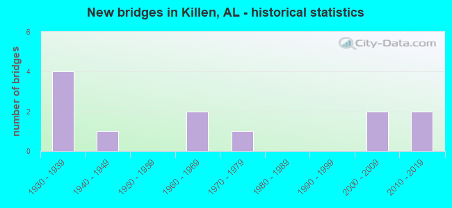
- New bridges - historical statistics
- 41930-1939
- 11940-1949
- 21960-1969
- 11970-1979
- 22000-2009
- 22010-2019


- Bridge Condition - Deck
- 50.0%Satisfactory
- 25.0%Fair
- 25.0%Poor

- Bridge Condition - Superstructure
- 50.0%Satisfactory
- 25.0%Fair
- 25.0%Poor

- Bridge Condition - Substructure
- 25.0%Satisfactory
- 50.0%Fair
- 25.0%Poor

- Bridge Condition - Channel
- 16.7%Very good
- 58.3%Good
- 25.0%Satisfactory

- Bridge Condition - Culverts
- 12.5%Excellent
- 25.0%Very good
- 12.5%Good
- 37.5%Satisfactory
- 12.5%Fair
Find on map >> Show street view
Structure Number: 1578, Location: 1.3 MI N OF CO 71 (Lat: 34.908394, Lng: -87.477675), Route carried "on" structure: County highway 31, Year Built: 1937, Status: Posted for load, Structure Length: 0.73m (2.40ft), Average Daily Traffic: 150 (year 1989), Truck Traffic: 10%, Average Future Daily Traffic: 300 (year 2031), Features Intersected: CAMP BRANCH
Minimum Vertical Clearance: 30+ m (98+ ft), Kilometerpoint: 0.010, Lanes on structure: 2, Owner: County Highway Agency, Approaching Roadway Width: 7.9m (25.9ft), Material/Design: Concrete, Design/Construction: Tee Beam, Number Of Spans In Main Unit: 1, Length of Maximum Span: 7.3m (24.0ft), Curb or Sidewalk Widths: Left: 0.5m (1.6ft), Right: 0.5m (1.6ft), Curb-To-Curb Width: 5.4m (17.7ft), Out-to-Out Width: 5.7m (18.7ft)
Condition: Deck: Fair, Superstructure: Fair, Substructure: Fair, Channel: Satisfactory, Operating Rating: 18.1 metric tons, Method Used To Determine Operating Rating: Field evaluation and documented engineering judgment, Inventory Rating: 16.3 metric tons, Method Used To Determine Inventory Rating: Field evaluation and documented engineering judgment, Structural Evaluation: Somewhat better than minimum adequacy, Waterway Adequacy: Equal to present minimum criteria, Approach Roadway Alignment: Equal to present minimum criteria, Bridge Posting: Required (Relationship of Operating Rating to Maximum Legal Load: > 39.9% below), Length Of Structure Improvement: 1.38m (4.53ft), Designated Inspection Frequency: Every 24 months, Other Special Inspection Frequency: Every 12 months, Inspection Date: Febuary 2021, Other Special Inspection Date: Febuary 2022, Bridge Improvement Cost: $170,000, Roadway Improvement Cost: $17,000, Total Project Cost: $187,000 ( Estimate for 2022), Deck Structure Type: Concrete Cast-file-Place, Wearing Surface/Protective System: Wearing Surface: Bituminous
Find on map >> Show street view
Structure Number: 1793, Location: .3 MI E SCHOOL LANEKILLEN (Lat: 34.861317, Lng: -87.524361), Route carried "on" structure: County highway 66, Year Built: 1938, Status: Open, Structure Length: 3.17m (10.40ft), Average Daily Traffic: 410 (year 1989), Truck Traffic: 10%, Average Future Daily Traffic: 820 (year 2028), Features Intersected: SIX MILE CREEK
Minimum Vertical Clearance: 30+ m (98+ ft), Kilometerpoint: 0.010, Lanes on structure: 2, Owner: County Highway Agency, Approaching Roadway Width: 9.4m (30.8ft), Skew: 1 degrees, Material/Design: Concrete, Design/Construction: Tee Beam, Number Of Spans In Main Unit: 3, Length of Maximum Span: 10.4m (34.1ft), Curb or Sidewalk Widths: Left: 0.4m (1.3ft), Right: 0.4m (1.3ft), Curb-To-Curb Width: 7.3m (24.0ft), Out-to-Out Width: 8.1m (26.6ft)
Condition: Deck: Satisfactory, Superstructure: Satisfactory, Substructure: Satisfactory, Channel: Good, Operating Rating: 32.7 metric tons, Method Used To Determine Operating Rating: Field evaluation and documented engineering judgment, Inventory Rating: 23.9 metric tons, Method Used To Determine Inventory Rating: Field evaluation and documented engineering judgment, Structural Evaluation: Equal to present minimum criteria, Waterway Adequacy: Equal to present desirable criteria, Approach Roadway Alignment: Better than present minimum criteria, Length Of Structure Improvement: 4.03m (13.22ft), Designated Inspection Frequency: Every 24 months, Inspection Date: May 2020, Bridge Improvement Cost: $719,000, Roadway Improvement Cost: $72,000, Total Project Cost: $791,000 ( Estimate for 2022), Deck Structure Type: Concrete Cast-file-Place, Wearing Surface/Protective System: Wearing Surface: Bituminous
Find on map >> Show street view
Structure Number: 2401, Location: 0.8 MI S INT CO 63 (Lat: 34.890144, Lng: -87.539794), Route carried "on" structure: County highway 65, Year Built: 1940, Status: Posted for load, Structure Length: 0.73m (2.40ft), Average Daily Traffic: 804 (year 2001), Truck Traffic: 10%, Average Future Daily Traffic: 1,195 (year 2031), Features Intersected: BRANCH
Minimum Vertical Clearance: 30+ m (98+ ft), Kilometerpoint: 0.010, Lanes on structure: 2, Owner: County Highway Agency, Approaching Roadway Width: 7.9m (25.9ft), Skew: 3 degrees, Material/Design: Concrete, Design/Construction: Slab, Number Of Spans In Main Unit: 1, Length of Maximum Span: 7.3m (24.0ft), Curb or Sidewalk Widths: Left: 0.3m (1.0ft), Right: 0.3m (1.0ft), Curb-To-Curb Width: 7.9m (25.9ft), Out-to-Out Width: 8.4m (27.6ft)
Condition: Deck: Poor, Superstructure: Poor, Substructure: Poor, Channel: Satisfactory, Operating Rating: 5.4 metric tons, Method Used To Determine Operating Rating: Field evaluation and documented engineering judgment, Inventory Rating: 3.6 metric tons, Method Used To Determine Inventory Rating: Field evaluation and documented engineering judgment, Structural Evaluation: High priority of replacement, Waterway Adequacy: Somewhat better than minimum adequacy, Approach Roadway Alignment: Better than present minimum criteria, Bridge Posting: Required (Relationship of Operating Rating to Maximum Legal Load: > 39.9% below), Length Of Structure Improvement: 1.38m (4.53ft), Designated Inspection Frequency: Every 24 months, Other Special Inspection Frequency: Every 12 months, Inspection Date: November 2020, Other Special Inspection Date: November 2021, Bridge Improvement Cost: $255,000, Roadway Improvement Cost: $26,000, Total Project Cost: $281,000 ( Estimate for 2022), Deck Structure Type: Concrete Cast-file-Place, Wearing Surface/Protective System: Wearing Surface: Bituminous
Find on map >> Show street view
Structure Number: 6909, Location: 1.7 MI E JCT SR 2 & SR 13 (Lat: 34.859431, Lng: -87.527267), Route carried "on" structure: US 72, Year Built: 1960, Status: Open, Structure Length: 1.19m (3.90ft), Average Daily Traffic: 23,230 (year 2020), Truck Traffic: 6%, Average Future Daily Traffic: 28,233 (year 2033), Design Load: HS 20, Features Intersected: SIX MILE CREEK, Facility Carried by Structure: SR 2
Minimum Vertical Clearance: 30+ m (98+ ft), Kilometerpoint: 67.959, Lanes on structure: 4, Base Highway Network: Yes, Owner: State Highway Agency, Approaching Roadway Width: 21.0m (68.9ft), Skew: 13 degrees, Material/Design: Concrete, Design/Construction: Culvert, Number Of Spans In Main Unit: 3, Length of Maximum Span: 3.0m (9.8ft)
Condition: Channel: Good, Culverts: Satisfactory, Operating Rating: 88.9 metric tons, Method Used To Determine Operating Rating: Load Factor (LF), Inventory Rating: 88.9 metric tons, Method Used To Determine Inventory Rating: Load Factor (LF), Structural Evaluation: Equal to present minimum criteria, Waterway Adequacy: Equal to present desirable criteria, Approach Roadway Alignment: Equal to present desirable criteria, Length Of Structure Improvement: 1.86m (6.10ft), Designated Inspection Frequency: Every 24 months, Inspection Date: Febuary 2022, Bridge Improvement Cost: $2,924,000, Roadway Improvement Cost: $292,000, Total Project Cost: $3,216,000 ( Estimate for 2022)
Find on map >> Show street view
Structure Number: 691, Location: 2.1 MI E JCT SR 2 & SR13 (Lat: 34.859714, Lng: -87.521114), Route carried "on" structure: US 72, Year Built: 1960, Status: Open, Structure Length: 0.94m (3.08ft), Average Daily Traffic: 23,230 (year 2020), Truck Traffic: 6%, Average Future Daily Traffic: 28,233 (year 2033), Design Load: HS 20, Features Intersected: BRANCH, Facility Carried by Structure: SR 2
Minimum Vertical Clearance: 7.56m (24.80ft), Kilometerpoint: 68.531, Lanes on structure: 4, Base Highway Network: Yes, Owner: State Highway Agency, Approaching Roadway Width: 21.0m (68.9ft), Skew: 14 degrees, Material/Design: Concrete, Design/Construction: Culvert, Number Of Spans In Main Unit: 2, Length of Maximum Span: 3.0m (9.8ft)
Condition: Channel: Good, Culverts: Satisfactory, Operating Rating: 88.9 metric tons, Method Used To Determine Operating Rating: Load Factor (LF), Inventory Rating: 88.9 metric tons, Method Used To Determine Inventory Rating: Load Factor (LF), Structural Evaluation: Equal to present minimum criteria, Waterway Adequacy: Equal to present desirable criteria, Approach Roadway Alignment: Equal to present desirable criteria, Length Of Structure Improvement: 1.61m (5.28ft), Designated Inspection Frequency: Every 24 months, Inspection Date: Febuary 2022, Bridge Improvement Cost: $1,941,000, Roadway Improvement Cost: $194,000, Total Project Cost: $2,135,000 ( Estimate for 2022)
Find on map >> Show street view
Structure Number: 8949, Location: 4 MI E JCT SR 2 & SR 13 (Lat: 34.859581, Lng: -87.484675), Route carried "on" structure: US 72, Year Built: 1936, Year Reconstructed: 1966, Status: Open, Structure Length: 0.76m (2.49ft), Average Daily Traffic: 17,560 (year 2022), Truck Traffic: 7%, Average Future Daily Traffic: 21,342 (year 2033), Design Load: H 20, Features Intersected: FOUR MILE CREEK, Facility Carried by Structure: SR 2
Minimum Vertical Clearance: 7.56m (24.80ft), Kilometerpoint: 71.888, Lanes on structure: 4, Base Highway Network: Yes, Owner: State Highway Agency, Approaching Roadway Width: 12.2m (40.0ft), Skew: 19 degrees, Material/Design: Concrete, Design/Construction: Culvert, Number Of Spans In Main Unit: 2, Length of Maximum Span: 3.0m (9.8ft)
Condition: Channel: Good, Culverts: Satisfactory, Operating Rating: 88.9 metric tons, Method Used To Determine Operating Rating: Load Factor (LF), Inventory Rating: 88.9 metric tons, Method Used To Determine Inventory Rating: Load Factor (LF), Structural Evaluation: Equal to present minimum criteria, Waterway Adequacy: Equal to present minimum criteria, Approach Roadway Alignment: Equal to present desirable criteria, Length Of Structure Improvement: 1.41m (4.63ft), Designated Inspection Frequency: Every 24 months, Inspection Date: Febuary 2022, Bridge Improvement Cost: $821,000, Roadway Improvement Cost: $82,000, Total Project Cost: $903,000 ( Estimate for 2022)
Find on map >> Show street view
Structure Number: 895, Location: 4 M W JCT SR 2 & SR 101 (Lat: 34.861250, Lng: -87.460222), Route carried "on" structure: US 72, Year Built: 1936, Year Reconstructed: 1966, Status: Open, Structure Length: 0.70m (2.30ft), Average Daily Traffic: 17,560 (year 2022), Truck Traffic: 4%, Average Future Daily Traffic: 21,342 (year 2033), Design Load: H 20, Features Intersected: DRY BRANCH, Facility Carried by Structure: SR 2
Minimum Vertical Clearance: 7.56m (24.80ft), Kilometerpoint: 74.149, Lanes on structure: 4, Base Highway Network: Yes, Owner: State Highway Agency, Approaching Roadway Width: 19.0m (62.3ft), Skew: 10 degrees, Material/Design: Concrete, Design/Construction: Culvert, Number Of Spans In Main Unit: 4, Length of Maximum Span: 1.5m (4.9ft)
Condition: Channel: Good, Culverts: Fair, Operating Rating: 76.8 metric tons, Method Used To Determine Operating Rating: Load Factor (LF), Inventory Rating: 46.1 metric tons, Method Used To Determine Inventory Rating: Load Factor (LF), Structural Evaluation: Somewhat better than minimum adequacy, Waterway Adequacy: Equal to present minimum criteria, Approach Roadway Alignment: Equal to present desirable criteria, Length Of Structure Improvement: 1.34m (4.40ft), Designated Inspection Frequency: Every 24 months, Inspection Date: Febuary 2022, Bridge Improvement Cost: $789,000, Roadway Improvement Cost: $79,000, Total Project Cost: $868,000 ( Estimate for 2022)
Find on map >> Show street view
Structure Number: 11284, Location: 1.4 MI SE CO 25 (Lat: 34.884481, Lng: -87.506147), Route carried "on" structure: County highway 170, Year Built: 1974, Status: Open, Structure Length: 1.46m (4.79ft), Average Daily Traffic: 140 (year 1989), Truck Traffic: 10%, Average Future Daily Traffic: 280 (year 2030), Design Load: H 15, Features Intersected: SIX MILE CREEK
Minimum Vertical Clearance: 30+ m (98+ ft), Kilometerpoint: 0.010, Lanes on structure: 2, Owner: County Highway Agency, Approaching Roadway Width: 6.1m (20.0ft), Material/Design: Concrete, Design/Construction: Channel Beam, Number Of Spans In Main Unit: 2, Length of Maximum Span: 7.3m (24.0ft), Curb or Sidewalk Widths: Left: 0.2m (0.7ft), Right: 0.2m (0.7ft), Curb-To-Curb Width: 7.2m (23.6ft), Out-to-Out Width: 7.6m (24.9ft)
Condition: Deck: Satisfactory, Superstructure: Satisfactory, Substructure: Fair, Channel: Satisfactory, Operating Rating: 32.7 metric tons, Method Used To Determine Operating Rating: Field evaluation and documented engineering judgment, Inventory Rating: 23.9 metric tons, Method Used To Determine Inventory Rating: Field evaluation and documented engineering judgment, Structural Evaluation: Somewhat better than minimum adequacy, Waterway Adequacy: Better than present minimum criteria, Approach Roadway Alignment: Equal to present minimum criteria, Length Of Structure Improvement: 2.14m (7.02ft), Designated Inspection Frequency: Every 24 months, Inspection Date: Febuary 2021, Bridge Improvement Cost: $367,000, Roadway Improvement Cost: $37,000, Total Project Cost: $404,000 ( Estimate for 2022), Deck Structure Type: Concrete Precast Panels
Find on map >> Show street view
Structure Number: 19766, Location: 1.8 MI SE INT CO 71 (Lat: 34.887064, Lng: -87.448592), Route carried "on" structure: County highway 68, Year Built: 2006, Status: Open, Structure Length: 0.82m (2.69ft), Average Daily Traffic: 215 (year 1989), Average Future Daily Traffic: 430 (year 2028), Design Load: HS 20, Features Intersected: MCPETERS BRANCH, Facility Carried by Structure: CO RD 69
Minimum Vertical Clearance: 30+ m (98+ ft), Kilometerpoint: 0.010, Lanes on structure: 2, Owner: County Highway Agency, Approaching Roadway Width: 6.1m (20.0ft), Skew: 1 degrees, Material/Design: Concrete, Design/Construction: Culvert, Number Of Spans In Main Unit: 2, Length of Maximum Span: 3.8m (12.5ft), Curb or Sidewalk Widths: Left: 0.3m (1.0ft), Right: 0.3m (1.0ft), Curb-To-Curb Width: 8.6m (28.2ft), Out-to-Out Width: 9.1m (29.9ft)
Condition: Channel: Good, Culverts: Very good, Operating Rating: 88.9 metric tons, Method Used To Determine Operating Rating: Load Factor (LF), Inventory Rating: 57.2 metric tons, Method Used To Determine Inventory Rating: Load Factor (LF), Structural Evaluation: Equal to present desirable criteria, Deck Geometry: Equal to present minimum criteria, Waterway Adequacy: Better than present minimum criteria, Approach Roadway Alignment: Better than present minimum criteria, Length Of Structure Improvement: 1.47m (4.82ft), Designated Inspection Frequency: Every 24 months, Inspection Date: Febuary 2021, Bridge Improvement Cost: $264,000, Roadway Improvement Cost: $26,000, Total Project Cost: $290,000 ( Estimate for 2022)
Find on map >> Show street view
Structure Number: 19956, Location: 0.2 MI WEST INT US 43 (Lat: 34.874008, Lng: -87.545606), Route carried "on" structure: County highway 63, Year Built: 2007, Status: Open, Structure Length: 1.74m (5.71ft), Average Daily Traffic: 708 (year 2001), Average Future Daily Traffic: 991 (year 2029), Design Load: HS 20, Features Intersected: BRUSH CREEK
Minimum Vertical Clearance: 30+ m (98+ ft), Kilometerpoint: 0.010, Lanes on structure: 2, Owner: County Highway Agency, Approaching Roadway Width: 6.1m (20.0ft), Skew: 3 degrees, Material/Design: Concrete, Design/Construction: Culvert, Number Of Spans In Main Unit: 4, Length of Maximum Span: 4.2m (13.8ft), Curb or Sidewalk Widths: Left: 0.3m (1.0ft), Right: 0.3m (1.0ft), Curb-To-Curb Width: 9.2m (30.2ft), Out-to-Out Width: 9.8m (32.2ft)
Condition: Channel: Good, Culverts: Very good, Operating Rating: 68.2 metric tons, Method Used To Determine Operating Rating: Load Factor (LF), Inventory Rating: 40.9 metric tons, Method Used To Determine Inventory Rating: Load Factor (LF), Structural Evaluation: Equal to present desirable criteria, Deck Geometry: Equal to present minimum criteria, Waterway Adequacy: Better than present minimum criteria, Approach Roadway Alignment: Better than present minimum criteria, Length Of Structure Improvement: 2.45m (8.04ft), Designated Inspection Frequency: Every 24 months, Inspection Date: October 2021, Bridge Improvement Cost: $523,000, Roadway Improvement Cost: $52,000, Total Project Cost: $575,000 ( Estimate for 2022), Deck Structure Type: Concrete Cast-file-Place
Find on map >> Show street view
Structure Number: 20781, Location: 2.4 MI E JCT SR 2 & SR 13 (Lat: 34.859458, Lng: -87.516094), Route carried "on" structure: County highway 71, Year Built: 2013, Status: Open, Structure Length: 0.77m (2.53ft), Average Daily Traffic: 600 (year 2022), Truck Traffic: 2%, Average Future Daily Traffic: 1,200 (year 2033), Design Load: HS 20, Features Intersected: BRANCH, Facility Carried by Structure: LINGERLOST ROAD
Minimum Vertical Clearance: 30+ m (98+ ft), Kilometerpoint: 69.014, Lanes on structure: 2, Owner: State Highway Agency, Approaching Roadway Width: 5.8m (19.0ft), Material/Design: Steel, Design/Construction: Culvert, Number Of Spans In Main Unit: 3, Length of Maximum Span: 2.4m (7.9ft), Curb-To-Curb Width: 17.9m (58.7ft), Out-to-Out Width: 18.5m (60.7ft)
Condition: Channel: Very good, Culverts: Good, Operating Rating: 39.6 metric tons, Method Used To Determine Operating Rating: Load Factor (LF), Inventory Rating: 32.7 metric tons, Method Used To Determine Inventory Rating: Load Factor (LF), Structural Evaluation: Better than present minimum criteria, Deck Geometry: Superior to present desirable criteria, Waterway Adequacy: Superior to present desirable criteria, Approach Roadway Alignment: Equal to present desirable criteria, Length Of Structure Improvement: 1.42m (4.66ft), Designated Inspection Frequency: Every 24 months, Inspection Date: Febuary 2022, Bridge Improvement Cost: $493,000, Roadway Improvement Cost: $49,000, Total Project Cost: $542,000 ( Estimate for 2022)
Find on map >> Show street view
Structure Number: 20958, Location: 3.5 Mi N of US 72 (Lat: 34.905294, Lng: -87.515456), Route carried "on" structure: County highway 25, Year Built: 2016, Status: Open, Structure Length: 1.28m (4.20ft), Average Daily Traffic: 818 (year 2001), Truck Traffic: 10%, Average Future Daily Traffic: 2,016 (year 2031), Design Load: HS 20, Features Intersected: Six Mile Creek
Minimum Vertical Clearance: 30+ m (98+ ft), Kilometerpoint: 0.010, Lanes on structure: 2, Owner: County Highway Agency, Approaching Roadway Width: 9.1m (29.9ft), Material/Design: Concrete, Design/Construction: Culvert, Number Of Spans In Main Unit: 3, Length of Maximum Span: 3.0m (9.8ft), Curb or Sidewalk Widths: Left: 0.3m (1.0ft), Right: 0.3m (1.0ft), Out-to-Out Width: 12.8m (42.0ft)
Condition: Channel: Very good, Culverts: Excellent, Operating Rating: 87.5 metric tons, Method Used To Determine Operating Rating: Load Factor (LF), Inventory Rating: 52.5 metric tons, Method Used To Determine Inventory Rating: Load Factor (LF), Structural Evaluation: Superior to present desirable criteria, Waterway Adequacy: Equal to present desirable criteria, Approach Roadway Alignment: Somewhat better than minimum adequacy, Length Of Structure Improvement: 1.95m (6.40ft), Designated Inspection Frequency: Every 24 months, Inspection Date: April 2020, Bridge Improvement Cost: $474,000, Roadway Improvement Cost: $47,000, Total Project Cost: $521,000 ( Estimate for 2022), Deck Structure Type: Concrete Cast-file-Place