Bridge Statistics for Kimball, South Dakota (SD)
Condition, Traffic, Stress, Structural Evaluation, Project Costs
- National Bridge Inventory (NBI) Statistics
- 10Number of bridges
- 85ft / 25.9mTotal length
- 28,681Total average daily traffic
- 6,201Total average daily truck traffic
- National Bridge Inventory (NBI) Registered Bridges for Kimball
- No street view available for this location
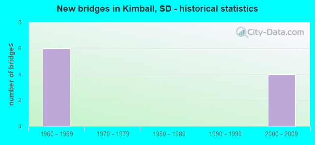
- New bridges - historical statistics
- 61960-1969
- 42000-2009


- Bridge Condition - Deck
- 60.0%Good
- 40.0%Satisfactory

- Bridge Condition - Superstructure
- 60.0%Very good
- 40.0%Satisfactory
Find on map >> Show street view
Structure Number: 823013, Location: 2.9 W SD 45 N INTERCH (Lat: 43.745194, Lng: -99.014044), Route carried "on" structure: Interstate 90, Year Built: 2006, Status: Open, Structure Length: 5.27m (17.29ft), Average Daily Traffic: 4,245 (year 2021), Truck Traffic: 23%, Average Future Daily Traffic: 6,143 (year 2041), Design Load: HS 25 or greater, Features Intersected: 251 ST
Minimum Vertical Clearance: 30+ m (98+ ft), Kilometerpoint: 452.435, Lanes on structure: 2, Lanes under structure: 2, Base Highway Network: Yes, Owner: State Highway Agency, Approaching Roadway Width: 11.6m (38.1ft), Skew: 3 degrees, Material/Design: Prestressed concrete continuous, Design/Construction: Stringer/Multi-beam, Number Of Spans In Main Unit: 3, Length of Maximum Span: 19.2m (63.0ft), Curb-To-Curb Width: 12.2m (40.0ft), Out-to-Out Width: 13.0m (42.7ft)
Condition: Deck: Good, Superstructure: Very good, Substructure: Good, Operating Rating: 55.9 metric tons, Method Used To Determine Operating Rating: Load Factor (LF), Inventory Rating: 33.5 metric tons, Method Used To Determine Inventory Rating: Load Factor (LF), Structural Evaluation: Better than present minimum criteria, Deck Geometry: Better than present minimum criteria, Underclear: Equal to present desirable criteria, Approach Roadway Alignment: Superior to present desirable criteria, Designated Inspection Frequency: Every 24 months, Inspection Date: December 2020, Deck Structure Type: Concrete Cast-file-Place, Wearing Surface/Protective System: Wearing Surface: Integral Concrete, Deck Protection: Epoxy Coated Reinforcing
Find on map >> Show street view
Structure Number: 8230131, Location: 2.9 W SD 45 N INTERCH (Lat: 43.745008, Lng: -99.014564), Route carried "on" structure: Interstate 90, Year Built: 2007, Status: Open, Structure Length: 5.27m (17.29ft), Average Daily Traffic: 4,245 (year 2021), Truck Traffic: 23%, Average Future Daily Traffic: 6,143 (year 2041), Design Load: HS 25 or greater, Features Intersected: 251 ST
Minimum Vertical Clearance: 30+ m (98+ ft), Kilometerpoint: 452.435, Lanes on structure: 2, Lanes under structure: 2, Base Highway Network: Yes, Owner: State Highway Agency, Approaching Roadway Width: 11.6m (38.1ft), Skew: 3 degrees, Material/Design: Prestressed concrete continuous, Design/Construction: Stringer/Multi-beam, Number Of Spans In Main Unit: 3, Length of Maximum Span: 19.2m (63.0ft), Curb-To-Curb Width: 12.2m (40.0ft), Out-to-Out Width: 13.0m (42.7ft)
Condition: Deck: Good, Superstructure: Very good, Substructure: Good, Operating Rating: 55.9 metric tons, Method Used To Determine Operating Rating: Load Factor (LF), Inventory Rating: 33.5 metric tons, Method Used To Determine Inventory Rating: Load Factor (LF), Structural Evaluation: Better than present minimum criteria, Deck Geometry: Better than present minimum criteria, Underclear: Meets minimum limits, Approach Roadway Alignment: Superior to present desirable criteria, Designated Inspection Frequency: Every 24 months, Inspection Date: December 2020, Deck Structure Type: Concrete Cast-file-Place, Wearing Surface/Protective System: Wearing Surface: Integral Concrete, Deck Protection: Epoxy Coated Reinforcing
Find on map >> Show street view
Structure Number: 8258135, Location: SD45N INTERCHANGE (Lat: 43.738172, Lng: -98.957956), Route carried "on" structure: Interstate 90, Year Built: 1963, Status: Open, Structure Length: 3.63m (11.91ft), Average Daily Traffic: 4,475 (year 2021), Truck Traffic: 24%, Average Future Daily Traffic: 6,475 (year 2041), Design Load: HS 20+Mod, Features Intersected: SD045
Minimum Vertical Clearance: 30+ m (98+ ft), Kilometerpoint: 457.150, Lanes on structure: 2, Lanes under structure: 2, Base Highway Network: Yes, Owner: State Highway Agency, Approaching Roadway Width: 11.6m (38.1ft), Material/Design: Concrete continuous, Design/Construction: Slab, Number Of Spans In Main Unit: 3, Length of Maximum Span: 13.1m (43.0ft), Curb-To-Curb Width: 11.6m (38.1ft), Out-to-Out Width: 12.9m (42.3ft)
Condition: Deck: Satisfactory, Superstructure: Satisfactory, Substructure: Good, Operating Rating: 65.8 metric tons, Method Used To Determine Operating Rating: Load Factor (LF), Inventory Rating: 39.4 metric tons, Method Used To Determine Inventory Rating: Load Factor (LF), Structural Evaluation: Equal to present minimum criteria, Deck Geometry: Equal to present minimum criteria, Underclear: Meets minimum limits, Approach Roadway Alignment: Equal to present desirable criteria, Designated Inspection Frequency: Every 24 months, Inspection Date: September 2021, Deck Structure Type: Concrete Cast-file-Place, Wearing Surface/Protective System: Wearing Surface: Epoxy Overlay, Membrane: Epoxy
Find on map >> Show street view
Structure Number: 8258136, Location: SD45N INTERCHANGE (Lat: 43.737942, Lng: -98.957950), Route carried "on" structure: Interstate 90, Year Built: 1963, Status: Open, Structure Length: 3.63m (11.91ft), Average Daily Traffic: 4,475 (year 2021), Truck Traffic: 24%, Average Future Daily Traffic: 6,475 (year 2041), Design Load: HS 20+Mod, Features Intersected: SD045
Minimum Vertical Clearance: 30+ m (98+ ft), Kilometerpoint: 457.150, Lanes on structure: 2, Lanes under structure: 2, Base Highway Network: Yes, Owner: State Highway Agency, Approaching Roadway Width: 11.6m (38.1ft), Material/Design: Concrete continuous, Design/Construction: Slab, Number Of Spans In Main Unit: 3, Length of Maximum Span: 13.1m (43.0ft), Curb-To-Curb Width: 11.6m (38.1ft), Out-to-Out Width: 12.9m (42.3ft)
Condition: Deck: Satisfactory, Superstructure: Satisfactory, Substructure: Good, Operating Rating: 65.6 metric tons, Method Used To Determine Operating Rating: Load Factor (LF), Inventory Rating: 39.3 metric tons, Method Used To Determine Inventory Rating: Load Factor (LF), Structural Evaluation: Equal to present minimum criteria, Deck Geometry: Equal to present minimum criteria, Underclear: Meets minimum limits, Approach Roadway Alignment: Equal to present desirable criteria, Designated Inspection Frequency: Every 24 months, Inspection Date: September 2021, Deck Structure Type: Concrete Cast-file-Place, Wearing Surface/Protective System: Wearing Surface: Epoxy Overlay, Membrane: Epoxy
Find on map >> Show street view
Structure Number: 8290135, Location: 2.0 W SD 45S INTERCH (Lat: 43.737728, Lng: -98.895017), Route carried "on" structure: County highway , Year Built: 1965, Status: Open, Structure Length: 8.15m (26.74ft), Average Daily Traffic: 41 (year 2020), Truck Traffic: 3%, Average Future Daily Traffic: 41 (year 2040), Design Load: HS 20, Features Intersected: I090, Facility Carried by Structure: 365 AVE
Minimum Vertical Clearance: 30+ m (98+ ft), Kilometerpoint: 0.000, Lanes on structure: 2, Lanes under structure: 4, Owner: State Highway Agency, Approaching Roadway Width: 8.5m (27.9ft), Material/Design: Prestressed concrete continuous, Design/Construction: Stringer/Multi-beam, Number Of Spans In Main Unit: 4, Length of Maximum Span: 23.5m (77.1ft), Curb-To-Curb Width: 8.5m (27.9ft), Out-to-Out Width: 9.2m (30.2ft)
Condition: Deck: Good, Superstructure: Very good, Substructure: Good, Operating Rating: 55.3 metric tons, Method Used To Determine Operating Rating: Load Factor (LF), Inventory Rating: 30.2 metric tons, Method Used To Determine Inventory Rating: Load Factor (LF), Structural Evaluation: Better than present minimum criteria, Deck Geometry: Better than present minimum criteria, Underclear: Somewhat better than minimum adequacy, Approach Roadway Alignment: Equal to present minimum criteria, Designated Inspection Frequency: Every 24 months, Inspection Date: September 2021, Deck Structure Type: Concrete Cast-file-Place, Wearing Surface/Protective System: Wearing Surface: Monolithic Concrete
Find on map >> Show street view
Structure Number: 823013, Location: 2.9 W SD 45 N INTERCH (Lat: 43.745194, Lng: -99.014044), Route carried "under" structure: County highway , Year Built: 2006, Structure Length: 0. m, Average Daily Traffic: 345 (year 2020), Truck Traffic: 5%, Features Intersected: 251 ST, Facility Carried by Structure: I090 W
Minimum Vertical Clearance: 5.94m (19.49ft), Kilometerpoint: 0.000, Lanes on structure: 2, Lanes under structure: 2, Material/Design: Prestressed concrete continuous, Design/Construction: Stringer/Multi-beam, Length of Maximum Span: 19.2m (63.0ft)
Find on map >> Show street view
Structure Number: 8230131, Location: 2.9 W SD 45 N INTERCH (Lat: 43.745008, Lng: -99.014564), Route carried "under" structure: County highway , Year Built: 2007, Structure Length: 0. m, Average Daily Traffic: 345 (year 2020), Truck Traffic: 5%, Features Intersected: 251 ST, Facility Carried by Structure: I090 E
Minimum Vertical Clearance: 5.33m (17.49ft), Kilometerpoint: 0.000, Lanes on structure: 2, Lanes under structure: 2, Material/Design: Prestressed concrete continuous, Design/Construction: Stringer/Multi-beam, Length of Maximum Span: 19.2m (63.0ft)
Find on map >> Show street view
Structure Number: 8258135, Location: SD45N INTERCHANGE (Lat: 43.738172, Lng: -98.957956), Route carried "under" structure: State highway 45, Year Built: 1963, Structure Length: 0. m, Average Daily Traffic: 1,420 (year 2021), Truck Traffic: 8%, Features Intersected: SD045, Facility Carried by Structure: I090 W
Minimum Vertical Clearance: 4.65m (15.26ft), Kilometerpoint: 91.427, Lanes on structure: 2, Lanes under structure: 2, Material/Design: Concrete continuous, Design/Construction: Slab, Length of Maximum Span: 13.1m (43.0ft)
Find on map >> Show street view
Structure Number: 8258136, Location: SD45N INTERCHANGE (Lat: 43.737942, Lng: -98.957950), Route carried "under" structure: State highway 45, Year Built: 1963, Structure Length: 0. m, Average Daily Traffic: 1,420 (year 2021), Truck Traffic: 8%, Features Intersected: SD045, Facility Carried by Structure: I090 E
Minimum Vertical Clearance: 5.00m (16.40ft), Kilometerpoint: 91.379, Lanes on structure: 2, Lanes under structure: 2, Material/Design: Concrete continuous, Design/Construction: Slab, Length of Maximum Span: 13.1m (43.0ft)
Find on map >> Show street view
Structure Number: 8290135, Location: 2.0 W SD 45S INTERCH (Lat: 43.737728, Lng: -98.895017), Route carried "under" structure: Interstate 90, Year Built: 1965, Structure Length: 0. m, Average Daily Traffic: 7,670 (year 2020), Truck Traffic: 24%, Features Intersected: I090, Facility Carried by Structure: 365 AVE
Minimum Vertical Clearance: 4.98m (16.34ft), Kilometerpoint: 462.220, Lanes on structure: 2, Lanes under structure: 4, Material/Design: Prestressed concrete continuous, Design/Construction: Stringer/Multi-beam, Length of Maximum Span: 23.5m (77.1ft)