Bridge Statistics for Kimberly, Alabama (AL)
Condition, Traffic, Stress, Structural Evaluation, Project Costs
- National Bridge Inventory (NBI) Statistics
- 20Number of bridges
- 400ft / 122mTotal length
- $47,765,000Total costs
- 140,499Total average daily traffic
- 24,458Total average daily truck traffic
- National Bridge Inventory (NBI) Registered Bridges for Kimberly
- No street view available for this location
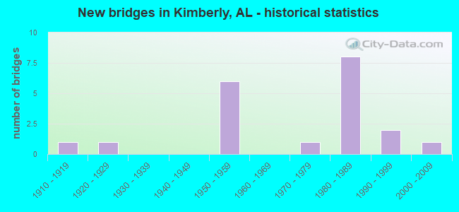
- New bridges - historical statistics
- 11910-1919
- 11920-1929
- 61950-1959
- 11970-1979
- 81980-1989
- 21990-1999
- 12000-2009


- Bridge Condition - Deck
- 9.1%Very good
- 9.1%Good
- 45.5%Satisfactory
- 36.4%Fair

- Bridge Condition - Superstructure
- 9.1%Good
- 81.8%Satisfactory
- 9.1%Fair

- Bridge Condition - Substructure
- 81.8%Satisfactory
- 18.2%Fair

- Bridge Condition - Channel
- 10.0%Good
- 80.0%Satisfactory
- 10.0%Fair

- Bridge Condition - Culverts
- 20.0%Good
- 80.0%Satisfactory
Find on map >> Show street view
Structure Number: 6149, Location: US 31 * L*N RR (Lat: 33.769444, Lng: -86.812778), Route carried "on" structure: US 31, Year Built: 1958, Status: Open, Structure Length: 3.11m (10.20ft), Average Daily Traffic: 4,640 (year 2021), Truck Traffic: 5%, Average Future Daily Traffic: 5,960 (year 2041), Design Load: HS 20, Features Intersected: L*N RR(ABANDONED)
Minimum Vertical Clearance: 30+ m (98+ ft), Kilometerpoint: 471.699, Lanes on structure: 2, Owner: State Highway Agency, Approaching Roadway Width: 8.5m (27.9ft), Skew: 2 degrees, Material/Design: Concrete, Design/Construction: Tee Beam, Number Of Spans In Main Unit: 3, Length of Maximum Span: 10.4m (34.1ft), Curb-To-Curb Width: 8.5m (27.9ft), Out-to-Out Width: 10.1m (33.1ft)
Condition: Deck: Fair, Superstructure: Fair, Substructure: Fair, Operating Rating: 45.6 metric tons, Method Used To Determine Operating Rating: Load Factor (LF), Inventory Rating: 27.4 metric tons, Method Used To Determine Inventory Rating: Load Factor (LF), Structural Evaluation: Somewhat better than minimum adequacy, Deck Geometry: High priority of corrective action, Underclear: High priority of corrective action, Approach Roadway Alignment: Equal to present desirable criteria, Length Of Structure Improvement: 3.96m (12.99ft), Designated Inspection Frequency: Every 24 months, Inspection Date: March 2021, Bridge Improvement Cost: $896,000, Roadway Improvement Cost: $90,000, Total Project Cost: $986,000 ( Estimate for 2022), Deck Structure Type: Concrete Cast-file-Place, Wearing Surface/Protective System: Wearing Surface: Bituminous
Find on map >> Show street view
Structure Number: 615, Location: US 31 * L*N RR (Lat: 33.768333, Lng: -86.813333), Route carried "on" structure: US 31, Year Built: 1958, Status: Open, Structure Length: 3.11m (10.20ft), Average Daily Traffic: 4,640 (year 2021), Truck Traffic: 5%, Average Future Daily Traffic: 5,960 (year 2041), Design Load: HS 20, Features Intersected: L*N RR(ABANDONED)
Minimum Vertical Clearance: 30+ m (98+ ft), Kilometerpoint: 471.699, Lanes on structure: 2, Owner: State Highway Agency, Approaching Roadway Width: 8.5m (27.9ft), Skew: 2 degrees, Material/Design: Concrete, Design/Construction: Tee Beam, Number Of Spans In Main Unit: 3, Length of Maximum Span: 10.4m (34.1ft), Curb-To-Curb Width: 8.5m (27.9ft), Out-to-Out Width: 10.1m (33.1ft)
Condition: Deck: Fair, Superstructure: Satisfactory, Substructure: Fair, Operating Rating: 45.6 metric tons, Method Used To Determine Operating Rating: Load Factor (LF), Inventory Rating: 27.4 metric tons, Method Used To Determine Inventory Rating: Load Factor (LF), Structural Evaluation: Somewhat better than minimum adequacy, Deck Geometry: High priority of corrective action, Approach Roadway Alignment: Better than present minimum criteria, Length Of Structure Improvement: 3.96m (12.99ft), Designated Inspection Frequency: Every 24 months, Inspection Date: March 2021, Bridge Improvement Cost: $896,000, Roadway Improvement Cost: $90,000, Total Project Cost: $986,000 ( Estimate for 2022), Deck Structure Type: Concrete Cast-file-Place, Wearing Surface/Protective System: Wearing Surface: Bituminous
Find on map >> Show street view
Structure Number: 6151, Location: US 31 @ KIMBERLY (Lat: 33.771667, Lng: -86.813056), Route carried "on" structure: US 31, Year Built: 1958, Status: Open, Structure Length: 3.29m (10.79ft), Average Daily Traffic: 4,640 (year 2021), Truck Traffic: 5%, Average Future Daily Traffic: 5,960 (year 2041), Design Load: HS 20, Features Intersected: PROPOSED CITY STREET
Minimum Vertical Clearance: 30+ m (98+ ft), Kilometerpoint: 471.913, Lanes on structure: 2, Owner: State Highway Agency, Approaching Roadway Width: 8.5m (27.9ft), Material/Design: Concrete, Design/Construction: Tee Beam, Number Of Spans In Main Unit: 3, Length of Maximum Span: 11.0m (36.1ft), Curb-To-Curb Width: 8.5m (27.9ft), Out-to-Out Width: 10.1m (33.1ft)
Condition: Deck: Fair, Superstructure: Satisfactory, Substructure: Satisfactory, Operating Rating: 45.8 metric tons, Method Used To Determine Operating Rating: Load Factor (LF), Inventory Rating: 27.5 metric tons, Method Used To Determine Inventory Rating: Load Factor (LF), Structural Evaluation: Equal to present minimum criteria, Deck Geometry: High priority of corrective action, Approach Roadway Alignment: Equal to present desirable criteria, Length Of Structure Improvement: 4.17m (13.68ft), Designated Inspection Frequency: Every 24 months, Inspection Date: March 2021, Bridge Improvement Cost: $943,000, Roadway Improvement Cost: $94,000, Total Project Cost: $1,037,000 ( Estimate for 2022), Deck Structure Type: Concrete Cast-file-Place, Wearing Surface/Protective System: Wearing Surface: Bituminous
Find on map >> Show street view
Structure Number: 6152, Location: US 31 @ KIMBERLY (Lat: 33.771667, Lng: -86.813056), Route carried "on" structure: US 31, Year Built: 1958, Status: Open, Structure Length: 3.29m (10.79ft), Average Daily Traffic: 4,640 (year 2021), Truck Traffic: 5%, Average Future Daily Traffic: 5,960 (year 2041), Design Load: HS 20, Features Intersected: PROPROSED CITY STREET
Minimum Vertical Clearance: 30+ m (98+ ft), Kilometerpoint: 471.913, Lanes on structure: 2, Owner: State Highway Agency, Approaching Roadway Width: 8.5m (27.9ft), Material/Design: Concrete, Design/Construction: Tee Beam, Number Of Spans In Main Unit: 3, Length of Maximum Span: 11.0m (36.1ft), Curb-To-Curb Width: 8.5m (27.9ft), Out-to-Out Width: 10.1m (33.1ft)
Condition: Deck: Fair, Superstructure: Satisfactory, Substructure: Satisfactory, Operating Rating: 45.8 metric tons, Method Used To Determine Operating Rating: Load Factor (LF), Inventory Rating: 27.5 metric tons, Method Used To Determine Inventory Rating: Load Factor (LF), Structural Evaluation: Equal to present minimum criteria, Deck Geometry: High priority of corrective action, Approach Roadway Alignment: Equal to present desirable criteria, Length Of Structure Improvement: 4.17m (13.68ft), Designated Inspection Frequency: Every 24 months, Inspection Date: March 2021, Bridge Improvement Cost: $943,000, Roadway Improvement Cost: $94,000, Total Project Cost: $1,037,000 ( Estimate for 2022), Deck Structure Type: Concrete Cast-file-Place, Wearing Surface/Protective System: Wearing Surface: Bituminous
Find on map >> Show street view
Structure Number: 6547, Location: 4 MI S BLOUNT CO LN (Lat: 33.781300, Lng: -86.819900), Route carried "on" structure: US 31, Year Built: 1959, Status: Open, Structure Length: 22.46m (73.69ft), Average Daily Traffic: 4,315 (year 2021), Truck Traffic: 5%, Average Future Daily Traffic: 5,543 (year 2041), Design Load: HS 20, Features Intersected: LOCUST FK WARRIOR RV
Minimum Vertical Clearance: 30+ m (98+ ft), Kilometerpoint: 473.205, Lanes on structure: 2, Owner: State Highway Agency, Approaching Roadway Width: 12.2m (40.0ft), Material/Design: Steel continuous, Design/Construction: Girder and Floorbeam System, Number Of Spans In Main Unit: 3, Number Of Approach Spans: 5, Length of Maximum Span: 54.9m (180.1ft), Curb-To-Curb Width: 8.5m (27.9ft), Out-to-Out Width: 10.1m (33.1ft)
Condition: Deck: Very good, Superstructure: Satisfactory, Substructure: Satisfactory, Channel: Satisfactory, Operating Rating: 42.6 metric tons, Method Used To Determine Operating Rating: Load Factor (LF), Inventory Rating: 25.6 metric tons, Method Used To Determine Inventory Rating: Load Factor (LF), Structural Evaluation: Equal to present minimum criteria, Deck Geometry: High priority of corrective action, Waterway Adequacy: Superior to present desirable criteria, Approach Roadway Alignment: Equal to present desirable criteria, Length Of Structure Improvement: 22.46m (73.69ft), Designated Inspection Frequency: Every 24 months, Critical Feature Inspection Frequency: Every 24 months, Inspection Date: June 2021, Critical Feature Inspection Date: June 2021, Bridge Improvement Cost: $5,082,000, Roadway Improvement Cost: $508,000, Total Project Cost: $5,590,000 ( Estimate for 2022), Deck Structure Type: Concrete Cast-file-Place, Wearing Surface/Protective System: Wearing Surface: Monolithic Concrete
Find on map >> Show street view
Structure Number: 13075, Location: 2.25 MILES NE OF MAJESTIC (Lat: 33.769247, Lng: -86.740264), Route carried "on" structure: County highway 137, Year Built: 1983, Status: Open, Structure Length: 1.76m (5.77ft), Average Daily Traffic: 276 (year 2019), Truck Traffic: 1%, Average Future Daily Traffic: 320 (year 2039), Design Load: HS 20, Features Intersected: SELF CREEK, Facility Carried by Structure: BRASHER ROAD
Minimum Vertical Clearance: 30+ m (98+ ft), Kilometerpoint: 0.010, Lanes on structure: 2, Owner: County Highway Agency, Approaching Roadway Width: 7.0m (23.0ft), Skew: 3 degrees, Material/Design: Concrete continuous, Design/Construction: Culvert, Number Of Spans In Main Unit: 4, Length of Maximum Span: 4.3m (14.1ft)
Condition: Channel: Satisfactory, Culverts: Satisfactory, Operating Rating: 88.9 metric tons, Method Used To Determine Operating Rating: Load Factor (LF), Inventory Rating: 88.9 metric tons, Method Used To Determine Inventory Rating: Load Factor (LF), Structural Evaluation: Equal to present minimum criteria, Waterway Adequacy: Better than present minimum criteria, Approach Roadway Alignment: Better than present minimum criteria, Length Of Structure Improvement: 2.46m (8.07ft), Designated Inspection Frequency: Every 24 months, Inspection Date: August 2021, Bridge Improvement Cost: $1,052,000, Roadway Improvement Cost: $105,000, Total Project Cost: $1,157,000 ( Estimate for 2022)
Find on map >> Show street view
Structure Number: 13532, Location: I65 * SARDIS RD (Lat: 33.759072, Lng: -86.830428), Route carried "on" structure: Interstate 65, Year Built: 1985, Year Reconstructed: 2003, Status: Open, Structure Length: 5.30m (17.39ft), Average Daily Traffic: 25,220 (year 2020), Truck Traffic: 22%, Average Future Daily Traffic: 31,952 (year 2040), Design Load: HS 20, Features Intersected: SARDIS RD
Minimum Vertical Clearance: 30+ m (98+ ft), Kilometerpoint: 447.430, Lanes on structure: 3, Lanes under structure: 2, Base Highway Network: Yes, Owner: State Highway Agency, Approaching Roadway Width: 17.1m (56.1ft), Skew: 1 degrees, Material/Design: Prestressed concrete, Design/Construction: Stringer/Multi-beam, Number Of Spans In Main Unit: 3, Length of Maximum Span: 21.3m (69.9ft), Curb-To-Curb Width: 17.1m (56.1ft), Out-to-Out Width: 17.9m (58.7ft)
Condition: Deck: Satisfactory, Superstructure: Satisfactory, Substructure: Satisfactory, Operating Rating: 38.8 metric tons, Method Used To Determine Operating Rating: Load Factor (LF), Inventory Rating: 20.3 metric tons, Method Used To Determine Inventory Rating: Load Factor (LF), Structural Evaluation: Somewhat better than minimum adequacy, Deck Geometry: Equal to present minimum criteria, Underclear: Superior to present desirable criteria, Approach Roadway Alignment: Equal to present desirable criteria, Length Of Structure Improvement: 6.33m (20.77ft), Designated Inspection Frequency: Every 24 months, Inspection Date: May 2020, Bridge Improvement Cost: $2,518,000, Roadway Improvement Cost: $252,000, Total Project Cost: $2,770,000 ( Estimate for 2022), Deck Structure Type: Concrete Cast-file-Place
Find on map >> Show street view
Structure Number: 13533, Location: I 65 * SARDIS ROAD (Lat: 33.759047, Lng: -86.830172), Route carried "on" structure: Interstate 65, Year Built: 1985, Year Reconstructed: 2003, Status: Open, Structure Length: 5.30m (17.39ft), Average Daily Traffic: 25,220 (year 2020), Truck Traffic: 22%, Average Future Daily Traffic: 31,952 (year 2040), Design Load: HS 20, Features Intersected: SARDIS ROAD
Minimum Vertical Clearance: 30+ m (98+ ft), Kilometerpoint: 447.430, Lanes on structure: 3, Lanes under structure: 2, Base Highway Network: Yes, Owner: State Highway Agency, Approaching Roadway Width: 17.1m (56.1ft), Skew: 1 degrees, Material/Design: Prestressed concrete, Design/Construction: Stringer/Multi-beam, Number Of Spans In Main Unit: 3, Length of Maximum Span: 21.3m (69.9ft), Curb-To-Curb Width: 17.1m (56.1ft), Out-to-Out Width: 17.3m (56.8ft)
Condition: Deck: Satisfactory, Superstructure: Satisfactory, Substructure: Satisfactory, Operating Rating: 38.8 metric tons, Method Used To Determine Operating Rating: Load Factor (LF), Inventory Rating: 20.3 metric tons, Method Used To Determine Inventory Rating: Load Factor (LF), Structural Evaluation: Somewhat better than minimum adequacy, Deck Geometry: Equal to present minimum criteria, Underclear: Superior to present desirable criteria, Approach Roadway Alignment: Equal to present desirable criteria, Length Of Structure Improvement: 6.33m (20.77ft), Designated Inspection Frequency: Every 24 months, Inspection Date: May 2020, Bridge Improvement Cost: $2,431,000, Roadway Improvement Cost: $243,000, Total Project Cost: $2,674,000 ( Estimate for 2022), Deck Structure Type: Concrete Cast-file-Place
Find on map >> Show street view
Structure Number: 13534, Location: I 65 * LOCUST FK (Lat: 33.769075, Lng: -86.829681), Route carried "on" structure: Interstate 65, Year Built: 1985, Year Reconstructed: 2003, Status: Open, Structure Length: 23.06m (75.66ft), Average Daily Traffic: 25,220 (year 2021), Truck Traffic: 22%, Average Future Daily Traffic: 31,952 (year 2041), Design Load: HS 20, Features Intersected: LOCUST FK WARRIOR RIVER
Minimum Vertical Clearance: 30+ m (98+ ft), Kilometerpoint: 448.502, Lanes on structure: 3, Base Highway Network: Yes, Owner: State Highway Agency, Approaching Roadway Width: 17.1m (56.1ft), Material/Design: Steel continuous, Design/Construction: Stringer/Multi-beam, Number Of Spans In Main Unit: 3, Number Of Approach Spans: 4, Length of Maximum Span: 45.7m (149.9ft), Curb-To-Curb Width: 17.1m (56.1ft), Out-to-Out Width: 17.9m (58.7ft)
Condition: Deck: Satisfactory, Superstructure: Satisfactory, Substructure: Satisfactory, Channel: Satisfactory, Operating Rating: 48.3 metric tons, Method Used To Determine Operating Rating: Load Factor (LF), Inventory Rating: 25.7 metric tons, Method Used To Determine Inventory Rating: Load Factor (LF), Structural Evaluation: Equal to present minimum criteria, Deck Geometry: Equal to present minimum criteria, Waterway Adequacy: Superior to present desirable criteria, Approach Roadway Alignment: Equal to present desirable criteria, Length Of Structure Improvement: 23.06m (75.66ft), Designated Inspection Frequency: Every 24 months, Inspection Date: Febuary 2021, Bridge Improvement Cost: $9,172,000, Roadway Improvement Cost: $917,000, Total Project Cost: $10,089,000 ( Estimate for 2022), Deck Structure Type: Concrete Cast-file-Place
Find on map >> Show street view
Structure Number: 13535, Location: I65 * LOCUST FK (Lat: 33.769019, Lng: -86.829458), Route carried "on" structure: Interstate 65, Year Built: 1985, Year Reconstructed: 2003, Status: Open, Structure Length: 23.06m (75.66ft), Average Daily Traffic: 25,220 (year 2021), Truck Traffic: 22%, Average Future Daily Traffic: 31,952 (year 2041), Design Load: HS 20, Features Intersected: LOCUST FK WARRIOR RIVER
Minimum Vertical Clearance: 30+ m (98+ ft), Kilometerpoint: 448.502, Lanes on structure: 3, Base Highway Network: Yes, Owner: State Highway Agency, Approaching Roadway Width: 17.1m (56.1ft), Material/Design: Steel continuous, Design/Construction: Stringer/Multi-beam, Number Of Spans In Main Unit: 3, Number Of Approach Spans: 4, Length of Maximum Span: 45.7m (149.9ft), Curb-To-Curb Width: 17.1m (56.1ft), Out-to-Out Width: 17.9m (58.7ft)
Condition: Deck: Satisfactory, Superstructure: Satisfactory, Substructure: Satisfactory, Channel: Satisfactory, Operating Rating: 48.3 metric tons, Method Used To Determine Operating Rating: Load Factor (LF), Inventory Rating: 25.7 metric tons, Method Used To Determine Inventory Rating: Load Factor (LF), Structural Evaluation: Equal to present minimum criteria, Deck Geometry: Equal to present minimum criteria, Waterway Adequacy: Equal to present desirable criteria, Approach Roadway Alignment: Equal to present desirable criteria, Length Of Structure Improvement: 23.06m (75.66ft), Designated Inspection Frequency: Every 24 months, Inspection Date: Febuary 2021, Bridge Improvement Cost: $9,172,000, Roadway Improvement Cost: $917,000, Total Project Cost: $10,089,000 ( Estimate for 2022), Deck Structure Type: Concrete Cast-file-Place
Find on map >> Show street view
Structure Number: 1428, Location: SELF CREEK RD @ SELF CREK (Lat: 33.784067, Lng: -86.751414), Route carried "on" structure: County highway 152, Year Built: 1987, Status: Open, Structure Length: 0.68m (2.23ft), Average Daily Traffic: 255 (year 2020), Truck Traffic: 1%, Average Future Daily Traffic: 350 (year 2040), Design Load: HS 20, Features Intersected: SELF CREEK, Facility Carried by Structure: SELF CREEK ROAD
Minimum Vertical Clearance: 30+ m (98+ ft), Kilometerpoint: 0.010, Lanes on structure: 2, Owner: County Highway Agency, Approaching Roadway Width: 6.4m (21.0ft), Skew: 2 degrees, Material/Design: Concrete, Design/Construction: Culvert, Number Of Spans In Main Unit: 2, Length of Maximum Span: 3.0m (9.8ft)
Condition: Channel: Satisfactory, Culverts: Satisfactory, Operating Rating: 62.4 metric tons, Method Used To Determine Operating Rating: Load Factor (LF), Inventory Rating: 37.5 metric tons, Method Used To Determine Inventory Rating: Load Factor (LF), Structural Evaluation: Equal to present minimum criteria, Waterway Adequacy: Equal to present minimum criteria, Approach Roadway Alignment: Better than present minimum criteria, Length Of Structure Improvement: 1.31m (4.30ft), Designated Inspection Frequency: Every 24 months, Inspection Date: July 2020, Bridge Improvement Cost: $689,000, Roadway Improvement Cost: $69,000, Total Project Cost: $758,000 ( Estimate for 2022)
Find on map >> Show street view
Structure Number: 15277, Location: 0.75 MILE W OF CROSSTON (Lat: 33.729350, Lng: -86.739950), Route carried "on" structure: County highway 656, Year Built: 1991, Status: Open, Structure Length: 3.94m (12.93ft), Average Daily Traffic: 3,820 (year 2021), Truck Traffic: 10%, Average Future Daily Traffic: 5,255 (year 2041), Design Load: HS 20, Features Intersected: TURKEY CREEK, Facility Carried by Structure: MAJESTIC ROAD
Minimum Vertical Clearance: 30+ m (98+ ft), Kilometerpoint: 0.000, Lanes on structure: 2, Owner: County Highway Agency, Approaching Roadway Width: 8.8m (28.9ft), Material/Design: Prestressed concrete, Design/Construction: Box Beam or Girders - Multiple, Number Of Spans In Main Unit: 1, Number Of Approach Spans: 2, Length of Maximum Span: 18.3m (60.0ft), Curb or Sidewalk Widths: Left: 0.1m (0.3ft), Right: 0.1m (0.3ft), Curb-To-Curb Width: 9.9m (32.5ft), Out-to-Out Width: 10.1m (33.1ft)
Condition: Deck: Good, Superstructure: Good, Substructure: Satisfactory, Channel: Good, Operating Rating: 57.2 metric tons, Method Used To Determine Operating Rating: Load Factor (LF), Inventory Rating: 41.5 metric tons, Method Used To Determine Inventory Rating: Load Factor (LF), Structural Evaluation: Equal to present minimum criteria, Deck Geometry: Meets minimum limits, Waterway Adequacy: Better than present minimum criteria, Approach Roadway Alignment: Better than present minimum criteria, Length Of Structure Improvement: 4.89m (16.04ft), Designated Inspection Frequency: Every 24 months, Inspection Date: Febuary 2021, Bridge Improvement Cost: $1,107,000, Roadway Improvement Cost: $111,000, Total Project Cost: $1,218,000 ( Estimate for 2022), Deck Structure Type: Concrete Precast Panels, Wearing Surface/Protective System: Wearing Surface: Bituminous
Find on map >> Show street view
Structure Number: 15798, Location: 1/2 MI NE HWY 31 N (Lat: 33.777489, Lng: -86.809039), Route carried "on" structure: County highway 636, Year Built: 1970, Status: Open, Structure Length: 1.07m (3.51ft), Average Daily Traffic: 2,625 (year 2018), Truck Traffic: 5%, Average Future Daily Traffic: 3,137 (year 2038), Design Load: H 15, Features Intersected: LICK CREEK, Facility Carried by Structure: OLD WARRIOR-KIMBER
Minimum Vertical Clearance: 30+ m (98+ ft), Kilometerpoint: 0.000, Lanes on structure: 2, Owner: County Highway Agency, Approaching Roadway Width: 6.4m (21.0ft), Material/Design: Steel, Design/Construction: Culvert, Number Of Spans In Main Unit: 2, Length of Maximum Span: 4.6m (15.1ft)
Condition: Channel: Fair, Culverts: Satisfactory, Operating Rating: 88.9 metric tons, Method Used To Determine Operating Rating: Load Factor (LF), Inventory Rating: 88.9 metric tons, Method Used To Determine Inventory Rating: Load Factor (LF), Structural Evaluation: Equal to present minimum criteria, Waterway Adequacy: Better than present minimum criteria, Approach Roadway Alignment: Better than present minimum criteria, Length Of Structure Improvement: 1.74m (5.71ft), Designated Inspection Frequency: Every 24 months, Inspection Date: November 2020, Bridge Improvement Cost: $1,681,000, Roadway Improvement Cost: $168,000, Total Project Cost: $1,849,000 ( Estimate for 2022)
Find on map >> Show street view
Structure Number: 16677, Location: 2.25 MI NW NEWCASTLE RD (Lat: 33.748650, Lng: -86.760250), Route carried "on" structure: County highway 638, Year Built: 1950, Status: Open, Structure Length: 1.33m (4.36ft), Average Daily Traffic: 4,173 (year 2021), Truck Traffic: 5%, Average Future Daily Traffic: 5,600 (year 2041), Design Load: HS 20, Features Intersected: TURKEY CREEK TRIBUTARY, Facility Carried by Structure: MORRIS-MAJESTIC RD
Minimum Vertical Clearance: 30+ m (98+ ft), Kilometerpoint: 0.000, Lanes on structure: 2, Owner: County Highway Agency, Approaching Roadway Width: 6.4m (21.0ft), Skew: 4 degrees, Material/Design: Concrete continuous, Design/Construction: Culvert, Number Of Spans In Main Unit: 3, Length of Maximum Span: 4.3m (14.1ft)
Condition: Channel: Satisfactory, Culverts: Good, Operating Rating: 62.5 metric tons, Method Used To Determine Operating Rating: Load Factor (LF), Inventory Rating: 37.5 metric tons, Method Used To Determine Inventory Rating: Load Factor (LF), Structural Evaluation: Better than present minimum criteria, Waterway Adequacy: Equal to present minimum criteria, Approach Roadway Alignment: Better than present minimum criteria, Length Of Structure Improvement: 2.01m (6.59ft), Designated Inspection Frequency: Every 24 months, Inspection Date: Febuary 2021, Bridge Improvement Cost: $637,000, Roadway Improvement Cost: $64,000, Total Project Cost: $701,000 ( Estimate for 2022)
Find on map >> Show street view
Structure Number: 16792, Location: 1.1MI NW NEJ PARK (Lat: 33.757706, Lng: -86.724483), Route carried "on" structure: County highway 685, Year Built: 1996, Status: Open, Structure Length: 0.69m (2.26ft), Average Daily Traffic: 110 (year 2020), Truck Traffic: 1%, Average Future Daily Traffic: 150 (year 2040), Design Load: HS 20, Features Intersected: SELF CREEK TRIBUTARY, Facility Carried by Structure: BRASHER ROAD
Minimum Vertical Clearance: 30+ m (98+ ft), Kilometerpoint: 1.759, Lanes on structure: 2, Owner: County Highway Agency, Approaching Roadway Width: 6.5m (21.3ft), Material/Design: Concrete, Design/Construction: Culvert, Number Of Spans In Main Unit: 2, Length of Maximum Span: 3.0m (9.8ft), Curb or Sidewalk Widths: Left: 0.0m, Right: 0.1m (0.3ft), Curb-To-Curb Width: 10.5m (34.4ft), Out-to-Out Width: 11.1m (36.4ft)
Condition: Channel: Satisfactory, Culverts: Satisfactory, Operating Rating: 60.4 metric tons, Method Used To Determine Operating Rating: Load Factor (LF), Inventory Rating: 34.6 metric tons, Method Used To Determine Inventory Rating: Load Factor (LF), Structural Evaluation: Equal to present minimum criteria, Deck Geometry: Better than present minimum criteria, Waterway Adequacy: Equal to present minimum criteria, Approach Roadway Alignment: Better than present minimum criteria, Length Of Structure Improvement: 1.32m (4.33ft), Designated Inspection Frequency: Every 24 months, Inspection Date: October 2020, Bridge Improvement Cost: $274,000, Roadway Improvement Cost: $27,000, Total Project Cost: $301,000 ( Estimate for 2022)
Find on map >> Show street view
Structure Number: 17148, Location: 4 MI.S BLOUNT CO. LN. (Lat: 33.781783, Lng: -86.820006), Route carried "on" structure: US 31, Year Built: 2002, Status: Open, Structure Length: 20.59m (67.55ft), Average Daily Traffic: 4,315 (year 2020), Truck Traffic: 5%, Average Future Daily Traffic: 5,543 (year 2040), Design Load: HS 20, Features Intersected: LOCUST FK WARRIOR RIVER, Facility Carried by Structure: AL - 3 NORTH
Minimum Vertical Clearance: 30.18m (99.02ft), Kilometerpoint: 473.221, Lanes on structure: 2, Owner: State Highway Agency, Approaching Roadway Width: 12.0m (39.4ft), Skew: 1 degrees, Material/Design: Prestressed concrete, Design/Construction: Stringer/Multi-beam, Number Of Spans In Main Unit: 5, Length of Maximum Span: 41.0m (134.5ft), Curb-To-Curb Width: 12.0m (39.4ft), Out-to-Out Width: 12.9m (42.3ft)
Condition: Deck: Satisfactory, Superstructure: Satisfactory, Substructure: Satisfactory, Channel: Satisfactory, Operating Rating: 88.9 metric tons, Method Used To Determine Operating Rating: Load Factor (LF), Inventory Rating: 36.5 metric tons, Method Used To Determine Inventory Rating: Load Factor (LF), Structural Evaluation: Equal to present minimum criteria, Deck Geometry: Better than present minimum criteria, Waterway Adequacy: Equal to present desirable criteria, Approach Roadway Alignment: Equal to present desirable criteria, Length Of Structure Improvement: 20.59m (67.55ft), Designated Inspection Frequency: Every 24 months, Inspection Date: September 2020, Bridge Improvement Cost: $5,930,000, Roadway Improvement Cost: $593,000, Total Project Cost: $6,523,000 ( Estimate for 2022), Deck Structure Type: Concrete Cast-file-Place
Find on map >> Show street view
Structure Number: 123, Location: EAST OF SELF CREEK (Lat: 33.785000, Lng: -86.750000), Route carried "under" structure: County highway 152, Year Built: 1919, Structure Length: 0. m, Average Daily Traffic: 207 (year 1981), Truck Traffic: 1%, Features Intersected: COUNTY ROAD, Facility Carried by Structure: L*N RAILROAD
Minimum Vertical Clearance: 3.51m (11.52ft), Kilometerpoint: 0.010, Lanes under structure: 1, Material/Design: Concrete continuous, Design/Construction: Arch - Deck, Length of Maximum Span: 28.7m (94.2ft)
Find on map >> Show street view
Structure Number: 169, Location: 0.5 MILE NE OF MAJESTIC (Lat: 33.758333, Lng: -86.753333), Route carried "under" structure: County highway 664, Year Built: 1920, Structure Length: 0. m, Average Daily Traffic: 63 (year 1981), Features Intersected: COUNTY ROAD, Facility Carried by Structure: L*N RAILROAD
Minimum Vertical Clearance: 30+ m (98+ ft), Kilometerpoint: 0.010, Lanes under structure: 1, Material/Design: Concrete, Design/Construction: Arch - Deck, Length of Maximum Span: 16.5m (54.1ft)
Find on map >> Show street view
Structure Number: 13532, Location: I65 * SARDIS RD (Lat: 33.759072, Lng: -86.830428), Route carried "under" structure: County highway , Year Built: 1985, Structure Length: 0. m, Average Daily Traffic: 450 (year 2000), Truck Traffic: 20%, Features Intersected: SARDIS RD, Facility Carried by Structure: I - 65 SOUTH
Minimum Vertical Clearance: 0.00m, Kilometerpoint: 0.000, Lanes on structure: 3, Lanes under structure: 2, Material/Design: Prestressed concrete, Design/Construction: Stringer/Multi-beam, Length of Maximum Span: 21.3m (69.9ft)
Find on map >> Show street view
Structure Number: 13533, Location: I 65 * SARDIS ROAD (Lat: 33.759047, Lng: -86.830172), Route carried "under" structure: County highway , Year Built: 1985, Structure Length: 0. m, Average Daily Traffic: 450 (year 2002), Truck Traffic: 20%, Features Intersected: SARDIS ROAD, Facility Carried by Structure: I - 65 NORTH
Minimum Vertical Clearance: 17.07m (56.00ft), Kilometerpoint: 0.000, Lanes on structure: 3, Lanes under structure: 2, Material/Design: Prestressed concrete, Design/Construction: Stringer/Multi-beam, Length of Maximum Span: 21.3m (69.9ft)