Bridge Statistics for Kincaid, West Virginia (WV)
Condition, Traffic, Stress, Structural Evaluation, Project Costs
- National Bridge Inventory (NBI) Statistics
- 18Number of bridges
- 161ft / 49.1mTotal length
- $6,034,000Total costs
- 126,053Total average daily traffic
- 21,110Total average daily truck traffic
- National Bridge Inventory (NBI) Registered Bridges for Kincaid
- No street view available for this location
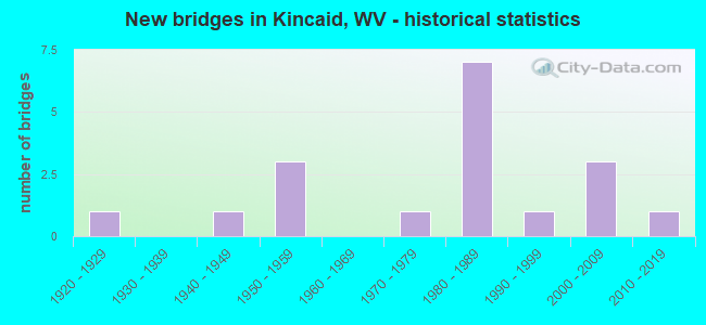
- New bridges - historical statistics
- 11920-1929
- 11940-1949
- 31950-1959
- 11970-1979
- 71980-1989
- 11990-1999
- 32000-2009
- 12010-2019


- Bridge Condition - Deck
- 7.7%Very good
- 23.1%Good
- 38.5%Satisfactory
- 15.4%Fair
- 15.4%Poor

- Bridge Condition - Superstructure
- 14.3%Very good
- 35.7%Good
- 7.1%Satisfactory
- 28.6%Fair
- 14.3%Poor

- Bridge Condition - Substructure
- 7.1%Very good
- 21.4%Good
- 35.7%Satisfactory
- 28.6%Fair
- 7.1%Poor

- Bridge Condition - Channel
- 15.4%Excellent
- 23.1%Very good
- 23.1%Good
- 15.4%Satisfactory
- 15.4%Fair
- 7.7%Poor
Find on map >> Show street view
Structure Number: 10A001, Location: 0.01 Miles N. of CR 1/6 (Lat: 38.033911, Lng: -81.285811), Route carried "on" structure: County highway 100, Year Built: 1988, Status: Open, Structure Length: 0.98m (3.22ft), Average Daily Traffic: 177 (year 2020), Truck Traffic: 6%, Average Future Daily Traffic: 216 (year 2040), Design Load: HS 20, Features Intersected: JOHNSON FORK, Facility Carried by Structure: COUNTY ROUTE 1
Minimum Vertical Clearance: 30+ m (98+ ft), Kilometerpoint: 11.394, Lanes on structure: 2, Owner: State Highway Agency, Approaching Roadway Width: 3.0m (9.8ft), Skew: 2 degrees, Material/Design: Steel, Design/Construction: Stringer/Multi-beam, Number Of Spans In Main Unit: 1, Length of Maximum Span: 8.4m (27.6ft), Curb-To-Curb Width: 6.0m (19.7ft), Out-to-Out Width: 6.1m (20.0ft)
Condition: Deck: Fair, Superstructure: Fair, Substructure: Satisfactory, Channel: Satisfactory, Operating Rating: 69.8 metric tons, Method Used To Determine Operating Rating: Load Factor (LF), Inventory Rating: 42.6 metric tons, Method Used To Determine Inventory Rating: Load Factor (LF), Structural Evaluation: Somewhat better than minimum adequacy, Deck Geometry: High priority of corrective action, Waterway Adequacy: Equal to present desirable criteria, Approach Roadway Alignment: Meets minimum limits, Length Of Structure Improvement: 1.52m (4.99ft), Designated Inspection Frequency: Every 24 months, Inspection Date: June 2021, Bridge Improvement Cost: $286,000, Roadway Improvement Cost: $168,000, Total Project Cost: $454,000 ( Estimate for 2021), Deck Structure Type: Corrugated Steel, Wearing Surface/Protective System: Wearing Surface: Monolithic Concrete, Deck Protection: Galvanized Reinforcing
Find on map >> Show street view
Structure Number: 10A034, Location: 0.01 Miles W. of CR 15/3 (Lat: 37.971531, Lng: -81.256531), Route carried "on" structure: State highway 61200, Year Built: 1950, Status: Posted for load, Structure Length: 0.94m (3.08ft), Average Daily Traffic: 1,958 (year 2019), Truck Traffic: 6%, Average Future Daily Traffic: 2,389 (year 2039), Features Intersected: MOSSY CREEK, Facility Carried by Structure: WV 612
Minimum Vertical Clearance: 30+ m (98+ ft), Kilometerpoint: 3.637, Lanes on structure: 2, Base Highway Network: Yes, Owner: State Highway Agency, Approaching Roadway Width: 8.5m (27.9ft), Skew: 4 degrees, Material/Design: Concrete continuous, Design/Construction: Culvert, Number Of Spans In Main Unit: 2, Length of Maximum Span: 4.3m (14.1ft)
Condition: Channel: Good, Culverts: Fair, Operating Rating: 53.5 metric tons, Method Used To Determine Operating Rating: Field evaluation and documented engineering judgment, Inventory Rating: 24.5 metric tons, Method Used To Determine Inventory Rating: Field evaluation and documented engineering judgment, Structural Evaluation: Somewhat better than minimum adequacy, Waterway Adequacy: Superior to present desirable criteria, Approach Roadway Alignment: Somewhat better than minimum adequacy, Length Of Structure Improvement: 0.94m (3.08ft), Designated Inspection Frequency: Every 24 months, Inspection Date: May 2021, Bridge Improvement Cost: $124,000, Roadway Improvement Cost: $123,000, Total Project Cost: $290,000 ( Estimate for 2021)
Find on map >> Show street view
Structure Number: 10A035, Location: 0.35 Miles W. of CR 15/1 (Lat: 37.975269, Lng: -81.261519), Route carried "on" structure: State highway 61200, Year Built: 1950, Status: Posted for load, Structure Length: 1.00m (3.28ft), Average Daily Traffic: 1,958 (year 2019), Truck Traffic: 6%, Average Future Daily Traffic: 2,389 (year 2039), Features Intersected: MOSSY CREEK, Facility Carried by Structure: WV 612
Minimum Vertical Clearance: 30+ m (98+ ft), Kilometerpoint: 2.977, Lanes on structure: 2, Base Highway Network: Yes, Owner: State Highway Agency, Approaching Roadway Width: 7.3m (24.0ft), Material/Design: Concrete continuous, Design/Construction: Culvert, Number Of Spans In Main Unit: 2, Length of Maximum Span: 4.6m (15.1ft)
Condition: Channel: Poor, Culverts: Fair, Operating Rating: 53.5 metric tons, Method Used To Determine Operating Rating: Field evaluation and documented engineering judgment, Inventory Rating: 24.5 metric tons, Method Used To Determine Inventory Rating: Field evaluation and documented engineering judgment, Structural Evaluation: Somewhat better than minimum adequacy, Waterway Adequacy: Superior to present desirable criteria, Approach Roadway Alignment: Equal to present desirable criteria, Length Of Structure Improvement: 1.65m (5.41ft), Designated Inspection Frequency: Every 24 months, Inspection Date: May 2021, Bridge Improvement Cost: $470,000, Roadway Improvement Cost: $304,000, Total Project Cost: $774,000 ( Estimate for 2021)
Find on map >> Show street view
Structure Number: 10A036, Location: 0.14 Miles E. of CR 23 (Lat: 37.976761, Lng: -81.279489), Route carried "on" structure: State highway 61200, Year Built: 1946, Status: Posted for load, Structure Length: 2.37m (7.78ft), Average Daily Traffic: 1,958 (year 2019), Truck Traffic: 6%, Average Future Daily Traffic: 2,389 (year 2039), Features Intersected: MOSSY CREEK, Facility Carried by Structure: WV 612
Minimum Vertical Clearance: 30+ m (98+ ft), Kilometerpoint: 0.740, Lanes on structure: 2, Base Highway Network: Yes, Owner: State Highway Agency, Approaching Roadway Width: 6.7m (22.0ft), Skew: 1 degrees, Material/Design: Steel, Design/Construction: Stringer/Multi-beam, Number Of Spans In Main Unit: 2, Length of Maximum Span: 11.1m (36.4ft), Curb or Sidewalk Widths: Left: 0.2m (0.7ft), Right: 0.2m (0.7ft), Curb-To-Curb Width: 7.3m (24.0ft), Out-to-Out Width: 8.4m (27.6ft)
Condition: Deck: Fair, Superstructure: Fair, Substructure: Fair, Channel: Satisfactory, Operating Rating: 46.3 metric tons, Method Used To Determine Operating Rating: Load Factor (LF), Inventory Rating: 28.1 metric tons, Method Used To Determine Inventory Rating: Load Factor (LF), Structural Evaluation: Somewhat better than minimum adequacy, Deck Geometry: Meets minimum limits, Waterway Adequacy: Equal to present desirable criteria, Approach Roadway Alignment: Equal to present desirable criteria, Length Of Structure Improvement: 3.11m (10.20ft), Designated Inspection Frequency: Every 24 months, Inspection Date: May 2021, Bridge Improvement Cost: $977,000, Roadway Improvement Cost: $634,000, Total Project Cost: $1,611,000 ( Estimate for 2021), Deck Structure Type: Concrete Cast-file-Place, Wearing Surface/Protective System: Wearing Surface: Bituminous
Find on map >> Show street view
Structure Number: 10A037, Location: 0.01 Miles W. of CR 23 (Lat: 37.976100, Lng: -81.281889), Route carried "on" structure: State highway 61200, Year Built: 1979, Status: Open, Structure Length: 1.74m (5.71ft), Average Daily Traffic: 2,072 (year 2020), Truck Traffic: 6%, Average Future Daily Traffic: 2,528 (year 2040), Design Load: HS 20, Features Intersected: MOSSY CREEK, Facility Carried by Structure: WV 612
Minimum Vertical Clearance: 30+ m (98+ ft), Kilometerpoint: 0.499, Lanes on structure: 2, Base Highway Network: Yes, Owner: State Highway Agency, Approaching Roadway Width: 7.3m (24.0ft), Material/Design: Prestressed concrete, Design/Construction: Box Beam or Girders - Multiple, Number Of Spans In Main Unit: 2, Length of Maximum Span: 8.3m (27.2ft), Curb-To-Curb Width: 9.4m (30.8ft), Out-to-Out Width: 10.1m (33.1ft)
Condition: Deck: Poor, Superstructure: Poor, Substructure: Satisfactory, Channel: Fair, Operating Rating: 60.8 metric tons, Method Used To Determine Operating Rating: Load Factor (LF), Inventory Rating: 38.1 metric tons, Method Used To Determine Inventory Rating: Load Factor (LF), Structural Evaluation: Meets minimum limits, Deck Geometry: Meets minimum limits, Waterway Adequacy: Equal to present desirable criteria, Approach Roadway Alignment: Equal to present desirable criteria, Length Of Structure Improvement: 2.13m (6.99ft), Designated Inspection Frequency: Every 24 months, Inspection Date: May 2021, Bridge Improvement Cost: $432,000, Roadway Improvement Cost: $423,000, Total Project Cost: $1,125,000 ( Estimate for 2021), Deck Structure Type: Other, Wearing Surface/Protective System: Wearing Surface: Bituminous
Find on map >> Show street view
Structure Number: 10A039, Location: 0.31 Miles W. of CR 1 (Lat: 37.980631, Lng: -81.299319), Route carried "on" structure: County highway 1500, Year Built: 1984, Status: Open, Structure Length: 7.32m (24.02ft), Average Daily Traffic: 36 (year 2019), Truck Traffic: 6%, Average Future Daily Traffic: 44 (year 2039), Design Load: HS 20+Mod, Features Intersected: I-77 NBL & SBL, Facility Carried by Structure: COUNTY ROUTE 15
Minimum Vertical Clearance: 30+ m (98+ ft), Kilometerpoint: 16.319, Lanes on structure: 2, Lanes under structure: 4, Owner: State Highway Agency, Approaching Roadway Width: 4.9m (16.1ft), Skew: 5 degrees, Material/Design: Steel, Design/Construction: Stringer/Multi-beam, Number Of Spans In Main Unit: 1, Number Of Approach Spans: 3, Length of Maximum Span: 19.4m (63.6ft), Curb-To-Curb Width: 11.8m (38.7ft), Out-to-Out Width: 12.9m (42.3ft)
Condition: Deck: Satisfactory, Superstructure: Good, Substructure: Fair, Operating Rating: 60.8 metric tons, Method Used To Determine Operating Rating: Load Factor (LF), Inventory Rating: 36.3 metric tons, Method Used To Determine Inventory Rating: Load Factor (LF), Structural Evaluation: Somewhat better than minimum adequacy, Deck Geometry: Superior to present desirable criteria, Underclear: Equal to present minimum criteria, Approach Roadway Alignment: Equal to present minimum criteria, Designated Inspection Frequency: Every 24 months, Inspection Date: April 2020, Deck Structure Type: Concrete Cast-file-Place, Wearing Surface/Protective System: Wearing Surface: Monolithic Concrete, Deck Protection: Epoxy Coated Reinforcing
Find on map >> Show street view
Structure Number: 10A04, Location: 1.07 Miles S. of CR 15/9 (Lat: 37.987261, Lng: -81.306739), Route carried "on" structure: County highway 1500, Year Built: 1984, Status: Open, Structure Length: 4.42m (14.50ft), Average Daily Traffic: 36 (year 2019), Truck Traffic: 6%, Average Future Daily Traffic: 44 (year 2039), Design Load: HS 20, Features Intersected: I-77 NBL & SBL, Facility Carried by Structure: COUNTY ROUTE 15
Minimum Vertical Clearance: 30+ m (98+ ft), Kilometerpoint: 17.928, Lanes on structure: 2, Lanes under structure: 4, Owner: State Highway Agency, Approaching Roadway Width: 8.5m (27.9ft), Skew: 4 degrees, Material/Design: Steel continuous, Design/Construction: Stringer/Multi-beam, Number Of Spans In Main Unit: 1, Number Of Approach Spans: 1, Length of Maximum Span: 22.2m (72.8ft), Curb-To-Curb Width: 11.8m (38.7ft), Out-to-Out Width: 12.9m (42.3ft)
Condition: Deck: Good, Superstructure: Fair, Substructure: Fair, Operating Rating: 66.2 metric tons, Method Used To Determine Operating Rating: Load Factor (LF), Inventory Rating: 39.9 metric tons, Method Used To Determine Inventory Rating: Load Factor (LF), Structural Evaluation: Somewhat better than minimum adequacy, Deck Geometry: Superior to present desirable criteria, Underclear: Somewhat better than minimum adequacy, Approach Roadway Alignment: Better than present minimum criteria, Designated Inspection Frequency: Every 24 months, Inspection Date: April 2020, Deck Structure Type: Concrete Cast-file-Place, Wearing Surface/Protective System: Wearing Surface: Monolithic Concrete, Deck Protection: Epoxy Coated Reinforcing
Find on map >> Show street view
Structure Number: 10A041, Location: 0.52 Miles N. of CR 15/9 (Lat: 37.991300, Lng: -81.326631), Route carried "on" structure: County highway 1500, Year Built: 1925, Status: Posted for load, Structure Length: 1.93m (6.33ft), Average Daily Traffic: 43 (year 2019), Truck Traffic: 6%, Average Future Daily Traffic: 52 (year 2039), Features Intersected: PAINT CREEK, Facility Carried by Structure: COUNTY ROUTE 15
Minimum Vertical Clearance: 30+ m (98+ ft), Kilometerpoint: 20.487, Lanes on structure: 1, Owner: State Highway Agency, Approaching Roadway Width: 4.3m (14.1ft), Material/Design: Concrete, Design/Construction: Arch - Deck, Number Of Spans In Main Unit: 1, Length of Maximum Span: 19.0m (62.3ft), Curb or Sidewalk Widths: Left: 0.2m (0.7ft), Right: 0.2m (0.7ft), Curb-To-Curb Width: 4.6m (15.1ft), Out-to-Out Width: 5.5m (18.0ft)
Condition: Superstructure: Poor, Substructure: Fair, Channel: Fair, Operating Rating: 41.7 metric tons, Method Used To Determine Operating Rating: Field evaluation and documented engineering judgment, Inventory Rating: 16.3 metric tons, Method Used To Determine Inventory Rating: Field evaluation and documented engineering judgment, Structural Evaluation: Meets minimum limits, Deck Geometry: Better than present minimum criteria, Waterway Adequacy: Equal to present desirable criteria, Approach Roadway Alignment: High priority of corrective action, Length Of Structure Improvement: 2.59m (8.50ft), Designated Inspection Frequency: Every 24 months, Other Special Inspection Frequency: Every 12 months, Inspection Date: May 2021, Other Special Inspection Date: May 2021, Bridge Improvement Cost: $344,000, Roadway Improvement Cost: $172,000, Total Project Cost: $516,000 ( Estimate for 2021)
Find on map >> Show street view
Structure Number: 10A055, Location: 0.01 Miles W. of CR 15 (Lat: 37.975200, Lng: -81.283561), Route carried "on" structure: State highway 61200, Year Built: 1954, Status: Posted for load, Structure Length: 3.12m (10.24ft), Average Daily Traffic: 1,900 (year 2020), Truck Traffic: 6%, Average Future Daily Traffic: 2,318 (year 2040), Design Load: H 20, Features Intersected: PAINT CREEK, Facility Carried by Structure: WV 612
Minimum Vertical Clearance: 30+ m (98+ ft), Kilometerpoint: 0.306, Lanes on structure: 2, Base Highway Network: Yes, Owner: State Highway Agency, Approaching Roadway Width: 7.9m (25.9ft), Material/Design: Steel, Design/Construction: Stringer/Multi-beam, Number Of Spans In Main Unit: 1, Number Of Approach Spans: 2, Length of Maximum Span: 15.8m (51.8ft), Curb-To-Curb Width: 9.1m (29.9ft), Out-to-Out Width: 10.6m (34.8ft)
Condition: Deck: Poor, Superstructure: Fair, Substructure: Poor, Channel: Very good, Operating Rating: 65.3 metric tons, Method Used To Determine Operating Rating: Load Factor (LF), Inventory Rating: 39.0 metric tons, Method Used To Determine Inventory Rating: Load Factor (LF), Structural Evaluation: Meets minimum limits, Deck Geometry: Somewhat better than minimum adequacy, Waterway Adequacy: Equal to present desirable criteria, Approach Roadway Alignment: High priority of corrective action, Length Of Structure Improvement: 3.90m (12.80ft), Designated Inspection Frequency: Every 24 months, Inspection Date: September 2021, Bridge Improvement Cost: $779,000, Roadway Improvement Cost: $485,000, Total Project Cost: $1,264,000 ( Estimate for 2021), Deck Structure Type: Concrete Cast-file-Place, Wearing Surface/Protective System: Wearing Surface: Latex Concrete
Find on map >> Show street view
Structure Number: 10A139, Location: 0.01 Miles S. of WV 61 (Lat: 38.017639, Lng: -81.239511), Route carried "on" structure: County highway 6169, Year Built: 1996, Status: Open, Structure Length: 2.25m (7.38ft), Average Daily Traffic: 80 (year 2016), Average Future Daily Traffic: 98 (year 2036), Design Load: HS 25 or greater, Features Intersected: LOOP CREEK, Facility Carried by Structure: COUNTY ROUTE 61/69
Minimum Vertical Clearance: 30+ m (98+ ft), Kilometerpoint: 0.016, Lanes on structure: 2, Owner: State Highway Agency, Approaching Roadway Width: 6.1m (20.0ft), Material/Design: Prestressed concrete, Design/Construction: Box Beam or Girders - Multiple, Number Of Spans In Main Unit: 1, Length of Maximum Span: 21.9m (71.9ft), Curb-To-Curb Width: 6.0m (19.7ft), Out-to-Out Width: 6.5m (21.3ft)
Condition: Deck: Good, Superstructure: Good, Substructure: Good, Channel: Excellent, Operating Rating: 83.4 metric tons, Method Used To Determine Operating Rating: Load Factor (LF), Inventory Rating: 50.8 metric tons, Method Used To Determine Inventory Rating: Load Factor (LF), Structural Evaluation: Better than present minimum criteria, Deck Geometry: Meets minimum limits, Waterway Adequacy: Equal to present desirable criteria, Approach Roadway Alignment: Equal to present minimum criteria, Designated Inspection Frequency: Every 48 months, Inspection Date: August 2019, Deck Structure Type: Other, Wearing Surface/Protective System: Wearing Surface: Bituminous, Deck Protection: Epoxy Coated Reinforcing
Find on map >> Show street view
Structure Number: 10A235, Location: AT CR 15/4 (Lat: 37.973231, Lng: -81.284689), Route carried "on" structure: Interstate 7700, Year Built: 1985, Status: Open, Structure Length: 4.91m (16.11ft), Average Daily Traffic: 25,838 (year 2017), Truck Traffic: 18%, Average Future Daily Traffic: 32,061 (year 2037), Design Load: HS 20+Mod, Features Intersected: WV 612, Facility Carried by Structure: I-77
Minimum Vertical Clearance: 30+ m (98+ ft), Kilometerpoint: 95.901, Lanes on structure: 4, Lanes under structure: 2, Base Highway Network: Yes, Toll: On Interstate toll segment, Owner: State Toll Authority, Approaching Roadway Width: 25.0m (82.0ft), Skew: 31 degrees, Material/Design: Steel continuous, Design/Construction: Stringer/Multi-beam, Number Of Spans In Main Unit: 1, Number Of Approach Spans: 2, Length of Maximum Span: 19.7m (64.6ft), Curb-To-Curb Width: 25.7m (84.3ft), Out-to-Out Width: 27.5m (90.2ft)
Condition: Deck: Satisfactory, Superstructure: Good, Substructure: Satisfactory, Operating Rating: 66.2 metric tons, Method Used To Determine Operating Rating: Load Factor (LF), Inventory Rating: 39.9 metric tons, Method Used To Determine Inventory Rating: Load Factor (LF), Structural Evaluation: Equal to present minimum criteria, Deck Geometry: Superior to present desirable criteria, Underclear: Equal to present minimum criteria, Approach Roadway Alignment: Equal to present desirable criteria, Designated Inspection Frequency: Every 24 months, Inspection Date: November 2020, Deck Structure Type: Concrete Cast-file-Place, Wearing Surface/Protective System: Wearing Surface: Monolithic Concrete, Deck Protection: Epoxy Coated Reinforcing
Find on map >> Show street view
Structure Number: 10A237, Location: 1.57 MI N OF CR 15/4 (Lat: 37.986961, Lng: -81.305589), Route carried "on" structure: Interstate 7700, Year Built: 1985, Status: Open, Structure Length: 10.77m (35.33ft), Average Daily Traffic: 29,547 (year 2018), Truck Traffic: 17%, Average Future Daily Traffic: 36,933 (year 2038), Design Load: HS 20+Mod, Features Intersected: MILBURN CREEK, Facility Carried by Structure: I-77
Minimum Vertical Clearance: 30+ m (98+ ft), Kilometerpoint: 98.492, Lanes on structure: 4, Base Highway Network: Yes, Toll: On Interstate toll segment, Owner: State Toll Authority, Approaching Roadway Width: 25.6m (84.0ft), Skew: 34 degrees, Material/Design: Steel continuous, Design/Construction: Stringer/Multi-beam, Number Of Spans In Main Unit: 1, Number Of Approach Spans: 3, Length of Maximum Span: 29.0m (95.1ft), Curb-To-Curb Width: 25.4m (83.3ft), Out-to-Out Width: 27.5m (90.2ft)
Condition: Deck: Satisfactory, Superstructure: Satisfactory, Substructure: Satisfactory, Channel: Very good, Operating Rating: 61.7 metric tons, Method Used To Determine Operating Rating: Load Factor (LF), Inventory Rating: 37.2 metric tons, Method Used To Determine Inventory Rating: Load Factor (LF), Structural Evaluation: Equal to present minimum criteria, Deck Geometry: Superior to present desirable criteria, Waterway Adequacy: Superior to present desirable criteria, Approach Roadway Alignment: Equal to present desirable criteria, Designated Inspection Frequency: Every 24 months, Other Special Inspection Frequency: Every 12 months, Inspection Date: May 2021, Other Special Inspection Date: May 2021, Deck Structure Type: Concrete Cast-file-Place, Wearing Surface/Protective System: Wearing Surface: Monolithic Concrete, Deck Protection: Epoxy Coated Reinforcing
Find on map >> Show street view
Structure Number: 10A259, Location: 0.01 Miles S. of WV 61 (Lat: 38.020081, Lng: -81.253381), Route carried "on" structure: ServiceOther road 92600, Year Built: 2000, Status: Open, Structure Length: 0.98m (3.22ft), Average Daily Traffic: 33 (year 2020), Truck Traffic: 28%, Average Future Daily Traffic: 40 (year 2040), Features Intersected: LOOP CREEK, Facility Carried by Structure: HARP 926
Minimum Vertical Clearance: 30+ m (98+ ft), Kilometerpoint: 0.016, Lanes on structure: 1, Owner: State Highway Agency, Approaching Roadway Width: 3.7m (12.1ft), Material/Design: Steel, Design/Construction: Stringer/Multi-beam, Number Of Spans In Main Unit: 1, Length of Maximum Span: 9.5m (31.2ft), Curb-To-Curb Width: 4.7m (15.4ft), Out-to-Out Width: 4.9m (16.1ft)
Condition: Deck: Satisfactory, Superstructure: Good, Substructure: Satisfactory, Channel: Good, Operating Rating: 55.3 metric tons, Method Used To Determine Operating Rating: Load Factor (LF), Inventory Rating: 33.6 metric tons, Method Used To Determine Inventory Rating: Load Factor (LF), Structural Evaluation: Equal to present minimum criteria, Deck Geometry: Better than present minimum criteria, Waterway Adequacy: Superior to present desirable criteria, Approach Roadway Alignment: Equal to present minimum criteria, Designated Inspection Frequency: Every 48 months, Inspection Date: June 2021, Deck Structure Type: Wood or Timber, Wearing Surface/Protective System: Wearing Surface: Wood or Timber
Find on map >> Show street view
Structure Number: 10A27, Location: 0.01 Miles S. of WV 61 (Lat: 38.033069, Lng: -81.270439), Route carried "on" structure: County highway 6134, Year Built: 2001, Status: Open, Structure Length: 1.75m (5.74ft), Average Daily Traffic: 10 (year 2016), Average Future Daily Traffic: 12 (year 2036), Design Load: HS 20, Features Intersected: LOOP CREEK, Facility Carried by Structure: COUNTY ROUTE 61/34
Minimum Vertical Clearance: 30+ m (98+ ft), Kilometerpoint: 0.016, Lanes on structure: 1, Owner: State Highway Agency, Approaching Roadway Width: 3.4m (11.2ft), Material/Design: Steel, Design/Construction: Stringer/Multi-beam, Number Of Spans In Main Unit: 1, Length of Maximum Span: 16.6m (54.5ft), Curb-To-Curb Width: 4.5m (14.8ft), Out-to-Out Width: 4.9m (16.1ft)
Condition: Deck: Satisfactory, Superstructure: Good, Substructure: Good, Channel: Good, Operating Rating: 58.0 metric tons, Method Used To Determine Operating Rating: Load Factor (LF), Inventory Rating: 34.5 metric tons, Method Used To Determine Inventory Rating: Load Factor (LF), Structural Evaluation: Better than present minimum criteria, Deck Geometry: Equal to present minimum criteria, Waterway Adequacy: Equal to present desirable criteria, Approach Roadway Alignment: Equal to present minimum criteria, Designated Inspection Frequency: Every 48 months, Inspection Date: July 2019, Deck Structure Type: Wood or Timber, Wearing Surface/Protective System: Deck Protection: Other
Find on map >> Show street view
Structure Number: 10A3, Location: 0.01 Miles N. of CR 1 (Lat: 37.978550, Lng: -81.294611), Route carried "on" structure: County highway 1500, Year Built: 2009, Status: Open, Structure Length: 2.83m (9.28ft), Average Daily Traffic: 219 (year 2020), Truck Traffic: 6%, Average Future Daily Traffic: 267 (year 2040), Design Load: HL 93, Features Intersected: PAINT CREEK, Facility Carried by Structure: COUNTY ROUTE 15
Minimum Vertical Clearance: 30+ m (98+ ft), Kilometerpoint: 15.852, Lanes on structure: 2, Owner: State Highway Agency, Approaching Roadway Width: 5.5m (18.0ft), Material/Design: Steel, Design/Construction: Stringer/Multi-beam, Number Of Spans In Main Unit: 1, Length of Maximum Span: 27.4m (89.9ft), Curb-To-Curb Width: 8.4m (27.6ft), Out-to-Out Width: 9.3m (30.5ft)
Condition: Deck: Good, Superstructure: Very good, Substructure: Good, Channel: Excellent, Operating Rating: 88.9 metric tons, Method Used To Determine Operating Rating: Load and Resistance Factor (LRFR), Inventory Rating: 68.9 metric tons, Method Used To Determine Inventory Rating: Load and Resistance Factor (LRFR), Structural Evaluation: Better than present minimum criteria, Deck Geometry: Somewhat better than minimum adequacy, Waterway Adequacy: Superior to present desirable criteria, Approach Roadway Alignment: Better than present minimum criteria, Designated Inspection Frequency: Every 24 months, Inspection Date: July 2021, Deck Structure Type: Concrete Cast-file-Place, Wearing Surface/Protective System: Wearing Surface: Monolithic Concrete, Deck Protection: Epoxy Coated Reinforcing
Find on map >> Show street view
Structure Number: 10A319, Location: 0.01 Miles S. of WV 61 (Lat: 38.036461, Lng: -81.271011), Route carried "on" structure: County highway 100, Year Built: 2019, Status: Open, Structure Length: 1.82m (5.97ft), Average Daily Traffic: 188 (year 2021), Truck Traffic: 6%, Average Future Daily Traffic: 229 (year 2041), Design Load: HL 93, Features Intersected: Loop Creek, Facility Carried by Structure: County Route 1
Minimum Vertical Clearance: 30+ m (98+ ft), Kilometerpoint: 12.859, Lanes on structure: 1, Owner: State Highway Agency, Approaching Roadway Width: 7.3m (24.0ft), Material/Design: Prestressed concrete, Design/Construction: Box Beam or Girders - Multiple, Number Of Spans In Main Unit: 1, Length of Maximum Span: 0.0m, Curb-To-Curb Width: 6.4m (21.0ft), Out-to-Out Width: 6.4m (21.0ft)
Condition: Deck: Very good, Superstructure: Very good, Substructure: Very good, Channel: Very good, Operating Rating: 62.6 metric tons, Method Used To Determine Operating Rating: Load and Resistance Factor (LRFR), Inventory Rating: 48.1 metric tons, Method Used To Determine Inventory Rating: Load and Resistance Factor (LRFR), Structural Evaluation: Equal to present desirable criteria, Deck Geometry: Meets minimum limits, Waterway Adequacy: Equal to present desirable criteria, Approach Roadway Alignment: Equal to present minimum criteria, Designated Inspection Frequency: Every 48 months, Inspection Date: January 2022, Deck Structure Type: Concrete Precast Panels, Wearing Surface/Protective System: Wearing Surface: Bituminous, Membrane: Preformed Fabric, Deck Protection: Epoxy Coated Reinforcing
Find on map >> Show street view
Structure Number: 10A039, Location: 0.31 Miles W. of CR 1 (Lat: 37.980603, Lng: -81.299244), Route carried "under" structure: Interstate 7700, Year Built: 1984, Structure Length: 0. m, Average Daily Traffic: 30,000 (year 0010), Truck Traffic: 18%, Features Intersected: I-77 NBL & SBL, Facility Carried by Structure: COUNTY ROUTE 15
Minimum Vertical Clearance: 5.46m (17.91ft), Kilometerpoint: 97.575, Lanes on structure: 2, Lanes under structure: 4, Length of Maximum Span: 19.4m (63.6ft)
Find on map >> Show street view
Structure Number: 10A04, Location: 1.07 Miles S. of CR 15/9 (Lat: 37.987267, Lng: -81.306742), Route carried "under" structure: Interstate 7700, Year Built: 1984, Structure Length: 0. m, Average Daily Traffic: 30,000 (year 0010), Truck Traffic: 18%, Features Intersected: I-77 NBL & SBL, Facility Carried by Structure: COUNTY ROUTE 15
Minimum Vertical Clearance: 5.08m (16.67ft), Kilometerpoint: 98.605, Lanes on structure: 2, Lanes under structure: 4, Length of Maximum Span: 22.2m (72.8ft)