Bridge Statistics for King, North Carolina (NC)
Condition, Traffic, Stress, Structural Evaluation, Project Costs
- National Bridge Inventory (NBI) Statistics
- 38Number of bridges
- 246ft / 75.3mTotal length
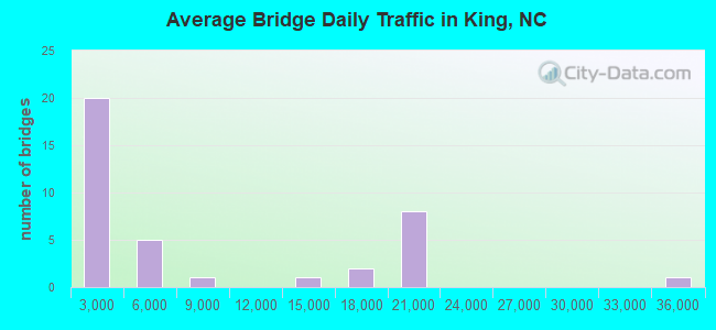
- 272,670Total average daily traffic
- 30,459Total average daily truck traffic
- National Bridge Inventory (NBI) Registered Bridges for King
- No street view available for this location
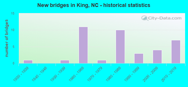
- New bridges - historical statistics
- 11930-1939
- 11950-1959
- 111960-1969
- 11970-1979
- 101980-1989
- 31990-1999
- 42000-2009
- 72010-2019
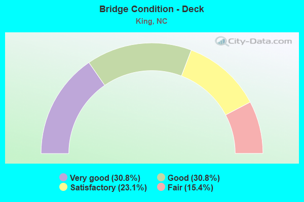
- Bridge Condition - Deck
- 30.8%Very good
- 30.8%Good
- 23.1%Satisfactory
- 15.4%Fair
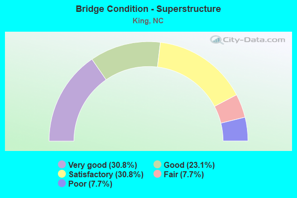
- Bridge Condition - Superstructure
- 30.8%Very good
- 23.1%Good
- 30.8%Satisfactory
- 7.7%Fair
- 7.7%Poor
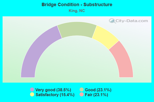
- Bridge Condition - Substructure
- 38.5%Very good
- 23.1%Good
- 15.4%Satisfactory
- 23.1%Fair
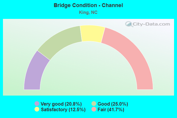
- Bridge Condition - Channel
- 20.8%Very good
- 25.0%Good
- 12.5%Satisfactory
- 41.7%Fair
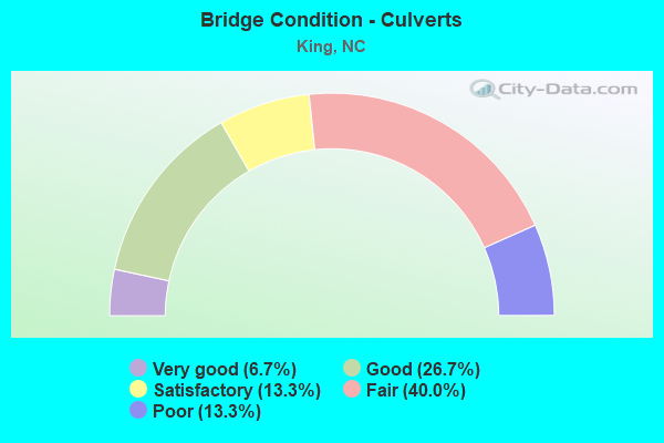
- Bridge Condition - Culverts
- 6.7%Very good
- 26.7%Good
- 13.3%Satisfactory
- 40.0%Fair
- 13.3%Poor
Find on map >> Show street view
Structure Number: 670142, Location: 0.1 MI. W. JCT. SR1893 (Lat: 36.257503, Lng: -80.323681), Route carried "on" structure: State highway 1639, Year Built: 2017, Status: Open, Structure Length: 2.65m (8.69ft), Average Daily Traffic: 1,300 (year 2019), Truck Traffic: 7%, Average Future Daily Traffic: 2,600 (year 2040), Design Load: HL 93, Features Intersected: WEST FORK MUDDY CREEK
Minimum Vertical Clearance: 30+ m (98+ ft), Kilometerpoint: 0.000, Lanes on structure: 2, Owner: State Highway Agency, Approaching Roadway Width: 6.0m (19.7ft), Material/Design: Prestressed concrete, Design/Construction: Box Beam or Girders - Multiple, Number Of Spans In Main Unit: 1, Length of Maximum Span: 25.6m (84.0ft), Curb-To-Curb Width: 8.2m (26.9ft), Out-to-Out Width: 9.1m (29.9ft)
Condition: Deck: Very good, Superstructure: Very good, Substructure: Very good, Channel: Good, Operating Rating: 83.4 metric tons, Method Used To Determine Operating Rating: Load and Resistance Factor (LRFR), Inventory Rating: 60.7 metric tons, Method Used To Determine Inventory Rating: Load and Resistance Factor (LRFR), Structural Evaluation: Equal to present desirable criteria, Deck Geometry: Meets minimum limits, Waterway Adequacy: Equal to present desirable criteria, Approach Roadway Alignment: Equal to present desirable criteria, Designated Inspection Frequency: Every 24 months, Inspection Date: December 2021, Deck Structure Type: Concrete Precast Panels, Wearing Surface/Protective System: Wearing Surface: Bituminous
Find on map >> Show street view
Structure Number: 670283, Location: 0.1 MI. N. JCT. SR1639 (Lat: 36.258311, Lng: -80.323972), Route carried "on" structure: State highway 1893, Year Built: 2017, Status: Open, Structure Length: 2.04m (6.69ft), Average Daily Traffic: 100 (year 2019), Truck Traffic: 7%, Average Future Daily Traffic: 200 (year 2040), Design Load: HL 93, Features Intersected: MUDDY CREEK
Minimum Vertical Clearance: 30+ m (98+ ft), Kilometerpoint: 0.000, Lanes on structure: 2, Owner: State Highway Agency, Approaching Roadway Width: 6.0m (19.7ft), Skew: 1 degrees, Material/Design: Prestressed concrete, Design/Construction: Slab, Number Of Spans In Main Unit: 1, Length of Maximum Span: 20.1m (65.9ft), Curb-To-Curb Width: 7.3m (24.0ft), Out-to-Out Width: 8.2m (26.9ft)
Condition: Deck: Very good, Superstructure: Very good, Substructure: Very good, Channel: Very good, Operating Rating: 54.4 metric tons, Method Used To Determine Operating Rating: Load and Resistance Factor (LRFR), Inventory Rating: 41.7 metric tons, Method Used To Determine Inventory Rating: Load and Resistance Factor (LRFR), Structural Evaluation: Equal to present desirable criteria, Deck Geometry: Equal to present minimum criteria, Waterway Adequacy: Equal to present desirable criteria, Approach Roadway Alignment: Equal to present desirable criteria, Designated Inspection Frequency: Every 24 months, Inspection Date: December 2021, Deck Structure Type: Concrete Precast Panels, Wearing Surface/Protective System: Wearing Surface: Bituminous
Find on map >> Show street view
Structure Number: 670347, Location: 1.8 MI. N. JCT. SR1634 (Lat: 36.260444, Lng: -80.364886), Route carried "on" structure: State highway 1611, Year Built: 2011, Status: Open, Structure Length: 7.28m (23.88ft), Average Daily Traffic: 13,000 (year 2017), Truck Traffic: 6%, Average Future Daily Traffic: 26,000 (year 2040), Design Load: HL 93, Features Intersected: US52
Minimum Vertical Clearance: 30+ m (98+ ft), Kilometerpoint: 0.000, Lanes on structure: 5, Lanes under structure: 4, Owner: State Highway Agency, Approaching Roadway Width: 26.8m (87.9ft), Skew: 22 degrees, Material/Design: Steel continuous, Design/Construction: Stringer/Multi-beam, Number Of Spans In Main Unit: 2, Length of Maximum Span: 35.9m (117.8ft), Curb or Sidewalk Widths: Left: 1.6m (5.2ft), Right: 1.6m (5.2ft), Curb-To-Curb Width: 25.6m (84.0ft), Out-to-Out Width: 29.6m (97.1ft)
Condition: Deck: Good, Superstructure: Very good, Substructure: Very good, Operating Rating: 58.0 metric tons, Method Used To Determine Operating Rating: Load and Resistance Factor (LRFR), Inventory Rating: 43.5 metric tons, Method Used To Determine Inventory Rating: Load and Resistance Factor (LRFR), Structural Evaluation: Equal to present desirable criteria, Deck Geometry: Superior to present desirable criteria, Underclear: Equal to present minimum criteria, Approach Roadway Alignment: Equal to present desirable criteria, Designated Inspection Frequency: Every 24 months, Inspection Date: June 2020, Deck Structure Type: Concrete Cast-file-Place, Wearing Surface/Protective System: Wearing Surface: Monolithic Concrete, Deck Protection: Epoxy Coated Reinforcing
Find on map >> Show street view
Structure Number: 670428, Location: .05 MI.W. JCT.US52N RAMP (Lat: 36.248228, Lng: -80.352742), Route carried "on" structure: State highway 1634, Year Built: 1986, Status: Open, Structure Length: 6.70m (21.98ft), Average Daily Traffic: 5,800 (year 2017), Truck Traffic: 6%, Average Future Daily Traffic: 11,600 (year 2040), Design Load: HS 20+Mod, Features Intersected: US52
Minimum Vertical Clearance: 30+ m (98+ ft), Kilometerpoint: 0.000, Lanes on structure: 3, Lanes under structure: 5, Owner: State Highway Agency, Approaching Roadway Width: 8.5m (27.9ft), Skew: 3 degrees, Material/Design: Prestressed concrete, Design/Construction: Stringer/Multi-beam, Number Of Spans In Main Unit: 4, Length of Maximum Span: 23.7m (77.8ft), Curb-To-Curb Width: 12.8m (42.0ft), Out-to-Out Width: 13.6m (44.6ft)
Condition: Deck: Satisfactory, Superstructure: Fair, Substructure: Satisfactory, Operating Rating: 68.9 metric tons, Method Used To Determine Operating Rating: Load Factor (LF), Inventory Rating: 40.8 metric tons, Method Used To Determine Inventory Rating: Load Factor (LF), Structural Evaluation: Somewhat better than minimum adequacy, Deck Geometry: Meets minimum limits, Underclear: Somewhat better than minimum adequacy, Approach Roadway Alignment: Equal to present desirable criteria, Designated Inspection Frequency: Every 24 months, Inspection Date: June 2020, Deck Structure Type: Concrete Cast-file-Place, Wearing Surface/Protective System: Wearing Surface: Integral Concrete
Find on map >> Show street view
Structure Number: 1690009, Location: 25 FT. S. JCT. SR1168 (Lat: 36.356792, Lng: -80.337631), Route carried "on" structure: State highway 1166, Year Built: 1984, Status: Open, Structure Length: 1.18m (3.87ft), Average Daily Traffic: 500 (year 2015), Truck Traffic: 6%, Average Future Daily Traffic: 1,040 (year 2040), Design Load: HS 20+Mod, Features Intersected: E. PRONG LITTLE YADKIN R
Minimum Vertical Clearance: 30+ m (98+ ft), Kilometerpoint: 0.000, Lanes on structure: 2, Owner: State Highway Agency, Approaching Roadway Width: 5.7m (18.7ft), Skew: 4 degrees, Material/Design: Steel, Design/Construction: Culvert, Number Of Spans In Main Unit: 3, Length of Maximum Span: 2.4m (7.9ft)
Condition: Channel: Satisfactory, Culverts: Satisfactory, Operating Rating: 89.8 metric tons, Method Used To Determine Operating Rating: Load and Resistance Factor (LRFR), Inventory Rating: 89.8 metric tons, Method Used To Determine Inventory Rating: Load and Resistance Factor (LRFR), Structural Evaluation: Equal to present minimum criteria, Waterway Adequacy: Equal to present minimum criteria, Approach Roadway Alignment: Equal to present desirable criteria, Designated Inspection Frequency: Every 24 months, Inspection Date: Febuary 2021
Find on map >> Show street view
Structure Number: 169001, Location: 1.0 MI. E. JCT. SR1222 (Lat: 36.272208, Lng: -80.376622), Route carried "on" structure: State highway 1105, Year Built: 1960, Status: Temporarily open, Structure Length: 8.10m (26.57ft), Average Daily Traffic: 3,000 (year 2015), Truck Traffic: 7%, Average Future Daily Traffic: 6,000 (year 2040), Design Load: H 15, Features Intersected: US52
Minimum Vertical Clearance: 30+ m (98+ ft), Kilometerpoint: 0.000, Lanes on structure: 2, Lanes under structure: 8, Owner: State Highway Agency, Approaching Roadway Width: 7.0m (23.0ft), Skew: 4 degrees, Material/Design: Steel, Design/Construction: Stringer/Multi-beam, Number Of Spans In Main Unit: 4, Length of Maximum Span: 22.8m (74.8ft), Curb or Sidewalk Widths: Left: 0.3m (1.0ft), Right: 0.3m (1.0ft), Curb-To-Curb Width: 7.3m (24.0ft), Out-to-Out Width: 8.6m (28.2ft)
Condition: Deck: Fair, Superstructure: Poor, Substructure: Fair, Operating Rating: 53.5 metric tons, Method Used To Determine Operating Rating: Load Factor (LF), Inventory Rating: 31.7 metric tons, Method Used To Determine Inventory Rating: Load Factor (LF), Structural Evaluation: Meets minimum limits, Deck Geometry: High priority of replacement, Underclear: High priority of replacement, Approach Roadway Alignment: Equal to present desirable criteria, Designated Inspection Frequency: Every 24 months, Inspection Date: December 2020, Deck Structure Type: Concrete Cast-file-Place, Wearing Surface/Protective System: Wearing Surface: Monolithic Concrete
Find on map >> Show street view
Structure Number: 1690011, Location: 50 FT. S. JCT. SR1163 (Lat: 36.335397, Lng: -80.363367), Route carried "on" structure: State highway 1166, Year Built: 2016, Status: Open, Structure Length: 2.65m (8.69ft), Average Daily Traffic: 300 (year 2019), Truck Traffic: 6%, Average Future Daily Traffic: 600 (year 2040), Design Load: HL 93, Features Intersected: E. PRONG LITTLE YADKIN
Minimum Vertical Clearance: 30+ m (98+ ft), Kilometerpoint: 0.000, Lanes on structure: 2, Owner: State Highway Agency, Approaching Roadway Width: 9.4m (30.8ft), Material/Design: Prestressed concrete, Design/Construction: Box Beam or Girders - Multiple, Number Of Spans In Main Unit: 1, Length of Maximum Span: 25.6m (84.0ft), Curb-To-Curb Width: 9.1m (29.9ft), Out-to-Out Width: 10.0m (32.8ft)
Condition: Deck: Very good, Superstructure: Good, Substructure: Very good, Channel: Very good, Operating Rating: 83.4 metric tons, Method Used To Determine Operating Rating: Load and Resistance Factor (LRFR), Inventory Rating: 60.7 metric tons, Method Used To Determine Inventory Rating: Load and Resistance Factor (LRFR), Structural Evaluation: Better than present minimum criteria, Deck Geometry: Equal to present minimum criteria, Waterway Adequacy: Equal to present desirable criteria, Approach Roadway Alignment: Equal to present desirable criteria, Designated Inspection Frequency: Every 24 months, Inspection Date: Febuary 2021, Deck Structure Type: Concrete Precast Panels, Wearing Surface/Protective System: Wearing Surface: Bituminous
Find on map >> Show street view
Structure Number: 1690023, Location: 0.2 MI. E. JCT. SR1304 (Lat: 36.282967, Lng: -80.392042), Route carried "on" structure: State highway 1102, Year Built: 1960, Status: Open, Structure Length: 6.61m (21.69ft), Average Daily Traffic: 1,600 (year 2015), Truck Traffic: 6%, Average Future Daily Traffic: 3,200 (year 2040), Design Load: HS 15, Features Intersected: US52
Minimum Vertical Clearance: 30+ m (98+ ft), Kilometerpoint: 0.000, Lanes on structure: 2, Lanes under structure: 4, Owner: State Highway Agency, Approaching Roadway Width: 7.3m (24.0ft), Material/Design: Prestressed concrete, Design/Construction: Stringer/Multi-beam, Number Of Spans In Main Unit: 4, Length of Maximum Span: 16.1m (52.8ft), Curb or Sidewalk Widths: Left: 0.3m (1.0ft), Right: 0.3m (1.0ft), Curb-To-Curb Width: 7.3m (24.0ft), Out-to-Out Width: 8.6m (28.2ft)
Condition: Deck: Good, Superstructure: Satisfactory, Substructure: Fair, Operating Rating: 79.8 metric tons, Method Used To Determine Operating Rating: Load Factor (LF), Inventory Rating: 35.3 metric tons, Method Used To Determine Inventory Rating: Load Factor (LF), Structural Evaluation: Somewhat better than minimum adequacy, Deck Geometry: Meets minimum limits, Underclear: Meets minimum limits, Approach Roadway Alignment: Equal to present desirable criteria, Designated Inspection Frequency: Every 24 months, Inspection Date: March 2021, Deck Structure Type: Concrete Cast-file-Place, Wearing Surface/Protective System: Wearing Surface: Monolithic Concrete
Find on map >> Show street view
Structure Number: 1690045, Location: 0.1 MI. N. JCT. SR2001 (Lat: 36.323053, Lng: -80.302772), Route carried "on" structure: State highway 1998, Year Built: 2016, Status: Open, Structure Length: 2.80m (9.19ft), Average Daily Traffic: 870 (year 2013), Truck Traffic: 6%, Average Future Daily Traffic: 1,740 (year 2040), Design Load: HL 93, Features Intersected: BRUSHY FORK CREEK
Minimum Vertical Clearance: 30+ m (98+ ft), Kilometerpoint: 0.000, Lanes on structure: 2, Owner: State Highway Agency, Approaching Roadway Width: 6.4m (21.0ft), Material/Design: Prestressed concrete, Design/Construction: Box Beam or Girders - Multiple, Number Of Spans In Main Unit: 1, Length of Maximum Span: 26.8m (87.9ft), Curb-To-Curb Width: 8.3m (27.2ft), Out-to-Out Width: 9.0m (29.5ft)
Condition: Deck: Very good, Superstructure: Very good, Substructure: Very good, Channel: Very good, Operating Rating: 62.5 metric tons, Method Used To Determine Operating Rating: Load and Resistance Factor (LRFR), Inventory Rating: 48.0 metric tons, Method Used To Determine Inventory Rating: Load and Resistance Factor (LRFR), Structural Evaluation: Equal to present desirable criteria, Deck Geometry: Somewhat better than minimum adequacy, Waterway Adequacy: Better than present minimum criteria, Approach Roadway Alignment: Equal to present desirable criteria, Designated Inspection Frequency: Every 24 months, Inspection Date: June 2021, Deck Structure Type: Concrete Cast-file-Place, Wearing Surface/Protective System: Wearing Surface: Bituminous
Find on map >> Show street view
Structure Number: 1690046, Location: 0.2 MI. N. JCT. SR2006 (Lat: 36.337636, Lng: -80.298411), Route carried "on" structure: State highway 1998, Year Built: 2001, Status: Open, Structure Length: 2.89m (9.48ft), Average Daily Traffic: 480 (year 2016), Truck Traffic: 6%, Average Future Daily Traffic: 960 (year 2040), Design Load: HS 20+Mod, Features Intersected: TOWN FORK CREEK
Minimum Vertical Clearance: 30+ m (98+ ft), Kilometerpoint: 0.000, Lanes on structure: 2, Owner: State Highway Agency, Approaching Roadway Width: 9.1m (29.9ft), Material/Design: Steel, Design/Construction: Stringer/Multi-beam, Number Of Spans In Main Unit: 1, Length of Maximum Span: 28.0m (91.9ft), Curb-To-Curb Width: 8.5m (27.9ft), Out-to-Out Width: 9.4m (30.8ft)
Condition: Deck: Good, Superstructure: Good, Substructure: Good, Channel: Good, Operating Rating: 60.7 metric tons, Method Used To Determine Operating Rating: Load Factor (LF), Inventory Rating: 36.2 metric tons, Method Used To Determine Inventory Rating: Load Factor (LF), Structural Evaluation: Better than present minimum criteria, Deck Geometry: Somewhat better than minimum adequacy, Waterway Adequacy: Better than present minimum criteria, Approach Roadway Alignment: Equal to present desirable criteria, Designated Inspection Frequency: Every 24 months, Inspection Date: Febuary 2021, Deck Structure Type: Concrete Cast-file-Place, Wearing Surface/Protective System: Wearing Surface: Monolithic Concrete, Deck Protection: Epoxy Coated Reinforcing
Find on map >> Show street view
Structure Number: 1690048, Location: 0.3 MI. W. JCT. SR2006 (Lat: 36.333133, Lng: -80.308108), Route carried "on" structure: State highway 2002, Year Built: 1982, Status: Open, Structure Length: 0.64m (2.10ft), Average Daily Traffic: 700 (year 2019), Truck Traffic: 6%, Average Future Daily Traffic: 1,400 (year 2040), Design Load: HS 20+Mod, Features Intersected: CREEK
Minimum Vertical Clearance: 30+ m (98+ ft), Kilometerpoint: 0.000, Lanes on structure: 2, Owner: State Highway Agency, Approaching Roadway Width: 6.0m (19.7ft), Material/Design: Steel, Design/Construction: Culvert, Number Of Spans In Main Unit: 2, Length of Maximum Span: 2.7m (8.9ft)
Condition: Channel: Fair, Culverts: Good, Operating Rating: 89.8 metric tons, Method Used To Determine Operating Rating: Load and Resistance Factor (LRFR), Inventory Rating: 89.8 metric tons, Method Used To Determine Inventory Rating: Load and Resistance Factor (LRFR), Structural Evaluation: Better than present minimum criteria, Waterway Adequacy: Equal to present minimum criteria, Approach Roadway Alignment: Equal to present desirable criteria, Designated Inspection Frequency: Every 24 months, Inspection Date: Febuary 2021
Find on map >> Show street view
Structure Number: 1690133, Location: 100 FT. S. JCT. SR1666 (Lat: 36.428147, Lng: -80.213278), Route carried "on" structure: State highway 1668, Year Built: 2006, Status: Open, Structure Length: 9.75m (31.99ft), Average Daily Traffic: 100 (year 2019), Truck Traffic: 6%, Average Future Daily Traffic: 200 (year 2040), Design Load: HS 20+Mod, Features Intersected: DAN RIVER
Minimum Vertical Clearance: 30+ m (98+ ft), Kilometerpoint: 0.000, Lanes on structure: 2, Owner: State Highway Agency, Approaching Roadway Width: 7.3m (24.0ft), Material/Design: Steel continuous, Design/Construction: Stringer/Multi-beam, Number Of Spans In Main Unit: 3, Length of Maximum Span: 44.1m (144.7ft), Curb-To-Curb Width: 7.3m (24.0ft), Out-to-Out Width: 8.3m (27.2ft)
Condition: Deck: Good, Superstructure: Good, Substructure: Good, Channel: Very good, Operating Rating: 85.2 metric tons, Method Used To Determine Operating Rating: Load Factor (LF), Inventory Rating: 50.8 metric tons, Method Used To Determine Inventory Rating: Load Factor (LF), Structural Evaluation: Better than present minimum criteria, Deck Geometry: Equal to present minimum criteria, Waterway Adequacy: Equal to present desirable criteria, Approach Roadway Alignment: Equal to present minimum criteria, Designated Inspection Frequency: Every 24 months, Inspection Date: Febuary 2021, Deck Structure Type: Concrete Cast-file-Place, Wearing Surface/Protective System: Wearing Surface: Monolithic Concrete, Deck Protection: Epoxy Coated Reinforcing
Find on map >> Show street view
Structure Number: 1690134, Location: 175 FT. W. JCT. SR1222 (Lat: 36.268464, Lng: -80.391117), Route carried "on" structure: State highway 1105, Year Built: 1983, Status: Open, Structure Length: 0.79m (2.59ft), Average Daily Traffic: 830 (year 2012), Truck Traffic: 7%, Average Future Daily Traffic: 1,660 (year 2040), Design Load: HS 20+Mod, Features Intersected: CROOKED RUN CREEK
Minimum Vertical Clearance: 30+ m (98+ ft), Kilometerpoint: 0.000, Lanes on structure: 2, Owner: State Highway Agency, Approaching Roadway Width: 7.6m (24.9ft), Material/Design: Steel, Design/Construction: Culvert, Number Of Spans In Main Unit: 2, Length of Maximum Span: 3.3m (10.8ft)
Condition: Channel: Fair, Culverts: Good, Operating Rating: 89.8 metric tons, Method Used To Determine Operating Rating: Load and Resistance Factor (LRFR), Inventory Rating: 71.6 metric tons, Method Used To Determine Inventory Rating: Load and Resistance Factor (LRFR), Structural Evaluation: Better than present minimum criteria, Waterway Adequacy: Somewhat better than minimum adequacy, Approach Roadway Alignment: Equal to present desirable criteria, Designated Inspection Frequency: Every 24 months, Inspection Date: December 2020
Find on map >> Show street view
Structure Number: 169016, Location: 0.6 MI. N. JCT. SR1212 (Lat: 36.469711, Lng: -80.397192), Route carried "on" structure: State highway 1214, Year Built: 1981, Status: Open, Structure Length: 0.70m (2.30ft), Average Daily Traffic: 110 (year 2000), Truck Traffic: 6%, Average Future Daily Traffic: 220 (year 2040), Design Load: HS 20+Mod, Features Intersected: MEADOW CREEK
Minimum Vertical Clearance: 30+ m (98+ ft), Kilometerpoint: 0.000, Lanes on structure: 2, Owner: State Highway Agency, Approaching Roadway Width: 5.4m (17.7ft), Material/Design: Steel, Design/Construction: Culvert, Number Of Spans In Main Unit: 2, Length of Maximum Span: 3.0m (9.8ft)
Condition: Channel: Fair, Culverts: Poor, Operating Rating: 89.8 metric tons, Method Used To Determine Operating Rating: Load and Resistance Factor (LRFR), Inventory Rating: 89.8 metric tons, Method Used To Determine Inventory Rating: Load and Resistance Factor (LRFR), Structural Evaluation: Meets minimum limits, Waterway Adequacy: Meets minimum limits, Approach Roadway Alignment: Equal to present desirable criteria, Designated Inspection Frequency: Every 24 months, Inspection Date: December 2020
Find on map >> Show street view
Structure Number: 1690165, Location: 0.2 MI. S. JCT. SR1137 (Lat: 36.306592, Lng: -80.372108), Route carried "on" structure: State highway 1138, Year Built: 1980, Status: Open, Structure Length: 3.26m (10.70ft), Average Daily Traffic: 300 (year 2019), Truck Traffic: 7%, Average Future Daily Traffic: 600 (year 2040), Features Intersected: DANBURY CREEK
Minimum Vertical Clearance: 30+ m (98+ ft), Kilometerpoint: 0.000, Lanes on structure: 2, Owner: State Highway Agency, Approaching Roadway Width: 7.3m (24.0ft), Material/Design: Steel, Design/Construction: Stringer/Multi-beam, Number Of Spans In Main Unit: 3, Length of Maximum Span: 10.6m (34.8ft), Curb-To-Curb Width: 8.5m (27.9ft), Out-to-Out Width: 8.8m (28.9ft)
Condition: Deck: Fair, Superstructure: Satisfactory, Substructure: Satisfactory, Channel: Fair, Operating Rating: 88.9 metric tons, Method Used To Determine Operating Rating: Load Factor (LF), Inventory Rating: 52.6 metric tons, Method Used To Determine Inventory Rating: Load Factor (LF), Structural Evaluation: Equal to present minimum criteria, Deck Geometry: Equal to present minimum criteria, Waterway Adequacy: Equal to present minimum criteria, Approach Roadway Alignment: Better than present minimum criteria, Designated Inspection Frequency: Every 24 months, Inspection Date: Febuary 2021, Deck Structure Type: Corrugated Steel, Wearing Surface/Protective System: Wearing Surface: Bituminous
Find on map >> Show street view
Structure Number: 1690172, Location: 0.1 MI. W. JCT. SR1998 (Lat: 36.324603, Lng: -80.303914), Route carried "on" structure: State highway 2001, Year Built: 1993, Status: Open, Structure Length: 0.82m (2.69ft), Average Daily Traffic: 140 (year 2000), Truck Traffic: 6%, Average Future Daily Traffic: 240 (year 2040), Design Load: HS 20+Mod, Features Intersected: UT TO STRAIGHT FORK CRK.
Minimum Vertical Clearance: 30+ m (98+ ft), Kilometerpoint: 0.000, Lanes on structure: 2, Owner: State Highway Agency, Approaching Roadway Width: 5.7m (18.7ft), Skew: 1 degrees, Material/Design: Steel, Design/Construction: Culvert, Number Of Spans In Main Unit: 2, Length of Maximum Span: 3.6m (11.8ft)
Condition: Channel: Good, Culverts: Good, Operating Rating: 89.8 metric tons, Method Used To Determine Operating Rating: Load and Resistance Factor (LRFR), Inventory Rating: 89.8 metric tons, Method Used To Determine Inventory Rating: Load and Resistance Factor (LRFR), Structural Evaluation: Better than present minimum criteria, Waterway Adequacy: Better than present minimum criteria, Approach Roadway Alignment: Better than present minimum criteria, Designated Inspection Frequency: Every 24 months, Inspection Date: Febuary 2021
Find on map >> Show street view
Structure Number: 169019, Location: 0.1 MI. N. JCT. SR1446 (Lat: 36.501981, Lng: -80.250939), Route carried "on" structure: State highway 1445, Year Built: 1991, Status: Open, Structure Length: 0.70m (2.30ft), Average Daily Traffic: 450 (year 2001), Truck Traffic: 6%, Average Future Daily Traffic: 900 (year 2040), Design Load: HS 20, Features Intersected: CREEK
Minimum Vertical Clearance: 30+ m (98+ ft), Kilometerpoint: 0.000, Lanes on structure: 2, Owner: State Highway Agency, Approaching Roadway Width: 5.7m (18.7ft), Material/Design: Steel, Design/Construction: Culvert, Number Of Spans In Main Unit: 2, Length of Maximum Span: 3.0m (9.8ft)
Condition: Channel: Fair, Culverts: Poor, Operating Rating: 89.8 metric tons, Method Used To Determine Operating Rating: Load and Resistance Factor (LRFR), Inventory Rating: 89.8 metric tons, Method Used To Determine Inventory Rating: Load and Resistance Factor (LRFR), Structural Evaluation: Meets minimum limits, Waterway Adequacy: Meets minimum limits, Approach Roadway Alignment: Equal to present desirable criteria, Designated Inspection Frequency: Every 24 months, Inspection Date: December 2020
Find on map >> Show street view
Structure Number: 1690193, Location: 0.6 MI. S. JCT. SR1961 (Lat: 36.266286, Lng: -80.273486), Route carried "on" structure: State highway 1962, Year Built: 2000, Status: Open, Structure Length: 1.31m (4.30ft), Average Daily Traffic: 170 (year 2013), Truck Traffic: 7%, Average Future Daily Traffic: 340 (year 2040), Design Load: HS 20+Mod, Features Intersected: PAYNES BRANCH
Minimum Vertical Clearance: 30+ m (98+ ft), Kilometerpoint: 0.000, Lanes on structure: 2, Owner: State Highway Agency, Approaching Roadway Width: 6.0m (19.7ft), Skew: 3 degrees, Material/Design: Steel, Design/Construction: Culvert, Number Of Spans In Main Unit: 3, Length of Maximum Span: 3.0m (9.8ft)
Condition: Channel: Fair, Culverts: Fair, Operating Rating: 89.8 metric tons, Method Used To Determine Operating Rating: Load and Resistance Factor (LRFR), Inventory Rating: 89.8 metric tons, Method Used To Determine Inventory Rating: Load and Resistance Factor (LRFR), Structural Evaluation: Somewhat better than minimum adequacy, Waterway Adequacy: Better than present minimum criteria, Approach Roadway Alignment: Better than present minimum criteria, Designated Inspection Frequency: Every 24 months, Inspection Date: Febuary 2021
Find on map >> Show street view
Structure Number: 1690212, Location: 150 FT. S. JCT. SR1163 (Lat: 36.331619, Lng: -80.385083), Route carried "on" structure: State highway 1224, Year Built: 1950, Year Reconstructed: 1982, Status: Open, Structure Length: 1.52m (4.99ft), Average Daily Traffic: 140 (year 1994), Truck Traffic: 6%, Average Future Daily Traffic: 280 (year 2040), Features Intersected: E.PRONG LITTLE YADKIN R.
Minimum Vertical Clearance: 30+ m (98+ ft), Kilometerpoint: 0.000, Lanes on structure: 2, Owner: State Highway Agency, Approaching Roadway Width: 5.1m (16.7ft), Material/Design: Steel, Design/Construction: Stringer/Multi-beam, Number Of Spans In Main Unit: 1, Length of Maximum Span: 14.9m (48.9ft), Curb or Sidewalk Widths: Left: 0.1m (0.3ft), Right: 0.1m (0.3ft), Curb-To-Curb Width: 5.8m (19.0ft), Out-to-Out Width: 6.1m (20.0ft)
Condition: Deck: Satisfactory, Superstructure: Satisfactory, Substructure: Good, Channel: Fair, Operating Rating: 73.4 metric tons, Method Used To Determine Operating Rating: Load Factor (LF), Inventory Rating: 44.4 metric tons, Method Used To Determine Inventory Rating: Load Factor (LF), Structural Evaluation: Equal to present minimum criteria, Deck Geometry: High priority of corrective action, Waterway Adequacy: Better than present minimum criteria, Approach Roadway Alignment: Equal to present desirable criteria, Designated Inspection Frequency: Every 24 months, Inspection Date: December 2020, Deck Structure Type: Wood or Timber, Wearing Surface/Protective System: Wearing Surface: Bituminous
Find on map >> Show street view
Structure Number: 1690215, Location: 100 FT.W.JCT.SR1166 (Lat: 36.357119, Lng: -80.337981), Route carried "on" structure: State highway 1168, Year Built: 1984, Status: Open, Structure Length: 0.67m (2.20ft), Average Daily Traffic: 550 (year 2019), Average Future Daily Traffic: 1,100 (year 2040), Design Load: HS 20+Mod, Features Intersected: CREEK
Minimum Vertical Clearance: 30+ m (98+ ft), Kilometerpoint: 0.000, Lanes on structure: 2, Owner: State Highway Agency, Approaching Roadway Width: 5.7m (18.7ft), Skew: 1 degrees, Material/Design: Steel, Design/Construction: Culvert, Number Of Spans In Main Unit: 2, Length of Maximum Span: 2.7m (8.9ft)
Condition: Channel: Fair, Culverts: Fair, Operating Rating: 89.8 metric tons, Method Used To Determine Operating Rating: Load and Resistance Factor (LRFR), Inventory Rating: 89.8 metric tons, Method Used To Determine Inventory Rating: Load and Resistance Factor (LRFR), Structural Evaluation: Somewhat better than minimum adequacy, Waterway Adequacy: Better than present minimum criteria, Approach Roadway Alignment: Better than present minimum criteria, Designated Inspection Frequency: Every 24 months, Inspection Date: Febuary 2021
Find on map >> Show street view
Structure Number: 1690216, Location: 0.9 MI. S. JCT.NC66 (Lat: 36.360219, Lng: -80.337656), Route carried "on" structure: State highway 1166, Year Built: 1984, Status: Open, Structure Length: 0.64m (2.10ft), Average Daily Traffic: 500 (year 2015), Truck Traffic: 6%, Average Future Daily Traffic: 1,000 (year 2040), Design Load: HS 20+Mod, Features Intersected: CREEK
Minimum Vertical Clearance: 30+ m (98+ ft), Kilometerpoint: 0.000, Lanes on structure: 2, Owner: State Highway Agency, Approaching Roadway Width: 5.7m (18.7ft), Skew: 1 degrees, Material/Design: Steel, Design/Construction: Culvert, Number Of Spans In Main Unit: 2, Length of Maximum Span: 2.7m (8.9ft)
Condition: Channel: Good, Culverts: Fair, Operating Rating: 89.8 metric tons, Method Used To Determine Operating Rating: Load and Resistance Factor (LRFR), Inventory Rating: 89.8 metric tons, Method Used To Determine Inventory Rating: Load and Resistance Factor (LRFR), Structural Evaluation: Somewhat better than minimum adequacy, Waterway Adequacy: Better than present minimum criteria, Approach Roadway Alignment: Equal to present minimum criteria, Designated Inspection Frequency: Every 24 months, Inspection Date: Febuary 2021
Find on map >> Show street view
Structure Number: 169028, Location: 0.5 MI. N. JCT. SR1697 (Lat: 36.426961, Lng: -80.165242), Route carried "on" structure: State highway 1674, Year Built: 1997, Status: Open, Structure Length: 0.85m (2.79ft), Average Daily Traffic: 730 (year 2013), Truck Traffic: 6%, Average Future Daily Traffic: 1,460 (year 2040), Design Load: HS 20+Mod, Features Intersected: REDMAN CREEK
Minimum Vertical Clearance: 30+ m (98+ ft), Kilometerpoint: 0.000, Lanes on structure: 2, Owner: State Highway Agency, Approaching Roadway Width: 6.4m (21.0ft), Skew: 3 degrees, Material/Design: Aluminum, Iron, Design/Construction: Culvert, Number Of Spans In Main Unit: 1, Length of Maximum Span: 7.3m (24.0ft)
Condition: Channel: Very good, Culverts: Very good, Operating Rating: 39.9 metric tons, Method Used To Determine Operating Rating: Load and Resistance Factor (LRFR), Inventory Rating: 39.9 metric tons, Method Used To Determine Inventory Rating: Load and Resistance Factor (LRFR), Structural Evaluation: Equal to present desirable criteria, Waterway Adequacy: Equal to present desirable criteria, Approach Roadway Alignment: Equal to present desirable criteria, Designated Inspection Frequency: Every 24 months, Inspection Date: December 2020
Find on map >> Show street view
Structure Number: 1690286, Location: 100 FT. S. JCT. SR1127 (Lat: 36.313006, Lng: -80.400569), Route carried "on" structure: State highway 1236, Year Built: 1936, Status: Open, Structure Length: 5.79m (19.00ft), Average Daily Traffic: 4,200 (year 2014), Truck Traffic: 7%, Average Future Daily Traffic: 8,400 (year 2040), Design Load: HS 15, Features Intersected: LITTLE YADKIN RIVER
Minimum Vertical Clearance: 30+ m (98+ ft), Kilometerpoint: 0.000, Lanes on structure: 2, Owner: State Highway Agency, Approaching Roadway Width: 7.0m (23.0ft), Skew: 2 degrees, Material/Design: Concrete, Design/Construction: Tee Beam, Number Of Spans In Main Unit: 4, Length of Maximum Span: 14.0m (45.9ft), Curb or Sidewalk Widths: Left: 0.2m (0.7ft), Right: 0.2m (0.7ft), Curb-To-Curb Width: 7.2m (23.6ft), Out-to-Out Width: 8.2m (26.9ft)
Condition: Deck: Satisfactory, Superstructure: Satisfactory, Substructure: Fair, Channel: Fair, Operating Rating: 45.3 metric tons, Method Used To Determine Operating Rating: Load Factor (LF), Inventory Rating: 27.2 metric tons, Method Used To Determine Inventory Rating: Load Factor (LF), Structural Evaluation: Somewhat better than minimum adequacy, Deck Geometry: High priority of replacement, Waterway Adequacy: Better than present minimum criteria, Approach Roadway Alignment: Equal to present desirable criteria, Designated Inspection Frequency: Every 24 months, Inspection Date: December 2020, Deck Structure Type: Concrete Cast-file-Place, Wearing Surface/Protective System: Wearing Surface: Bituminous
Find on map >> Show street view
Structure Number: 1690291, Location: 1.4 MI. S. JCT. SR1968 (Lat: 36.286556, Lng: -80.288517), Route carried "on" structure: State highway 1966, Year Built: 1979, Status: Open, Structure Length: 0.94m (3.08ft), Average Daily Traffic: 600 (year 2019), Truck Traffic: 6%, Average Future Daily Traffic: 1,200 (year 2040), Design Load: HS 20+Mod, Features Intersected: TIMMONS CREEK
Minimum Vertical Clearance: 30+ m (98+ ft), Kilometerpoint: 0.000, Lanes on structure: 2, Owner: State Highway Agency, Approaching Roadway Width: 5.7m (18.7ft), Skew: 3 degrees, Material/Design: Steel, Design/Construction: Culvert, Number Of Spans In Main Unit: 1, Length of Maximum Span: 8.2m (26.9ft)
Condition: Channel: Satisfactory, Culverts: Good, Operating Rating: 89.8 metric tons, Method Used To Determine Operating Rating: Load and Resistance Factor (LRFR), Inventory Rating: 89.8 metric tons, Method Used To Determine Inventory Rating: Load and Resistance Factor (LRFR), Structural Evaluation: Better than present minimum criteria, Waterway Adequacy: Better than present minimum criteria, Approach Roadway Alignment: Better than present minimum criteria, Designated Inspection Frequency: Every 24 months, Inspection Date: Febuary 2021
Find on map >> Show street view
Structure Number: 1690294, Location: 0.1 MI. N. JCT. SR1118 (Lat: 36.263603, Lng: -80.322300), Route carried "on" structure: State highway 1236, Year Built: 1960, Status: Open, Structure Length: 0.76m (2.49ft), Average Daily Traffic: 6,300 (year 2019), Truck Traffic: 7%, Average Future Daily Traffic: 12,600 (year 2040), Design Load: HS 20+Mod, Features Intersected: MUDDY CREEK
Minimum Vertical Clearance: 30+ m (98+ ft), Kilometerpoint: 0.000, Lanes on structure: 2, Owner: State Highway Agency, Approaching Roadway Width: 6.7m (22.0ft), Material/Design: Concrete continuous, Design/Construction: Culvert, Number Of Spans In Main Unit: 3, Length of Maximum Span: 2.4m (7.9ft)
Condition: Channel: Good, Culverts: Fair, Operating Rating: 41.7 metric tons, Method Used To Determine Operating Rating: Field evaluation and documented engineering judgment, Inventory Rating: 32.6 metric tons, Method Used To Determine Inventory Rating: Field evaluation and documented engineering judgment, Structural Evaluation: Somewhat better than minimum adequacy, Waterway Adequacy: Better than present minimum criteria, Approach Roadway Alignment: Better than present minimum criteria, Designated Inspection Frequency: Every 24 months, Inspection Date: Febuary 2021
Find on map >> Show street view
Structure Number: 1690297, Location: 0.1 MI. S. JCT. SR1139 (Lat: 36.309125, Lng: -80.394325), Route carried "on" structure: State highway 1236, Year Built: 1960, Status: Open, Structure Length: 1.49m (4.89ft), Average Daily Traffic: 5,000 (year 2015), Truck Traffic: 7%, Average Future Daily Traffic: 10,000 (year 2040), Design Load: HS 20+Mod, Features Intersected: DANBURY CREEK
Minimum Vertical Clearance: 30+ m (98+ ft), Kilometerpoint: 0.000, Lanes on structure: 2, Owner: State Highway Agency, Approaching Roadway Width: 6.7m (22.0ft), Skew: 3 degrees, Material/Design: Concrete continuous, Design/Construction: Culvert, Number Of Spans In Main Unit: 4, Length of Maximum Span: 3.0m (9.8ft)
Condition: Channel: Fair, Culverts: Satisfactory, Operating Rating: 41.7 metric tons, Method Used To Determine Operating Rating: Field evaluation and documented engineering judgment, Inventory Rating: 32.6 metric tons, Method Used To Determine Inventory Rating: Field evaluation and documented engineering judgment, Structural Evaluation: Equal to present minimum criteria, Waterway Adequacy: Equal to present minimum criteria, Approach Roadway Alignment: Equal to present desirable criteria, Designated Inspection Frequency: Every 24 months, Inspection Date: December 2020
Find on map >> Show street view
Structure Number: 1690299, Location: 0.3 MI. S. JCT. SR1112 (Lat: 36.279853, Lng: -80.386844), Route carried "on" structure: US 52, Year Built: 1962, Status: Open, Structure Length: 0.94m (3.08ft), Average Daily Traffic: 34,000 (year 2019), Truck Traffic: 12%, Average Future Daily Traffic: 68,000 (year 2040), Design Load: HS 20+Mod, Features Intersected: CROOKED RUN CREEK
Minimum Vertical Clearance: 30+ m (98+ ft), Kilometerpoint: 38.100, Lanes on structure: 4, Base Highway Network: Yes (Inventory Route: 2, Subroute: 52), Owner: State Highway Agency, Approaching Roadway Width: 21.3m (69.9ft), Skew: 23 degrees, Material/Design: Concrete continuous, Design/Construction: Culvert, Number Of Spans In Main Unit: 3, Length of Maximum Span: 2.1m (6.9ft)
Condition: Channel: Good, Culverts: Fair, Operating Rating: 41.7 metric tons, Method Used To Determine Operating Rating: Field evaluation and documented engineering judgment, Inventory Rating: 32.6 metric tons, Method Used To Determine Inventory Rating: Field evaluation and documented engineering judgment, Structural Evaluation: Somewhat better than minimum adequacy, Waterway Adequacy: Better than present minimum criteria, Approach Roadway Alignment: Equal to present desirable criteria, Designated Inspection Frequency: Every 24 months, Inspection Date: Febuary 2021
Find on map >> Show street view
Structure Number: 1690301, Location: 0.2 MI. N. JCT. SR1357 (Lat: 36.305456, Lng: -80.360864), Route carried "on" structure: State highway 1128, Year Built: 2004, Status: Open, Structure Length: 0.85m (2.79ft), Average Daily Traffic: 3,400 (year 2015), Truck Traffic: 7%, Average Future Daily Traffic: 6,800 (year 2040), Design Load: HS 20+Mod, Features Intersected: GOFF CREEK
Minimum Vertical Clearance: 30+ m (98+ ft), Kilometerpoint: 0.000, Lanes on structure: 2, Owner: State Highway Agency, Approaching Roadway Width: 7.3m (24.0ft), Material/Design: Steel, Design/Construction: Culvert, Number Of Spans In Main Unit: 2, Length of Maximum Span: 3.6m (11.8ft)
Condition: Channel: Satisfactory, Culverts: Fair, Operating Rating: 89.8 metric tons, Method Used To Determine Operating Rating: Load and Resistance Factor (LRFR), Inventory Rating: 89.8 metric tons, Method Used To Determine Inventory Rating: Load and Resistance Factor (LRFR), Structural Evaluation: Somewhat better than minimum adequacy, Waterway Adequacy: Better than present minimum criteria, Approach Roadway Alignment: Equal to present desirable criteria, Designated Inspection Frequency: Every 24 months, Inspection Date: Febuary 2021
Find on map >> Show street view
Structure Number: 670347, Location: 1.8 MI. N. JCT. SR1634 (Lat: 36.260444, Lng: -80.364886), Route carried "under" structure: US 52, Year Built: 2011, Structure Length: 0. m, Average Daily Traffic: 20,500 (year 2018), Truck Traffic: 12%, Features Intersected: SR1611
Minimum Vertical Clearance: 5.34m (17.52ft), Kilometerpoint: 0.000, Lanes on structure: 5, Lanes under structure: 2, Material/Design: Steel continuous, Design/Construction: Stringer/Multi-beam, Length of Maximum Span: 35.9m (117.8ft)
Find on map >> Show street view
Structure Number: 670347, Location: 1.8 MI. N. JCT. SR1634 (Lat: 36.260444, Lng: -80.364886), Route carried "under" structure: US 52, Year Built: 2011, Structure Length: 0. m, Average Daily Traffic: 18,000 (year 2013), Truck Traffic: 12%, Features Intersected: SR1611
Minimum Vertical Clearance: 5.51m (18.08ft), Kilometerpoint: 0.000, Lanes on structure: 5, Lanes under structure: 2, Material/Design: Steel continuous, Design/Construction: Stringer/Multi-beam, Length of Maximum Span: 35.9m (117.8ft)
Find on map >> Show street view
Structure Number: 670428, Location: .05 MI.W. JCT.US52N RAMP (Lat: 36.248228, Lng: -80.352742), Route carried "under" structure: US 52, Year Built: 1986, Structure Length: 0. m, Average Daily Traffic: 20,500 (year 2018), Truck Traffic: 12%, Features Intersected: SR1634
Minimum Vertical Clearance: 5.21m (17.09ft), Kilometerpoint: 0.000, Lanes on structure: 3, Lanes under structure: 3, Material/Design: Prestressed concrete, Design/Construction: Stringer/Multi-beam, Length of Maximum Span: 23.7m (77.8ft)
Find on map >> Show street view
Structure Number: 670428, Location: .05 MI.W. JCT.US52N RAMP (Lat: 36.248228, Lng: -80.352742), Route carried "under" structure: US 52, Year Built: 1986, Structure Length: 0. m, Average Daily Traffic: 20,500 (year 2017), Truck Traffic: 12%, Features Intersected: SR1634
Minimum Vertical Clearance: 5.50m (18.04ft), Kilometerpoint: 0.000, Lanes on structure: 3, Lanes under structure: 2, Material/Design: Prestressed concrete, Design/Construction: Stringer/Multi-beam, Length of Maximum Span: 23.7m (77.8ft)
Find on map >> Show street view
Structure Number: 169001, Location: 1.0 MI. E. JCT. SR1222 (Lat: 36.272208, Lng: -80.376622), Route carried "under" structure: US 52, Year Built: 1960, Structure Length: 0. m, Average Daily Traffic: 19,500 (year 2017), Truck Traffic: 12%, Features Intersected: SR1105
Minimum Vertical Clearance: 4.90m (16.08ft), Kilometerpoint: 37.795, Lanes on structure: 2, Lanes under structure: 2, Material/Design: Steel, Design/Construction: Stringer/Multi-beam, Length of Maximum Span: 22.8m (74.8ft)
Find on map >> Show street view
Structure Number: 169001, Location: 1.0 MI. E. JCT. SR1222 (Lat: 36.272208, Lng: -80.376622), Route carried "under" structure: US 52, Year Built: 1960, Structure Length: 0. m, Average Daily Traffic: 19,500 (year 2017), Truck Traffic: 12%, Features Intersected: SR1105
Minimum Vertical Clearance: 4.80m (15.75ft), Kilometerpoint: 37.795, Lanes on structure: 2, Lanes under structure: 2, Material/Design: Steel, Design/Construction: Stringer/Multi-beam, Length of Maximum Span: 22.8m (74.8ft)
Find on map >> Show street view
Structure Number: 169001, Location: 1.0 MI. E. JCT. SR1222 (Lat: 36.272208, Lng: -80.376622), Route carried "under" structure: US 52, Year Built: 1960, Structure Length: 0. m, Average Daily Traffic: 19,500 (year 2017), Truck Traffic: 12%, Features Intersected: SR1105
Minimum Vertical Clearance: 4.90m (16.08ft), Kilometerpoint: 37.795, Lanes on structure: 2, Lanes under structure: 2, Material/Design: Steel, Design/Construction: Stringer/Multi-beam, Length of Maximum Span: 22.8m (74.8ft)
Find on map >> Show street view
Structure Number: 169001, Location: 1.0 MI. E. JCT. SR1222 (Lat: 36.272208, Lng: -80.376622), Route carried "under" structure: US 52, Year Built: 1960, Structure Length: 0. m, Average Daily Traffic: 19,500 (year 2017), Truck Traffic: 12%, Features Intersected: SR1105
Minimum Vertical Clearance: 4.80m (15.75ft), Kilometerpoint: 37.795, Lanes on structure: 2, Lanes under structure: 2, Material/Design: Steel, Design/Construction: Stringer/Multi-beam, Length of Maximum Span: 22.8m (74.8ft)
Find on map >> Show street view
Structure Number: 1690023, Location: 0.2 MI. E. JCT. SR1304 (Lat: 36.282967, Lng: -80.392042), Route carried "under" structure: US 52, Year Built: 1960, Structure Length: 0. m, Average Daily Traffic: 15,000 (year 2015), Truck Traffic: 14%, Features Intersected: SR1102
Minimum Vertical Clearance: 4.77m (15.65ft), Kilometerpoint: 38.191, Lanes on structure: 2, Lanes under structure: 2, Material/Design: Prestressed concrete, Design/Construction: Stringer/Multi-beam, Length of Maximum Span: 16.1m (52.8ft)
Find on map >> Show street view
Structure Number: 1690023, Location: 0.2 MI. E. JCT. SR1304 (Lat: 36.282967, Lng: -80.392042), Route carried "under" structure: US 52, Year Built: 1960, Structure Length: 0. m, Average Daily Traffic: 15,000 (year 2015), Truck Traffic: 14%, Features Intersected: SR1102
Minimum Vertical Clearance: 4.85m (15.91ft), Kilometerpoint: 38.191, Lanes on structure: 2, Lanes under structure: 2, Material/Design: Prestressed concrete, Design/Construction: Stringer/Multi-beam, Length of Maximum Span: 16.1m (52.8ft)