Bridge Statistics for Kingsbury, New York (NY)
Condition, Traffic, Stress, Structural Evaluation, Project Costs
- National Bridge Inventory (NBI) Statistics
- 12Number of bridges
- 154ft / 46.8mTotal length
- $38,272,000Total costs
- 28,092Total average daily traffic
- 1,955Total average daily truck traffic
- National Bridge Inventory (NBI) Registered Bridges for Kingsbury
- No street view available for this location
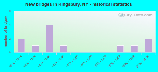
- New bridges - historical statistics
- 21910-1919
- 11920-1929
- 41930-1939
- 11940-1949
- 11980-1989
- 11990-1999
- 22000-2009
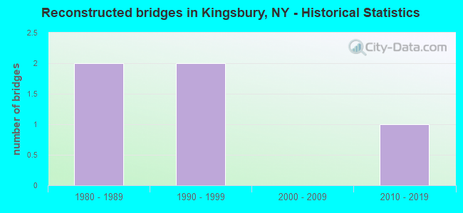
- Reconstructed bridges - Historical Statistics
- 21980-1989
- 21990-1999
- 02000-2009
- 12010-2019
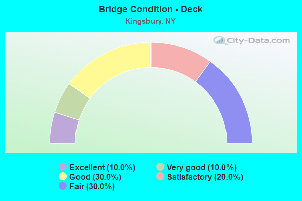
- Bridge Condition - Deck
- 10.0%Excellent
- 10.0%Very good
- 30.0%Good
- 20.0%Satisfactory
- 30.0%Fair
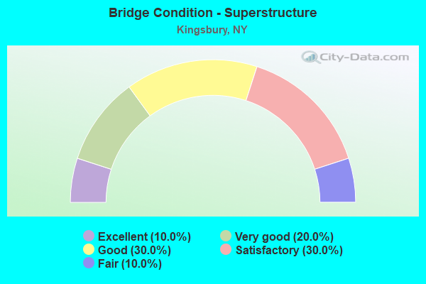
- Bridge Condition - Superstructure
- 10.0%Excellent
- 20.0%Very good
- 30.0%Good
- 30.0%Satisfactory
- 10.0%Fair
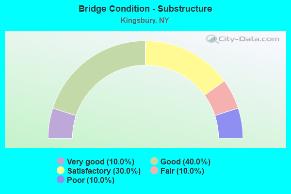
- Bridge Condition - Substructure
- 10.0%Very good
- 40.0%Good
- 30.0%Satisfactory
- 10.0%Fair
- 10.0%Poor
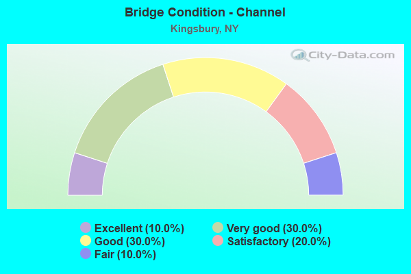
- Bridge Condition - Channel
- 10.0%Excellent
- 30.0%Very good
- 30.0%Good
- 20.0%Satisfactory
- 10.0%Fair
Find on map >> Show street view
Structure Number: 103981, Location: 2.2 MI E JCT US 4 & SH196 (Lat: 43.304703, Lng: -73.544039), Route carried "on" structure: State highway 196, Year Built: 2001, Status: Open, Structure Length: 2.59m (8.50ft), Average Daily Traffic: 6,059 (year 2020), Truck Traffic: 8%, Average Future Daily Traffic: 7,360 (year 2040), Design Load: HS 25 or greater, Features Intersected: DELAWARE & HUDSON
Minimum Vertical Clearance: 30+ m (98+ ft), Kilometerpoint: 3.540, Lanes on structure: 2, Base Highway Network: Yes, Owner: State Highway Agency, Approaching Roadway Width: 8.5m (27.9ft), Skew: 2 degrees, Material/Design: Steel, Design/Construction: Stringer/Multi-beam, Number Of Spans In Main Unit: 1, Length of Maximum Span: 24.5m (80.4ft), Curb-To-Curb Width: 8.4m (27.6ft), Out-to-Out Width: 9.4m (30.8ft)
Condition: Deck: Very good, Superstructure: Very good, Substructure: Very good, Operating Rating: 88.9 metric tons, Method Used To Determine Operating Rating: Load Factor (LF), Inventory Rating: 47.2 metric tons, Method Used To Determine Inventory Rating: Load Factor (LF), Structural Evaluation: Equal to present desirable criteria, Deck Geometry: High priority of replacement, Underclear: Better than present minimum criteria, Approach Roadway Alignment: Equal to present desirable criteria, Length Of Structure Improvement: 2.59m (8.50ft), Designated Inspection Frequency: Every 24 months, Inspection Date: May 2021, Bridge Improvement Cost: $582,000, Roadway Improvement Cost: $341,000, Total Project Cost: $923,000 ( Estimate for 2021), Deck Structure Type: Concrete Cast-file-Place, Wearing Surface/Protective System: Wearing Surface: Integral Concrete, Deck Protection: Epoxy Coated Reinforcing
Find on map >> Show street view
Structure Number: 103983, Location: 3.85 MI E JCT RTE 4 & 196 (Lat: 43.309656, Lng: -73.512944), Route carried "on" structure: State highway 196, Year Built: 1930, Year Reconstructed: 1992, Status: Open, Structure Length: 1.49m (4.89ft), Average Daily Traffic: 4,104 (year 2018), Truck Traffic: 5%, Average Future Daily Traffic: 4,281 (year 2040), Design Load: HS 25 or greater, Features Intersected: WOOD CREEK
Minimum Vertical Clearance: 30+ m (98+ ft), Kilometerpoint: 6.162, Lanes on structure: 2, Base Highway Network: Yes, Owner: State Highway Agency, Approaching Roadway Width: 8.8m (28.9ft), Skew: 4 degrees, Material/Design: Prestressed concrete, Design/Construction: Box Beam or Girders - Multiple, Number Of Spans In Main Unit: 1, Length of Maximum Span: 14.0m (45.9ft), Curb-To-Curb Width: 8.9m (29.2ft), Out-to-Out Width: 9.5m (31.2ft)
Condition: Deck: Satisfactory, Superstructure: Good, Substructure: Good, Channel: Good, Operating Rating: 84.4 metric tons, Method Used To Determine Operating Rating: Load Factor (LF), Inventory Rating: 39.0 metric tons, Method Used To Determine Inventory Rating: Load Factor (LF), Structural Evaluation: Better than present minimum criteria, Deck Geometry: Meets minimum limits, Waterway Adequacy: Equal to present minimum criteria, Approach Roadway Alignment: Equal to present desirable criteria, Length Of Structure Improvement: 1.49m (4.89ft), Designated Inspection Frequency: Every 24 months, Inspection Date: September 2020, Bridge Improvement Cost: $1,267,000, Roadway Improvement Cost: $742,000, Total Project Cost: $2,008,000 ( Estimate for 2021), Wearing Surface/Protective System: Wearing Surface: Bituminous
Find on map >> Show street view
Structure Number: 109578, Location: 2.05 MI E JCT RTE 4 & 196 (Lat: 43.305189, Lng: -73.547217), Route carried "on" structure: State highway 196, Year Built: 2001, Status: Open, Structure Length: 1.07m (3.51ft), Average Daily Traffic: 7,750 (year 2016), Truck Traffic: 5%, Average Future Daily Traffic: 7,827 (year 2039), Design Load: HS 25 or greater, Features Intersected: BOND CREEK
Minimum Vertical Clearance: 30+ m (98+ ft), Kilometerpoint: 3.266, Lanes on structure: 2, Base Highway Network: Yes, Owner: State Highway Agency, Approaching Roadway Width: 8.5m (27.9ft), Material/Design: Concrete, Design/Construction: Culvert, Number Of Spans In Main Unit: 1, Length of Maximum Span: 10.3m (33.8ft)
Condition: Channel: Fair, Culverts: Very good, Operating Rating: 74.4 metric tons, Method Used To Determine Operating Rating: Load Factor (LF), Inventory Rating: 44.5 metric tons, Method Used To Determine Inventory Rating: Load Factor (LF), Structural Evaluation: Equal to present desirable criteria, Waterway Adequacy: Superior to present desirable criteria, Approach Roadway Alignment: Equal to present desirable criteria, Length Of Structure Improvement: 1.06m (3.48ft), Designated Inspection Frequency: Every 24 months, Inspection Date: March 2021, Bridge Improvement Cost: $289,000, Roadway Improvement Cost: $169,000, Total Project Cost: $458,000 ( Estimate for 2021)
Find on map >> Show street view
Structure Number: 33058, Location: 1 MILE SOUTH OF GRANVILLE (Lat: 43.356461, Lng: -73.487278), Route carried "on" structure: County highway , Year Built: 1928, Year Reconstructed: 2001, Status: Open, Structure Length: 1.34m (4.40ft), Average Daily Traffic: 684 (year 2018), Truck Traffic: 17%, Average Future Daily Traffic: 958 (year 2038), Design Load: H 20, Features Intersected: BIG CREEK, Facility Carried by Structure: ADAMSVILLE ROAD
Minimum Vertical Clearance: 30+ m (98+ ft), Kilometerpoint: 12.695, Lanes on structure: 2, Owner: County Highway Agency, Approaching Roadway Width: 7.9m (25.9ft), Material/Design: Steel, Design/Construction: Stringer/Multi-beam, Number Of Spans In Main Unit: 1, Length of Maximum Span: 12.2m (40.0ft), Curb-To-Curb Width: 7.9m (25.9ft), Out-to-Out Width: 8.5m (27.9ft)
Condition: Deck: Good, Superstructure: Good, Substructure: Fair, Channel: Satisfactory, Operating Rating: 97.2 metric tons, Method Used To Determine Operating Rating: Load and Resistance Factor Rating (LRFR) rating reported by rating factor(RF) method using HL-93 loadings, Inventory Rating: 97.2 metric tons, Method Used To Determine Inventory Rating: Load and Resistance Factor Rating (LRFR) rating reported by rating factor(RF) method using HL-93 loadings, Structural Evaluation: Somewhat better than minimum adequacy, Deck Geometry: Somewhat better than minimum adequacy, Waterway Adequacy: Meets minimum limits, Approach Roadway Alignment: Meets minimum limits, Length Of Structure Improvement: 1.34m (4.40ft), Designated Inspection Frequency: Every 24 months, Inspection Date: April 2021, Bridge Improvement Cost: $417,000, Roadway Improvement Cost: $244,000, Total Project Cost: $661,000 ( Estimate for 2021), Deck Structure Type: Concrete Cast-file-Place, Wearing Surface/Protective System: Wearing Surface: Bituminous, Membrane: Other, Deck Protection: Epoxy Coated Reinforcing
Find on map >> Show street view
Structure Number: 330605, Location: IN PATTEN MILLS (Lat: 43.377794, Lng: -73.607533), Route carried "on" structure: County highway , Year Built: 1931, Year Reconstructed: 1985, Status: Open, Structure Length: 1.34m (4.40ft), Average Daily Traffic: 1,139 (year 2017), Truck Traffic: 10%, Average Future Daily Traffic: 1,409 (year 2040), Features Intersected: HALFWAY CREEK, Facility Carried by Structure: CR 35, VAUGHN RD.
Minimum Vertical Clearance: 30+ m (98+ ft), Kilometerpoint: 10.555, Lanes on structure: 2, Owner: County Highway Agency, Approaching Roadway Width: 7.9m (25.9ft), Material/Design: Steel, Design/Construction: Stringer/Multi-beam, Number Of Spans In Main Unit: 1, Length of Maximum Span: 12.4m (40.7ft), Curb-To-Curb Width: 7.9m (25.9ft), Out-to-Out Width: 8.5m (27.9ft)
Condition: Deck: Fair, Superstructure: Satisfactory, Substructure: Satisfactory, Channel: Satisfactory, Inventory Rating: 62.6 metric tons, Method Used To Determine Inventory Rating: Load Factor (LF), Structural Evaluation: Equal to present minimum criteria, Deck Geometry: Meets minimum limits, Waterway Adequacy: Superior to present desirable criteria, Approach Roadway Alignment: Equal to present desirable criteria, Length Of Structure Improvement: 1.34m (4.40ft), Designated Inspection Frequency: Every 24 months, Inspection Date: July 2021, Bridge Improvement Cost: $377,000, Roadway Improvement Cost: $221,000, Total Project Cost: $598,000 ( Estimate for 2021), Deck Structure Type: Concrete Cast-file-Place, Wearing Surface/Protective System: Wearing Surface: Bituminous
Find on map >> Show street view
Structure Number: 330673, Location: AT PATTENS MILLS (Lat: 43.383003, Lng: -73.604936), Route carried "on" structure: Other road , Year Built: 1942, Year Reconstructed: 1999, Status: Open, Structure Length: 1.37m (4.49ft), Average Daily Traffic: 580 (year 2017), Truck Traffic: 5%, Average Future Daily Traffic: 812 (year 2037), Design Load: H 20, Features Intersected: HALFWAY BROOK, Facility Carried by Structure: PATTENS MILLS RD
Minimum Vertical Clearance: 30+ m (98+ ft), Kilometerpoint: 0.853, Lanes on structure: 2, Owner: County Highway Agency, Approaching Roadway Width: 6.4m (21.0ft), Material/Design: Steel, Design/Construction: Stringer/Multi-beam, Number Of Spans In Main Unit: 1, Length of Maximum Span: 12.8m (42.0ft), Curb-To-Curb Width: 6.4m (21.0ft), Out-to-Out Width: 7.3m (24.0ft)
Condition: Deck: Excellent, Superstructure: Excellent, Substructure: Satisfactory, Channel: Excellent, Operating Rating: 90.1 metric tons, Method Used To Determine Operating Rating: Load and Resistance Factor Rating (LRFR) rating reported by rating factor(RF) method using HL-93 loadings, Inventory Rating: 69.3 metric tons, Method Used To Determine Inventory Rating: Load and Resistance Factor Rating (LRFR) rating reported by rating factor(RF) method using HL-93 loadings, Structural Evaluation: Equal to present minimum criteria, Deck Geometry: High priority of corrective action, Waterway Adequacy: Equal to present minimum criteria, Approach Roadway Alignment: Equal to present minimum criteria, Length Of Structure Improvement: 1.37m (4.49ft), Designated Inspection Frequency: Every 24 months, Inspection Date: June 2020, Bridge Improvement Cost: $430,000, Roadway Improvement Cost: $252,000, Total Project Cost: $682,000 ( Estimate for 2021), Deck Structure Type: Concrete Cast-file-Place, Wearing Surface/Protective System: Wearing Surface: Integral Concrete, Deck Protection: Epoxy Coated Reinforcing
Find on map >> Show street view
Structure Number: 330678, Location: 5M NE-HUDSON FALLS-OFF196 (Lat: 43.327603, Lng: -73.504919), Route carried "on" structure: County highway , Year Built: 1988, Status: Open, Structure Length: 2.38m (7.81ft), Average Daily Traffic: 47 (year 2020), Truck Traffic: 6%, Average Future Daily Traffic: 66 (year 2040), Design Load: HS 20, Features Intersected: WOOD CREEK, Facility Carried by Structure: NEW SWAMP ROAD
Minimum Vertical Clearance: 30+ m (98+ ft), Kilometerpoint: 1.883, Lanes on structure: 2, Owner: County Highway Agency, Approaching Roadway Width: 6.1m (20.0ft), Material/Design: Prestressed concrete, Design/Construction: Box Beam or Girders - Multiple, Number Of Spans In Main Unit: 1, Length of Maximum Span: 21.3m (69.9ft), Curb-To-Curb Width: 6.1m (20.0ft), Out-to-Out Width: 6.8m (22.3ft)
Condition: Deck: Good, Superstructure: Very good, Substructure: Good, Channel: Good, Operating Rating: 52.6 metric tons, Method Used To Determine Operating Rating: Load Factor (LF), Inventory Rating: 27.2 metric tons, Method Used To Determine Inventory Rating: Load Factor (LF), Structural Evaluation: Equal to present minimum criteria, Deck Geometry: Somewhat better than minimum adequacy, Waterway Adequacy: Superior to present desirable criteria, Approach Roadway Alignment: Equal to present desirable criteria, Length Of Structure Improvement: 2.37m (7.78ft), Designated Inspection Frequency: Every 24 months, Inspection Date: April 2021, Bridge Improvement Cost: $394,000, Roadway Improvement Cost: $231,000, Total Project Cost: $625,000 ( Estimate for 2021), Wearing Surface/Protective System: Wearing Surface: Bituminous, Membrane: Preformed Fabric
Find on map >> Show street view
Structure Number: 403847, Location: JCT SH 149 & CHAMP CANAL (Lat: 43.357914, Lng: -73.493906), Route carried "on" structure: State highway 149, Year Built: 1994, Status: Open, Structure Length: 8.47m (27.79ft), Average Daily Traffic: 1,293 (year 2019), Truck Traffic: 9%, Average Future Daily Traffic: 1,348 (year 2040), Design Load: HS 20, Features Intersected: CHAMPLAIN CANAL
Minimum Vertical Clearance: 5.00m (16.40ft), Kilometerpoint: 17.297, Lanes on structure: 2, Base Highway Network: Yes, Owner: State Highway Agency, Approaching Roadway Width: 8.5m (27.9ft), Navigation Control: Yes ( Vertical Clearance: 5.1m (16.7ft), Horizontal Clearance: 22.8m (74.8ft)), Material/Design: Steel, Design/Construction: Truss - Thru, Number Of Spans In Main Unit: 1, Length of Maximum Span: 83.8m (274.9ft), Curb-To-Curb Width: 8.2m (26.9ft), Out-to-Out Width: 9.9m (32.5ft)
Condition: Deck: Fair, Superstructure: Good, Substructure: Good, Channel: Very good, Operating Rating: 75.3 metric tons, Method Used To Determine Operating Rating: Load Factor (LF), Inventory Rating: 44.5 metric tons, Method Used To Determine Inventory Rating: Load Factor (LF), Structural Evaluation: Better than present minimum criteria, Deck Geometry: Meets minimum limits, Waterway Adequacy: Superior to present desirable criteria, Approach Roadway Alignment: Equal to present desirable criteria, Length Of Structure Improvement: 8.47m (27.79ft), Designated Inspection Frequency: Every 24 months, Critical Feature Inspection Frequency: Every 24 months, Inspection Date: July 2020, Critical Feature Inspection Date: July 2020, Bridge Improvement Cost: $5,491,000, Roadway Improvement Cost: $3,215,000, Total Project Cost: $8,706,000 ( Estimate for 2021), Deck Structure Type: Concrete Cast-file-Place, Wearing Surface/Protective System: Wearing Surface: Integral Concrete, Deck Protection: Epoxy Coated Reinforcing
Find on map >> Show street view
Structure Number: 403982, Location: JCT SH 196 & CHAMP CANAL (Lat: 43.304072, Lng: -73.539525), Route carried "on" structure: State highway 196, Year Built: 1938, Year Reconstructed: 2021, Status: Open, Structure Length: 10.64m (34.91ft), Average Daily Traffic: 6,059 (year 2020), Truck Traffic: 8%, Average Future Daily Traffic: 7,360 (year 2040), Design Load: H 20, Features Intersected: DIKE ROAD, CHAMPLAIN CAN
Minimum Vertical Clearance: 4.70m (15.42ft), Kilometerpoint: 3.878, Lanes on structure: 2, Lanes under structure: 2, Base Highway Network: Yes, Owner: State Highway Agency, Approaching Roadway Width: 9.1m (29.9ft), Skew: 3 degrees, Navigation Control: Yes ( Vertical Clearance: 6.7m (22.0ft), Horizontal Clearance: 51.8m (169.9ft)), Material/Design: Steel, Design/Construction: Truss - Thru, Number Of Spans In Main Unit: 1, Number Of Approach Spans: 2, Length of Maximum Span: 56.4m (185.0ft), Curb-To-Curb Width: 8.7m (28.5ft), Out-to-Out Width: 9.6m (31.5ft)
Condition: Deck: Good, Superstructure: Satisfactory, Substructure: Good, Channel: Very good, Operating Rating: 28.8 metric tons, Method Used To Determine Operating Rating: Load and Resistance Factor Rating (LRFR) rating reported by rating factor(RF) method using HL-93 loadings, Inventory Rating: 22.4 metric tons, Method Used To Determine Inventory Rating: Load and Resistance Factor Rating (LRFR) rating reported by rating factor(RF) method using HL-93 loadings, Structural Evaluation: Somewhat better than minimum adequacy, Deck Geometry: Meets minimum limits, Underclear: High priority of corrective action, Waterway Adequacy: Equal to present minimum criteria, Approach Roadway Alignment: Equal to present minimum criteria, Length Of Structure Improvement: 10.63m (34.88ft), Designated Inspection Frequency: Every 24 months, Critical Feature Inspection Frequency: Every 12 months, Inspection Date: November 2021, Critical Feature Inspection Date: November 2021, Bridge Improvement Cost: $9,671,000, Roadway Improvement Cost: $5,663,000, Total Project Cost: $15,334,000 ( Estimate for 2021), Deck Structure Type: Concrete Cast-file-Place, Wearing Surface/Protective System: Wearing Surface: Integral Concrete, Deck Protection: Epoxy Coated Reinforcing
Find on map >> Show street view
Structure Number: 441808, Location: SOUTH OF FORT ANN (Lat: 43.390064, Lng: -73.486342), Route carried "on" structure: Other road , Year Built: 1911, Year Reconstructed: 2017, Status: Posted for load, Structure Length: 7.53m (24.70ft), Average Daily Traffic: 293 (year 2017), Truck Traffic: 6%, Average Future Daily Traffic: 410 (year 2037), Features Intersected: CHAMPLAIN CANAL, Facility Carried by Structure: BALDWIN CORNERS RD
Minimum Vertical Clearance: 4.24m (13.91ft), Kilometerpoint: 0.531, Lanes on structure: 1, Owner: State Highway Agency, Approaching Roadway Width: 5.2m (17.1ft), Navigation Control: Yes ( Vertical Clearance: 4.8m (15.7ft), Horizontal Clearance: 13.7m (44.9ft)), Material/Design: Steel, Design/Construction: Truss - Thru, Number Of Spans In Main Unit: 1, Number Of Approach Spans: 2, Length of Maximum Span: 45.7m (149.9ft), Curb-To-Curb Width: 4.5m (14.8ft), Out-to-Out Width: 5.1m (16.7ft)
Condition: Deck: Satisfactory, Superstructure: Satisfactory, Substructure: Satisfactory, Channel: Very good, Operating Rating: 38.1 metric tons, Method Used To Determine Operating Rating: Load Factor (LF), Inventory Rating: 26.3 metric tons, Method Used To Determine Inventory Rating: Load Factor (LF), Structural Evaluation: Equal to present minimum criteria, Deck Geometry: High priority of replacement, Waterway Adequacy: Superior to present desirable criteria, Approach Roadway Alignment: Meets minimum limits, Bridge Posting: Required (Relationship of Operating Rating to Maximum Legal Load: > 39.9% below), Length Of Structure Improvement: 7.52m (24.67ft), Designated Inspection Frequency: Every 12 months, Critical Feature Inspection Frequency: Every 12 months, Inspection Date: October 2021, Critical Feature Inspection Date: October 2021, Bridge Improvement Cost: $2,429,000, Roadway Improvement Cost: $1,422,000, Total Project Cost: $3,851,000 ( Estimate for 2021), Deck Structure Type: Open Grating, Wearing Surface/Protective System: Wearing Surface: Other
Find on map >> Show street view
Structure Number: 441809, Location: JCT N SWAMP RD & CHAMP C (Lat: 43.331703, Lng: -73.510442), Route carried "on" structure: Other road , Year Built: 1911, Status: Posted for load, Structure Length: 8.60m (28.22ft), Average Daily Traffic: 47 (year 2020), Truck Traffic: 6%, Average Future Daily Traffic: 66 (year 2040), Features Intersected: CHAMPLAIN CANAL, Facility Carried by Structure: NEW SWAMP ROAD
Minimum Vertical Clearance: 4.11m (13.48ft), Kilometerpoint: 2.832, Lanes on structure: 1, Owner: State Highway Agency, Approaching Roadway Width: 4.9m (16.1ft), Navigation Control: Yes ( Vertical Clearance: 4.8m (15.7ft), Horizontal Clearance: 13.7m (44.9ft)), Material/Design: Steel, Design/Construction: Truss - Thru, Number Of Spans In Main Unit: 1, Number Of Approach Spans: 2, Length of Maximum Span: 55.1m (180.8ft), Curb-To-Curb Width: 4.5m (14.8ft), Out-to-Out Width: 5.2m (17.1ft)
Condition: Deck: Fair, Superstructure: Fair, Substructure: Poor, Channel: Good, Operating Rating: 27.2 metric tons, Method Used To Determine Operating Rating: Load Factor (LF), Inventory Rating: 19.1 metric tons, Method Used To Determine Inventory Rating: Load Factor (LF), Structural Evaluation: Meets minimum limits, Deck Geometry: High priority of corrective action, Waterway Adequacy: Superior to present desirable criteria, Approach Roadway Alignment: High priority of replacement, Bridge Posting: Required (Relationship of Operating Rating to Maximum Legal Load: > 39.9% below), Length Of Structure Improvement: 8.59m (28.18ft), Designated Inspection Frequency: Every 12 months, Critical Feature Inspection Frequency: Every 12 months, Inspection Date: October 2021, Critical Feature Inspection Date: October 2021, Bridge Improvement Cost: $2,792,000, Roadway Improvement Cost: $1,635,000, Total Project Cost: $4,426,000 ( Estimate for 2021), Deck Structure Type: Open Grating, Wearing Surface/Protective System: Wearing Surface: Other
Find on map >> Show street view
Structure Number: 403982, Location: JCT SH 196 & CHAMP CANAL (Lat: 43.304072, Lng: -73.539525), Route carried "under" structure: ServiceOther road , Year Built: 1938, Structure Length: 0. m, Average Daily Traffic: 37 (year 1985), Features Intersected: DIKE ROAD, CHAMPLAIN CAN, Facility Carried by Structure: RTE 196
Minimum Vertical Clearance: 4.01m (13.16ft), Kilometerpoint: 0.000, Lanes on structure: 2, Lanes under structure: 2, Material/Design: Steel, Design/Construction: Truss - Thru, Length of Maximum Span: 56.4m (185.0ft)