Bridge Statistics for Kingston, Pennsylvania (PA)
Condition, Traffic, Stress, Structural Evaluation, Project Costs
- National Bridge Inventory (NBI) Statistics
- 11Number of bridges
- 92ft / 28.3mTotal length
- $2,089,000Total costs
- 154,471Total average daily traffic
- 6,517Total average daily truck traffic
- National Bridge Inventory (NBI) Registered Bridges for Kingston
- No street view available for this location
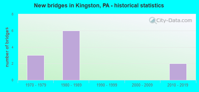
- New bridges - historical statistics
- 31970-1979
- 61980-1989
- 22010-2019
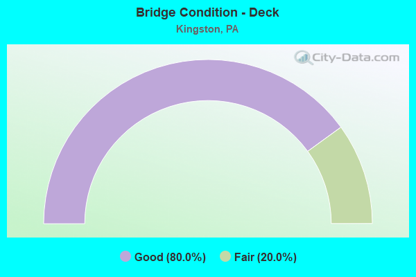
- Bridge Condition - Deck
- 80.0%Good
- 20.0%Fair
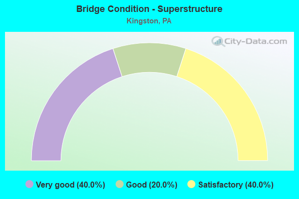
- Bridge Condition - Superstructure
- 40.0%Very good
- 20.0%Good
- 40.0%Satisfactory
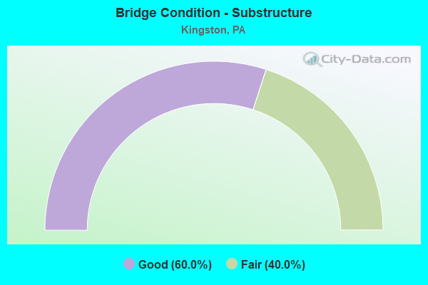
- Bridge Condition - Substructure
- 60.0%Good
- 40.0%Fair
Find on map >> Show street view
Structure Number: 23882, Location: KINGSTON BORO OVER TR 11 (Lat: 41.275697, Lng: -75.882275), Route carried "on" structure: State highway 309, Year Built: 1980, Status: Open, Structure Length: 5.03m (16.50ft), Average Daily Traffic: 31,996 (year 2021), Truck Traffic: 4%, Average Future Daily Traffic: 45,364 (year 2032), Design Load: HS 20, Features Intersected: TR 11 WYOMING AVENUE
Minimum Vertical Clearance: 30+ m (98+ ft), Kilometerpoint: 44.722, Lanes on structure: 2, Lanes under structure: 5, Base Highway Network: Yes, Owner: State Highway Agency, Approaching Roadway Width: 24.1m (79.1ft), Skew: 31 degrees, Material/Design: Prestressed concrete, Design/Construction: Stringer/Multi-beam, Number Of Spans In Main Unit: 3, Length of Maximum Span: 29.6m (97.1ft), Curb or Sidewalk Widths: Left: 0.2m (0.7ft), Right: 0.2m (0.7ft), Curb-To-Curb Width: 24.1m (79.1ft), Out-to-Out Width: 26.1m (85.6ft)
Condition: Deck: Fair, Superstructure: Satisfactory, Substructure: Fair, Operating Rating: 86.2 metric tons, Method Used To Determine Operating Rating: Load Factor (LF), Inventory Rating: 27.2 metric tons, Method Used To Determine Inventory Rating: Load Factor (LF), Structural Evaluation: Somewhat better than minimum adequacy, Deck Geometry: Superior to present desirable criteria, Underclear: Meets minimum limits, Approach Roadway Alignment: Equal to present desirable criteria, Length Of Structure Improvement: 5.00m (16.40ft), Designated Inspection Frequency: Every 24 months, Inspection Date: September 2020, Bridge Improvement Cost: $25,000, Roadway Improvement Cost: $100,000, Total Project Cost: $334,000, Deck Structure Type: Concrete Cast-file-Place, Wearing Surface/Protective System: Wearing Surface: Monolithic Concrete, Deck Protection: Epoxy Coated Reinforcing
Find on map >> Show street view
Structure Number: 23883, Location: KINGSTON BO OVER SR 1015 (Lat: 41.276694, Lng: -75.885456), Route carried "on" structure: State highway 309, Year Built: 1980, Year Reconstructed: 2009, Status: Open, Structure Length: 12.74m (41.80ft), Average Daily Traffic: 40,149 (year 2020), Truck Traffic: 5%, Average Future Daily Traffic: 55,586 (year 2032), Design Load: HS 20, Features Intersected: SR 1015 & MERCER AVE
Minimum Vertical Clearance: 30+ m (98+ ft), Kilometerpoint: 44.722, Lanes on structure: 3, Lanes under structure: 6, Base Highway Network: Yes, Owner: State Highway Agency, Approaching Roadway Width: 30.2m (99.1ft), Skew: 35 degrees, Material/Design: Steel, Design/Construction: Stringer/Multi-beam, Number Of Spans In Main Unit: 6, Length of Maximum Span: 34.7m (113.8ft), Curb or Sidewalk Widths: Left: 0.2m (0.7ft), Right: 0.2m (0.7ft), Curb-To-Curb Width: 30.2m (99.1ft), Out-to-Out Width: 32.5m (106.6ft)
Condition: Deck: Good, Superstructure: Satisfactory, Substructure: Fair, Operating Rating: 57.2 metric tons, Method Used To Determine Operating Rating: Load Factor (LF), Inventory Rating: 34.5 metric tons, Method Used To Determine Inventory Rating: Load Factor (LF), Structural Evaluation: Somewhat better than minimum adequacy, Deck Geometry: Superior to present desirable criteria, Underclear: Equal to present minimum criteria, Approach Roadway Alignment: Equal to present desirable criteria, Length Of Structure Improvement: 12.70m (41.67ft), Designated Inspection Frequency: Every 24 months, Inspection Date: September 2020, Bridge Improvement Cost: $130,000, Roadway Improvement Cost: $383,000, Total Project Cost: $1,755,000, Deck Structure Type: Concrete Cast-file-Place, Wearing Surface/Protective System: Wearing Surface: Latex Concrete, Deck Protection: Epoxy Coated Reinforcing
Find on map >> Show street view
Structure Number: 23964, Location: KINGSTON BORO OVER TR 309 (Lat: 41.271933, Lng: -75.876583), Route carried "on" structure: State highway , Year Built: 1976, Status: Open, Structure Length: 6.34m (20.80ft), Average Daily Traffic: 17,075 (year 2020), Truck Traffic: 5%, Average Future Daily Traffic: 18,871 (year 2032), Design Load: HS 20, Features Intersected: SR 0309 TR 309, Facility Carried by Structure: SR 1006 RUTTER AVE
Minimum Vertical Clearance: 30+ m (98+ ft), Kilometerpoint: 0.000, Lanes on structure: 4, Lanes under structure: 8, Owner: State Highway Agency, Approaching Roadway Width: 17.1m (56.1ft), Skew: 21 degrees, Material/Design: Steel, Design/Construction: Stringer/Multi-beam, Number Of Spans In Main Unit: 3, Length of Maximum Span: 37.2m (122.0ft), Curb or Sidewalk Widths: Left: 1.5m (4.9ft), Right: 0.2m (0.7ft), Curb-To-Curb Width: 20.1m (65.9ft), Out-to-Out Width: 22.6m (74.1ft)
Condition: Deck: Good, Superstructure: Good, Substructure: Good, Operating Rating: 53.5 metric tons, Method Used To Determine Operating Rating: Load Factor (LF), Inventory Rating: 31.8 metric tons, Method Used To Determine Inventory Rating: Load Factor (LF), Structural Evaluation: Better than present minimum criteria, Deck Geometry: Better than present minimum criteria, Underclear: High priority of corrective action, Approach Roadway Alignment: Better than present minimum criteria, Length Of Structure Improvement: 7.30m (23.95ft), Designated Inspection Frequency: Every 24 months, Inspection Date: December 2020, Deck Structure Type: Concrete Cast-file-Place, Wearing Surface/Protective System: Wearing Surface: Latex Concrete, Deck Protection: Epoxy Coated Reinforcing
Find on map >> Show street view
Structure Number: 47756, Location: PLAINS TWP .3 M S TR 309 (Lat: 41.262294, Lng: -75.866956), Route carried "on" structure: State highway , Year Built: 2012, Status: Open, Structure Length: 2.65m (8.69ft), Average Daily Traffic: 15,869 (year 2022), Truck Traffic: 2%, Average Future Daily Traffic: 19,803 (year 2033), Design Load: HL 93, Features Intersected: LUZ CO RAIL AUTHORITY, Facility Carried by Structure: SR 2004 N.RIVER ST
Minimum Vertical Clearance: 30+ m (98+ ft), Kilometerpoint: 5.057, Lanes on structure: 2, Base Highway Network: Yes, Owner: State Highway Agency, Approaching Roadway Width: 10.7m (35.1ft), Skew: 4 degrees, Material/Design: Prestressed concrete, Design/Construction: Box Beam or Girders - Single/Spread, Number Of Spans In Main Unit: 1, Length of Maximum Span: 25.9m (85.0ft), Curb or Sidewalk Widths: Left: 1.8m (5.9ft), Right: 0.2m (0.7ft), Curb-To-Curb Width: 10.4m (34.1ft), Out-to-Out Width: 13.2m (43.3ft)
Condition: Deck: Good, Superstructure: Very good, Substructure: Good, Operating Rating: 62.5 metric tons, Method Used To Determine Operating Rating: Assigned ratings based on Load and Resistance Factor Design (LRFD) reported by rating factor (RF) using HL93 loadings, Inventory Rating: 38.2 metric tons, Method Used To Determine Inventory Rating: Assigned ratings based on Load and Resistance Factor Design (LRFD) reported by rating factor (RF) using HL93 loadings, Structural Evaluation: Better than present minimum criteria, Deck Geometry: Meets minimum limits, Underclear: High priority of corrective action, Approach Roadway Alignment: Somewhat better than minimum adequacy, Designated Inspection Frequency: Every 48 months, Inspection Date: September 2020, Deck Structure Type: Concrete Cast-file-Place, Wearing Surface/Protective System: Wearing Surface: Epoxy Overlay, Deck Protection: Epoxy Coated Reinforcing
Find on map >> Show street view
Structure Number: 54656, Location: 0.6M W SR 309 (Lat: 41.298589, Lng: -75.933717), Route carried "on" structure: County highway , Year Built: 2017, Status: Open, Structure Length: 1.55m (5.09ft), Average Daily Traffic: 500 (year 2018), Truck Traffic: 5%, Average Future Daily Traffic: 650 (year 2035), Design Load: HL 93, Features Intersected: HUNTSVILLE CREEK, Facility Carried by Structure: HILLSIDE ROAD CR16
Minimum Vertical Clearance: 30+ m (98+ ft), Kilometerpoint: 1.609, Lanes on structure: 2, Owner: County Highway Agency, Approaching Roadway Width: 7.0m (23.0ft), Skew: 4 degrees, Material/Design: Prestressed concrete, Design/Construction: Box Beam or Girders - Single/Spread, Number Of Spans In Main Unit: 1, Length of Maximum Span: 15.5m (50.9ft), Curb or Sidewalk Widths: Left: 0.2m (0.7ft), Right: 0.2m (0.7ft), Curb-To-Curb Width: 9.8m (32.2ft), Out-to-Out Width: 12.6m (41.3ft)
Condition: Deck: Good, Superstructure: Very good, Substructure: Good, Channel: Satisfactory, Operating Rating: 54.8 metric tons, Method Used To Determine Operating Rating: Assigned ratings based on Load and Resistance Factor Design (LRFD) reported by rating factor (RF) using HL93 loadings, Inventory Rating: 39.9 metric tons, Method Used To Determine Inventory Rating: Assigned ratings based on Load and Resistance Factor Design (LRFD) reported by rating factor (RF) using HL93 loadings, Structural Evaluation: Better than present minimum criteria, Deck Geometry: Equal to present minimum criteria, Waterway Adequacy: Equal to present desirable criteria, Approach Roadway Alignment: Better than present minimum criteria, Designated Inspection Frequency: Every 24 months, Inspection Date: October 2019, Deck Structure Type: Concrete Cast-file-Place, Wearing Surface/Protective System: Wearing Surface: Monolithic Concrete, Deck Protection: Epoxy Coated Reinforcing
Find on map >> Show street view
Structure Number: 23882, Location: KINGSTON BORO OVER TR 11 (Lat: 41.275697, Lng: -75.882275), Route carried "under" structure: US 11, Year Built: 1980, Structure Length: 0. m, Average Daily Traffic: 8,173 (year 2021), Truck Traffic: 3%, Features Intersected: TR 11 WYOMING AVENUE, Facility Carried by Structure: SR 0309 TR 309
Minimum Vertical Clearance: 4.48m (14.70ft), Kilometerpoint: 44.212, Lanes on structure: 2, Lanes under structure: 3, Material/Design: Prestressed concrete, Design/Construction: Stringer/Multi-beam, Length of Maximum Span: 29.6m (97.1ft)
Find on map >> Show street view
Structure Number: 23882, Location: KINGSTON BORO OVER TR 11 (Lat: 41.275697, Lng: -75.882275), Route carried "under" structure: US 11, Year Built: 1980, Structure Length: 0. m, Average Daily Traffic: 8,613 (year 2021), Truck Traffic: 4%, Features Intersected: TR 11 WYOMING AVENUE, Facility Carried by Structure: SR 0309 TR 309
Minimum Vertical Clearance: 4.50m (14.76ft), Kilometerpoint: 44.209, Lanes on structure: 2, Lanes under structure: 2, Material/Design: Prestressed concrete, Design/Construction: Stringer/Multi-beam, Length of Maximum Span: 29.6m (97.1ft)
Find on map >> Show street view
Structure Number: 23883, Location: KINGSTON BO OVER SR 1015 (Lat: 41.276694, Lng: -75.885456), Route carried "under" structure: City street , Year Built: 1980, Structure Length: 0. m, Average Daily Traffic: 100 (year 2003), Truck Traffic: 10%, Features Intersected: SR 1015 & MERCER AVE, Facility Carried by Structure: TR 309, RAMPS E&F
Minimum Vertical Clearance: 4.67m (15.32ft), Kilometerpoint: 0.000, Lanes on structure: 3, Lanes under structure: 4, Material/Design: Steel, Design/Construction: Stringer/Multi-beam, Length of Maximum Span: 34.7m (113.8ft)
Find on map >> Show street view
Structure Number: 23883, Location: KINGSTON BO OVER SR 1015 (Lat: 41.276694, Lng: -75.885456), Route carried "under" structure: City street , Year Built: 1980, Structure Length: 0. m, Features Intersected: SR 1015 & MERCER AVE, Facility Carried by Structure: TR 309, RAMPS E&F
Minimum Vertical Clearance: 4.98m (16.34ft), Kilometerpoint: 0.000, Lanes on structure: 3, Lanes under structure: 2, Material/Design: Steel, Design/Construction: Stringer/Multi-beam, Length of Maximum Span: 34.7m (113.8ft)
Find on map >> Show street view
Structure Number: 23964, Location: KINGSTON BORO OVER TR 309 (Lat: 41.271933, Lng: -75.876583), Route carried "under" structure: State highway 309, Year Built: 1976, Structure Length: 0. m, Average Daily Traffic: 15,817 (year 2021), Truck Traffic: 5%, Features Intersected: SR 0309 TR 309, Facility Carried by Structure: SR 1006 RUTTER AVE
Minimum Vertical Clearance: 4.80m (15.75ft), Kilometerpoint: 44.230, Lanes on structure: 4, Lanes under structure: 4, Material/Design: Steel, Design/Construction: Stringer/Multi-beam, Length of Maximum Span: 37.2m (122.0ft)
Find on map >> Show street view
Structure Number: 23964, Location: KINGSTON BORO OVER TR 309 (Lat: 41.271933, Lng: -75.876583), Route carried "under" structure: State highway 309, Year Built: 1976, Structure Length: 0. m, Average Daily Traffic: 16,179 (year 2021), Truck Traffic: 4%, Features Intersected: SR 0309 TR 309, Facility Carried by Structure: SR 1006 RUTTER AVE
Minimum Vertical Clearance: 4.80m (15.75ft), Kilometerpoint: 44.112, Lanes on structure: 4, Lanes under structure: 4, Material/Design: Steel, Design/Construction: Stringer/Multi-beam, Length of Maximum Span: 37.2m (122.0ft)