Bridge Statistics for Kinnelon, New Jersey (NJ)
Condition, Traffic, Stress, Structural Evaluation, Project Costs
- National Bridge Inventory (NBI) Statistics
- 24Number of bridges
- 197ft / 60.3mTotal length
- $10,828,000Total costs
- 585,333Total average daily traffic
- 42,515Total average daily truck traffic
- National Bridge Inventory (NBI) Registered Bridges for Kinnelon
- No street view available for this location
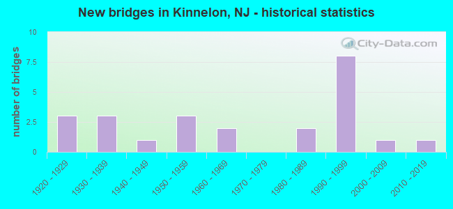
- New bridges - historical statistics
- 31920-1929
- 31930-1939
- 11940-1949
- 31950-1959
- 21960-1969
- 21980-1989
- 81990-1999
- 12000-2009
- 12010-2019
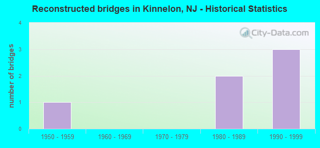
- Reconstructed bridges - Historical Statistics
- 11950-1959
- 01960-1969
- 01970-1979
- 21980-1989
- 31990-1999
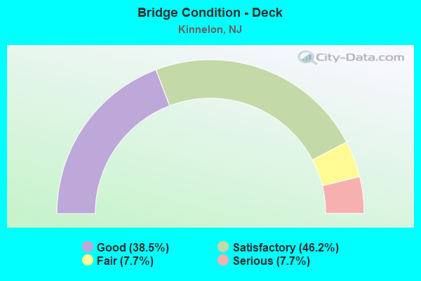
- Bridge Condition - Deck
- 38.5%Good
- 46.2%Satisfactory
- 7.7%Fair
- 7.7%Serious
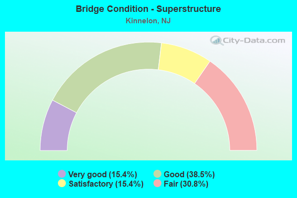
- Bridge Condition - Superstructure
- 15.4%Very good
- 38.5%Good
- 15.4%Satisfactory
- 30.8%Fair
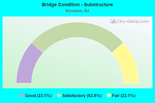
- Bridge Condition - Substructure
- 23.1%Good
- 53.8%Satisfactory
- 23.1%Fair
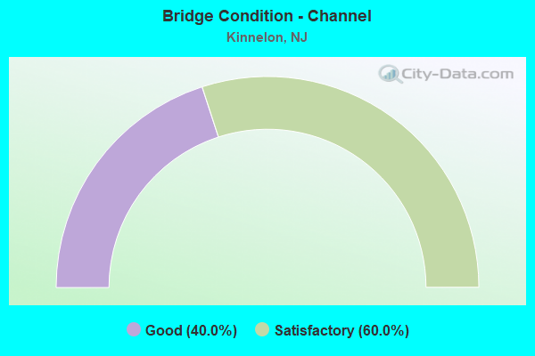
- Bridge Condition - Channel
- 40.0%Good
- 60.0%Satisfactory
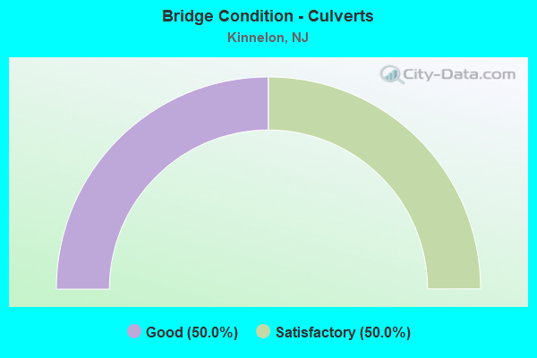
- Bridge Condition - Culverts
- 50.0%Good
- 50.0%Satisfactory
Find on map >> Show street view
Structure Number: 1400164, Location: 0.45 MILE WEST OF NJ 23 (Lat: 40.994219, Lng: -74.357739), Route carried "on" structure: City street , Year Built: 2010, Status: Open, Structure Length: 2.10m (6.89ft), Average Daily Traffic: 156 (year 2021), Truck Traffic: 1%, Average Future Daily Traffic: 187 (year 2041), Design Load: HS 25 or greater, Features Intersected: KAKEOUT BROOK, Facility Carried by Structure: STILLWATER DRIVE
Minimum Vertical Clearance: 30+ m (98+ ft), Kilometerpoint: 0.000, Lanes on structure: 2, Owner: County Highway Agency, Approaching Roadway Width: 8.5m (27.9ft), Material/Design: Steel continuous, Design/Construction: Stringer/Multi-beam, Number Of Spans In Main Unit: 2, Length of Maximum Span: 9.8m (32.2ft), Curb-To-Curb Width: 8.5m (27.9ft), Out-to-Out Width: 10.0m (32.8ft)
Condition: Deck: Good, Superstructure: Very good, Substructure: Good, Channel: Good, Inventory Rating: 78.0 metric tons, Method Used To Determine Inventory Rating: Load Factor (LF), Structural Evaluation: Better than present minimum criteria, Deck Geometry: Equal to present minimum criteria, Waterway Adequacy: Better than present minimum criteria, Approach Roadway Alignment: Equal to present minimum criteria, Designated Inspection Frequency: Every 24 months, Underwater Inspection Frequency: Every 48 months, Inspection Date: August 2021, Underwater Inspection Date: September 2021, Deck Structure Type: Concrete Cast-file-Place, Wearing Surface/Protective System: Wearing Surface: Monolithic Concrete, Deck Protection: Epoxy Coated Reinforcing
Find on map >> Show street view
Structure Number: 1400179, Location: 0.11MI N of Rckwy Valy Rd (Lat: 40.939831, Lng: -74.418150), Route carried "on" structure: County highway 618, Year Built: 1940, Year Reconstructed: 1995, Status: Open, Structure Length: 0.82m (2.69ft), Average Daily Traffic: 3,756 (year 2021), Truck Traffic: 4%, Average Future Daily Traffic: 4,507 (year 2041), Design Load: HS 25 or greater, Features Intersected: Stony Brook
Minimum Vertical Clearance: 30+ m (98+ ft), Kilometerpoint: 8.015, Lanes on structure: 2, Owner: County Highway Agency, Approaching Roadway Width: 8.5m (27.9ft), Material/Design: Prestressed concrete, Design/Construction: Slab, Number Of Spans In Main Unit: 1, Length of Maximum Span: 7.0m (23.0ft), Curb-To-Curb Width: 9.9m (32.5ft), Out-to-Out Width: 11.0m (36.1ft)
Condition: Deck: Satisfactory, Superstructure: Good, Substructure: Satisfactory, Channel: Good, Inventory Rating: 84.4 metric tons, Method Used To Determine Inventory Rating: Load Factor (LF), Structural Evaluation: Equal to present minimum criteria, Deck Geometry: Meets minimum limits, Waterway Adequacy: Equal to present desirable criteria, Approach Roadway Alignment: Somewhat better than minimum adequacy, Designated Inspection Frequency: Every 24 months, Inspection Date: August 2021, Deck Structure Type: Concrete Cast-file-Place, Wearing Surface/Protective System: Wearing Surface: Monolithic Concrete, Deck Protection: Epoxy Coated Reinforcing
Find on map >> Show street view
Structure Number: 1400183, Location: 1.6 MI N OF RCKWY VAL RD (Lat: 40.958569, Lng: -74.409419), Route carried "on" structure: County highway 618, Year Built: 1929, Year Reconstructed: 1999, Status: Open, Structure Length: 0.79m (2.59ft), Average Daily Traffic: 3,878 (year 2021), Truck Traffic: 4%, Average Future Daily Traffic: 4,654 (year 2041), Features Intersected: Beaver Brook
Minimum Vertical Clearance: 30+ m (98+ ft), Kilometerpoint: 10.493, Lanes on structure: 2, Owner: County Highway Agency, Approaching Roadway Width: 7.6m (24.9ft), Skew: 2 degrees, Material/Design: Steel, Design/Construction: Stringer/Multi-beam, Number Of Spans In Main Unit: 1, Length of Maximum Span: 7.3m (24.0ft), Curb or Sidewalk Widths: Left: 0.3m (1.0ft), Right: 0.3m (1.0ft), Curb-To-Curb Width: 11.3m (37.1ft), Out-to-Out Width: 12.7m (41.7ft)
Condition: Deck: Fair, Superstructure: Fair, Substructure: Fair, Channel: Satisfactory, Operating Rating: 79.8 metric tons, Method Used To Determine Operating Rating: Load Factor (LF), Inventory Rating: 48.1 metric tons, Method Used To Determine Inventory Rating: Load Factor (LF), Structural Evaluation: Somewhat better than minimum adequacy, Deck Geometry: Somewhat better than minimum adequacy, Waterway Adequacy: Superior to present desirable criteria, Approach Roadway Alignment: Equal to present minimum criteria, Designated Inspection Frequency: Every 24 months, Inspection Date: August 2021, Deck Structure Type: Concrete Cast-file-Place, Wearing Surface/Protective System: Wearing Surface: Bituminous
Find on map >> Show street view
Structure Number: 1400196, Location: 0.76 Mile West of NJ 23 (Lat: 40.994031, Lng: -74.359831), Route carried "on" structure: City street , Year Built: 1922, Year Reconstructed: 1964, Status: Open, Structure Length: 0.73m (2.40ft), Average Daily Traffic: 2,792 (year 2021), Truck Traffic: 3%, Average Future Daily Traffic: 3,350 (year 2041), Features Intersected: Kakeout Brook, Facility Carried by Structure: Kakeout Road
Minimum Vertical Clearance: 30+ m (98+ ft), Kilometerpoint: 1.561, Lanes on structure: 2, Owner: County Highway Agency, Approaching Roadway Width: 6.7m (22.0ft), Material/Design: Steel, Design/Construction: Stringer/Multi-beam, Number Of Spans In Main Unit: 1, Length of Maximum Span: 6.7m (22.0ft), Curb-To-Curb Width: 11.5m (37.7ft), Out-to-Out Width: 11.8m (38.7ft)
Condition: Deck: Satisfactory, Superstructure: Fair, Substructure: Satisfactory, Channel: Satisfactory, Operating Rating: 71.7 metric tons, Method Used To Determine Operating Rating: Load Factor (LF), Inventory Rating: 42.6 metric tons, Method Used To Determine Inventory Rating: Load Factor (LF), Structural Evaluation: Somewhat better than minimum adequacy, Deck Geometry: Somewhat better than minimum adequacy, Waterway Adequacy: Better than present minimum criteria, Approach Roadway Alignment: Better than present minimum criteria, Designated Inspection Frequency: Every 24 months, Inspection Date: July 2021, Deck Structure Type: Corrugated Steel, Wearing Surface/Protective System: Wearing Surface: Bituminous
Find on map >> Show street view
Structure Number: 1400198, Location: 2.0 mi. South of NJ 23 (Lat: 40.969681, Lng: -74.361739), Route carried "on" structure: County highway 511, Year Built: 2007, Status: Open, Structure Length: 0.61m (2.00ft), Average Daily Traffic: 5,641 (year 2021), Truck Traffic: 3%, Average Future Daily Traffic: 6,769 (year 2041), Design Load: HS 25 or greater, Features Intersected: TributaryToTaylortownRe
Minimum Vertical Clearance: 30.45m (99.90ft), Kilometerpoint: 24.285, Lanes on structure: 2, Owner: County Highway Agency, Approaching Roadway Width: 10.1m (33.1ft), Material/Design: Concrete, Design/Construction: Culvert, Number Of Spans In Main Unit: 1, Length of Maximum Span: 6.1m (20.0ft), Curb-To-Curb Width: 10.0m (32.8ft), Out-to-Out Width: 11.4m (37.4ft)
Condition: Channel: Satisfactory, Culverts: Good, Operating Rating: 85.3 metric tons, Method Used To Determine Operating Rating: Load Factor (LF), Inventory Rating: 50.8 metric tons, Method Used To Determine Inventory Rating: Load Factor (LF), Structural Evaluation: Better than present minimum criteria, Deck Geometry: Meets minimum limits, Waterway Adequacy: Equal to present desirable criteria, Approach Roadway Alignment: Equal to present desirable criteria, Designated Inspection Frequency: Every 24 months, Inspection Date: August 2021, Wearing Surface/Protective System: Wearing Surface: Bituminous
Find on map >> Show street view
Structure Number: 1400284, Location: 0.2 MI EAST OF I-287 (Lat: 40.972450, Lng: -74.320461), Route carried "on" structure: City street , Year Built: 1993, Status: Open, Structure Length: 0.94m (3.08ft), Average Daily Traffic: 218 (year 2021), Truck Traffic: 1%, Average Future Daily Traffic: 262 (year 2041), Features Intersected: Tributary to East Ditch, Facility Carried by Structure: Mountain Ave
Minimum Vertical Clearance: 30+ m (98+ ft), Kilometerpoint: 0.000, Lanes on structure: 2, Owner: County Highway Agency, Approaching Roadway Width: 7.9m (25.9ft), Skew: 1 degrees, Material/Design: Concrete, Design/Construction: Culvert, Number Of Spans In Main Unit: 2, Length of Maximum Span: 4.6m (15.1ft)
Condition: Channel: Good, Culverts: Good, Operating Rating: 54.4 metric tons, Method Used To Determine Operating Rating: Load Factor (LF), Inventory Rating: 32.7 metric tons, Method Used To Determine Inventory Rating: Load Factor (LF), Structural Evaluation: Better than present minimum criteria, Waterway Adequacy: Equal to present desirable criteria, Approach Roadway Alignment: Equal to present desirable criteria, Designated Inspection Frequency: Every 24 months, Inspection Date: July 2021
Find on map >> Show street view
Structure Number: 1400348, Location: 0.47 MI WEST OF CR 618 (Lat: 40.940531, Lng: -74.427039), Route carried "on" structure: City street , Year Built: 1986, Status: Open, Structure Length: 1.71m (5.61ft), Average Daily Traffic: 3,146 (year 2021), Truck Traffic: 4%, Average Future Daily Traffic: 3,775 (year 2041), Design Load: HS 20+Mod, Features Intersected: Stony Brook, Facility Carried by Structure: Rockaway Valley Rd
Minimum Vertical Clearance: 30+ m (98+ ft), Kilometerpoint: 5.279, Lanes on structure: 2, Owner: County Highway Agency, Approaching Roadway Width: 7.9m (25.9ft), Material/Design: Prestressed concrete, Design/Construction: Box Beam or Girders - Multiple, Number Of Spans In Main Unit: 1, Length of Maximum Span: 15.8m (51.8ft), Curb or Sidewalk Widths: Left: 0.2m (0.7ft), Right: 0.2m (0.7ft), Curb-To-Curb Width: 8.8m (28.9ft), Out-to-Out Width: 9.8m (32.2ft)
Condition: Deck: Satisfactory, Superstructure: Good, Substructure: Good, Channel: Good, Operating Rating: 47.2 metric tons, Method Used To Determine Operating Rating: Load Factor (LF), Inventory Rating: 28.1 metric tons, Method Used To Determine Inventory Rating: Load Factor (LF), Structural Evaluation: Better than present minimum criteria, Deck Geometry: Meets minimum limits, Waterway Adequacy: Equal to present desirable criteria, Approach Roadway Alignment: Equal to present minimum criteria, Designated Inspection Frequency: Every 24 months, Inspection Date: July 2021, Deck Structure Type: Concrete Cast-file-Place, Wearing Surface/Protective System: Wearing Surface: Monolithic Concrete, Deck Protection: Epoxy Coated Reinforcing
Find on map >> Show street view
Structure Number: 1405152, Location: 1.07 MI SO OF I287 JUNC. (Lat: 40.977419, Lng: -74.295489), Route carried "on" structure: State highway 23, Year Built: 1934, Year Reconstructed: 1987, Status: Open, Structure Length: 4.88m (16.01ft), Average Daily Traffic: 68,835 (year 2021), Truck Traffic: 4%, Average Future Daily Traffic: 82,602 (year 2041), Design Load: HS 20+Mod, Features Intersected: POMPTON INDUSTRIAL TRACK
Minimum Vertical Clearance: 30+ m (98+ ft), Kilometerpoint: 18.974, Lanes on structure: 6, Base Highway Network: Yes, Owner: State Highway Agency, Approaching Roadway Width: 30.8m (101.0ft), Skew: 33 degrees, Material/Design: Steel, Design/Construction: Stringer/Multi-beam, Number Of Spans In Main Unit: 3, Length of Maximum Span: 18.3m (60.0ft), Curb or Sidewalk Widths: Left: 1.8m (5.9ft), Right: 1.8m (5.9ft), Curb-To-Curb Width: 28.5m (93.5ft), Out-to-Out Width: 33.6m (110.2ft)
Condition: Deck: Satisfactory, Superstructure: Fair, Substructure: Fair, Operating Rating: 86.2 metric tons, Method Used To Determine Operating Rating: Load Factor (LF), Inventory Rating: 51.7 metric tons, Method Used To Determine Inventory Rating: Load Factor (LF), Structural Evaluation: Somewhat better than minimum adequacy, Deck Geometry: Superior to present desirable criteria, Underclear: Meets minimum limits, Approach Roadway Alignment: Equal to present desirable criteria, Designated Inspection Frequency: Every 24 months, Inspection Date: March 2021, Deck Structure Type: Concrete Cast-file-Place, Wearing Surface/Protective System: Wearing Surface: Monolithic Concrete, Deck Protection: Epoxy Coated Reinforcing
Find on map >> Show street view
Structure Number: 1405156, Location: 4.13 MI N of I-287 (Lat: 41.011219, Lng: -74.369311), Route carried "on" structure: State highway 23, Year Built: 1934, Status: Open, Structure Length: 15.64m (51.31ft), Average Daily Traffic: 43,878 (year 2021), Truck Traffic: 4%, Average Future Daily Traffic: 52,654 (year 2041), Design Load: H 20, Features Intersected: PEQU RIV,RR, HMBG TPK SB
Minimum Vertical Clearance: 30+ m (98+ ft), Kilometerpoint: 27.262, Lanes on structure: 4, Lanes under structure: 1, Base Highway Network: Yes, Owner: State Highway Agency, Approaching Roadway Width: 15.8m (51.8ft), Skew: 39 degrees, Material/Design: Steel continuous, Design/Construction: Girder and Floorbeam System, Number Of Spans In Main Unit: 6, Number Of Approach Spans: 2, Length of Maximum Span: 22.9m (75.1ft), Curb or Sidewalk Widths: Left: 0.3m (1.0ft), Right: 0.3m (1.0ft), Curb-To-Curb Width: 15.8m (51.8ft), Out-to-Out Width: 18.1m (59.4ft)
Condition: Deck: Serious, Superstructure: Fair, Substructure: Fair, Channel: Satisfactory, Operating Rating: 45.4 metric tons, Method Used To Determine Operating Rating: Load Factor (LF), Inventory Rating: 27.2 metric tons, Method Used To Determine Inventory Rating: Load Factor (LF), Structural Evaluation: Somewhat better than minimum adequacy, Deck Geometry: Meets minimum limits, Underclear: High priority of corrective action, Waterway Adequacy: Superior to present desirable criteria, Approach Roadway Alignment: Equal to present minimum criteria, Length Of Structure Improvement: 15.64m (51.31ft), Designated Inspection Frequency: Every 24 months, Critical Feature Inspection Frequency: Every 24 months, Inspection Date: March 2021, Critical Feature Inspection Date: March 2021, Bridge Improvement Cost: $5,233,000, Roadway Improvement Cost: $785,000, Total Project Cost: $8,985,000 ( Estimate for 2021), Deck Structure Type: Concrete Cast-file-Place, Wearing Surface/Protective System: Wearing Surface: Bituminous, Membrane: Other
Find on map >> Show street view
Structure Number: 142017, Location: 2.10 MI NORTH OF ROCK RIV (Lat: 40.915669, Lng: -74.369919), Route carried "on" structure: Interstate 287, Year Built: 1962, Year Reconstructed: 1991, Status: Open, Structure Length: 5.46m (17.91ft), Average Daily Traffic: 50,562 (year 2020), Truck Traffic: 9%, Average Future Daily Traffic: 61,695 (year 2040), Design Load: HS 20, Features Intersected: MAIN ST, CROOKED BRK
Minimum Vertical Clearance: 30+ m (98+ ft), Kilometerpoint: 75.816, Lanes on structure: 4, Lanes under structure: 3, Base Highway Network: Yes, Owner: State Highway Agency, Approaching Roadway Width: 21.3m (69.9ft), Skew: 1 degrees, Material/Design: Prestressed concrete, Design/Construction: Stringer/Multi-beam, Number Of Spans In Main Unit: 3, Length of Maximum Span: 22.3m (73.2ft), Curb-To-Curb Width: 21.3m (69.9ft), Out-to-Out Width: 22.2m (72.8ft)
Condition: Deck: Good, Superstructure: Satisfactory, Substructure: Satisfactory, Channel: Good, Operating Rating: 64.4 metric tons, Method Used To Determine Operating Rating: Load Factor (LF), Inventory Rating: 38.1 metric tons, Method Used To Determine Inventory Rating: Load Factor (LF), Structural Evaluation: Equal to present minimum criteria, Deck Geometry: Better than present minimum criteria, Underclear: High priority of corrective action, Waterway Adequacy: Superior to present desirable criteria, Approach Roadway Alignment: Equal to present desirable criteria, Length Of Structure Improvement: 5.49m (18.01ft), Designated Inspection Frequency: Every 24 months, Inspection Date: March 2020, Bridge Improvement Cost: $451,000, Roadway Improvement Cost: $191,000, Total Project Cost: $849,000 ( Estimate for 2020), Deck Structure Type: Concrete Cast-file-Place, Wearing Surface/Protective System: Wearing Surface: Latex Concrete, Deck Protection: Epoxy Coated Reinforcing
Find on map >> Show street view
Structure Number: 1420175, Location: 1.05 MI N OF JUNC. US 202 (Lat: 40.927681, Lng: -74.358531), Route carried "on" structure: Interstate 287, Year Built: 1991, Status: Open, Structure Length: 3.60m (11.81ft), Average Daily Traffic: 84,284 (year 2021), Truck Traffic: 9%, Average Future Daily Traffic: 101,140 (year 2041), Design Load: HS 20+Mod, Features Intersected: OLD LANE
Minimum Vertical Clearance: 30+ m (98+ ft), Kilometerpoint: 77.506, Lanes on structure: 6, Lanes under structure: 2, Base Highway Network: Yes, Owner: State Highway Agency, Approaching Roadway Width: 36.6m (120.1ft), Skew: 33 degrees, Material/Design: Prestressed concrete, Design/Construction: Stringer/Multi-beam, Number Of Spans In Main Unit: 1, Length of Maximum Span: 35.1m (115.2ft), Curb-To-Curb Width: 35.8m (117.5ft), Out-to-Out Width: 37.6m (123.4ft)
Condition: Deck: Good, Superstructure: Good, Substructure: Good, Inventory Rating: 34.5 metric tons, Method Used To Determine Inventory Rating: Load Factor (LF), Structural Evaluation: Better than present minimum criteria, Deck Geometry: Superior to present desirable criteria, Underclear: Better than present minimum criteria, Approach Roadway Alignment: Equal to present desirable criteria, Designated Inspection Frequency: Every 24 months, Inspection Date: April 2021, Deck Structure Type: Concrete Cast-file-Place, Wearing Surface/Protective System: Wearing Surface: Latex Concrete, Deck Protection: Epoxy Coated Reinforcing
Find on map >> Show street view
Structure Number: 1420177, Location: 1.5 MI N. OF JUNC. RT 202 (Lat: 40.934361, Lng: -74.354919), Route carried "on" structure: City street , Year Built: 1991, Status: Open, Structure Length: 7.16m (23.49ft), Average Daily Traffic: 175 (year 2020), Truck Traffic: 1%, Average Future Daily Traffic: 210 (year 2040), Design Load: HS 20+Mod, Features Intersected: I-287, Facility Carried by Structure: WAUGHAW ROAD
Minimum Vertical Clearance: 30+ m (98+ ft), Kilometerpoint: 0.000, Lanes on structure: 2, Lanes under structure: 6, Owner: State Highway Agency, Approaching Roadway Width: 9.1m (29.9ft), Material/Design: Prestressed concrete, Design/Construction: Stringer/Multi-beam, Number Of Spans In Main Unit: 2, Length of Maximum Span: 35.1m (115.2ft), Curb or Sidewalk Widths: Left: 1.8m (5.9ft), Right: 1.8m (5.9ft), Curb-To-Curb Width: 9.1m (29.9ft), Out-to-Out Width: 13.4m (44.0ft)
Condition: Deck: Satisfactory, Superstructure: Very good, Substructure: Satisfactory, Operating Rating: 61.7 metric tons, Method Used To Determine Operating Rating: Load Factor (LF), Inventory Rating: 36.3 metric tons, Method Used To Determine Inventory Rating: Load Factor (LF), Structural Evaluation: Equal to present minimum criteria, Deck Geometry: Equal to present minimum criteria, Underclear: Equal to present minimum criteria, Approach Roadway Alignment: Equal to present desirable criteria, Designated Inspection Frequency: Every 24 months, Inspection Date: September 2020, Deck Structure Type: Concrete Cast-file-Place, Wearing Surface/Protective System: Deck Protection: Epoxy Coated Reinforcing
Find on map >> Show street view
Structure Number: 1420178, Location: 2.76 MI. NORTH OF US 202 (Lat: 40.949681, Lng: -74.343650), Route carried "on" structure: Other road , Year Built: 1991, Status: Open, Structure Length: 5.88m (19.29ft), Average Daily Traffic: 152 (year 2021), Truck Traffic: 1%, Average Future Daily Traffic: 182 (year 2041), Design Load: HS 20, Features Intersected: I-287, Facility Carried by Structure: BROOK VALLEY ROAD
Minimum Vertical Clearance: 30+ m (98+ ft), Kilometerpoint: 0.000, Lanes on structure: 2, Lanes under structure: 7, Owner: State Highway Agency, Approaching Roadway Width: 12.5m (41.0ft), Skew: 3 degrees, Material/Design: Prestressed concrete, Design/Construction: Stringer/Multi-beam, Number Of Spans In Main Unit: 2, Length of Maximum Span: 29.0m (95.1ft), Curb or Sidewalk Widths: Left: 1.8m (5.9ft), Right: 0.0m, Curb-To-Curb Width: 12.5m (41.0ft), Out-to-Out Width: 15.2m (49.9ft)
Condition: Deck: Good, Superstructure: Good, Substructure: Satisfactory, Operating Rating: 89.8 metric tons, Method Used To Determine Operating Rating: Load Factor (LF), Inventory Rating: 42.6 metric tons, Method Used To Determine Inventory Rating: Load Factor (LF), Structural Evaluation: Equal to present minimum criteria, Deck Geometry: Superior to present desirable criteria, Underclear: Equal to present minimum criteria, Approach Roadway Alignment: Better than present minimum criteria, Designated Inspection Frequency: Every 24 months, Inspection Date: March 2021, Deck Structure Type: Concrete Cast-file-Place, Wearing Surface/Protective System: Wearing Surface: Latex Concrete, Deck Protection: Epoxy Coated Reinforcing
Find on map >> Show street view
Structure Number: 1420179, Location: 1.55 MI S OF MOUNTAIN AVE (Lat: 40.953019, Lng: -74.340789), Route carried "on" structure: Interstate 287, Year Built: 1989, Status: Open, Structure Length: 0.67m (2.20ft), Average Daily Traffic: 84,283 (year 2021), Truck Traffic: 9%, Average Future Daily Traffic: 101,139 (year 2041), Design Load: HS 20, Features Intersected: UNNAMED STREAM
Minimum Vertical Clearance: 30+ m (98+ ft), Kilometerpoint: 80.741, Lanes on structure: 7, Base Highway Network: Yes, Owner: State Highway Agency, Approaching Roadway Width: 39.0m (128.0ft), Skew: 33 degrees, Material/Design: Steel, Design/Construction: Culvert, Number Of Spans In Main Unit: 1, Length of Maximum Span: 5.8m (19.0ft)
Condition: Channel: Satisfactory, Culverts: Good, Operating Rating: 89.8 metric tons, Method Used To Determine Operating Rating: Field evaluation and documented engineering judgment, Inventory Rating: 89.8 metric tons, Method Used To Determine Inventory Rating: Field evaluation and documented engineering judgment, Structural Evaluation: Better than present minimum criteria, Waterway Adequacy: Superior to present desirable criteria, Approach Roadway Alignment: Equal to present desirable criteria, Designated Inspection Frequency: Every 24 months, Inspection Date: April 2021
Find on map >> Show street view
Structure Number: 1605153, Location: 2.2 M SO. OF CR 695 (Lat: 41.013750, Lng: -74.389831), Route carried "on" structure: State highway 23, Year Built: 1952, Status: Open, Structure Length: 1.31m (4.30ft), Average Daily Traffic: 19,921 (year 2021), Truck Traffic: 4%, Average Future Daily Traffic: 23,905 (year 2041), Features Intersected: PEQUANNOCK RIVER
Minimum Vertical Clearance: 30+ m (98+ ft), Kilometerpoint: 29.290, Lanes on structure: 2, Base Highway Network: Yes, Owner: State Highway Agency, Approaching Roadway Width: 11.9m (39.0ft), Skew: 3 degrees, Material/Design: Concrete, Design/Construction: Culvert, Number Of Spans In Main Unit: 1, Length of Maximum Span: 10.4m (34.1ft)
Condition: Channel: Satisfactory, Culverts: Satisfactory, Operating Rating: 89.8 metric tons, Method Used To Determine Operating Rating: Field evaluation and documented engineering judgment, Inventory Rating: 89.8 metric tons, Method Used To Determine Inventory Rating: Field evaluation and documented engineering judgment, Structural Evaluation: Equal to present minimum criteria, Waterway Adequacy: Superior to present desirable criteria, Approach Roadway Alignment: Equal to present desirable criteria, Length Of Structure Improvement: 1.92m (6.30ft), Designated Inspection Frequency: Every 24 months, Underwater Inspection Frequency: Every 24 months, Inspection Date: May 2021, Underwater Inspection Date: May 2021, Bridge Improvement Cost: $79,000, Total Project Cost: $204,000 ( Estimate for 2021)
Find on map >> Show street view
Structure Number: 1605155, Location: 2.2M N OF MAPLE LAKE ROAD (Lat: 41.018419, Lng: -74.401100), Route carried "on" structure: Ramp State highway 23, Year Built: 1952, Status: Open, Structure Length: 0.91m (2.99ft), Average Daily Traffic: 1,535 (year 2020), Truck Traffic: 4%, Average Future Daily Traffic: 1,875 (year 2040), Design Load: HS 20, Features Intersected: PEQUANNOCK RIVER
Minimum Vertical Clearance: 30+ m (98+ ft), Kilometerpoint: 30.256, Lanes on structure: 2, Owner: State Highway Agency, Approaching Roadway Width: 12.2m (40.0ft), Skew: 20 degrees, Material/Design: Concrete, Design/Construction: Culvert, Number Of Spans In Main Unit: 1, Length of Maximum Span: 9.1m (29.9ft)
Condition: Channel: Satisfactory, Culverts: Satisfactory, Structural Evaluation: Equal to present minimum criteria, Waterway Adequacy: Equal to present desirable criteria, Approach Roadway Alignment: Equal to present desirable criteria, Designated Inspection Frequency: Every 24 months, Inspection Date: April 2020
Find on map >> Show street view
Structure Number: 1605156, Location: 4.44 MI N OF CO. 511 JCT (Lat: 41.024661, Lng: -74.408550), Route carried "on" structure: State highway 23, Year Built: 1952, Status: Open, Structure Length: 2.07m (6.79ft), Average Daily Traffic: 20,120 (year 2020), Truck Traffic: 4%, Average Future Daily Traffic: 24,550 (year 2040), Design Load: HS 20, Features Intersected: PEQUANNOCK RIVER
Minimum Vertical Clearance: 30+ m (98+ ft), Kilometerpoint: 31.366, Lanes on structure: 2, Base Highway Network: Yes, Owner: State Highway Agency, Approaching Roadway Width: 10.7m (35.1ft), Skew: 6 degrees, Material/Design: Concrete, Design/Construction: Culvert, Number Of Spans In Main Unit: 1, Length of Maximum Span: 20.7m (67.9ft)
Condition: Channel: Satisfactory, Culverts: Satisfactory, Structural Evaluation: Equal to present minimum criteria, Waterway Adequacy: Equal to present desirable criteria, Approach Roadway Alignment: Better than present minimum criteria, Length Of Structure Improvement: 8.41m (27.59ft), Designated Inspection Frequency: Every 24 months, Inspection Date: April 2020, Bridge Improvement Cost: $372,000, Total Project Cost: $372,000 ( Estimate for 2020)
Find on map >> Show street view
Structure Number: 1605162, Location: 0.43 MI N OF CO RT 513JCT (Lat: 41.053131, Lng: -74.451111), Route carried "on" structure: State highway 23, Year Built: 1924, Year Reconstructed: 1995, Status: Open, Structure Length: 2.74m (8.99ft), Average Daily Traffic: 22,174 (year 2021), Truck Traffic: 4%, Average Future Daily Traffic: 27,056 (year 2041), Design Load: HS 25 or greater, Features Intersected: PEQUANNOCK RIVER
Minimum Vertical Clearance: 30+ m (98+ ft), Kilometerpoint: 36.210, Lanes on structure: 2, Base Highway Network: Yes, Owner: State Highway Agency, Approaching Roadway Width: 15.5m (50.9ft), Skew: 3 degrees, Material/Design: Steel continuous, Design/Construction: Stringer/Multi-beam, Number Of Spans In Main Unit: 2, Length of Maximum Span: 12.8m (42.0ft), Curb-To-Curb Width: 15.5m (50.9ft), Out-to-Out Width: 16.6m (54.5ft)
Condition: Deck: Good, Superstructure: Good, Substructure: Satisfactory, Channel: Satisfactory, Inventory Rating: 59.0 metric tons, Method Used To Determine Inventory Rating: Load Factor (LF), Structural Evaluation: Equal to present minimum criteria, Deck Geometry: Superior to present desirable criteria, Waterway Adequacy: Superior to present desirable criteria, Approach Roadway Alignment: Equal to present desirable criteria, Length Of Structure Improvement: 2.74m (8.99ft), Designated Inspection Frequency: Every 24 months, Inspection Date: March 2021, Bridge Improvement Cost: $299,000, Total Project Cost: $418,000 ( Estimate for 2021), Deck Structure Type: Concrete Cast-file-Place, Wearing Surface/Protective System: Wearing Surface: Monolithic Concrete, Deck Protection: Epoxy Coated Reinforcing
Find on map >> Show street view
Structure Number: 1605169, Location: 22.19 at NJ 23 (Lat: 41.052231, Lng: -74.445139), Route carried "on" structure: Other road , Year Built: 1964, Status: Open, Structure Length: 2.23m (7.32ft), Average Daily Traffic: 595 (year 2021), Truck Traffic: 3%, Average Future Daily Traffic: 714 (year 2041), Design Load: HS 20, Features Intersected: PEQUANNOCK RIVER, Facility Carried by Structure: LARUE ROAD
Minimum Vertical Clearance: 30+ m (98+ ft), Kilometerpoint: 35.711, Lanes on structure: 2, Owner: State Highway Agency, Approaching Roadway Width: 9.1m (29.9ft), Skew: 2 degrees, Material/Design: Prestressed concrete, Design/Construction: Box Beam or Girders - Multiple, Number Of Spans In Main Unit: 1, Length of Maximum Span: 20.7m (67.9ft), Curb or Sidewalk Widths: Left: 1.4m (4.6ft), Right: 1.4m (4.6ft), Curb-To-Curb Width: 9.1m (29.9ft), Out-to-Out Width: 13.4m (44.0ft)
Condition: Deck: Satisfactory, Superstructure: Satisfactory, Substructure: Satisfactory, Channel: Good, Operating Rating: 63.5 metric tons, Method Used To Determine Operating Rating: Load Factor (LF), Inventory Rating: 38.1 metric tons, Method Used To Determine Inventory Rating: Load Factor (LF), Structural Evaluation: Equal to present minimum criteria, Deck Geometry: Meets minimum limits, Waterway Adequacy: Superior to present desirable criteria, Approach Roadway Alignment: Equal to present desirable criteria, Designated Inspection Frequency: Every 24 months, Inspection Date: March 2021, Deck Structure Type: Concrete Cast-file-Place
Find on map >> Show street view
Structure Number: 1405156, Location: 4.13 MI N of I-287 (Lat: 41.011219, Lng: -74.369311), Route carried "under" structure: County highway 694, Year Built: 1934, Structure Length: 0. m, Average Daily Traffic: 1,715 (year 2021), Truck Traffic: 4%, Features Intersected: PEQU RIV,RR, HMBG TPK SB, Facility Carried by Structure: NJ 23
Minimum Vertical Clearance: 5.74m (18.83ft), Kilometerpoint: 0.805, Lanes on structure: 4, Lanes under structure: 1, Material/Design: Steel continuous, Design/Construction: Girder and Floorbeam System, Length of Maximum Span: 22.9m (75.1ft)
Find on map >> Show street view
Structure Number: 1420175, Location: 1.05 MI N OF JUNC. US 202 (Lat: 40.927681, Lng: -74.358531), Route carried "under" structure: City street , Year Built: 1991, Structure Length: 0. m, Average Daily Traffic: 142 (year 2021), Truck Traffic: 1%, Features Intersected: OLD LANE, Facility Carried by Structure: I-287
Minimum Vertical Clearance: 4.93m (16.17ft), Kilometerpoint: 0.000, Lanes on structure: 6, Lanes under structure: 2, Material/Design: Prestressed concrete, Design/Construction: Stringer/Multi-beam, Length of Maximum Span: 35.1m (115.2ft)
Find on map >> Show street view
Structure Number: 1420177, Location: 1.5 MI N. OF JUNC. RT 202 (Lat: 40.934361, Lng: -74.354919), Route carried "under" structure: Interstate 287, Year Built: 1991, Structure Length: 0. m, Average Daily Traffic: 81,900 (year 2018), Truck Traffic: 9%, Features Intersected: I-287, Facility Carried by Structure: WAUGHAW ROAD
Minimum Vertical Clearance: 8.38m (27.49ft), Kilometerpoint: 78.278, Lanes on structure: 2, Lanes under structure: 6, Material/Design: Prestressed concrete, Design/Construction: Stringer/Multi-beam, Length of Maximum Span: 35.1m (115.2ft)
Find on map >> Show street view
Structure Number: 1420178, Location: 2.76 MI. NORTH OF US 202 (Lat: 40.949681, Lng: -74.343650), Route carried "under" structure: Interstate 287, Year Built: 1991, Structure Length: 0. m, Average Daily Traffic: 84,284 (year 2021), Truck Traffic: 9%, Features Intersected: I-287, Facility Carried by Structure: BROOK VALLEY ROAD
Minimum Vertical Clearance: 5.56m (18.24ft), Kilometerpoint: 80.258, Lanes on structure: 2, Lanes under structure: 7, Material/Design: Prestressed concrete, Design/Construction: Stringer/Multi-beam, Length of Maximum Span: 29.0m (95.1ft)
Find on map >> Show street view
Structure Number: 1420182, Location: 1.4 M.S.OF I-287/NJ23 JCT (Lat: 40.970939, Lng: -74.323669), Route carried "under" structure: City street , Year Built: 1993, Structure Length: 0. m, Average Daily Traffic: 1,191 (year 2021), Truck Traffic: 1%, Features Intersected: MOUNTAIN AVENUE, Facility Carried by Structure: I-287
Minimum Vertical Clearance: 5.00m (16.40ft), Kilometerpoint: 0.000, Lanes on structure: 6, Lanes under structure: 2, Material/Design: Steel, Design/Construction: Stringer/Multi-beam, Length of Maximum Span: 30.5m (100.1ft)