Bridge Statistics for Kinston, Alabama (AL)
Condition, Traffic, Stress, Structural Evaluation, Project Costs
- National Bridge Inventory (NBI) Statistics
- 19Number of bridges
- 276ft / 84.2mTotal length
- $24,677,000Total costs
- 21,030Total average daily traffic
- 2,415Total average daily truck traffic
- 28,662Total future (year 2030) average daily traffic
- National Bridge Inventory (NBI) Registered Bridges for Kinston
- No street view available for this location
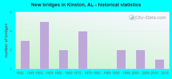
- New bridges - historical statistics
- 31940-1949
- 51950-1959
- 21960-1969
- 41970-1979
- 21990-1999
- 22000-2009
- 12010-2019


- Bridge Condition - Deck
- 9.1%Excellent
- 18.2%Very good
- 9.1%Good
- 54.5%Satisfactory
- 9.1%Fair

- Bridge Condition - Superstructure
- 27.3%Very good
- 45.5%Good
- 27.3%Satisfactory

- Bridge Condition - Substructure
- 9.1%Excellent
- 18.2%Very good
- 9.1%Good
- 63.6%Satisfactory

- Bridge Condition - Channel
- 5.3%Excellent
- 15.8%Very good
- 47.4%Good
- 21.1%Satisfactory
- 5.3%Fair
- 5.3%Poor

- Bridge Condition - Culverts
- 12.5%Very good
- 62.5%Good
- 25.0%Satisfactory
Find on map >> Show street view
Structure Number: 3061, Location: .3 MI S JCT AL 174 W (Lat: 33.682683, Lng: -86.398600), Route carried "on" structure: US 411, Year Built: 1947, Status: Open, Structure Length: 1.04m (3.41ft), Average Daily Traffic: 9,190 (year 2021), Truck Traffic: 15%, Average Future Daily Traffic: 12,184 (year 2041), Design Load: H 15, Features Intersected: BRANCH
Minimum Vertical Clearance: 30+ m (98+ ft), Kilometerpoint: 294.063, Lanes on structure: 2, Owner: State Highway Agency, Approaching Roadway Width: 7.3m (24.0ft), Material/Design: Steel, Design/Construction: Culvert, Number Of Spans In Main Unit: 3, Length of Maximum Span: 3.0m (9.8ft)
Condition: Channel: Satisfactory, Culverts: Satisfactory, Operating Rating: 32.8 metric tons, Method Used To Determine Operating Rating: Load Factor (LF), Inventory Rating: 26.0 metric tons, Method Used To Determine Inventory Rating: Load Factor (LF), Structural Evaluation: Equal to present minimum criteria, Waterway Adequacy: Somewhat better than minimum adequacy, Approach Roadway Alignment: Equal to present desirable criteria, Length Of Structure Improvement: 1.71m (5.61ft), Designated Inspection Frequency: Every 24 months, Inspection Date: January 2021, Bridge Improvement Cost: $316,000, Roadway Improvement Cost: $32,000, Total Project Cost: $348,000 ( Estimate for 2022)
Find on map >> Show street view
Structure Number: 3902, Location: .5 MI.N.COFFEE CO.6 (Lat: 31.225533, Lng: -86.161000), Route carried "on" structure: State highway 189, Year Built: 1950, Status: Open, Structure Length: 4.27m (14.01ft), Average Daily Traffic: 1,010 (year 2013), Truck Traffic: 10%, Average Future Daily Traffic: 1,344 (year 2033), Design Load: H 15, Features Intersected: CRIPPLE CREEK
Minimum Vertical Clearance: 30+ m (98+ ft), Kilometerpoint: 1.719, Lanes on structure: 2, Owner: State Highway Agency, Approaching Roadway Width: 9.8m (32.2ft), Material/Design: Steel, Design/Construction: Stringer/Multi-beam, Number Of Spans In Main Unit: 5, Length of Maximum Span: 8.5m (27.9ft), Curb or Sidewalk Widths: Left: 0.2m (0.7ft), Right: 0.2m (0.7ft), Curb-To-Curb Width: 6.6m (21.7ft), Out-to-Out Width: 7.1m (23.3ft)
Condition: Deck: Satisfactory, Superstructure: Good, Substructure: Satisfactory, Channel: Satisfactory, Operating Rating: 62.5 metric tons, Method Used To Determine Operating Rating: Load Testing, Inventory Rating: 41.6 metric tons, Method Used To Determine Inventory Rating: Load Testing, Structural Evaluation: Equal to present minimum criteria, Deck Geometry: High priority of replacement, Waterway Adequacy: Equal to present desirable criteria, Approach Roadway Alignment: Equal to present desirable criteria, Length Of Structure Improvement: 5.24m (17.19ft), Designated Inspection Frequency: Every 24 months, Inspection Date: May 2021, Bridge Improvement Cost: $827,000, Roadway Improvement Cost: $83,000, Total Project Cost: $910,000 ( Estimate for 2022), Deck Structure Type: Concrete Cast-file-Place
Find on map >> Show street view
Structure Number: 5463, Location: .7 MILE WEST OF KINSTON (Lat: 31.214422, Lng: -86.181058), Route carried "on" structure: County highway 479, Year Built: 1956, Status: Posted for load, Structure Length: 6.22m (20.41ft), Average Daily Traffic: 514 (year 2020), Truck Traffic: 10%, Average Future Daily Traffic: 650 (year 2040), Design Load: H 15, Features Intersected: FLAT CREEK
Minimum Vertical Clearance: 30+ m (98+ ft), Kilometerpoint: 0.010, Lanes on structure: 2, Owner: County Highway Agency, Approaching Roadway Width: 8.5m (27.9ft), Material/Design: Concrete, Design/Construction: Tee Beam, Number Of Spans In Main Unit: 6, Length of Maximum Span: 10.4m (34.1ft), Curb-To-Curb Width: 6.7m (22.0ft), Out-to-Out Width: 7.3m (24.0ft)
Condition: Deck: Satisfactory, Superstructure: Satisfactory, Substructure: Satisfactory, Channel: Good, Operating Rating: 35.7 metric tons, Method Used To Determine Operating Rating: Load Factor (LF), Inventory Rating: 21.5 metric tons, Method Used To Determine Inventory Rating: Load Factor (LF), Structural Evaluation: Somewhat better than minimum adequacy, Deck Geometry: Meets minimum limits, Waterway Adequacy: Better than present minimum criteria, Approach Roadway Alignment: Better than present minimum criteria, Bridge Posting: Required (Relationship of Operating Rating to Maximum Legal Load: 0.1 - 9.9% below), Length Of Structure Improvement: 7.26m (23.82ft), Designated Inspection Frequency: Every 24 months, Other Special Inspection Frequency: Every 12 months, Inspection Date: May 2020, Other Special Inspection Date: May 2021, Bridge Improvement Cost: $1,195,000, Roadway Improvement Cost: $120,000, Total Project Cost: $1,315,000 ( Estimate for 2022), Deck Structure Type: Concrete Cast-file-Place
Find on map >> Show street view
Structure Number: 5797, Location: 2.7 MILE SOUTHEAST KINSTO (Lat: 31.211336, Lng: -86.147411), Route carried "on" structure: County highway 473, Year Built: 1957, Status: Posted for load, Structure Length: 5.18m (16.99ft), Average Daily Traffic: 200 (year 2020), Truck Traffic: 5%, Average Future Daily Traffic: 350 (year 2040), Design Load: H 15, Features Intersected: CRIPPLE CREEK
Minimum Vertical Clearance: 30+ m (98+ ft), Kilometerpoint: 0.010, Lanes on structure: 2, Owner: County Highway Agency, Approaching Roadway Width: 8.5m (27.9ft), Material/Design: Concrete, Design/Construction: Tee Beam, Number Of Spans In Main Unit: 5, Length of Maximum Span: 10.4m (34.1ft), Curb-To-Curb Width: 7.3m (24.0ft), Out-to-Out Width: 8.2m (26.9ft)
Condition: Deck: Satisfactory, Superstructure: Good, Substructure: Satisfactory, Channel: Good, Operating Rating: 34.3 metric tons, Method Used To Determine Operating Rating: Load Factor (LF), Inventory Rating: 20.6 metric tons, Method Used To Determine Inventory Rating: Load Factor (LF), Structural Evaluation: Somewhat better than minimum adequacy, Deck Geometry: Somewhat better than minimum adequacy, Waterway Adequacy: Equal to present minimum criteria, Approach Roadway Alignment: Somewhat better than minimum adequacy, Bridge Posting: Required (Relationship of Operating Rating to Maximum Legal Load: 10.0 - 19.9% below), Length Of Structure Improvement: 6.20m (20.34ft), Designated Inspection Frequency: Every 24 months, Other Special Inspection Frequency: Every 12 months, Inspection Date: May 2020, Other Special Inspection Date: May 2021, Bridge Improvement Cost: $1,106,000, Roadway Improvement Cost: $111,000, Total Project Cost: $1,217,000 ( Estimate for 2022), Deck Structure Type: Concrete Cast-file-Place
Find on map >> Show street view
Structure Number: 5807, Location: 2.3 MILE NE OF KINSTON (Lat: 31.232614, Lng: -86.140528), Route carried "on" structure: County highway 474, Year Built: 1957, Status: Posted for load, Structure Length: 20.18m (66.21ft), Average Daily Traffic: 400 (year 2020), Truck Traffic: 5%, Average Future Daily Traffic: 400 (year 2040), Design Load: H 15, Features Intersected: PEA RIVER
Minimum Vertical Clearance: 30+ m (98+ ft), Kilometerpoint: 0.010, Lanes on structure: 2, Owner: County Highway Agency, Approaching Roadway Width: 8.5m (27.9ft), Material/Design: Concrete continuous, Design/Construction: Tee Beam, Number Of Spans In Main Unit: 3, Number Of Approach Spans: 12, Length of Maximum Span: 30.5m (100.1ft), Curb-To-Curb Width: 7.3m (24.0ft), Out-to-Out Width: 8.2m (26.9ft)
Condition: Deck: Satisfactory, Superstructure: Satisfactory, Substructure: Satisfactory, Channel: Good, Operating Rating: 34.3 metric tons, Method Used To Determine Operating Rating: Load Factor (LF), Inventory Rating: 20.6 metric tons, Method Used To Determine Inventory Rating: Load Factor (LF), Structural Evaluation: Somewhat better than minimum adequacy, Deck Geometry: Somewhat better than minimum adequacy, Waterway Adequacy: Better than present minimum criteria, Approach Roadway Alignment: Equal to present minimum criteria, Bridge Posting: Required (Relationship of Operating Rating to Maximum Legal Load: 10.0 - 19.9% below), Length Of Structure Improvement: 20.18m (66.21ft), Designated Inspection Frequency: Every 24 months, Underwater Inspection Frequency: Every 48 months, Other Special Inspection Frequency: Every 12 months, Inspection Date: May 2020, Underwater Inspection Date: September 2020, Other Special Inspection Date: May 2021, Bridge Improvement Cost: $3,598,000, Roadway Improvement Cost: $360,000, Total Project Cost: $3,958,000 ( Estimate for 2022), Deck Structure Type: Concrete Cast-file-Place
Find on map >> Show street view
Structure Number: 6187, Location: ALBERTON (Lat: 31.278739, Lng: -86.126019), Route carried "on" structure: County highway 427, Year Built: 1958, Status: Posted for load, Structure Length: 5.18m (16.99ft), Average Daily Traffic: 432 (year 2020), Truck Traffic: 5%, Average Future Daily Traffic: 475 (year 2040), Design Load: H 15, Features Intersected: PAGES CREEK
Minimum Vertical Clearance: 30+ m (98+ ft), Kilometerpoint: 0.010, Lanes on structure: 2, Owner: County Highway Agency, Approaching Roadway Width: 8.5m (27.9ft), Material/Design: Concrete, Design/Construction: Tee Beam, Number Of Spans In Main Unit: 5, Length of Maximum Span: 10.4m (34.1ft), Curb-To-Curb Width: 7.3m (24.0ft), Out-to-Out Width: 9.0m (29.5ft)
Condition: Deck: Satisfactory, Superstructure: Good, Substructure: Good, Channel: Good, Operating Rating: 34.3 metric tons, Method Used To Determine Operating Rating: Load Factor (LF), Inventory Rating: 20.6 metric tons, Method Used To Determine Inventory Rating: Load Factor (LF), Structural Evaluation: Somewhat better than minimum adequacy, Deck Geometry: Meets minimum limits, Waterway Adequacy: Better than present minimum criteria, Approach Roadway Alignment: Better than present minimum criteria, Bridge Posting: Required (Relationship of Operating Rating to Maximum Legal Load: 10.0 - 19.9% below), Length Of Structure Improvement: 6.20m (20.34ft), Designated Inspection Frequency: Every 24 months, Other Special Inspection Frequency: Every 12 months, Inspection Date: May 2020, Other Special Inspection Date: May 2021, Bridge Improvement Cost: $1,233,000, Roadway Improvement Cost: $123,000, Total Project Cost: $1,356,000 ( Estimate for 2022), Deck Structure Type: Concrete Cast-file-Place
Find on map >> Show street view
Structure Number: 7925, Location: 1.8 MILE NE OF KINSTON (Lat: 31.231100, Lng: -86.146458), Route carried "on" structure: County highway 474, Year Built: 1963, Status: Open, Structure Length: 0.73m (2.40ft), Average Daily Traffic: 425 (year 2020), Truck Traffic: 5%, Average Future Daily Traffic: 550 (year 2040), Design Load: H 10, Features Intersected: CANEY BRANCH
Minimum Vertical Clearance: 30+ m (98+ ft), Kilometerpoint: 0.010, Lanes on structure: 2, Owner: County Highway Agency, Approaching Roadway Width: 8.5m (27.9ft), Material/Design: Concrete, Design/Construction: Culvert, Number Of Spans In Main Unit: 2, Length of Maximum Span: 3.7m (12.1ft)
Condition: Channel: Fair, Culverts: Satisfactory, Operating Rating: 88.9 metric tons, Method Used To Determine Operating Rating: Load Factor (LF), Inventory Rating: 88.9 metric tons, Method Used To Determine Inventory Rating: Load Factor (LF), Structural Evaluation: Equal to present minimum criteria, Waterway Adequacy: Better than present minimum criteria, Approach Roadway Alignment: Better than present minimum criteria, Length Of Structure Improvement: 1.38m (4.53ft), Designated Inspection Frequency: Every 24 months, Inspection Date: July 2020, Bridge Improvement Cost: $445,000, Roadway Improvement Cost: $45,000, Total Project Cost: $490,000 ( Estimate for 2022)
Find on map >> Show street view
Structure Number: 104, Location: 2 MI. S. OF BEULAH (Lat: 31.198669, Lng: -86.225261), Route carried "on" structure: County highway 91, Year Built: 1970, Status: Open, Structure Length: 2.13m (6.99ft), Average Daily Traffic: 290 (year 1994), Truck Traffic: 5%, Average Future Daily Traffic: 373 (year 2030), Design Load: H 15, Features Intersected: FLAT CREEK
Minimum Vertical Clearance: 30+ m (98+ ft), Kilometerpoint: 0.000, Lanes on structure: 2, Owner: County Highway Agency, Approaching Roadway Width: 10.5m (34.4ft), Material/Design: Concrete, Design/Construction: Culvert, Number Of Spans In Main Unit: 5, Length of Maximum Span: 4.3m (14.1ft)
Condition: Channel: Good, Culverts: Good, Operating Rating: 49.8 metric tons, Method Used To Determine Operating Rating: Load Factor (LF), Inventory Rating: 29.8 metric tons, Method Used To Determine Inventory Rating: Load Factor (LF), Structural Evaluation: Better than present minimum criteria, Waterway Adequacy: Better than present minimum criteria, Approach Roadway Alignment: Better than present minimum criteria, Length Of Structure Improvement: 2.92m (9.58ft), Designated Inspection Frequency: Every 24 months, Inspection Date: April 2020, Bridge Improvement Cost: $607,000, Roadway Improvement Cost: $61,000, Total Project Cost: $668,000 ( Estimate for 2022), Wearing Surface/Protective System: Wearing Surface: Bituminous
Find on map >> Show street view
Structure Number: 1114, Location: 3 MILE N OF KINSTON (Lat: 31.249450, Lng: -86.180981), Route carried "on" structure: County highway 464, Year Built: 1974, Status: Open, Structure Length: 1.62m (5.31ft), Average Daily Traffic: 20 (year 2020), Average Future Daily Traffic: 50 (year 2040), Design Load: H 10, Features Intersected: CRIPPLE CREEK
Minimum Vertical Clearance: 30+ m (98+ ft), Kilometerpoint: 0.010, Lanes on structure: 2, Owner: County Highway Agency, Approaching Roadway Width: 8.5m (27.9ft), Material/Design: Concrete, Design/Construction: Culvert, Number Of Spans In Main Unit: 5, Length of Maximum Span: 3.0m (9.8ft), Curb-To-Curb Width: 11.6m (38.1ft), Out-to-Out Width: 12.2m (40.0ft)
Condition: Channel: Good, Culverts: Good, Operating Rating: 51.9 metric tons, Method Used To Determine Operating Rating: Load Factor (LF), Inventory Rating: 31.1 metric tons, Method Used To Determine Inventory Rating: Load Factor (LF), Structural Evaluation: Better than present minimum criteria, Deck Geometry: Superior to present desirable criteria, Waterway Adequacy: Better than present minimum criteria, Approach Roadway Alignment: Better than present minimum criteria, Length Of Structure Improvement: 2.30m (7.55ft), Designated Inspection Frequency: Every 24 months, Inspection Date: July 2020, Bridge Improvement Cost: $532,000, Roadway Improvement Cost: $53,000, Total Project Cost: $585,000 ( Estimate for 2022)
Find on map >> Show street view
Structure Number: 11141, Location: 1.8 MI S OF RHOADES (Lat: 31.258878, Lng: -86.144350), Route carried "on" structure: County highway 467, Year Built: 1974, Status: Open, Structure Length: 0.67m (2.20ft), Average Daily Traffic: 40 (year 2020), Average Future Daily Traffic: 75 (year 2040), Design Load: H 10, Features Intersected: TEEL CREEK
Minimum Vertical Clearance: 30+ m (98+ ft), Kilometerpoint: 0.010, Lanes on structure: 2, Owner: County Highway Agency, Approaching Roadway Width: 8.5m (27.9ft), Material/Design: Concrete, Design/Construction: Culvert, Number Of Spans In Main Unit: 2, Length of Maximum Span: 3.0m (9.8ft)
Condition: Channel: Good, Culverts: Good, Operating Rating: 68.2 metric tons, Method Used To Determine Operating Rating: Load Factor (LF), Inventory Rating: 40.9 metric tons, Method Used To Determine Inventory Rating: Load Factor (LF), Structural Evaluation: Better than present minimum criteria, Waterway Adequacy: Better than present minimum criteria, Approach Roadway Alignment: Equal to present minimum criteria, Length Of Structure Improvement: 1.30m (4.27ft), Designated Inspection Frequency: Every 24 months, Inspection Date: July 2020, Bridge Improvement Cost: $405,000, Roadway Improvement Cost: $41,000, Total Project Cost: $446,000 ( Estimate for 2022)
Find on map >> Show street view
Structure Number: 11142, Location: 2.7 MI N OF KINSTON (Lat: 31.239822, Lng: -86.173111), Route carried "on" structure: County highway 470, Year Built: 1974, Status: Open, Structure Length: 1.98m (6.50ft), Average Daily Traffic: 25 (year 2020), Average Future Daily Traffic: 50 (year 2040), Design Load: H 10, Features Intersected: CRIPPLE CREEK
Minimum Vertical Clearance: 30+ m (98+ ft), Kilometerpoint: 0.010, Lanes on structure: 2, Owner: County Highway Agency, Approaching Roadway Width: 8.5m (27.9ft), Material/Design: Concrete, Design/Construction: Culvert, Number Of Spans In Main Unit: 5, Length of Maximum Span: 3.7m (12.1ft)
Condition: Channel: Good, Culverts: Good, Operating Rating: 57.9 metric tons, Method Used To Determine Operating Rating: Load Factor (LF), Inventory Rating: 34.7 metric tons, Method Used To Determine Inventory Rating: Load Factor (LF), Structural Evaluation: Better than present minimum criteria, Waterway Adequacy: Better than present minimum criteria, Approach Roadway Alignment: Better than present minimum criteria, Length Of Structure Improvement: 2.73m (8.96ft), Designated Inspection Frequency: Every 24 months, Inspection Date: July 2020, Bridge Improvement Cost: $1,008,000, Roadway Improvement Cost: $101,000, Total Project Cost: $1,109,000 ( Estimate for 2022)
Find on map >> Show street view
Structure Number: 13758, Location: 3 MI SOUTH OF BEULAH CH. (Lat: 31.186131, Lng: -86.231478), Route carried "on" structure: County highway , Year Built: 1940, Year Reconstructed: 1986, Status: Closed, Structure Length: 0.98m (3.22ft), Average Daily Traffic: 70 (year 1994), Average Future Daily Traffic: 86 (year 2030), Features Intersected: FLAT CREEK, Facility Carried by Structure: COUNTY DIRT RD
Minimum Vertical Clearance: 99.00m (324.80ft), Kilometerpoint: 0.010, Lanes on structure: 1, Owner: County Highway Agency, Approaching Roadway Width: 5.5m (18.0ft), Material/Design: Wood or Timber, Design/Construction: Stringer/Multi-beam, Number Of Spans In Main Unit: 2, Length of Maximum Span: 4.9m (16.1ft), Curb-To-Curb Width: 4.9m (16.1ft), Out-to-Out Width: 4.9m (16.1ft)
Condition: Deck: Fair, Superstructure: Satisfactory, Substructure: Satisfactory, Channel: Satisfactory, Operating Rating: 16.2 metric tons, Method Used To Determine Operating Rating: Allowable Stress (AS), Inventory Rating: 11.8 metric tons, Method Used To Determine Inventory Rating: Allowable Stress (AS), Structural Evaluation: Meets minimum limits, Deck Geometry: High priority of corrective action, Waterway Adequacy: Better than present minimum criteria, Approach Roadway Alignment: Better than present minimum criteria, Bridge Posting: Required (Relationship of Operating Rating to Maximum Legal Load: > 39.9% below), Length Of Structure Improvement: 1.65m (5.41ft), Designated Inspection Frequency: Every 24 months, Other Special Inspection Frequency: Every 12 months, Inspection Date: April 2018, Other Special Inspection Date: April 2018, Bridge Improvement Cost: $181,000, Roadway Improvement Cost: $18,000, Total Project Cost: $199,000 ( Estimate for 2022), Deck Structure Type: Wood or Timber, Wearing Surface/Protective System: Wearing Surface: Wood or Timber
Find on map >> Show street view
Structure Number: 13769, Location: 6 1/2 MI SE OF OPP (Lat: 31.196842, Lng: -86.210100), Route carried "on" structure: County highway , Year Built: 1948, Year Reconstructed: 1986, Status: Posted for load, Structure Length: 0.91m (2.99ft), Average Daily Traffic: 150 (year 1994), Truck Traffic: 1%, Average Future Daily Traffic: 200 (year 2030), Features Intersected: NO NAME BRANCH, Facility Carried by Structure: COUNTY DIRT RD
Minimum Vertical Clearance: 30+ m (98+ ft), Kilometerpoint: 0.010, Lanes on structure: 1, Owner: County Highway Agency, Approaching Roadway Width: 7.3m (24.0ft), Material/Design: Wood or Timber, Design/Construction: Stringer/Multi-beam, Number Of Spans In Main Unit: 2, Length of Maximum Span: 4.6m (15.1ft), Curb-To-Curb Width: 4.9m (16.1ft), Out-to-Out Width: 4.9m (16.1ft)
Condition: Deck: Satisfactory, Superstructure: Good, Substructure: Satisfactory, Channel: Satisfactory, Operating Rating: 15.7 metric tons, Method Used To Determine Operating Rating: Allowable Stress (AS), Inventory Rating: 11.5 metric tons, Method Used To Determine Inventory Rating: Allowable Stress (AS), Structural Evaluation: Meets minimum limits, Deck Geometry: High priority of replacement, Waterway Adequacy: Better than present minimum criteria, Approach Roadway Alignment: Better than present minimum criteria, Bridge Posting: Required (Relationship of Operating Rating to Maximum Legal Load: > 39.9% below), Length Of Structure Improvement: 1.59m (5.22ft), Designated Inspection Frequency: Every 24 months, Other Special Inspection Frequency: Every 12 months, Inspection Date: September 2020, Other Special Inspection Date: September 2021, Bridge Improvement Cost: $174,000, Roadway Improvement Cost: $17,000, Total Project Cost: $191,000 ( Estimate for 2022), Deck Structure Type: Wood or Timber, Wearing Surface/Protective System: Wearing Surface: Wood or Timber
Find on map >> Show street view
Structure Number: 1566, Location: 4.5 MI. E. ONYCHA (Lat: 31.230633, Lng: -86.203436), Route carried "on" structure: County highway 40, Year Built: 1961, Status: Open, Structure Length: 1.27m (4.17ft), Average Daily Traffic: 200 (year 1994), Truck Traffic: 5%, Average Future Daily Traffic: 287 (year 2030), Design Load: H 15, Features Intersected: SHOTBAG CREEK
Minimum Vertical Clearance: 30+ m (98+ ft), Kilometerpoint: 0.010, Lanes on structure: 2, Owner: County Highway Agency, Approaching Roadway Width: 9.1m (29.9ft), Material/Design: Concrete, Design/Construction: Culvert, Number Of Spans In Main Unit: 4, Length of Maximum Span: 3.0m (9.8ft)
Condition: Channel: Poor, Culverts: Good, Operating Rating: 42.7 metric tons, Method Used To Determine Operating Rating: Load Factor (LF), Inventory Rating: 26.0 metric tons, Method Used To Determine Inventory Rating: Load Factor (LF), Structural Evaluation: Equal to present minimum criteria, Waterway Adequacy: Better than present minimum criteria, Approach Roadway Alignment: Equal to present desirable criteria, Length Of Structure Improvement: 1.95m (6.40ft), Designated Inspection Frequency: Every 24 months, Inspection Date: January 2021, Bridge Improvement Cost: $360,000, Roadway Improvement Cost: $36,000, Total Project Cost: $396,000 ( Estimate for 2022), Wearing Surface/Protective System: Wearing Surface: Bituminous
Find on map >> Show street view
Structure Number: 17345, Location: 7 MILES N.W. OF SAMSON (Lat: 31.180192, Lng: -86.134983), Route carried "on" structure: County highway , Year Built: 1997, Status: Posted for load, Structure Length: 1.55m (5.09ft), Average Daily Traffic: 77 (year 2020), Average Future Daily Traffic: 77 (year 2040), Design Load: HS 20, Features Intersected: BEAR BRANCH, Facility Carried by Structure: BEAR BR. RD.
Minimum Vertical Clearance: 30+ m (98+ ft), Kilometerpoint: 0.000, Lanes on structure: 1, Owner: County Highway Agency, Approaching Roadway Width: 6.1m (20.0ft), Material/Design: Wood or Timber, Design/Construction: Stringer/Multi-beam, Number Of Spans In Main Unit: 3, Length of Maximum Span: 5.5m (18.0ft), Curb-To-Curb Width: 4.6m (15.1ft), Out-to-Out Width: 5.0m (16.4ft)
Condition: Deck: Good, Superstructure: Good, Substructure: Satisfactory, Channel: Good, Operating Rating: 31.8 metric tons, Method Used To Determine Operating Rating: Allowable Stress (AS), Inventory Rating: 23.5 metric tons, Method Used To Determine Inventory Rating: Allowable Stress (AS), Structural Evaluation: Equal to present minimum criteria, Deck Geometry: Better than present minimum criteria, Waterway Adequacy: Better than present minimum criteria, Approach Roadway Alignment: Somewhat better than minimum adequacy, Bridge Posting: Required (Relationship of Operating Rating to Maximum Legal Load: 30.0 - 39.9% below), Length Of Structure Improvement: 2.23m (7.32ft), Designated Inspection Frequency: Every 24 months, Other Special Inspection Frequency: Every 12 months, Inspection Date: May 2020, Other Special Inspection Date: May 2021, Bridge Improvement Cost: $245,000, Roadway Improvement Cost: $25,000, Total Project Cost: $270,000 ( Estimate for 2022), Deck Structure Type: Wood or Timber, Wearing Surface/Protective System: Wearing Surface: Wood or Timber
Find on map >> Show street view
Structure Number: 1746, Location: .8 MI N PERRY STORE (Lat: 31.292478, Lng: -86.155997), Route carried "on" structure: County highway 442, Year Built: 1998, Status: Open, Structure Length: 1.60m (5.25ft), Average Daily Traffic: 98 (year 2020), Average Future Daily Traffic: 150 (year 2040), Design Load: H 10, Features Intersected: STANLEY MILL CREEK
Minimum Vertical Clearance: 30+ m (98+ ft), Kilometerpoint: 0.000, Lanes on structure: 2, Owner: County Highway Agency, Approaching Roadway Width: 8.5m (27.9ft), Material/Design: Concrete, Design/Construction: Culvert, Number Of Spans In Main Unit: 4, Length of Maximum Span: 4.0m (13.1ft), Out-to-Out Width: 15.8m (51.8ft)
Condition: Channel: Very good, Culverts: Very good, Operating Rating: 46.6 metric tons, Method Used To Determine Operating Rating: Load Factor (LF), Inventory Rating: 27.9 metric tons, Method Used To Determine Inventory Rating: Load Factor (LF), Structural Evaluation: Better than present minimum criteria, Waterway Adequacy: Better than present minimum criteria, Approach Roadway Alignment: Equal to present desirable criteria, Length Of Structure Improvement: 2.29m (7.51ft), Designated Inspection Frequency: Every 24 months, Inspection Date: July 2020, Bridge Improvement Cost: $686,000, Roadway Improvement Cost: $69,000, Total Project Cost: $755,000 ( Estimate for 2022)
Find on map >> Show street view
Structure Number: 17772, Location: 3 MI. E. SR. 189 (Lat: 31.274650, Lng: -86.116067), Route carried "on" structure: State highway 134, Year Built: 2003, Status: Open, Structure Length: 12.34m (40.49ft), Average Daily Traffic: 3,940 (year 2013), Truck Traffic: 10%, Average Future Daily Traffic: 5,674 (year 2033), Design Load: HS 20, Features Intersected: PEA RIVER
Minimum Vertical Clearance: 30+ m (98+ ft), Kilometerpoint: 13.459, Lanes on structure: 2, Owner: State Highway Agency, Approaching Roadway Width: 12.2m (40.0ft), Material/Design: Prestressed concrete, Design/Construction: Stringer/Multi-beam, Number Of Spans In Main Unit: 3, Length of Maximum Span: 41.1m (134.8ft), Curb-To-Curb Width: 13.4m (44.0ft), Out-to-Out Width: 14.1m (46.3ft)
Condition: Deck: Very good, Superstructure: Very good, Substructure: Very good, Channel: Very good, Operating Rating: 85.8 metric tons, Method Used To Determine Operating Rating: Load Factor (LF), Inventory Rating: 46.8 metric tons, Method Used To Determine Inventory Rating: Load Factor (LF), Structural Evaluation: Equal to present desirable criteria, Deck Geometry: Better than present minimum criteria, Waterway Adequacy: Equal to present desirable criteria, Approach Roadway Alignment: Equal to present desirable criteria, Length Of Structure Improvement: 13.19m (43.27ft), Designated Inspection Frequency: Every 24 months, Inspection Date: May 2021, Bridge Improvement Cost: $4,160,000, Roadway Improvement Cost: $416,000, Total Project Cost: $4,576,000 ( Estimate for 2022), Deck Structure Type: Concrete Cast-file-Place
Find on map >> Show street view
Structure Number: 17834, Location: 3 MI.E.OF SR.189 (Lat: 31.275333, Lng: -86.119667), Route carried "on" structure: State highway 134, Year Built: 2003, Status: Open, Structure Length: 15.09m (49.51ft), Average Daily Traffic: 3,940 (year 2013), Truck Traffic: 10%, Average Future Daily Traffic: 5,674 (year 2033), Design Load: HS 20, Features Intersected: PEA RIVER RELIEF
Minimum Vertical Clearance: 30+ m (98+ ft), Kilometerpoint: 13.069, Lanes on structure: 2, Owner: State Highway Agency, Approaching Roadway Width: 12.2m (40.0ft), Material/Design: Prestressed concrete, Design/Construction: Stringer/Multi-beam, Number Of Spans In Main Unit: 11, Length of Maximum Span: 13.7m (44.9ft), Curb-To-Curb Width: 13.3m (43.6ft), Out-to-Out Width: 14.1m (46.3ft)
Condition: Deck: Very good, Superstructure: Very good, Substructure: Very good, Channel: Very good, Operating Rating: 62.4 metric tons, Method Used To Determine Operating Rating: Load Factor (LF), Inventory Rating: 28.6 metric tons, Method Used To Determine Inventory Rating: Load Factor (LF), Structural Evaluation: Better than present minimum criteria, Deck Geometry: Equal to present minimum criteria, Waterway Adequacy: Equal to present desirable criteria, Approach Roadway Alignment: Equal to present desirable criteria, Length Of Structure Improvement: 15.86m (52.03ft), Designated Inspection Frequency: Every 24 months, Inspection Date: April 2021, Bridge Improvement Cost: $5,003,000, Roadway Improvement Cost: $500,000, Total Project Cost: $5,503,000 ( Estimate for 2022), Deck Structure Type: Concrete Cast-file-Place
Find on map >> Show street view
Structure Number: 20745, Location: 2 miles south of Kinston (Lat: 31.179781, Lng: -86.159083), Route carried "on" structure: County highway , Year Built: 2017, Status: Open, Structure Length: 1.22m (4.00ft), Average Daily Traffic: 9 (year 2020), Average Future Daily Traffic: 13 (year 2040), Design Load: HS 20, Features Intersected: Unnamed Trib to Flat Cr, Facility Carried by Structure: Emmett Road (CR74)
Minimum Vertical Clearance: 30+ m (98+ ft), Kilometerpoint: 0.010, Lanes on structure: 2, Owner: County Highway Agency, Approaching Roadway Width: 7.9m (25.9ft), Material/Design: Concrete, Design/Construction: Channel Beam, Number Of Spans In Main Unit: 1, Length of Maximum Span: 12.2m (40.0ft), Curb-To-Curb Width: 7.5m (24.6ft), Out-to-Out Width: 8.2m (26.9ft)
Condition: Deck: Excellent, Superstructure: Very good, Substructure: Excellent, Channel: Excellent, Operating Rating: 88.9 metric tons, Method Used To Determine Operating Rating: Load Factor (LF), Inventory Rating: 54.4 metric tons, Method Used To Determine Inventory Rating: Load Factor (LF), Structural Evaluation: Equal to present desirable criteria, Deck Geometry: Equal to present minimum criteria, Waterway Adequacy: Superior to present desirable criteria, Approach Roadway Alignment: Superior to present desirable criteria, Length Of Structure Improvement: 1.89m (6.20ft), Designated Inspection Frequency: Every 24 months, Inspection Date: July 2020, Bridge Improvement Cost: $350,000, Roadway Improvement Cost: $35,000, Total Project Cost: $385,000 ( Estimate for 2022), Deck Structure Type: Concrete Precast Panels