Bridge Statistics for Kirby, Texas (TX)
Condition, Traffic, Stress, Structural Evaluation, Project Costs
- National Bridge Inventory (NBI) Statistics
- 12Number of bridges
- 115ft / 35.0mTotal length
- 76,775Total average daily traffic
- 1,084Total average daily truck traffic
- 108,720Total future (year 2033) average daily traffic
- National Bridge Inventory (NBI) Registered Bridges for Kirby
- No street view available for this location
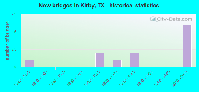
- New bridges - historical statistics
- 11920-1929
- 21960-1969
- 11970-1979
- 21980-1989
- 62010-2019
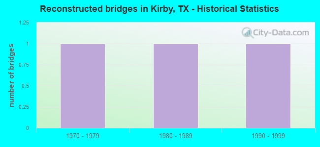
- Reconstructed bridges - Historical Statistics
- 11970-1979
- 11980-1989
- 11990-1999
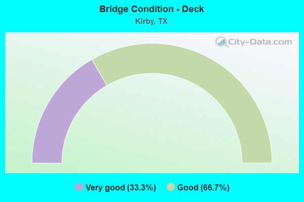
- Bridge Condition - Deck
- 33.3%Very good
- 66.7%Good
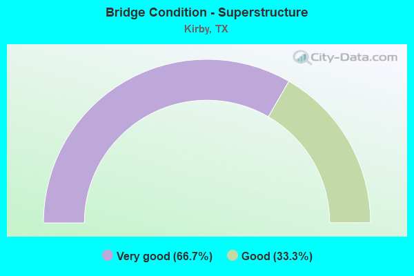
- Bridge Condition - Superstructure
- 66.7%Very good
- 33.3%Good

- Bridge Condition - Substructure
- 66.7%Very good
- 33.3%Good
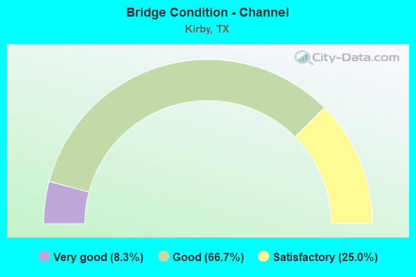
- Bridge Condition - Channel
- 8.3%Very good
- 66.7%Good
- 25.0%Satisfactory

- Bridge Condition - Culverts
- 66.7%Good
- 33.3%Satisfactory
Find on map >> Show street view
Structure Number: 15015000250917, Location: 1.10 MI NE OF IH 410 (Lat: 29.469247, Lng: -98.389703), Route carried "on" structure: State highway 78, Year Built: 1966, Year Reconstructed: 1998, Status: Open, Structure Length: 1.43m (4.69ft), Average Daily Traffic: 23,248 (year 2020), Truck Traffic: 2%, Average Future Daily Traffic: 36,580 (year 2033), Design Load: HS 20, Features Intersected: DRAW
Minimum Vertical Clearance: 30+ m (98+ ft), Kilometerpoint: 17.790, Lanes on structure: 5, Owner: State Highway Agency, Approaching Roadway Width: 25.0m (82.0ft), Skew: 3 degrees, Material/Design: Concrete, Design/Construction: Culvert, Number Of Spans In Main Unit: 6, Length of Maximum Span: 1.8m (5.9ft)
Condition: Channel: Good, Culverts: Good, Operating Rating: 39.9 metric tons, Method Used To Determine Operating Rating: Load Factor (LF), Inventory Rating: 23.6 metric tons, Method Used To Determine Inventory Rating: Load Factor (LF), Structural Evaluation: Somewhat better than minimum adequacy, Waterway Adequacy: Equal to present minimum criteria, Approach Roadway Alignment: Equal to present desirable criteria, Designated Inspection Frequency: Every 24 months, Inspection Date: June 2020
Find on map >> Show street view
Structure Number: 150150002509171, Location: 1.8 MI EAST OF IH 410 (Lat: 29.474989, Lng: -98.378708), Route carried "on" structure: State highway 78, Year Built: 1966, Year Reconstructed: 1994, Status: Open, Structure Length: 1.65m (5.41ft), Average Daily Traffic: 24,125 (year 2020), Truck Traffic: 2%, Average Future Daily Traffic: 29,540 (year 2033), Design Load: HS 20, Features Intersected: ROSILLO CR
Minimum Vertical Clearance: 30+ m (98+ ft), Kilometerpoint: 19.030, Lanes on structure: 5, Owner: State Highway Agency, Approaching Roadway Width: 25.0m (82.0ft), Material/Design: Concrete, Design/Construction: Culvert, Number Of Spans In Main Unit: 5, Length of Maximum Span: 3.0m (9.8ft)
Condition: Channel: Satisfactory, Culverts: Good, Operating Rating: 39.9 metric tons, Method Used To Determine Operating Rating: Load Factor (LF), Inventory Rating: 23.6 metric tons, Method Used To Determine Inventory Rating: Load Factor (LF), Structural Evaluation: Somewhat better than minimum adequacy, Waterway Adequacy: Superior to present desirable criteria, Approach Roadway Alignment: Equal to present desirable criteria, Designated Inspection Frequency: Every 24 months, Inspection Date: June 2020
Find on map >> Show street view
Structure Number: 150150B25585001, Location: 0.30 MI E OF ACKERMAN RD (Lat: 29.473281, Lng: -98.378067), Route carried "on" structure: City street , Year Built: 1925, Year Reconstructed: 1979, Status: Open, Structure Length: 1.19m (3.90ft), Average Daily Traffic: 2,918 (year 2020), Average Future Daily Traffic: 5,000 (year 2033), Design Load: H 15, Features Intersected: ROSILLO CREEK, Facility Carried by Structure: OLD SEGUIN RD
Minimum Vertical Clearance: 30+ m (98+ ft), Kilometerpoint: 0.483, Lanes on structure: 2, Owner: City or Municipal Highway Agency, Approaching Roadway Width: 8.5m (27.9ft), Material/Design: Concrete, Design/Construction: Culvert, Number Of Spans In Main Unit: 6, Length of Maximum Span: 1.8m (5.9ft), Curb-To-Curb Width: 12.3m (40.4ft), Out-to-Out Width: 12.9m (42.3ft)
Condition: Channel: Satisfactory, Culverts: Satisfactory, Operating Rating: 32.7 metric tons, Method Used To Determine Operating Rating: Field evaluation and documented engineering judgment, Inventory Rating: 24.5 metric tons, Method Used To Determine Inventory Rating: Field evaluation and documented engineering judgment, Structural Evaluation: Equal to present minimum criteria, Deck Geometry: Equal to present minimum criteria, Waterway Adequacy: Meets minimum limits, Approach Roadway Alignment: Equal to present desirable criteria, Designated Inspection Frequency: Every 24 months, Inspection Date: May 2021, Deck Structure Type: Concrete Cast-file-Place, Wearing Surface/Protective System: Wearing Surface: Bituminous
Find on map >> Show street view
Structure Number: 150150B33213001, Location: 0.05 MI S OF FM 78 (Lat: 29.473908, Lng: -98.375361), Route carried "on" structure: City street , Year Built: 1983, Status: Open, Structure Length: 3.23m (10.60ft), Average Daily Traffic: 5,443 (year 2020), Average Future Daily Traffic: 7,000 (year 2033), Features Intersected: RITTIMAN CREEK, Facility Carried by Structure: SUMMER FEST RD
Minimum Vertical Clearance: 30+ m (98+ ft), Kilometerpoint: 0.068, Lanes on structure: 2, Owner: City or Municipal Highway Agency, Approaching Roadway Width: 12.2m (40.0ft), Material/Design: Concrete, Design/Construction: Culvert, Number Of Spans In Main Unit: 10, Length of Maximum Span: 3.0m (9.8ft), Curb or Sidewalk Widths: Left: 1.1m (3.6ft), Right: 1.2m (3.9ft), Curb-To-Curb Width: 12.2m (40.0ft), Out-to-Out Width: 15.2m (49.9ft)
Condition: Channel: Satisfactory, Culverts: Satisfactory, Operating Rating: 32.7 metric tons, Method Used To Determine Operating Rating: Field evaluation and documented engineering judgment, Inventory Rating: 24.5 metric tons, Method Used To Determine Inventory Rating: Field evaluation and documented engineering judgment, Structural Evaluation: Equal to present minimum criteria, Deck Geometry: Somewhat better than minimum adequacy, Waterway Adequacy: Equal to present minimum criteria, Approach Roadway Alignment: Equal to present desirable criteria, Designated Inspection Frequency: Every 24 months, Inspection Date: May 2021, Deck Structure Type: Concrete Cast-file-Place, Wearing Surface/Protective System: Wearing Surface: Bituminous
Find on map >> Show street view
Structure Number: 150150H00045002, Location: 0.5 MI SW OF ACKERMAN (Lat: 29.467369, Lng: -98.389106), Route carried "on" structure: City street , Year Built: 2016, Status: Open, Structure Length: 2.13m (6.99ft), Average Daily Traffic: 4,170 (year 2013), Average Future Daily Traffic: 5,500 (year 2033), Design Load: HL 93, Features Intersected: ROSILLO CRK W TRIBUTARY, Facility Carried by Structure: OLD SEGUIN RD
Minimum Vertical Clearance: 30+ m (98+ ft), Kilometerpoint: 0.885, Lanes on structure: 2, Owner: City or Municipal Highway Agency, Approaching Roadway Width: 13.4m (44.0ft), Skew: 1 degrees, Material/Design: Prestressed concrete, Design/Construction: Box Beam or Girders - Multiple, Number Of Spans In Main Unit: 1, Length of Maximum Span: 21.3m (69.9ft), Curb or Sidewalk Widths: Left: 1.8m (5.9ft), Right: 1.8m (5.9ft), Curb-To-Curb Width: 13.4m (44.0ft), Out-to-Out Width: 17.7m (58.1ft)
Condition: Deck: Very good, Superstructure: Very good, Substructure: Very good, Channel: Very good, Operating Rating: 54.4 metric tons, Method Used To Determine Operating Rating: Assigned ratings based on Load and Resistance Factor Design (LRFD) reported in metric tons, Inventory Rating: 32.7 metric tons, Method Used To Determine Inventory Rating: Assigned ratings based on Load and Resistance Factor Design (LRFD) reported in metric tons, Structural Evaluation: Equal to present desirable criteria, Deck Geometry: Better than present minimum criteria, Waterway Adequacy: Superior to present desirable criteria, Approach Roadway Alignment: Equal to present desirable criteria, Designated Inspection Frequency: Every 24 months, Inspection Date: May 2021, Deck Structure Type: Concrete Cast-file-Place
Find on map >> Show street view
Structure Number: 150150H00080002, Location: 0.01 MI E OF AUTUMN (Lat: 29.465786, Lng: -98.388453), Route carried "on" structure: City street , Year Built: 2016, Status: Open, Structure Length: 3.23m (10.60ft), Average Daily Traffic: 241 (year 2020), Average Future Daily Traffic: 600 (year 2033), Design Load: HL 93, Features Intersected: ROSILLO CRK W TRIBUTARY, Facility Carried by Structure: STARFIRE ST
Minimum Vertical Clearance: 30+ m (98+ ft), Kilometerpoint: 0.418, Lanes on structure: 2, Owner: City or Municipal Highway Agency, Approaching Roadway Width: 9.1m (29.9ft), Skew: 2 degrees, Material/Design: Concrete, Design/Construction: Culvert, Number Of Spans In Main Unit: 10, Length of Maximum Span: 3.0m (9.8ft), Curb or Sidewalk Widths: Left: 1.8m (5.9ft), Right: 1.5m (4.9ft), Curb-To-Curb Width: 9.1m (29.9ft), Out-to-Out Width: 13.4m (44.0ft)
Condition: Channel: Good, Culverts: Good, Operating Rating: 54.4 metric tons, Method Used To Determine Operating Rating: Assigned ratings based on Load and Resistance Factor Design (LRFD) reported in metric tons, Inventory Rating: 32.7 metric tons, Method Used To Determine Inventory Rating: Assigned ratings based on Load and Resistance Factor Design (LRFD) reported in metric tons, Structural Evaluation: Better than present minimum criteria, Deck Geometry: Equal to present minimum criteria, Waterway Adequacy: Superior to present desirable criteria, Approach Roadway Alignment: Equal to present desirable criteria, Designated Inspection Frequency: Every 24 months, Inspection Date: May 2021, Deck Structure Type: Concrete Cast-file-Place
Find on map >> Show street view
Structure Number: 150150H00115001, Location: 0.64 MI S OF OLD SEGUIN (Lat: 29.460267, Lng: -98.384236), Route carried "on" structure: City street , Year Built: 2014, Status: Open, Structure Length: 3.47m (11.38ft), Average Daily Traffic: 660 (year 2013), Average Future Daily Traffic: 1,000 (year 2033), Design Load: HL 93, Features Intersected: ROSILLO CRK W TRIBUTARY, Facility Carried by Structure: KIRBY DR
Minimum Vertical Clearance: 30+ m (98+ ft), Kilometerpoint: 0.161, Lanes on structure: 2, Owner: City or Municipal Highway Agency, Approaching Roadway Width: 9.1m (29.9ft), Skew: 2 degrees, Material/Design: Concrete, Design/Construction: Culvert, Number Of Spans In Main Unit: 10, Length of Maximum Span: 3.0m (9.8ft), Curb or Sidewalk Widths: Left: 1.8m (5.9ft), Right: 1.8m (5.9ft), Curb-To-Curb Width: 9.1m (29.9ft), Out-to-Out Width: 13.4m (44.0ft)
Condition: Channel: Good, Culverts: Good, Operating Rating: 54.4 metric tons, Method Used To Determine Operating Rating: Assigned ratings based on Load and Resistance Factor Design (LRFD) reported in metric tons, Inventory Rating: 32.7 metric tons, Method Used To Determine Inventory Rating: No rating analysis performed, Structural Evaluation: Better than present minimum criteria, Deck Geometry: Equal to present minimum criteria, Waterway Adequacy: Better than present minimum criteria, Approach Roadway Alignment: Equal to present desirable criteria, Designated Inspection Frequency: Every 24 months, Inspection Date: May 2021, Deck Structure Type: Concrete Cast-file-Place, Wearing Surface/Protective System: Wearing Surface: Bituminous
Find on map >> Show street view
Structure Number: 150150H00125002, Location: 1.35 MI N OF IH 10 (Lat: 29.458358, Lng: -98.381189), Route carried "on" structure: City street , Year Built: 2014, Status: Open, Structure Length: 3.66m (12.01ft), Average Daily Traffic: 6,948 (year 2020), Truck Traffic: 2%, Average Future Daily Traffic: 10,000 (year 2033), Design Load: HL 93, Features Intersected: ROSILLO CRK W TRIBUTARY, Facility Carried by Structure: ACKERMAN RD
Minimum Vertical Clearance: 30+ m (98+ ft), Kilometerpoint: 1.770, Lanes on structure: 2, Owner: City or Municipal Highway Agency, Approaching Roadway Width: 16.8m (55.1ft), Material/Design: Prestressed concrete, Design/Construction: Box Beam or Girders - Multiple, Number Of Spans In Main Unit: 2, Length of Maximum Span: 18.3m (60.0ft), Curb or Sidewalk Widths: Left: 1.8m (5.9ft), Right: 1.8m (5.9ft), Curb-To-Curb Width: 16.8m (55.1ft), Out-to-Out Width: 21.0m (68.9ft)
Condition: Deck: Good, Superstructure: Very good, Substructure: Very good, Channel: Good, Operating Rating: 54.4 metric tons, Method Used To Determine Operating Rating: Assigned ratings based on Load and Resistance Factor Design (LRFD) reported in metric tons, Inventory Rating: 32.7 metric tons, Method Used To Determine Inventory Rating: No rating analysis performed, Structural Evaluation: Equal to present desirable criteria, Deck Geometry: Superior to present desirable criteria, Waterway Adequacy: Superior to present desirable criteria, Approach Roadway Alignment: Equal to present desirable criteria, Designated Inspection Frequency: Every 24 months, Inspection Date: May 2021, Deck Structure Type: Concrete Precast Panels
Find on map >> Show street view
Structure Number: 150150H00160001, Location: 0.04 MI E OF AUTUMN LN (Lat: 29.463111, Lng: -98.386311), Route carried "on" structure: City street , Year Built: 2016, Status: Open, Structure Length: 3.23m (10.60ft), Average Daily Traffic: 374 (year 2020), Average Future Daily Traffic: 1,000 (year 2033), Design Load: HL 93, Features Intersected: ROSILLO CRK W TRIBUTARY, Facility Carried by Structure: REDDING DR
Minimum Vertical Clearance: 30+ m (98+ ft), Kilometerpoint: 0.064, Lanes on structure: 2, Owner: City or Municipal Highway Agency, Approaching Roadway Width: 9.1m (29.9ft), Material/Design: Concrete, Design/Construction: Culvert, Number Of Spans In Main Unit: 10, Length of Maximum Span: 3.0m (9.8ft), Curb or Sidewalk Widths: Left: 1.8m (5.9ft), Right: 1.8m (5.9ft), Curb-To-Curb Width: 9.1m (29.9ft), Out-to-Out Width: 13.4m (44.0ft)
Condition: Channel: Good, Culverts: Good, Operating Rating: 54.4 metric tons, Method Used To Determine Operating Rating: Assigned ratings based on Load and Resistance Factor Design (LRFD) reported in metric tons, Inventory Rating: 32.7 metric tons, Method Used To Determine Inventory Rating: Assigned ratings based on Load and Resistance Factor Design (LRFD) reported in metric tons, Structural Evaluation: Better than present minimum criteria, Deck Geometry: Equal to present minimum criteria, Waterway Adequacy: Superior to present desirable criteria, Approach Roadway Alignment: Equal to present desirable criteria, Designated Inspection Frequency: Every 24 months, Inspection Date: May 2021, Deck Structure Type: Concrete Cast-file-Place
Find on map >> Show street view
Structure Number: 150150H00245001, Location: 0.20 MI E OF ACKERMAN RD (Lat: 29.459656, Lng: -98.378089), Route carried "on" structure: City street , Year Built: 1985, Status: Open, Structure Length: 7.86m (25.79ft), Average Daily Traffic: 5,190 (year 2020), Average Future Daily Traffic: 6,000 (year 2033), Features Intersected: ROSILLO CREEK, Facility Carried by Structure: BINZ-ENGLEMAN RD
Minimum Vertical Clearance: 30+ m (98+ ft), Kilometerpoint: 1.931, Lanes on structure: 2, Owner: City or Municipal Highway Agency, Approaching Roadway Width: 9.1m (29.9ft), Material/Design: Concrete, Design/Construction: Culvert, Number Of Spans In Main Unit: 27, Length of Maximum Span: 2.7m (8.9ft), Curb-To-Curb Width: 9.1m (29.9ft), Out-to-Out Width: 9.8m (32.2ft)
Condition: Channel: Good, Culverts: Satisfactory, Operating Rating: 32.7 metric tons, Method Used To Determine Operating Rating: Field evaluation and documented engineering judgment, Inventory Rating: 24.5 metric tons, Method Used To Determine Inventory Rating: Field evaluation and documented engineering judgment, Structural Evaluation: Equal to present minimum criteria, Deck Geometry: Meets minimum limits, Waterway Adequacy: Equal to present minimum criteria, Approach Roadway Alignment: Equal to present desirable criteria, Designated Inspection Frequency: Every 24 months, Inspection Date: May 2021, Deck Structure Type: Concrete Cast-file-Place
Find on map >> Show street view
Structure Number: 150150H00250001, Location: 0.15 MI W OF ACKERMAN RD (Lat: 29.458739, Lng: -98.383511), Route carried "on" structure: City street , Year Built: 2014, Status: Open, Structure Length: 3.20m (10.50ft), Average Daily Traffic: 2,608 (year 2020), Average Future Daily Traffic: 5,000 (year 2033), Design Load: HL 93, Features Intersected: ROSILLO CRK W TRIBUTARY, Facility Carried by Structure: BINZ-ENGLEMAN RD
Minimum Vertical Clearance: 30+ m (98+ ft), Kilometerpoint: 1.384, Lanes on structure: 2, Owner: City or Municipal Highway Agency, Approaching Roadway Width: 12.8m (42.0ft), Skew: 2 degrees, Material/Design: Prestressed concrete, Design/Construction: Box Beam or Girders - Multiple, Number Of Spans In Main Unit: 1, Length of Maximum Span: 32.0m (105.0ft), Curb or Sidewalk Widths: Left: 1.8m (5.9ft), Right: 1.8m (5.9ft), Curb-To-Curb Width: 12.8m (42.0ft), Out-to-Out Width: 17.1m (56.1ft)
Condition: Deck: Good, Superstructure: Good, Substructure: Good, Channel: Good, Operating Rating: 54.4 metric tons, Method Used To Determine Operating Rating: Assigned ratings based on Load and Resistance Factor Design (LRFD) reported in metric tons, Inventory Rating: 32.7 metric tons, Method Used To Determine Inventory Rating: Assigned ratings based on Load and Resistance Factor Design (LRFD) reported in metric tons, Structural Evaluation: Better than present minimum criteria, Deck Geometry: Equal to present minimum criteria, Waterway Adequacy: Superior to present desirable criteria, Approach Roadway Alignment: Equal to present desirable criteria, Designated Inspection Frequency: Every 24 months, Inspection Date: May 2021, Deck Structure Type: Concrete Cast-file-Place
Find on map >> Show street view
Structure Number: 150150H00280001, Location: 0.2 MI S OF BINZ ENGLEMAN (Lat: 29.455289, Lng: -98.388239), Route carried "on" structure: City street , Year Built: 1976, Status: Open, Structure Length: 0.67m (2.20ft), Average Daily Traffic: 850 (year 2020), Average Future Daily Traffic: 1,500 (year 2033), Features Intersected: DRAW, Facility Carried by Structure: CREST LN
Minimum Vertical Clearance: 30+ m (98+ ft), Kilometerpoint: 0.515, Lanes on structure: 2, Owner: City or Municipal Highway Agency, Approaching Roadway Width: 9.1m (29.9ft), Material/Design: Concrete, Design/Construction: Culvert, Number Of Spans In Main Unit: 2, Length of Maximum Span: 3.0m (9.8ft), Curb or Sidewalk Widths: Left: 1.5m (4.9ft), Right: 1.5m (4.9ft), Curb-To-Curb Width: 9.1m (29.9ft), Out-to-Out Width: 12.6m (41.3ft)
Condition: Channel: Good, Culverts: Good, Operating Rating: 32.7 metric tons, Method Used To Determine Operating Rating: Field evaluation and documented engineering judgment, Inventory Rating: 24.5 metric tons, Method Used To Determine Inventory Rating: Field evaluation and documented engineering judgment, Structural Evaluation: Equal to present minimum criteria, Deck Geometry: Equal to present minimum criteria, Waterway Adequacy: Better than present minimum criteria, Approach Roadway Alignment: Equal to present desirable criteria, Designated Inspection Frequency: Every 24 months, Inspection Date: May 2021, Deck Structure Type: Concrete Cast-file-Place, Wearing Surface/Protective System: Wearing Surface: Bituminous