Bridge Statistics for Klawock, Alaska (AK)
Condition, Traffic, Stress, Structural Evaluation, Project Costs
- National Bridge Inventory (NBI) Statistics
- 10Number of bridges
- 121ft / 37.5mTotal length
- 43,088Total average daily traffic
- 1,999Total average daily truck traffic
- 57,140Total future (year 2035) average daily traffic
- National Bridge Inventory (NBI) Registered Bridges for Klawock
- No street view available for this location
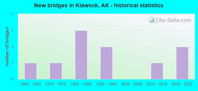
- New bridges - historical statistics
- 11960-1969
- 11970-1979
- 31980-1989
- 21990-1999
- 12010-2019
- 22020-2022


- Bridge Condition - Deck
- 14.3%Very good
- 42.9%Good
- 28.6%Satisfactory
- 14.3%Fair

- Bridge Condition - Superstructure
- 28.6%Very good
- 14.3%Good
- 28.6%Satisfactory
- 28.6%Fair

- Bridge Condition - Substructure
- 28.6%Very good
- 28.6%Good
- 42.9%Satisfactory

- Bridge Condition - Channel
- 11.1%Excellent
- 44.4%Very good
- 22.2%Good
- 22.2%Fair

- Bridge Condition - Culverts
- 66.7%Good
- 33.3%Satisfactory
Find on map >> Show street view
Structure Number: 481, Location: MILE POINT 19.4 (Lat: 55.468056, Lng: -132.856944), Route carried "on" structure: State highway 924, Year Built: 1969, Status: Open, Structure Length: 2.47m (8.10ft), Average Daily Traffic: 270 (year 2020), Truck Traffic: 21%, Average Future Daily Traffic: 330 (year 2039), Design Load: HS 20+Mod, Features Intersected: HARRIS RIVER, Facility Carried by Structure: CRAIG/KLAWOCK/HOLL
Minimum Vertical Clearance: 30+ m (98+ ft), Kilometerpoint: 31.262, Lanes on structure: 2, Owner: State Highway Agency, Approaching Roadway Width: 8.5m (27.9ft), Skew: 2 degrees, Material/Design: Steel, Design/Construction: Stringer/Multi-beam, Number Of Spans In Main Unit: 1, Length of Maximum Span: 23.8m (78.1ft), Curb-To-Curb Width: 8.6m (28.2ft), Out-to-Out Width: 9.1m (29.9ft)
Condition: Deck: Good, Superstructure: Satisfactory, Substructure: Satisfactory, Channel: Very good, Operating Rating: 85.4 metric tons, Method Used To Determine Operating Rating: Load Factor (LF), Inventory Rating: 39.4 metric tons, Method Used To Determine Inventory Rating: Load Factor (LF), Structural Evaluation: Equal to present minimum criteria, Deck Geometry: Equal to present minimum criteria, Waterway Adequacy: Superior to present desirable criteria, Approach Roadway Alignment: Better than present minimum criteria, Designated Inspection Frequency: Every 24 months, Inspection Date: July 2021, Deck Structure Type: Concrete Cast-file-Place, Wearing Surface/Protective System: Wearing Surface: Monolithic Concrete
Find on map >> Show street view
Structure Number: 802, Location: PETERSBURG (Lat: 56.807861, Lng: -132.975425), Route carried "on" structure: State highway 937, Year Built: 1986, Status: Open, Structure Length: 15.24m (50.00ft), Average Daily Traffic: 53 (year 2018), Truck Traffic: 8%, Average Future Daily Traffic: 100 (year 2035), Design Load: HS 20, Features Intersected: PETERSBURG FERRY TERM, Facility Carried by Structure: MARINE HWY ROUTE
Minimum Vertical Clearance: 30+ m (98+ ft), Kilometerpoint: 0.209, Lanes on structure: 1, Toll: On toll road, Owner: State Highway Agency, Approaching Roadway Width: 4.9m (16.1ft), Material/Design: Steel, Design/Construction: Box Beam or Girders - Multiple, Number Of Spans In Main Unit: 1, Number Of Approach Spans: 6, Length of Maximum Span: 42.7m (140.1ft), Curb-To-Curb Width: 4.9m (16.1ft), Out-to-Out Width: 4.9m (16.1ft)
Condition: Deck: Satisfactory, Superstructure: Satisfactory, Substructure: Good, Channel: Very good, Operating Rating: 64.0 metric tons, Method Used To Determine Operating Rating: Load Factor (LF), Inventory Rating: 29.0 metric tons, Method Used To Determine Inventory Rating: Load Factor (LF), Structural Evaluation: Equal to present minimum criteria, Deck Geometry: High priority of corrective action, Waterway Adequacy: Superior to present desirable criteria, Approach Roadway Alignment: Equal to present minimum criteria, Designated Inspection Frequency: Every 24 months, Critical Feature Inspection Frequency: Every 24 months, Underwater Inspection Frequency: Every 60 months, Inspection Date: May 2021, Critical Feature Inspection Date: May 2021, Underwater Inspection Date: August 2021, Deck Structure Type: Open Grating, Wearing Surface/Protective System: Deck Protection: Other
Find on map >> Show street view
Structure Number: 803, Location: AUKE BAY (Lat: 58.381642, Lng: -134.688269), Route carried "on" structure: State highway 93, Year Built: 1989, Status: Open, Structure Length: 5.12m (16.80ft), Average Daily Traffic: 45 (year 2018), Truck Traffic: 26%, Average Future Daily Traffic: 100 (year 2035), Design Load: HS 20, Features Intersected: AUKE BAY F.T. - WEST, Facility Carried by Structure: MARINE HWY ROUTE
Minimum Vertical Clearance: 30+ m (98+ ft), Kilometerpoint: 0.076, Lanes on structure: 1, Base Highway Network: Yes, Toll: On toll road, Owner: State Highway Agency, Approaching Roadway Width: 4.9m (16.1ft), Material/Design: Steel, Design/Construction: Box Beam or Girders - Multiple, Number Of Spans In Main Unit: 1, Length of Maximum Span: 42.7m (140.1ft), Curb-To-Curb Width: 4.8m (15.7ft), Out-to-Out Width: 5.1m (16.7ft)
Condition: Deck: Satisfactory, Superstructure: Fair, Substructure: Satisfactory, Channel: Excellent, Operating Rating: 64.0 metric tons, Method Used To Determine Operating Rating: Load Factor (LF), Inventory Rating: 29.8 metric tons, Method Used To Determine Inventory Rating: Load Factor (LF), Structural Evaluation: Somewhat better than minimum adequacy, Deck Geometry: Equal to present desirable criteria, Waterway Adequacy: Superior to present desirable criteria, Approach Roadway Alignment: Better than present minimum criteria, Designated Inspection Frequency: Every 24 months, Critical Feature Inspection Frequency: Every 24 months, Underwater Inspection Frequency: Every 60 months, Inspection Date: May 2021, Critical Feature Inspection Date: May 2021, Underwater Inspection Date: August 2021, Deck Structure Type: Open Grating, Wearing Surface/Protective System: Deck Protection: Other
Find on map >> Show street view
Structure Number: 1325, Location: MILE POINT 121.3 (Lat: 61.144722, Lng: -149.856389), Route carried "on" structure: Interstate A31, Year Built: 1976, Status: Open, Structure Length: 3.35m (10.99ft), Average Daily Traffic: 41,300 (year 2020), Truck Traffic: 4%, Average Future Daily Traffic: 53,500 (year 2039), Design Load: HS 20, Features Intersected: DIMOND BLVD UNDERXING, Facility Carried by Structure: SEWARD HIGHWAY
Minimum Vertical Clearance: 5.11m (16.77ft), Kilometerpoint: 195.157, Lanes on structure: 5, Lanes under structure: 6, Base Highway Network: Yes, Owner: State Highway Agency, Approaching Roadway Width: 24.4m (80.1ft), Skew: 20 degrees, Material/Design: Prestressed concrete, Design/Construction: Tee Beam, Number Of Spans In Main Unit: 1, Length of Maximum Span: 33.2m (108.9ft), Curb-To-Curb Width: 30.5m (100.1ft), Out-to-Out Width: 32.0m (105.0ft)
Condition: Deck: Fair, Superstructure: Fair, Substructure: Satisfactory, Operating Rating: 70.5 metric tons, Method Used To Determine Operating Rating: Load Factor (LF), Inventory Rating: 26.4 metric tons, Method Used To Determine Inventory Rating: Load Factor (LF), Structural Evaluation: Somewhat better than minimum adequacy, Deck Geometry: Superior to present desirable criteria, Underclear: Somewhat better than minimum adequacy, Approach Roadway Alignment: Equal to present desirable criteria, Designated Inspection Frequency: Every 24 months, Inspection Date: June 2021, Deck Structure Type: Other, Wearing Surface/Protective System: Wearing Surface: Bituminous
Find on map >> Show street view
Structure Number: 136, Location: MILE POINT 5.9 (Lat: 55.589300, Lng: -133.031800), Route carried "on" structure: State highway 929, Year Built: 1998, Status: Open, Structure Length: 3.11m (10.20ft), Average Daily Traffic: 310 (year 2020), Truck Traffic: 28%, Average Future Daily Traffic: 380 (year 2039), Design Load: HS 20, Features Intersected: LITTLE SALT CREEK, Facility Carried by Structure: BIG SALT LAKE ROAD
Minimum Vertical Clearance: 30+ m (98+ ft), Kilometerpoint: 9.505, Lanes on structure: 2, Owner: State Highway Agency, Approaching Roadway Width: 8.8m (28.9ft), Material/Design: Prestressed concrete, Design/Construction: Tee Beam, Number Of Spans In Main Unit: 1, Length of Maximum Span: 30.2m (99.1ft), Curb-To-Curb Width: 9.0m (29.5ft), Out-to-Out Width: 9.9m (32.5ft)
Condition: Deck: Very good, Superstructure: Very good, Substructure: Very good, Channel: Fair, Operating Rating: 89.6 metric tons, Method Used To Determine Operating Rating: Load Factor (LF), Inventory Rating: 41.3 metric tons, Method Used To Determine Inventory Rating: Load Factor (LF), Structural Evaluation: Equal to present desirable criteria, Deck Geometry: Equal to present minimum criteria, Waterway Adequacy: Equal to present desirable criteria, Approach Roadway Alignment: Equal to present desirable criteria, Designated Inspection Frequency: Every 24 months, Inspection Date: July 2021, Deck Structure Type: Other, Wearing Surface/Protective System: Wearing Surface: Bituminous, Membrane: Preformed Fabric, Deck Protection: Epoxy Coated Reinforcing
Find on map >> Show street view
Structure Number: 1375, Location: MILE POINT 1.7 (Lat: 55.568611, Lng: -133.062778), Route carried "on" structure: State highway 929, Year Built: 1985, Status: Open, Structure Length: 2.68m (8.79ft), Average Daily Traffic: 680 (year 2020), Truck Traffic: 15%, Average Future Daily Traffic: 1,830 (year 2039), Design Load: HS 20, Features Intersected: BENNETT CREEK, Facility Carried by Structure: BIG SALT LAKE ROAD
Minimum Vertical Clearance: 30+ m (98+ ft), Kilometerpoint: 2.789, Lanes on structure: 2, Owner: State Highway Agency, Approaching Roadway Width: 11.0m (36.1ft), Material/Design: Prestressed concrete, Design/Construction: Tee Beam, Number Of Spans In Main Unit: 1, Length of Maximum Span: 25.9m (85.0ft), Curb-To-Curb Width: 8.8m (28.9ft), Out-to-Out Width: 9.1m (29.9ft)
Condition: Deck: Good, Superstructure: Very good, Substructure: Very good, Channel: Very good, Inventory Rating: 50.0 metric tons, Method Used To Determine Inventory Rating: Load Factor (LF), Structural Evaluation: Equal to present desirable criteria, Deck Geometry: Somewhat better than minimum adequacy, Waterway Adequacy: Superior to present desirable criteria, Approach Roadway Alignment: Equal to present minimum criteria, Designated Inspection Frequency: Every 24 months, Inspection Date: July 2021, Deck Structure Type: Other, Wearing Surface/Protective System: Wearing Surface: Bituminous, Membrane: Preformed Fabric
Find on map >> Show street view
Structure Number: 4063, Location: MILE POINT 4.1 (Lat: 55.603889, Lng: -133.004444), Route carried "on" structure: State highway 929, Year Built: 1999, Status: Open, Structure Length: 0.88m (2.89ft), Average Daily Traffic: 310 (year 2020), Truck Traffic: 28%, Average Future Daily Traffic: 660 (year 2039), Features Intersected: DUKE CREEK, Facility Carried by Structure: BIG SALT LAKE ROAD
Minimum Vertical Clearance: 30+ m (98+ ft), Kilometerpoint: 6.571, Lanes on structure: 2, Owner: State Highway Agency, Approaching Roadway Width: 11.0m (36.1ft), Skew: 4 degrees, Material/Design: Steel, Design/Construction: Culvert, Number Of Spans In Main Unit: 1, Length of Maximum Span: 8.8m (28.9ft)
Condition: Channel: Very good, Culverts: Good, Operating Rating: 70.0 metric tons, Method Used To Determine Operating Rating: Load Factor (LF), Inventory Rating: 66.6 metric tons, Method Used To Determine Inventory Rating: Load Factor (LF), Structural Evaluation: Better than present minimum criteria, Waterway Adequacy: Equal to present desirable criteria, Approach Roadway Alignment: Meets minimum limits, Designated Inspection Frequency: Every 24 months, Inspection Date: July 2021
Find on map >> Show street view
Structure Number: 1008-2, Location: 0.21 MI W OF CRG/KLWK HWY (Lat: 55.543194, Lng: -133.102533), Route carried "on" structure: Federal lands road 1008, Year Built: 2015, Status: Open, Structure Length: 3.05m (10.01ft), Average Daily Traffic: 60 (year 2021), Average Future Daily Traffic: 120 (year 2041), Features Intersected: KLAWOCK SLOUGH
Minimum Vertical Clearance: 30+ m (98+ ft), Kilometerpoint: 0.280, Lanes on structure: 2, Owner: Indian Tribal Government, Approaching Roadway Width: 6.7m (22.0ft), Material/Design: Steel, Design/Construction: Stringer/Multi-beam, Number Of Spans In Main Unit: 1, Length of Maximum Span: 30.5m (100.1ft), Curb-To-Curb Width: 6.7m (22.0ft), Out-to-Out Width: 7.6m (24.9ft)
Condition: Deck: Good, Superstructure: Good, Substructure: Good, Channel: Good, Operating Rating: 39.0 metric tons, Method Used To Determine Operating Rating: Load Factor (LF), Inventory Rating: 22.7 metric tons, Method Used To Determine Inventory Rating: Load Factor (LF), Structural Evaluation: Equal to present minimum criteria, Deck Geometry: Somewhat better than minimum adequacy, Waterway Adequacy: Superior to present desirable criteria, Approach Roadway Alignment: Equal to present desirable criteria, Designated Inspection Frequency: Every 24 months, Inspection Date: June 2021, Deck Structure Type: Concrete Cast-file-Place
Find on map >> Show street view
Structure Number: 1017-2, Location: 0.36 MI NORTH OF BIG SALT (Lat: 55.588694, Lng: -133.041917), Route carried "on" structure: Federal lands road 1017, Year Built: 2020, Status: Open, Structure Length: 0.88m (2.89ft), Average Daily Traffic: 30 (year 2021), Truck Traffic: 5%, Average Future Daily Traffic: 60 (year 2041), Features Intersected: UNNAMED CREEK
Minimum Vertical Clearance: 30+ m (98+ ft), Kilometerpoint: 0.570, Lanes on structure: 2, Owner: Indian Tribal Government, Maintenance Responsibility: Local Agency, Approaching Roadway Width: 12.0m (39.4ft), Material/Design: Aluminum, Iron, Design/Construction: Culvert, Number Of Spans In Main Unit: 1, Length of Maximum Span: 8.8m (28.9ft)
Condition: Channel: Fair, Culverts: Satisfactory, Operating Rating: 46.3 metric tons, Method Used To Determine Operating Rating: Load Factor (LF), Inventory Rating: 27.2 metric tons, Method Used To Determine Inventory Rating: Load Factor (LF), Structural Evaluation: Equal to present minimum criteria, Waterway Adequacy: Equal to present minimum criteria, Approach Roadway Alignment: Equal to present desirable criteria, Length Of Structure Improvement: 1.50m (4.92ft), Designated Inspection Frequency: Every 24 months, Inspection Date: June 2021, Wearing Surface/Protective System: Wearing Surface: Gravel
Find on map >> Show street view
Structure Number: 1017-4, Location: 0.41 MI NORTH OF BIG SALT (Lat: 55.588972, Lng: -133.042139), Route carried "on" structure: Federal lands road 1017, Year Built: 2020, Status: Open, Structure Length: 0.70m (2.30ft), Average Daily Traffic: 30 (year 2021), Truck Traffic: 5%, Average Future Daily Traffic: 60 (year 2041), Design Load: HS 20, Features Intersected: UNNAMED CREEK
Minimum Vertical Clearance: 30+ m (98+ ft), Kilometerpoint: 0.660, Lanes on structure: 2, Owner: Indian Tribal Government, Maintenance Responsibility: Local Agency, Approaching Roadway Width: 14.3m (46.9ft), Skew: 1 degrees, Material/Design: Aluminum, Iron, Design/Construction: Culvert, Number Of Spans In Main Unit: 1, Length of Maximum Span: 7.0m (23.0ft)
Condition: Channel: Good, Culverts: Good, Operating Rating: 34.5 metric tons, Method Used To Determine Operating Rating: Load Factor (LF), Inventory Rating: 20.9 metric tons, Method Used To Determine Inventory Rating: Load Factor (LF), Structural Evaluation: Equal to present minimum criteria, Waterway Adequacy: Equal to present minimum criteria, Approach Roadway Alignment: Equal to present desirable criteria, Length Of Structure Improvement: 1.20m (3.94ft), Designated Inspection Frequency: Every 24 months, Inspection Date: June 2021, Wearing Surface/Protective System: Wearing Surface: Gravel