Bridge Statistics for Kremmling, Colorado (CO)
Condition, Traffic, Stress, Structural Evaluation, Project Costs
- National Bridge Inventory (NBI) Statistics
- 10Number of bridges
- 102ft / 31.0mTotal length
- 29,277Total average daily traffic
- 2,832Total average daily truck traffic
- 38,334Total future (year 2037) average daily traffic
- National Bridge Inventory (NBI) Registered Bridges for Kremmling
- No street view available for this location
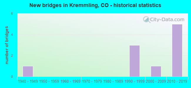
- New bridges - historical statistics
- 11940-1949
- 31990-1999
- 12000-2009
- 52010-2019


- Bridge Condition - Deck
- 60.0%Good
- 20.0%Satisfactory
- 20.0%Poor

- Bridge Condition - Superstructure
- 20.0%Very good
- 40.0%Good
- 40.0%Satisfactory

- Bridge Condition - Substructure
- 40.0%Very good
- 40.0%Good
- 20.0%Fair

- Bridge Condition - Channel
- 66.7%Very good
- 16.7%Satisfactory
- 16.7%Fair

- Bridge Condition - Culverts
- 40.0%Very good
- 60.0%Good
Find on map >> Show street view
Structure Number: 49000101.1006A, Location: 0.75 Mi West of St Hwy 9 (Lat: 40.028811, Lng: -106.386975), Route carried "on" structure: County highway , Year Built: 1990, Status: Open, Structure Length: 3.20m (10.50ft), Average Daily Traffic: 1,177 (year 2021), Truck Traffic: 27%, Average Future Daily Traffic: 1,389 (year 2041), Design Load: HS 20, Features Intersected: Blue River, Facility Carried by Structure: County Road 1
Minimum Vertical Clearance: 30+ m (98+ ft), Kilometerpoint: 1.379, Lanes on structure: 2, Owner: County Highway Agency, Approaching Roadway Width: 8.5m (27.9ft), Skew: 3 degrees, Material/Design: Prestressed concrete, Design/Construction: Stringer/Multi-beam, Number Of Spans In Main Unit: 1, Length of Maximum Span: 31.1m (102.0ft), Curb-To-Curb Width: 9.8m (32.2ft), Out-to-Out Width: 10.5m (34.4ft)
Condition: Deck: Satisfactory, Superstructure: Satisfactory, Substructure: Very good, Channel: Very good, Operating Rating: 60.8 metric tons, Method Used To Determine Operating Rating: Load Factor (LF), Inventory Rating: 36.3 metric tons, Method Used To Determine Inventory Rating: Load Factor (LF), Structural Evaluation: Equal to present minimum criteria, Deck Geometry: Somewhat better than minimum adequacy, Waterway Adequacy: Equal to present desirable criteria, Approach Roadway Alignment: Equal to present desirable criteria, Designated Inspection Frequency: Every 24 months, Inspection Date: September 2021, Deck Structure Type: Concrete Cast-file-Place, Wearing Surface/Protective System: Wearing Surface: Monolithic Concrete, Deck Protection: Epoxy Coated Reinforcing
Find on map >> Show street view
Structure Number: D-11-J, Location: S EDGE OF KREMMLING (Lat: 40.041525, Lng: -106.372997), Route carried "on" structure: State highway 9D, Year Built: 2004, Status: Open, Structure Length: 10.03m (32.91ft), Average Daily Traffic: 3,500 (year 2020), Truck Traffic: 11%, Average Future Daily Traffic: 4,200 (year 2040), Design Load: HS 25 or greater, Features Intersected: COLORADO RIVER, Facility Carried by Structure: SH 9 ML
Minimum Vertical Clearance: 30+ m (98+ ft), Kilometerpoint: 57.008, Lanes on structure: 2, Base Highway Network: Yes, Owner: State Highway Agency, Approaching Roadway Width: 12.2m (40.0ft), Skew: 3 degrees, Material/Design: Prestressed concrete continuous, Design/Construction: Stringer/Multi-beam, Number Of Spans In Main Unit: 3, Length of Maximum Span: 46.2m (151.6ft), Curb-To-Curb Width: 12.2m (40.0ft), Out-to-Out Width: 13.1m (43.0ft)
Condition: Deck: Good, Superstructure: Good, Substructure: Good, Channel: Very good, Operating Rating: 48.1 metric tons, Method Used To Determine Operating Rating: Load Factor (LF), Inventory Rating: 23.6 metric tons, Method Used To Determine Inventory Rating: Load Factor (LF), Structural Evaluation: Equal to present minimum criteria, Deck Geometry: Equal to present minimum criteria, Waterway Adequacy: Equal to present desirable criteria, Approach Roadway Alignment: Better than present minimum criteria, Length Of Structure Improvement: 12.44m (40.81ft), Designated Inspection Frequency: Every 24 months, Inspection Date: December 2020, Deck Structure Type: Concrete Cast-file-Place, Wearing Surface/Protective System: Wearing Surface: Bituminous, Membrane: Built-up, Deck Protection: Epoxy Coated Reinforcing
Find on map >> Show street view
Structure Number: D-11-N, Location: S. EDGE OF KREMMLING (Lat: 40.049736, Lng: -106.371242), Route carried "on" structure: State highway 9D, Year Built: 1942, Status: Open, Structure Length: 5.25m (17.22ft), Average Daily Traffic: 3,500 (year 2020), Truck Traffic: 11%, Average Future Daily Traffic: 4,200 (year 2040), Design Load: H 20, Features Intersected: UP RR, Facility Carried by Structure: SH 9 ML
Minimum Vertical Clearance: 30.45m (99.90ft), Kilometerpoint: 57.946, Lanes on structure: 2, Base Highway Network: Yes, Owner: State Highway Agency, Approaching Roadway Width: 7.9m (25.9ft), Material/Design: Steel, Design/Construction: Stringer/Multi-beam, Number Of Spans In Main Unit: 5, Length of Maximum Span: 13.1m (43.0ft), Curb-To-Curb Width: 9.1m (29.9ft), Out-to-Out Width: 10.3m (33.8ft)
Condition: Deck: Poor, Superstructure: Satisfactory, Substructure: Fair, Operating Rating: 39.9 metric tons, Method Used To Determine Operating Rating: Load Factor (LF), Inventory Rating: 23.6 metric tons, Method Used To Determine Inventory Rating: Load Factor (LF), Structural Evaluation: Somewhat better than minimum adequacy, Deck Geometry: Meets minimum limits, Underclear: Meets minimum limits, Approach Roadway Alignment: Equal to present minimum criteria, Designated Inspection Frequency: Every 24 months, Inspection Date: October 2020, Deck Structure Type: Concrete Cast-file-Place, Wearing Surface/Protective System: Wearing Surface: Bituminous
Find on map >> Show street view
Structure Number: D-11-Q, Location: 4.62 MI E OF JCT SH9 (Lat: 40.058772, Lng: -106.305317), Route carried "on" structure: US 40A, Year Built: 1996, Status: Open, Structure Length: 3.33m (10.93ft), Average Daily Traffic: 2,400 (year 2020), Truck Traffic: 8%, Average Future Daily Traffic: 2,976 (year 2040), Design Load: HS 20+Mod, Features Intersected: TROUBLESOME CREEK, Facility Carried by Structure: US 40 ML
Minimum Vertical Clearance: 30+ m (98+ ft), Kilometerpoint: 303.429, Lanes on structure: 2, Base Highway Network: Yes, Owner: State Highway Agency, Approaching Roadway Width: 7.3m (24.0ft), Material/Design: Prestressed concrete, Design/Construction: Box Beam or Girders - Multiple, Number Of Spans In Main Unit: 1, Length of Maximum Span: 32.5m (106.6ft), Curb-To-Curb Width: 12.2m (40.0ft), Out-to-Out Width: 12.9m (42.3ft)
Condition: Deck: Good, Superstructure: Very good, Substructure: Very good, Channel: Fair, Operating Rating: 80.8 metric tons, Method Used To Determine Operating Rating: Allowable Stress (AS), Inventory Rating: 39.9 metric tons, Method Used To Determine Inventory Rating: Allowable Stress (AS), Structural Evaluation: Equal to present desirable criteria, Deck Geometry: Equal to present minimum criteria, Waterway Adequacy: Equal to present minimum criteria, Approach Roadway Alignment: Equal to present desirable criteria, Designated Inspection Frequency: Every 24 months, Inspection Date: December 2020, Deck Structure Type: Concrete Cast-file-Place, Wearing Surface/Protective System: Wearing Surface: Bituminous, Membrane: Preformed Fabric, Deck Protection: Epoxy Coated Reinforcing
Find on map >> Show street view
Structure Number: D-11-T, Location: IN KREMMLING (Lat: 40.060661, Lng: -106.398997), Route carried "on" structure: US 40A, Year Built: 1996, Status: Open, Structure Length: 3.09m (10.14ft), Average Daily Traffic: 3,100 (year 2020), Truck Traffic: 11%, Average Future Daily Traffic: 3,441 (year 2040), Design Load: HS 20+Mod, Features Intersected: BIG MUDDY CREEK, Facility Carried by Structure: US 40 ML
Minimum Vertical Clearance: 30+ m (98+ ft), Kilometerpoint: 294.978, Lanes on structure: 2, Base Highway Network: Yes, Owner: State Highway Agency, Approaching Roadway Width: 7.9m (25.9ft), Material/Design: Prestressed concrete, Design/Construction: Box Beam or Girders - Multiple, Number Of Spans In Main Unit: 1, Length of Maximum Span: 30.0m (98.4ft), Curb-To-Curb Width: 12.1m (39.7ft), Out-to-Out Width: 12.9m (42.3ft)
Condition: Deck: Good, Superstructure: Good, Substructure: Good, Channel: Satisfactory, Operating Rating: 81.7 metric tons, Method Used To Determine Operating Rating: Allowable Stress (AS), Inventory Rating: 39.9 metric tons, Method Used To Determine Inventory Rating: Allowable Stress (AS), Structural Evaluation: Better than present minimum criteria, Deck Geometry: Somewhat better than minimum adequacy, Waterway Adequacy: Equal to present desirable criteria, Approach Roadway Alignment: Equal to present desirable criteria, Designated Inspection Frequency: Every 24 months, Inspection Date: December 2020, Deck Structure Type: Concrete Cast-file-Place, Wearing Surface/Protective System: Wearing Surface: Bituminous, Membrane: Preformed Fabric, Deck Protection: Epoxy Coated Reinforcing
Find on map >> Show street view
Structure Number: E-12-K, Location: 11.1 miles south of US-40 (Lat: 39.917617, Lng: -106.329425), Route carried "on" structure: State highway 9D, Year Built: 2017, Status: Open, Structure Length: 1.22m (4.00ft), Average Daily Traffic: 3,600 (year 2020), Truck Traffic: 8%, Average Future Daily Traffic: 4,932 (year 2040), Design Load: HL 93, Features Intersected: WILDLIFE UNDERPASS, Facility Carried by Structure: SH 9 ML
Minimum Vertical Clearance: 30+ m (98+ ft), Kilometerpoint: 42.189, Lanes on structure: 2, Owner: State Highway Agency, Approaching Roadway Width: 12.2m (40.0ft), Material/Design: Concrete, Design/Construction: Culvert, Number Of Spans In Main Unit: 1, Length of Maximum Span: 12.2m (40.0ft), Curb-To-Curb Width: 12.2m (40.0ft), Out-to-Out Width: 20.1m (65.9ft)
Condition: Channel: Very good, Culverts: Good, Operating Rating: 47.3 metric tons, Method Used To Determine Operating Rating: Load and Resistance Factor Rating (LRFR) rating reported by rating factor(RF) method using HL-93 loadings, Inventory Rating: 37.3 metric tons, Method Used To Determine Inventory Rating: Load and Resistance Factor Rating (LRFR) rating reported by rating factor(RF) method using HL-93 loadings, Structural Evaluation: Better than present minimum criteria, Deck Geometry: Equal to present minimum criteria, Approach Roadway Alignment: Equal to present desirable criteria, Designated Inspection Frequency: Every 24 months, Inspection Date: August 2021
Find on map >> Show street view
Structure Number: E-12-M, Location: 8.1 miles south of US-40 (Lat: 39.958319, Lng: -106.348558), Route carried "on" structure: State highway 9D, Year Built: 2017, Status: Open, Structure Length: 1.22m (4.00ft), Average Daily Traffic: 1,200 (year 2017), Truck Traffic: 5%, Average Future Daily Traffic: 2,400 (year 2037), Design Load: HL 93, Features Intersected: WILDLIFE UNDERPASS, Facility Carried by Structure: SH 9 ML
Minimum Vertical Clearance: 30+ m (98+ ft), Kilometerpoint: 44.463, Lanes on structure: 2, Owner: State Highway Agency, Approaching Roadway Width: 12.2m (40.0ft), Material/Design: Concrete, Design/Construction: Culvert, Number Of Spans In Main Unit: 1, Length of Maximum Span: 12.2m (40.0ft), Curb-To-Curb Width: 12.2m (40.0ft), Out-to-Out Width: 20.1m (65.9ft)
Condition: Channel: Very good, Culverts: Very good, Operating Rating: 47.3 metric tons, Method Used To Determine Operating Rating: Load and Resistance Factor Rating (LRFR) rating reported by rating factor(RF) method using HL-93 loadings, Inventory Rating: 37.3 metric tons, Method Used To Determine Inventory Rating: Load and Resistance Factor Rating (LRFR) rating reported by rating factor(RF) method using HL-93 loadings, Structural Evaluation: Equal to present desirable criteria, Deck Geometry: Better than present minimum criteria, Approach Roadway Alignment: Equal to present desirable criteria, Designated Inspection Frequency: Every 24 months, Inspection Date: October 2021
Find on map >> Show street view
Structure Number: E-12-N, Location: 7.3 MI. S. O F US HWY 40 (Lat: 39.969736, Lng: -106.351208), Route carried "on" structure: State highway 9D, Year Built: 2017, Status: Open, Structure Length: 1.22m (4.00ft), Average Daily Traffic: 3,600 (year 2020), Truck Traffic: 8%, Average Future Daily Traffic: 4,932 (year 2040), Design Load: HL 93, Features Intersected: WILDLIFE UNDERPASS, Facility Carried by Structure: SH 9 ML
Minimum Vertical Clearance: 30+ m (98+ ft), Kilometerpoint: 48.396, Lanes on structure: 2, Owner: State Highway Agency, Approaching Roadway Width: 12.2m (40.0ft), Material/Design: Concrete, Design/Construction: Culvert, Number Of Spans In Main Unit: 1, Length of Maximum Span: 12.2m (40.0ft), Curb-To-Curb Width: 12.2m (40.0ft), Out-to-Out Width: 20.1m (65.9ft)
Condition: Culverts: Very good, Operating Rating: 47.3 metric tons, Method Used To Determine Operating Rating: Load and Resistance Factor Rating (LRFR) rating reported by rating factor(RF) method using HL-93 loadings, Inventory Rating: 37.3 metric tons, Method Used To Determine Inventory Rating: Load and Resistance Factor Rating (LRFR) rating reported by rating factor(RF) method using HL-93 loadings, Structural Evaluation: Equal to present desirable criteria, Deck Geometry: Equal to present minimum criteria, Approach Roadway Alignment: Equal to present desirable criteria, Designated Inspection Frequency: Every 24 months, Inspection Date: August 2021
Find on map >> Show street view
Structure Number: E-12-O, Location: 6.4 miles south of US-40 (Lat: 39.981997, Lng: -106.355953), Route carried "on" structure: State highway 9D, Year Built: 2017, Status: Open, Structure Length: 1.22m (4.00ft), Average Daily Traffic: 3,600 (year 2020), Truck Traffic: 8%, Average Future Daily Traffic: 4,932 (year 2040), Design Load: HL 93, Features Intersected: WILDLIFE UNDERPASS, Facility Carried by Structure: SH 9 ML
Minimum Vertical Clearance: 30+ m (98+ ft), Kilometerpoint: 49.820, Lanes on structure: 2, Owner: State Highway Agency, Approaching Roadway Width: 12.2m (40.0ft), Material/Design: Concrete, Design/Construction: Culvert, Number Of Spans In Main Unit: 1, Length of Maximum Span: 12.2m (40.0ft), Curb-To-Curb Width: 12.2m (40.0ft), Out-to-Out Width: 20.1m (65.9ft)
Condition: Culverts: Good, Operating Rating: 47.3 metric tons, Method Used To Determine Operating Rating: Load and Resistance Factor Rating (LRFR) rating reported by rating factor(RF) method using HL-93 loadings, Inventory Rating: 37.3 metric tons, Method Used To Determine Inventory Rating: Load and Resistance Factor Rating (LRFR) rating reported by rating factor(RF) method using HL-93 loadings, Structural Evaluation: Better than present minimum criteria, Deck Geometry: Equal to present minimum criteria, Approach Roadway Alignment: Equal to present desirable criteria, Designated Inspection Frequency: Every 24 months, Inspection Date: August 2021
Find on map >> Show street view
Structure Number: E-12-Q, Location: 2.8 miles south of US-40 (Lat: 40.028133, Lng: -106.376181), Route carried "on" structure: State highway 9D, Year Built: 2017, Status: Open, Structure Length: 1.23m (4.04ft), Average Daily Traffic: 3,600 (year 2020), Truck Traffic: 8%, Average Future Daily Traffic: 4,932 (year 2040), Design Load: HL 93, Features Intersected: WILDLIFE UNDERPASS, Facility Carried by Structure: SH 9 ML
Minimum Vertical Clearance: 30+ m (98+ ft), Kilometerpoint: 55.484, Lanes on structure: 2, Owner: State Highway Agency, Approaching Roadway Width: 12.2m (40.0ft), Material/Design: Concrete, Design/Construction: Culvert, Number Of Spans In Main Unit: 1, Length of Maximum Span: 12.3m (40.4ft), Curb-To-Curb Width: 12.2m (40.0ft), Out-to-Out Width: 20.1m (65.9ft)
Condition: Culverts: Good, Operating Rating: 47.3 metric tons, Method Used To Determine Operating Rating: Load and Resistance Factor Rating (LRFR) rating reported by rating factor(RF) method using HL-93 loadings, Inventory Rating: 37.3 metric tons, Method Used To Determine Inventory Rating: Load and Resistance Factor Rating (LRFR) rating reported by rating factor(RF) method using HL-93 loadings, Structural Evaluation: Better than present minimum criteria, Deck Geometry: Equal to present minimum criteria, Approach Roadway Alignment: Equal to present desirable criteria, Designated Inspection Frequency: Every 24 months, Inspection Date: August 2021