Bridge Statistics for Kuttawa, Kentucky (KY)
Condition, Traffic, Stress, Structural Evaluation, Project Costs
- National Bridge Inventory (NBI) Statistics
- 29Number of bridges
- 272ft / 83.0mTotal length
- $4,338,000Total costs
- 232,153Total average daily traffic
- 76,583Total average daily truck traffic
- National Bridge Inventory (NBI) Registered Bridges for Kuttawa
- No street view available for this location
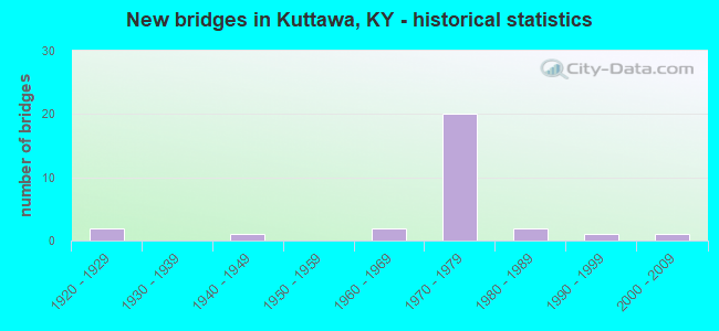
- New bridges - historical statistics
- 21920-1929
- 11940-1949
- 21960-1969
- 201970-1979
- 21980-1989
- 11990-1999
- 12000-2009


- Bridge Condition - Deck
- 76.5%Good
- 11.8%Satisfactory
- 11.8%Fair

- Bridge Condition - Superstructure
- 64.7%Good
- 17.6%Satisfactory
- 17.6%Fair

- Bridge Condition - Substructure
- 58.8%Good
- 35.3%Satisfactory
- 5.9%Fair

- Bridge Condition - Channel
- 22.2%Very good
- 22.2%Good
- 44.4%Satisfactory
- 11.1%Poor

- Bridge Condition - Culverts
- 50.0%Satisfactory
- 50.0%Fair
Find on map >> Show street view
Structure Number: 72B00010N, Location: 1.5 MI N.W. OF JCT KY 819 (Lat: 37.080556, Lng: -88.170000), Route carried "on" structure: State highway 93, Year Built: 1928, Status: Open, Structure Length: 0.79m (2.59ft), Average Daily Traffic: 324 (year 2019), Average Future Daily Traffic: 285 (year 2039), Design Load: H 15, Features Intersected: PANTHER CREEK
Minimum Vertical Clearance: 30+ m (98+ ft), Kilometerpoint: 30.421, Lanes on structure: 2, Owner: State Highway Agency, Approaching Roadway Width: 6.1m (20.0ft), Skew: 4 degrees, Material/Design: Concrete, Design/Construction: Culvert, Number Of Spans In Main Unit: 2, Length of Maximum Span: 2.4m (7.9ft)
Condition: Channel: Poor, Culverts: Fair, Operating Rating: 82.0 metric tons, Method Used To Determine Operating Rating: Load Factor (LF), Inventory Rating: 49.0 metric tons, Method Used To Determine Inventory Rating: Load Factor (LF), Structural Evaluation: Somewhat better than minimum adequacy, Waterway Adequacy: Superior to present desirable criteria, Approach Roadway Alignment: Equal to present desirable criteria, Designated Inspection Frequency: Every 24 months, Inspection Date: July 2020
Find on map >> Show street view
Structure Number: 72B00011N, Location: .55 MI EAST OF JCT KY 819 (Lat: 37.086111, Lng: -88.183333), Route carried "on" structure: State highway 93, Year Built: 1928, Status: Open, Structure Length: 1.28m (4.20ft), Average Daily Traffic: 324 (year 2019), Average Future Daily Traffic: 285 (year 2039), Design Load: H 15, Features Intersected: PANTHER CREEK
Minimum Vertical Clearance: 30+ m (98+ ft), Kilometerpoint: 31.780, Lanes on structure: 2, Owner: State Highway Agency, Approaching Roadway Width: 5.5m (18.0ft), Skew: 3 degrees, Material/Design: Concrete, Design/Construction: Tee Beam, Number Of Spans In Main Unit: 1, Length of Maximum Span: 11.6m (38.1ft), Curb or Sidewalk Widths: Left: 0.2m (0.7ft), Right: 0.2m (0.7ft), Curb-To-Curb Width: 7.1m (23.3ft), Out-to-Out Width: 7.9m (25.9ft)
Condition: Deck: Satisfactory, Superstructure: Satisfactory, Substructure: Satisfactory, Channel: Very good, Operating Rating: 59.5 metric tons, Method Used To Determine Operating Rating: Load Factor (LF), Inventory Rating: 35.7 metric tons, Method Used To Determine Inventory Rating: Load Factor (LF), Structural Evaluation: Equal to present minimum criteria, Deck Geometry: Meets minimum limits, Waterway Adequacy: Superior to present desirable criteria, Approach Roadway Alignment: Equal to present desirable criteria, Designated Inspection Frequency: Every 24 months, Inspection Date: June 2020, Deck Structure Type: Concrete Cast-file-Place, Wearing Surface/Protective System: Wearing Surface: Bituminous
Find on map >> Show street view
Structure Number: 72B00017N, Location: .05 MI W. OF JCT KY 810 (Lat: 37.049167, Lng: -88.166389), Route carried "on" structure: US 62, Year Built: 1948, Status: Open, Structure Length: 1.01m (3.31ft), Average Daily Traffic: 3,892 (year 2019), Truck Traffic: 23%, Average Future Daily Traffic: 3,230 (year 2039), Design Load: H 20, Features Intersected: BRANCH OF FLAT CR.
Minimum Vertical Clearance: 30+ m (98+ ft), Kilometerpoint: 5.955, Lanes on structure: 2, Base Highway Network: Yes, Owner: State Highway Agency, Approaching Roadway Width: 9.1m (29.9ft), Skew: 4 degrees, Material/Design: Concrete, Design/Construction: Culvert, Number Of Spans In Main Unit: 2, Length of Maximum Span: 3.0m (9.8ft)
Condition: Channel: Satisfactory, Culverts: Satisfactory, Operating Rating: 54.4 metric tons, Method Used To Determine Operating Rating: Field evaluation and documented engineering judgment, Inventory Rating: 40.8 metric tons, Method Used To Determine Inventory Rating: Field evaluation and documented engineering judgment, Structural Evaluation: Equal to present minimum criteria, Waterway Adequacy: Superior to present desirable criteria, Approach Roadway Alignment: Equal to present desirable criteria, Designated Inspection Frequency: Every 24 months, Inspection Date: June 2020
Find on map >> Show street view
Structure Number: 72B00032N, Location: 2.5 MI N OF JCT US 62 (Lat: 37.063333, Lng: -88.193333), Route carried "on" structure: State highway 6008, Year Built: 1977, Status: Open, Structure Length: 7.01m (23.00ft), Average Daily Traffic: 27 (year 2018), Average Future Daily Traffic: 23 (year 2038), Design Load: HS 20, Features Intersected: I-24 @ MP. 035.289
Minimum Vertical Clearance: 30+ m (98+ ft), Kilometerpoint: 0.497, Lanes on structure: 2, Lanes under structure: 4, Owner: State Highway Agency, Approaching Roadway Width: 6.1m (20.0ft), Material/Design: Steel continuous, Design/Construction: Stringer/Multi-beam, Number Of Spans In Main Unit: 2, Length of Maximum Span: 34.1m (111.9ft), Curb-To-Curb Width: 7.3m (24.0ft), Out-to-Out Width: 8.5m (27.9ft)
Condition: Deck: Good, Superstructure: Good, Substructure: Good, Operating Rating: 70.3 metric tons, Method Used To Determine Operating Rating: Load Factor (LF), Inventory Rating: 42.2 metric tons, Method Used To Determine Inventory Rating: Load Factor (LF), Structural Evaluation: Better than present minimum criteria, Deck Geometry: Equal to present minimum criteria, Underclear: Somewhat better than minimum adequacy, Approach Roadway Alignment: Equal to present desirable criteria, Designated Inspection Frequency: Every 24 months, Inspection Date: March 2020, Deck Structure Type: Concrete Cast-file-Place, Wearing Surface/Protective System: Wearing Surface: Monolithic Concrete, Deck Protection: Epoxy Coated Reinforcing
Find on map >> Show street view
Structure Number: 72B00033N, Location: 1 MI N OF JCT US 62 (Lat: 37.062778, Lng: -88.174167), Route carried "on" structure: State highway 810, Year Built: 1977, Status: Open, Structure Length: 6.58m (21.59ft), Average Daily Traffic: 364 (year 2018), Average Future Daily Traffic: 320 (year 2038), Design Load: HS 20, Features Intersected: I-24 @ MP. 036.406
Minimum Vertical Clearance: 30+ m (98+ ft), Kilometerpoint: 8.906, Lanes on structure: 2, Lanes under structure: 4, Owner: State Highway Agency, Approaching Roadway Width: 6.1m (20.0ft), Material/Design: Steel continuous, Design/Construction: Stringer/Multi-beam, Number Of Spans In Main Unit: 2, Number Of Approach Spans: 2, Length of Maximum Span: 32.0m (105.0ft), Curb-To-Curb Width: 8.5m (27.9ft), Out-to-Out Width: 8.9m (29.2ft)
Condition: Deck: Good, Superstructure: Good, Substructure: Good, Operating Rating: 57.8 metric tons, Method Used To Determine Operating Rating: Load Factor (LF), Inventory Rating: 34.7 metric tons, Method Used To Determine Inventory Rating: Load Factor (LF), Structural Evaluation: Better than present minimum criteria, Deck Geometry: Equal to present minimum criteria, Underclear: Somewhat better than minimum adequacy, Approach Roadway Alignment: Equal to present desirable criteria, Designated Inspection Frequency: Every 24 months, Inspection Date: March 2020, Deck Structure Type: Concrete Cast-file-Place, Wearing Surface/Protective System: Wearing Surface: Monolithic Concrete, Deck Protection: Epoxy Coated Reinforcing
Find on map >> Show street view
Structure Number: 72B00034N, Location: .5 MI S OF JCT KY 93 (Lat: 37.068611, Lng: -88.159722), Route carried "on" structure: State highway 6010, Year Built: 1977, Status: Open, Structure Length: 5.70m (18.70ft), Average Daily Traffic: 65 (year 2019), Average Future Daily Traffic: 56 (year 2039), Design Load: HS 20, Features Intersected: I-24 @ MP. 037.288
Minimum Vertical Clearance: 30+ m (98+ ft), Kilometerpoint: 0.135, Lanes on structure: 2, Lanes under structure: 4, Owner: State Highway Agency, Approaching Roadway Width: 6.1m (20.0ft), Material/Design: Steel continuous, Design/Construction: Stringer/Multi-beam, Number Of Spans In Main Unit: 2, Number Of Approach Spans: 2, Length of Maximum Span: 27.7m (90.9ft), Curb-To-Curb Width: 7.7m (25.3ft), Out-to-Out Width: 9.0m (29.5ft)
Condition: Deck: Good, Superstructure: Good, Substructure: Good, Operating Rating: 69.9 metric tons, Method Used To Determine Operating Rating: Load Factor (LF), Inventory Rating: 42.0 metric tons, Method Used To Determine Inventory Rating: Load Factor (LF), Structural Evaluation: Better than present minimum criteria, Deck Geometry: Equal to present minimum criteria, Underclear: Somewhat better than minimum adequacy, Approach Roadway Alignment: Equal to present desirable criteria, Designated Inspection Frequency: Every 24 months, Inspection Date: March 2020, Deck Structure Type: Concrete Cast-file-Place, Wearing Surface/Protective System: Wearing Surface: Monolithic Concrete, Deck Protection: Epoxy Coated Reinforcing
Find on map >> Show street view
Structure Number: 72B00035L, Location: WBL OVER ICG RR (Lat: 37.070278, Lng: -88.147500), Route carried "on" structure: Interstate 24, Year Built: 1977, Status: Open, Structure Length: 6.28m (20.60ft), Average Daily Traffic: 13,295 (year 2020), Truck Traffic: 37%, Average Future Daily Traffic: 16,220 (year 2040), Design Load: HS 20, Features Intersected: P&L RAILWAY
Minimum Vertical Clearance: 30+ m (98+ ft), Kilometerpoint: 61.060, Lanes on structure: 2, Base Highway Network: Yes, Owner: State Highway Agency, Approaching Roadway Width: 12.2m (40.0ft), Skew: 4 degrees, Material/Design: Steel continuous, Design/Construction: Stringer/Multi-beam, Number Of Spans In Main Unit: 3, Length of Maximum Span: 22.6m (74.1ft), Curb-To-Curb Width: 11.9m (39.0ft), Out-to-Out Width: 13.2m (43.3ft)
Condition: Deck: Good, Superstructure: Good, Substructure: Good, Operating Rating: 54.7 metric tons, Method Used To Determine Operating Rating: Load Factor (LF), Inventory Rating: 32.8 metric tons, Method Used To Determine Inventory Rating: Load Factor (LF), Structural Evaluation: Better than present minimum criteria, Deck Geometry: Equal to present minimum criteria, Underclear: Equal to present minimum criteria, Approach Roadway Alignment: Equal to present desirable criteria, Length Of Structure Improvement: 0.63m (2.07ft), Designated Inspection Frequency: Every 24 months, Inspection Date: Febuary 2020, Bridge Improvement Cost: $1,112,000, Total Project Cost: $1,112,000, Deck Structure Type: Concrete Cast-file-Place, Wearing Surface/Protective System: Wearing Surface: Latex Concrete
Find on map >> Show street view
Structure Number: 72B00035R, Location: EBL OVER ICG RR (Lat: 37.070000, Lng: -88.147778), Route carried "on" structure: Interstate 24, Year Built: 1977, Status: Open, Structure Length: 6.28m (20.60ft), Average Daily Traffic: 13,295 (year 2020), Truck Traffic: 37%, Average Future Daily Traffic: 16,220 (year 2040), Design Load: HS 20, Features Intersected: P&L RAILWAY
Minimum Vertical Clearance: 30+ m (98+ ft), Kilometerpoint: 61.079, Lanes on structure: 2, Base Highway Network: Yes, Owner: State Highway Agency, Approaching Roadway Width: 12.2m (40.0ft), Skew: 4 degrees, Material/Design: Steel continuous, Design/Construction: Stringer/Multi-beam, Number Of Spans In Main Unit: 3, Length of Maximum Span: 22.6m (74.1ft), Curb-To-Curb Width: 11.9m (39.0ft), Out-to-Out Width: 13.2m (43.3ft)
Condition: Deck: Good, Superstructure: Good, Substructure: Good, Operating Rating: 54.7 metric tons, Method Used To Determine Operating Rating: Load Factor (LF), Inventory Rating: 32.8 metric tons, Method Used To Determine Inventory Rating: Load Factor (LF), Structural Evaluation: Better than present minimum criteria, Deck Geometry: Equal to present minimum criteria, Underclear: Better than present minimum criteria, Approach Roadway Alignment: Equal to present desirable criteria, Length Of Structure Improvement: 0.63m (2.07ft), Designated Inspection Frequency: Every 24 months, Inspection Date: Febuary 2020, Bridge Improvement Cost: $1,112,000, Total Project Cost: $1,112,000, Deck Structure Type: Concrete Cast-file-Place, Wearing Surface/Protective System: Wearing Surface: Latex Concrete
Find on map >> Show street view
Structure Number: 72B00036L, Location: WBL 1 MI W OF US 62 NTRCH (Lat: 37.072500, Lng: -88.141667), Route carried "on" structure: Interstate 24, Year Built: 1977, Status: Open, Structure Length: 5.52m (18.11ft), Average Daily Traffic: 13,295 (year 2020), Truck Traffic: 37%, Average Future Daily Traffic: 16,220 (year 2040), Design Load: HS 20, Features Intersected: KY 93
Minimum Vertical Clearance: 30+ m (98+ ft), Kilometerpoint: 61.665, Lanes on structure: 2, Lanes under structure: 2, Base Highway Network: Yes, Owner: State Highway Agency, Approaching Roadway Width: 12.2m (40.0ft), Skew: 2 degrees, Material/Design: Steel continuous, Design/Construction: Stringer/Multi-beam, Number Of Spans In Main Unit: 3, Length of Maximum Span: 21.9m (71.9ft), Curb-To-Curb Width: 12.0m (39.4ft), Out-to-Out Width: 13.3m (43.6ft)
Condition: Deck: Good, Superstructure: Satisfactory, Substructure: Satisfactory, Operating Rating: 64.9 metric tons, Method Used To Determine Operating Rating: Load Factor (LF), Inventory Rating: 38.9 metric tons, Method Used To Determine Inventory Rating: Load Factor (LF), Structural Evaluation: Equal to present minimum criteria, Deck Geometry: Equal to present minimum criteria, Underclear: Superior to present desirable criteria, Approach Roadway Alignment: Equal to present desirable criteria, Length Of Structure Improvement: 0.55m (1.80ft), Designated Inspection Frequency: Every 24 months, Inspection Date: March 2020, Bridge Improvement Cost: $984,000, Total Project Cost: $984,000, Deck Structure Type: Concrete Cast-file-Place, Wearing Surface/Protective System: Wearing Surface: Latex Concrete
Find on map >> Show street view
Structure Number: 72B00036R, Location: EBL 1 MI W OF US 62 NTRCH (Lat: 37.072222, Lng: -88.141111), Route carried "on" structure: Interstate 24, Year Built: 1977, Status: Open, Structure Length: 5.94m (19.49ft), Average Daily Traffic: 13,295 (year 2020), Truck Traffic: 37%, Average Future Daily Traffic: 16,220 (year 2040), Design Load: HS 20, Features Intersected: KY 93
Minimum Vertical Clearance: 30+ m (98+ ft), Kilometerpoint: 61.744, Lanes on structure: 2, Lanes under structure: 2, Base Highway Network: Yes, Owner: State Highway Agency, Approaching Roadway Width: 12.2m (40.0ft), Skew: 3 degrees, Material/Design: Steel continuous, Design/Construction: Stringer/Multi-beam, Number Of Spans In Main Unit: 3, Length of Maximum Span: 24.4m (80.1ft), Curb-To-Curb Width: 12.0m (39.4ft), Out-to-Out Width: 13.3m (43.6ft)
Condition: Deck: Good, Superstructure: Good, Substructure: Good, Operating Rating: 60.5 metric tons, Method Used To Determine Operating Rating: Load Factor (LF), Inventory Rating: 36.3 metric tons, Method Used To Determine Inventory Rating: Load Factor (LF), Structural Evaluation: Better than present minimum criteria, Deck Geometry: Equal to present minimum criteria, Underclear: Superior to present desirable criteria, Approach Roadway Alignment: Equal to present desirable criteria, Length Of Structure Improvement: 0.59m (1.94ft), Designated Inspection Frequency: Every 24 months, Inspection Date: March 2020, Bridge Improvement Cost: $1,060,000, Total Project Cost: $1,060,000, Deck Structure Type: Concrete Cast-file-Place, Wearing Surface/Protective System: Wearing Surface: Latex Concrete
Find on map >> Show street view
Structure Number: 72B00037L, Location: WBL OVR US 62 NTRCH (Lat: 37.074167, Lng: -88.121667), Route carried "on" structure: Interstate 24, Year Built: 1977, Status: Open, Structure Length: 9.30m (30.51ft), Average Daily Traffic: 14,006 (year 2019), Truck Traffic: 34%, Average Future Daily Traffic: 17,087 (year 2039), Design Load: HS 20, Features Intersected: US 62
Minimum Vertical Clearance: 30+ m (98+ ft), Kilometerpoint: 63.596, Lanes on structure: 2, Lanes under structure: 4, Base Highway Network: Yes, Owner: State Highway Agency, Approaching Roadway Width: 12.1m (39.7ft), Skew: 3 degrees, Material/Design: Steel continuous, Design/Construction: Stringer/Multi-beam, Number Of Spans In Main Unit: 4, Length of Maximum Span: 26.8m (87.9ft), Curb-To-Curb Width: 12.1m (39.7ft), Out-to-Out Width: 13.2m (43.3ft)
Condition: Deck: Satisfactory, Superstructure: Satisfactory, Substructure: Good, Operating Rating: 57.5 metric tons, Method Used To Determine Operating Rating: Load Factor (LF), Inventory Rating: 34.5 metric tons, Method Used To Determine Inventory Rating: Load Factor (LF), Structural Evaluation: Equal to present minimum criteria, Deck Geometry: Equal to present minimum criteria, Underclear: Better than present minimum criteria, Approach Roadway Alignment: Equal to present desirable criteria, Designated Inspection Frequency: Every 24 months, Inspection Date: March 2020, Deck Structure Type: Concrete Cast-file-Place, Wearing Surface/Protective System: Wearing Surface: Latex Concrete
Find on map >> Show street view
Structure Number: 72B00037R, Location: EBL OVR US 62 NTRCH (Lat: 37.073889, Lng: -88.121944), Route carried "on" structure: Interstate 24, Year Built: 1977, Status: Open, Structure Length: 9.30m (30.51ft), Average Daily Traffic: 14,006 (year 2019), Truck Traffic: 34%, Average Future Daily Traffic: 17,087 (year 2039), Design Load: HS 20, Features Intersected: US 62
Minimum Vertical Clearance: 30+ m (98+ ft), Kilometerpoint: 63.621, Lanes on structure: 2, Lanes under structure: 4, Base Highway Network: Yes, Owner: State Highway Agency, Approaching Roadway Width: 12.2m (40.0ft), Skew: 3 degrees, Material/Design: Steel continuous, Design/Construction: Stringer/Multi-beam, Number Of Spans In Main Unit: 4, Length of Maximum Span: 27.7m (90.9ft), Curb-To-Curb Width: 12.1m (39.7ft), Out-to-Out Width: 13.2m (43.3ft)
Condition: Deck: Good, Superstructure: Good, Substructure: Good, Operating Rating: 57.5 metric tons, Method Used To Determine Operating Rating: Load Factor (LF), Inventory Rating: 34.5 metric tons, Method Used To Determine Inventory Rating: Load Factor (LF), Structural Evaluation: Better than present minimum criteria, Deck Geometry: Equal to present minimum criteria, Underclear: Superior to present desirable criteria, Approach Roadway Alignment: Equal to present desirable criteria, Designated Inspection Frequency: Every 24 months, Inspection Date: March 2020, Deck Structure Type: Concrete Cast-file-Place, Wearing Surface/Protective System: Wearing Surface: Latex Concrete
Find on map >> Show street view
Structure Number: 72B00038N, Location: .7 MI S OF JCT US 62 (Lat: 37.071667, Lng: -88.100833), Route carried "on" structure: State highway 295, Year Built: 1977, Status: Open, Structure Length: 7.13m (23.39ft), Average Daily Traffic: 1,037 (year 2019), Average Future Daily Traffic: 912 (year 2039), Design Load: HS 20, Features Intersected: I 24 @ MP 40.720
Minimum Vertical Clearance: 30+ m (98+ ft), Kilometerpoint: 4.596, Lanes on structure: 2, Lanes under structure: 4, Owner: State Highway Agency, Approaching Roadway Width: 6.1m (20.0ft), Skew: 1 degrees, Material/Design: Steel continuous, Design/Construction: Stringer/Multi-beam, Number Of Spans In Main Unit: 2, Number Of Approach Spans: 2, Length of Maximum Span: 28.3m (92.8ft), Curb-To-Curb Width: 8.4m (27.6ft), Out-to-Out Width: 9.5m (31.2ft)
Condition: Deck: Good, Superstructure: Fair, Substructure: Good, Operating Rating: 48.6 metric tons, Method Used To Determine Operating Rating: Load Factor (LF), Inventory Rating: 29.2 metric tons, Method Used To Determine Inventory Rating: Load Factor (LF), Structural Evaluation: Somewhat better than minimum adequacy, Deck Geometry: Meets minimum limits, Underclear: Somewhat better than minimum adequacy, Approach Roadway Alignment: Equal to present desirable criteria, Designated Inspection Frequency: Every 24 months, Inspection Date: March 2020, Deck Structure Type: Concrete Cast-file-Place, Wearing Surface/Protective System: Wearing Surface: Latex Concrete
Find on map >> Show street view
Structure Number: 72B00039L, Location: WBL .05 EAST OF KY 295 OP (Lat: 37.071944, Lng: -88.098611), Route carried "on" structure: Interstate 24, Year Built: 1977, Status: Open, Structure Length: 5.63m (18.47ft), Average Daily Traffic: 14,006 (year 2019), Truck Traffic: 34%, Average Future Daily Traffic: 17,087 (year 2039), Design Load: HS 20, Features Intersected: KNOB CREEK
Minimum Vertical Clearance: 30+ m (98+ ft), Kilometerpoint: 65.663, Lanes on structure: 2, Base Highway Network: Yes, Owner: State Highway Agency, Approaching Roadway Width: 12.0m (39.4ft), Material/Design: Prestressed concrete continuous, Design/Construction: Stringer/Multi-beam, Number Of Spans In Main Unit: 3, Length of Maximum Span: 20.7m (67.9ft), Curb-To-Curb Width: 12.0m (39.4ft), Out-to-Out Width: 13.3m (43.6ft)
Condition: Deck: Good, Superstructure: Good, Substructure: Satisfactory, Channel: Very good, Operating Rating: 76.6 metric tons, Method Used To Determine Operating Rating: Load Factor (LF), Inventory Rating: 45.9 metric tons, Method Used To Determine Inventory Rating: Load Factor (LF), Structural Evaluation: Equal to present minimum criteria, Deck Geometry: Equal to present minimum criteria, Waterway Adequacy: Superior to present desirable criteria, Approach Roadway Alignment: Equal to present desirable criteria, Designated Inspection Frequency: Every 24 months, Inspection Date: March 2020, Deck Structure Type: Concrete Cast-file-Place, Wearing Surface/Protective System: Wearing Surface: Latex Concrete
Find on map >> Show street view
Structure Number: 72C00008N, Location: 3 MI NE OF U.S. 62 (Lat: 37.070833, Lng: -88.193889), Route carried "on" structure: County highway 1225, Year Built: 1970, Status: Posted for load, Structure Length: 0.67m (2.20ft), Average Daily Traffic: 173 (year 2006), Average Future Daily Traffic: 2,026 (year 2026), Design Load: H 15, Features Intersected: COOK CREEK, Facility Carried by Structure: HOPEWELL ROAD
Minimum Vertical Clearance: 30+ m (98+ ft), Kilometerpoint: 4.113, Lanes on structure: 2, Owner: County Highway Agency, Approaching Roadway Width: 4.9m (16.1ft), Material/Design: Concrete, Design/Construction: Channel Beam, Number Of Spans In Main Unit: 1, Length of Maximum Span: 6.7m (22.0ft), Curb or Sidewalk Widths: Left: 0.2m (0.7ft), Right: 0.2m (0.7ft), Curb-To-Curb Width: 6.1m (20.0ft), Out-to-Out Width: 6.5m (21.3ft)
Condition: Deck: Fair, Superstructure: Fair, Substructure: Fair, Channel: Satisfactory, Operating Rating: 39.5 metric tons, Method Used To Determine Operating Rating: Load Factor (LF), Inventory Rating: 23.7 metric tons, Method Used To Determine Inventory Rating: Load Factor (LF), Structural Evaluation: Somewhat better than minimum adequacy, Deck Geometry: Meets minimum limits, Waterway Adequacy: Better than present minimum criteria, Approach Roadway Alignment: Equal to present minimum criteria, Bridge Posting: Required (Relationship of Operating Rating to Maximum Legal Load: > 39.9% below), Length Of Structure Improvement: 0.07m (0.23ft), Designated Inspection Frequency: Every 12 months, Inspection Date: May 2021, Bridge Improvement Cost: $71,000, Total Project Cost: $70,000, Deck Structure Type: Concrete Precast Panels, Wearing Surface/Protective System: Wearing Surface: Monolithic Concrete
Find on map >> Show street view
Structure Number: 72C00015N, Location: 1.2 MI. W. KY 295 (Lat: 37.114722, Lng: -88.157500), Route carried "on" structure: County highway 1314, Year Built: 1980, Status: Open, Structure Length: 1.95m (6.40ft), Average Daily Traffic: 26 (year 2019), Average Future Daily Traffic: 22 (year 2039), Design Load: HS 20, Features Intersected: SPRING CREEK, Facility Carried by Structure: BILL THOMPSON ROAD
Minimum Vertical Clearance: 30+ m (98+ ft), Kilometerpoint: 2.372, Lanes on structure: 2, Owner: County Highway Agency, Approaching Roadway Width: 4.3m (14.1ft), Skew: 1 degrees, Material/Design: Prestressed concrete, Design/Construction: Box Beam or Girders - Multiple, Number Of Spans In Main Unit: 1, Length of Maximum Span: 18.3m (60.0ft), Curb-To-Curb Width: 7.0m (23.0ft), Out-to-Out Width: 7.4m (24.3ft)
Condition: Deck: Good, Superstructure: Good, Substructure: Good, Channel: Good, Operating Rating: 99.8 metric tons, Method Used To Determine Operating Rating: Load Factor (LF), Inventory Rating: 65.3 metric tons, Method Used To Determine Inventory Rating: Load Factor (LF), Structural Evaluation: Better than present minimum criteria, Deck Geometry: Somewhat better than minimum adequacy, Waterway Adequacy: Somewhat better than minimum adequacy, Approach Roadway Alignment: Equal to present minimum criteria, Designated Inspection Frequency: Every 24 months, Inspection Date: May 2020, Deck Structure Type: Concrete Precast Panels, Wearing Surface/Protective System: Wearing Surface: Monolithic Concrete
Find on map >> Show street view
Structure Number: 72C00017N, Location: 2.1 MI S OF JCT KY 93 (Lat: 37.059444, Lng: -88.148333), Route carried "on" structure: County highway 1229, Year Built: 1986, Status: Open, Structure Length: 0.91m (2.99ft), Average Daily Traffic: 27 (year 2019), Average Future Daily Traffic: 23 (year 2039), Design Load: HS 20, Features Intersected: POPLAR CREEK, Facility Carried by Structure: POPLAR CREEK ROAD
Minimum Vertical Clearance: 30+ m (98+ ft), Kilometerpoint: 1.772, Lanes on structure: 2, Owner: County Highway Agency, Approaching Roadway Width: 4.3m (14.1ft), Material/Design: Prestressed concrete, Design/Construction: Box Beam or Girders - Multiple, Number Of Spans In Main Unit: 1, Length of Maximum Span: 8.5m (27.9ft), Curb or Sidewalk Widths: Left: 0.2m (0.7ft), Right: 0.2m (0.7ft), Curb-To-Curb Width: 6.0m (19.7ft), Out-to-Out Width: 6.5m (21.3ft)
Condition: Deck: Good, Superstructure: Good, Substructure: Satisfactory, Channel: Good, Operating Rating: 79.6 metric tons, Method Used To Determine Operating Rating: Load Factor (LF), Inventory Rating: 47.7 metric tons, Method Used To Determine Inventory Rating: Load Factor (LF), Structural Evaluation: Equal to present minimum criteria, Deck Geometry: Meets minimum limits, Waterway Adequacy: Meets minimum limits, Approach Roadway Alignment: Meets minimum limits, Designated Inspection Frequency: Every 24 months, Inspection Date: May 2020, Deck Structure Type: Concrete Precast Panels, Wearing Surface/Protective System: Wearing Surface: Bituminous
Find on map >> Show street view
Structure Number: 72C00020N, Location: .6 MI E JCT KY 819 (Lat: 37.104167, Lng: -88.153889), Route carried "on" structure: County highway 1315, Year Built: 1990, Status: Posted for load, Structure Length: 0.98m (3.22ft), Average Daily Traffic: 50 (year 2006), Average Future Daily Traffic: 50 (year 2026), Design Load: H 15, Features Intersected: SPRING CREEK, Facility Carried by Structure: JACK THOMASON ROAD
Minimum Vertical Clearance: 30+ m (98+ ft), Kilometerpoint: 0.956, Lanes on structure: 2, Owner: County Highway Agency, Approaching Roadway Width: 3.7m (12.1ft), Skew: 3 degrees, Material/Design: Concrete, Design/Construction: Channel Beam, Number Of Spans In Main Unit: 1, Length of Maximum Span: 8.8m (28.9ft), Curb or Sidewalk Widths: Left: 0.2m (0.7ft), Right: 0.2m (0.7ft), Curb-To-Curb Width: 7.0m (23.0ft), Out-to-Out Width: 7.5m (24.6ft)
Condition: Deck: Fair, Superstructure: Fair, Substructure: Satisfactory, Channel: Satisfactory, Operating Rating: 19.2 metric tons, Method Used To Determine Operating Rating: Load Factor (LF), Inventory Rating: 11.5 metric tons, Method Used To Determine Inventory Rating: Load Factor (LF), Structural Evaluation: Meets minimum limits, Deck Geometry: Somewhat better than minimum adequacy, Waterway Adequacy: Equal to present minimum criteria, Approach Roadway Alignment: Equal to present minimum criteria, Bridge Posting: Required (Relationship of Operating Rating to Maximum Legal Load: > 39.9% below), Designated Inspection Frequency: Every 12 months, Inspection Date: May 2021, Deck Structure Type: Concrete Precast Panels, Wearing Surface/Protective System: Wearing Surface: Bituminous
Find on map >> Show street view
Structure Number: 72C00027N, Location: 0.1 MI S. OF US 62 (Lat: 37.048611, Lng: -88.159722), Route carried "on" structure: Alternate County highway 1216, Year Built: 2000, Status: Posted for load, Structure Length: 0.73m (2.40ft), Average Daily Traffic: 19 (year 2019), Average Future Daily Traffic: 16 (year 2039), Design Load: HS 20, Features Intersected: UNNAMED STREAM, Facility Carried by Structure: PARRISH ROAD
Minimum Vertical Clearance: 30+ m (98+ ft), Kilometerpoint: 0.089, Lanes on structure: 2, Owner: County Highway Agency, Approaching Roadway Width: 3.4m (11.2ft), Material/Design: Wood or Timber, Design/Construction: Slab, Number Of Spans In Main Unit: 1, Length of Maximum Span: 6.6m (21.7ft), Curb or Sidewalk Widths: Left: 0.2m (0.7ft), Right: 0.2m (0.7ft), Curb-To-Curb Width: 5.5m (18.0ft), Out-to-Out Width: 5.9m (19.4ft)
Condition: Deck: Good, Superstructure: Good, Substructure: Satisfactory, Channel: Satisfactory, Operating Rating: 42.4 metric tons, Method Used To Determine Operating Rating: Allowable Stress (AS), Inventory Rating: 29.8 metric tons, Method Used To Determine Inventory Rating: Allowable Stress (AS), Structural Evaluation: Equal to present minimum criteria, Deck Geometry: Meets minimum limits, Waterway Adequacy: Equal to present minimum criteria, Approach Roadway Alignment: Meets minimum limits, Bridge Posting: Required (Relationship of Operating Rating to Maximum Legal Load: > 39.9% below), Designated Inspection Frequency: Every 24 months, Inspection Date: May 2020, Deck Structure Type: Wood or Timber, Wearing Surface/Protective System: Wearing Surface: Bituminous
Find on map >> Show street view
Structure Number: 72B00032N, Location: 2.5 MI N OF JCT US 62 (Lat: 37.063333, Lng: -88.193333), Route carried "under" structure: Interstate 24, Year Built: 1977, Structure Length: 0. m, Average Daily Traffic: 26,590 (year 2020), Truck Traffic: 37%, Features Intersected: I-24 @ MP. 035.289, Facility Carried by Structure: KY-6008
Minimum Vertical Clearance: 5.44m (17.85ft), Kilometerpoint: 56.792, Lanes on structure: 2, Lanes under structure: 4, Material/Design: Steel continuous, Design/Construction: Stringer/Multi-beam, Length of Maximum Span: 34.1m (111.9ft)
Find on map >> Show street view
Structure Number: 72B00033N, Location: 1 MI N OF JCT US 62 (Lat: 37.062778, Lng: -88.174167), Route carried "under" structure: Interstate 24, Year Built: 1977, Structure Length: 0. m, Average Daily Traffic: 26,590 (year 2020), Truck Traffic: 37%, Features Intersected: I-24 @ MP. 036.406, Facility Carried by Structure: KY-810
Minimum Vertical Clearance: 5.08m (16.67ft), Kilometerpoint: 58.587, Lanes on structure: 2, Lanes under structure: 4, Material/Design: Steel continuous, Design/Construction: Stringer/Multi-beam, Length of Maximum Span: 32.0m (105.0ft)
Find on map >> Show street view
Structure Number: 72B00034N, Location: .5 MI S OF JCT KY 93 (Lat: 37.068611, Lng: -88.159722), Route carried "under" structure: Interstate 24, Year Built: 1977, Structure Length: 0. m, Average Daily Traffic: 26,590 (year 2020), Truck Traffic: 37%, Features Intersected: I-24 @ MP. 037.288, Facility Carried by Structure: KY-6010
Minimum Vertical Clearance: 5.23m (17.16ft), Kilometerpoint: 60.017, Lanes on structure: 2, Lanes under structure: 4, Material/Design: Steel continuous, Design/Construction: Stringer/Multi-beam, Length of Maximum Span: 27.7m (90.9ft)
Find on map >> Show street view
Structure Number: 72B00036L, Location: WBL 1 MI W OF US 62 NTRCH (Lat: 37.072500, Lng: -88.141667), Route carried "under" structure: State highway 93, Year Built: 1977, Structure Length: 0. m, Average Daily Traffic: 876 (year 2020), Features Intersected: KY 93, Facility Carried by Structure: I-24 NC
Minimum Vertical Clearance: 6.52m (21.39ft), Kilometerpoint: 27.731, Lanes on structure: 2, Lanes under structure: 2, Material/Design: Steel continuous, Design/Construction: Stringer/Multi-beam, Length of Maximum Span: 21.9m (71.9ft)
Find on map >> Show street view
Structure Number: 72B00036R, Location: EBL 1 MI W OF US 62 NTRCH (Lat: 37.072222, Lng: -88.141111), Route carried "under" structure: State highway 93, Year Built: 1977, Structure Length: 0. m, Average Daily Traffic: 876 (year 2020), Features Intersected: KY 93, Facility Carried by Structure: I-24
Minimum Vertical Clearance: 6.53m (21.42ft), Kilometerpoint: 27.698, Lanes on structure: 2, Lanes under structure: 2, Material/Design: Steel continuous, Design/Construction: Stringer/Multi-beam, Length of Maximum Span: 24.4m (80.1ft)
Find on map >> Show street view
Structure Number: 72B00037L, Location: WBL OVR US 62 NTRCH (Lat: 37.074167, Lng: -88.121667), Route carried "under" structure: US 62, Year Built: 1977, Structure Length: 0. m, Average Daily Traffic: 8,163 (year 2019), Truck Traffic: 11%, Features Intersected: US 62, Facility Carried by Structure: I-24 NC
Minimum Vertical Clearance: 4.91m (16.11ft), Kilometerpoint: 10.960, Lanes on structure: 2, Lanes under structure: 4, Material/Design: Steel continuous, Design/Construction: Stringer/Multi-beam, Length of Maximum Span: 26.8m (87.9ft)
Find on map >> Show street view
Structure Number: 72B00037R, Location: EBL OVR US 62 NTRCH (Lat: 37.073889, Lng: -88.121944), Route carried "under" structure: US 62, Year Built: 1977, Structure Length: 0. m, Average Daily Traffic: 8,163 (year 2019), Truck Traffic: 11%, Features Intersected: US 62, Facility Carried by Structure: I-24
Minimum Vertical Clearance: 5.03m (16.50ft), Kilometerpoint: 10.926, Lanes on structure: 2, Lanes under structure: 4, Material/Design: Steel continuous, Design/Construction: Stringer/Multi-beam, Length of Maximum Span: 27.7m (90.9ft)
Find on map >> Show street view
Structure Number: 72B00038N, Location: .7 MI S OF JCT US 62 (Lat: 37.071667, Lng: -88.100833), Route carried "under" structure: Interstate 24, Year Built: 1977, Structure Length: 0. m, Average Daily Traffic: 28,011 (year 2019), Truck Traffic: 34%, Features Intersected: I 24 @ MP 40.720, Facility Carried by Structure: KY-295
Minimum Vertical Clearance: 5.11m (16.77ft), Kilometerpoint: 65.528, Lanes on structure: 2, Lanes under structure: 4, Material/Design: Steel continuous, Design/Construction: Stringer/Multi-beam, Length of Maximum Span: 28.3m (92.8ft)
Find on map >> Show street view
Structure Number: 72R00009N, Location: .02 MI SOU. OF JCT KY 819 (Lat: 37.073611, Lng: -88.144444), Route carried "under" structure: State highway 93, Year Built: 1963, Structure Length: 0. m, Average Daily Traffic: 876 (year 2020), Features Intersected: KY 93, Facility Carried by Structure: P&L RAILWAY
Minimum Vertical Clearance: 4.47m (14.67ft), Kilometerpoint: 28.015, Lanes under structure: 2, Material/Design: Steel, Design/Construction: Stringer/Multi-beam, Length of Maximum Span: 13.7m (44.9ft)
Find on map >> Show street view
Structure Number: 72R00016N, Location: BETWEEN ETW JCTS KY 810 (Lat: 37.049167, Lng: -88.166667), Route carried "under" structure: US 62, Year Built: 1963, Structure Length: 0. m, Average Daily Traffic: 3,892 (year 2019), Truck Traffic: 23%, Features Intersected: US 62, Facility Carried by Structure: P&L Railway
Minimum Vertical Clearance: 9.75m (31.99ft), Kilometerpoint: 5.927, Lanes under structure: 2, Material/Design: Steel, Design/Construction: Stringer/Multi-beam, Length of Maximum Span: 25.0m (82.0ft)