Bridge Statistics for La Canada Flintridge, California (CA)
Condition, Traffic, Stress, Structural Evaluation, Project Costs
- National Bridge Inventory (NBI) Statistics
- 36Number of bridges
- 663ft / 202mTotal length
- 1,793,401Total average daily traffic
- 148,958Total average daily truck traffic
- National Bridge Inventory (NBI) Registered Bridges for La Canada Flintridge
- No street view available for this location
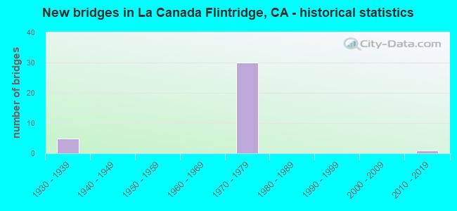
- New bridges - historical statistics
- 51930-1939
- 301970-1979
- 12010-2019

- Reconstructed bridges - Historical Statistics
- 11950-1959
- 11960-1969
- 01970-1979
- 21980-1989


- Bridge Condition - Deck
- 70.0%Good
- 30.0%Fair

- Bridge Condition - Superstructure
- 85.0%Good
- 15.0%Fair

- Bridge Condition - Channel
- 66.7%Excellent
- 16.7%Very good
- 16.7%Good
Find on map >> Show street view
Structure Number: 53 0061, Location: 07-LA-002-R25.51 (Lat: 34.219003, Lng: -118.196036), Route carried "on" structure: State highway 2, Year Built: 1930, Year Reconstructed: 1966, Status: Open, Structure Length: 4.66m (15.29ft), Average Daily Traffic: 6,600 (year 2014), Truck Traffic: 2%, Average Future Daily Traffic: 17,180 (year 2044), Design Load: HS 20, Features Intersected: LA CANADA CANYON
Minimum Vertical Clearance: 30+ m (98+ ft), Kilometerpoint: 25.510, Lanes on structure: 4, Base Highway Network: Yes (, Subroute: 1), Owner: State Highway Agency, Approaching Roadway Width: 17.1m (56.1ft), Skew: 9 degrees, Material/Design: Concrete, Design/Construction: Arch - Deck, Number Of Spans In Main Unit: 3, Length of Maximum Span: 29.3m (96.1ft), Curb or Sidewalk Widths: Left: 1.5m (4.9ft), Right: 1.5m (4.9ft), Curb-To-Curb Width: 17.1m (56.1ft), Out-to-Out Width: 20.7m (67.9ft)
Condition: Deck: Good, Superstructure: Good, Substructure: Good, Channel: Good, Operating Rating: 67.7 metric tons, Method Used To Determine Operating Rating: Load Factor (LF), Inventory Rating: 40.8 metric tons, Method Used To Determine Inventory Rating: Load Factor (LF), Structural Evaluation: Better than present minimum criteria, Deck Geometry: Somewhat better than minimum adequacy, Waterway Adequacy: Better than present minimum criteria, Approach Roadway Alignment: Better than present minimum criteria, Designated Inspection Frequency: Every 24 months, Inspection Date: January 2022, Deck Structure Type: Concrete Cast-file-Place
Find on map >> Show street view
Structure Number: 53 0734, Location: 07-LA-210-R21.53-LCF (Lat: 34.190250, Lng: -118.181197), Route carried "on" structure: Interstate 210, Year Built: 1974, Status: Open, Structure Length: 4.85m (15.91ft), Average Daily Traffic: 113,000 (year 2010), Truck Traffic: 10%, Average Future Daily Traffic: 129,673 (year 2038), Design Load: HS 20, Features Intersected: BERKSHIRE PL UC
Minimum Vertical Clearance: 30+ m (98+ ft), Kilometerpoint: 21.530, Lanes on structure: 8, Lanes under structure: 5, Base Highway Network: Yes (Inventory Route: 2, Subroute: 1), Owner: State Highway Agency, Approaching Roadway Width: 43.9m (144.0ft), Skew: 32 degrees, Material/Design: Prestressed concrete, Design/Construction: Box Beam or Girders - Multiple, Number Of Spans In Main Unit: 1, Length of Maximum Span: 48.5m (159.1ft), Curb-To-Curb Width: 43.9m (144.0ft), Out-to-Out Width: 45.1m (148.0ft)
Condition: Deck: Good, Superstructure: Fair, Substructure: Good, Operating Rating: 59.6 metric tons, Method Used To Determine Operating Rating: Load and Resistance Factor Rating (LRFR) rating reported by rating factor(RF) method using HL-93 loadings, Inventory Rating: 40.5 metric tons, Method Used To Determine Inventory Rating: Load and Resistance Factor Rating (LRFR) rating reported by rating factor(RF) method using HL-93 loadings, Structural Evaluation: Somewhat better than minimum adequacy, Deck Geometry: Superior to present desirable criteria, Underclear: Meets minimum limits, Approach Roadway Alignment: Equal to present desirable criteria, Designated Inspection Frequency: Every 24 months, Inspection Date: November 2021, Deck Structure Type: Concrete Cast-file-Place
Find on map >> Show street view
Structure Number: 53 2168, Location: 07-LA-210-R20.30-LCF (Lat: 34.204367, Lng: -118.193700), Route carried "on" structure: City street , Year Built: 1972, Status: Open, Structure Length: 8.50m (27.89ft), Average Daily Traffic: 6,520 (year 2010), Truck Traffic: 1%, Average Future Daily Traffic: 8,733 (year 2038), Design Load: HS 20, Features Intersected: ROUTE 210, Facility Carried by Structure: OAKWOOD AVE
Minimum Vertical Clearance: 30+ m (98+ ft), Kilometerpoint: 0.000, Lanes on structure: 2, Lanes under structure: 10, Owner: State Highway Agency, Approaching Roadway Width: 12.2m (40.0ft), Skew: 2 degrees, Material/Design: Prestressed concrete continuous, Design/Construction: Box Beam or Girders - Multiple, Number Of Spans In Main Unit: 2, Length of Maximum Span: 44.5m (146.0ft), Curb or Sidewalk Widths: Left: 2.1m (6.9ft), Right: 2.1m (6.9ft), Curb-To-Curb Width: 12.2m (40.0ft), Out-to-Out Width: 17.1m (56.1ft)
Condition: Deck: Fair, Superstructure: Good, Substructure: Good, Operating Rating: 40.5 metric tons, Method Used To Determine Operating Rating: Load and Resistance Factor Rating (LRFR) rating reported by rating factor(RF) method using HL-93 loadings, Inventory Rating: 24.3 metric tons, Method Used To Determine Inventory Rating: Load and Resistance Factor Rating (LRFR) rating reported by rating factor(RF) method using HL-93 loadings, Structural Evaluation: Equal to present minimum criteria, Deck Geometry: Somewhat better than minimum adequacy, Underclear: Equal to present minimum criteria, Approach Roadway Alignment: Equal to present desirable criteria, Designated Inspection Frequency: Every 24 months, Inspection Date: November 2021, Deck Structure Type: Concrete Cast-file-Place
Find on map >> Show street view
Structure Number: 53 2177, Location: 07-LA-210-R20.60-LCF (Lat: 34.202081, Lng: -118.189369), Route carried "on" structure: City street , Year Built: 1972, Status: Open, Structure Length: 9.14m (29.99ft), Average Daily Traffic: 8,600 (year 2010), Truck Traffic: 2%, Average Future Daily Traffic: 12,150 (year 2038), Design Load: HS 20, Features Intersected: I 210, Facility Carried by Structure: GOULD AVE
Minimum Vertical Clearance: 30+ m (98+ ft), Kilometerpoint: 0.000, Lanes on structure: 2, Lanes under structure: 8, Owner: State Highway Agency, Approaching Roadway Width: 19.5m (64.0ft), Skew: 4 degrees, Material/Design: Prestressed concrete continuous, Design/Construction: Box Beam or Girders - Multiple, Number Of Spans In Main Unit: 2, Length of Maximum Span: 46.3m (151.9ft), Curb or Sidewalk Widths: Left: 2.1m (6.9ft), Right: 2.1m (6.9ft), Curb-To-Curb Width: 19.5m (64.0ft), Out-to-Out Width: 24.4m (80.1ft)
Condition: Deck: Fair, Superstructure: Good, Substructure: Good, Operating Rating: 44.7 metric tons, Method Used To Determine Operating Rating: Load and Resistance Factor Rating (LRFR) rating reported by rating factor(RF) method using HL-93 loadings, Inventory Rating: 29.8 metric tons, Method Used To Determine Inventory Rating: Load and Resistance Factor Rating (LRFR) rating reported by rating factor(RF) method using HL-93 loadings, Structural Evaluation: Better than present minimum criteria, Deck Geometry: Superior to present desirable criteria, Underclear: Meets minimum limits, Approach Roadway Alignment: Equal to present desirable criteria, Designated Inspection Frequency: Every 24 months, Inspection Date: November 2021, Deck Structure Type: Concrete Cast-file-Place
Find on map >> Show street view
Structure Number: 53 2180K, Location: 07-LA-014-R30.66 (Lat: 34.406458, Lng: -118.463958), Route carried "on" structure: Bypass State highway 14, Year Built: 1972, Status: Open, Structure Length: 6.17m (20.24ft), Average Daily Traffic: 9,000 (year 2021), Truck Traffic: 3%, Average Future Daily Traffic: 11,332 (year 2041), Design Load: HS 20, Features Intersected: SIERRA HWY
Minimum Vertical Clearance: 30+ m (98+ ft), Kilometerpoint: 30.660, Lanes on structure: 2, Lanes under structure: 4, Base Highway Network: Yes (, Subroute: 1), Owner: State Highway Agency, Approaching Roadway Width: 11.0m (36.1ft), Skew: 3 degrees, Material/Design: Concrete continuous, Design/Construction: Box Beam or Girders - Multiple, Number Of Spans In Main Unit: 3, Length of Maximum Span: 37.6m (123.4ft), Curb-To-Curb Width: 11.0m (36.1ft), Out-to-Out Width: 11.6m (38.1ft)
Condition: Deck: Good, Superstructure: Good, Substructure: Good, Operating Rating: 51.8 metric tons, Method Used To Determine Operating Rating: Load and Resistance Factor Rating (LRFR) rating reported by rating factor(RF) method using HL-93 loadings, Inventory Rating: 37.3 metric tons, Method Used To Determine Inventory Rating: Load and Resistance Factor Rating (LRFR) rating reported by rating factor(RF) method using HL-93 loadings, Structural Evaluation: Better than present minimum criteria, Deck Geometry: Equal to present minimum criteria, Underclear: Meets minimum limits, Approach Roadway Alignment: Equal to present minimum criteria, Designated Inspection Frequency: Every 24 months, Inspection Date: January 2021, Deck Structure Type: Concrete Cast-file-Place
Find on map >> Show street view
Structure Number: 53 2189, Location: 07-LA-210-R19.23-LCF (Lat: 34.207867, Lng: -118.211642), Route carried "on" structure: City street Q265, Year Built: 1972, Status: Open, Structure Length: 14.33m (47.01ft), Average Daily Traffic: 3,500 (year 2012), Truck Traffic: 1%, Average Future Daily Traffic: 5,630 (year 2038), Design Load: HS 20, Features Intersected: ROUTE 210, Facility Carried by Structure: ALTA CANYADA RD
Minimum Vertical Clearance: 30+ m (98+ ft), Kilometerpoint: 0.000, Lanes on structure: 2, Lanes under structure: 12, Owner: State Highway Agency, Approaching Roadway Width: 12.2m (40.0ft), Material/Design: Prestressed concrete, Design/Construction: Box Beam or Girders - Multiple, Number Of Spans In Main Unit: 1, Number Of Approach Spans: 3, Length of Maximum Span: 48.5m (159.1ft), Curb or Sidewalk Widths: Left: 2.1m (6.9ft), Right: 2.1m (6.9ft), Curb-To-Curb Width: 12.2m (40.0ft), Out-to-Out Width: 17.1m (56.1ft)
Condition: Deck: Fair, Superstructure: Fair, Substructure: Good, Operating Rating: 97.8 metric tons, Method Used To Determine Operating Rating: Load Factor (LF), Inventory Rating: 32.4 metric tons, Method Used To Determine Inventory Rating: Load Factor (LF), Structural Evaluation: Somewhat better than minimum adequacy, Deck Geometry: Equal to present minimum criteria, Underclear: Equal to present minimum criteria, Approach Roadway Alignment: Equal to present desirable criteria, Designated Inspection Frequency: Every 24 months, Inspection Date: November 2021, Deck Structure Type: Concrete Cast-file-Place
Find on map >> Show street view
Structure Number: 53 2191G, Location: 07-LA-210-R18.76-LCF (Lat: 34.207944, Lng: -118.219147), Route carried "on" structure: Interstate 210, Year Built: 1972, Status: Open, Structure Length: 5.03m (16.50ft), Average Daily Traffic: 166,000 (year 2018), Truck Traffic: 6%, Average Future Daily Traffic: 160,105 (year 2041), Design Load: HS 20, Features Intersected: E2-W210 CONNECTOR RAMP
Minimum Vertical Clearance: 30+ m (98+ ft), Kilometerpoint: 18.760, Lanes on structure: 9, Lanes under structure: 3, Base Highway Network: Yes (Inventory Route: 2, Subroute: 1), Owner: State Highway Agency, Approaching Roadway Width: 47.5m (155.8ft), Skew: 36 degrees, Material/Design: Concrete, Design/Construction: Box Beam or Girders - Multiple, Number Of Spans In Main Unit: 1, Length of Maximum Span: 46.3m (151.9ft), Curb-To-Curb Width: 47.5m (155.8ft), Out-to-Out Width: 48.1m (157.8ft)
Condition: Deck: Good, Superstructure: Good, Substructure: Good, Operating Rating: 99.8 metric tons, Method Used To Determine Operating Rating: Load Factor (LF), Inventory Rating: 77.1 metric tons, Method Used To Determine Inventory Rating: Load Factor (LF), Structural Evaluation: Better than present minimum criteria, Deck Geometry: Superior to present desirable criteria, Underclear: Superior to present desirable criteria, Approach Roadway Alignment: Equal to present desirable criteria, Length Of Structure Improvement: 5.18m (16.99ft), Designated Inspection Frequency: Every 24 months, Inspection Date: September 2020, Deck Structure Type: Concrete Cast-file-Place
Find on map >> Show street view
Structure Number: 53 2198, Location: 07-LA-210-R22.02-LCF (Lat: 34.184786, Lng: -118.176086), Route carried "on" structure: City street Q296, Year Built: 1974, Status: Open, Structure Length: 6.80m (22.31ft), Average Daily Traffic: 6,500 (year 2010), Truck Traffic: 8%, Average Future Daily Traffic: 8,700 (year 2038), Design Load: HS 20, Features Intersected: ROUTE 210, Facility Carried by Structure: LINDA VISTA AVE
Minimum Vertical Clearance: 30+ m (98+ ft), Kilometerpoint: 0.000, Lanes on structure: 4, Lanes under structure: 8, Base Highway Network: Yes, Owner: State Highway Agency, Approaching Roadway Width: 15.8m (51.8ft), Material/Design: Concrete continuous, Design/Construction: Box Beam or Girders - Multiple, Number Of Spans In Main Unit: 2, Length of Maximum Span: 35.4m (116.1ft), Curb or Sidewalk Widths: Left: 0.6m (2.0ft), Right: 2.1m (6.9ft), Curb-To-Curb Width: 15.8m (51.8ft), Out-to-Out Width: 19.2m (63.0ft)
Condition: Deck: Good, Superstructure: Fair, Substructure: Good, Operating Rating: 66.4 metric tons, Method Used To Determine Operating Rating: Load and Resistance Factor Rating (LRFR) rating reported by rating factor(RF) method using HL-93 loadings, Inventory Rating: 51.2 metric tons, Method Used To Determine Inventory Rating: Load and Resistance Factor Rating (LRFR) rating reported by rating factor(RF) method using HL-93 loadings, Structural Evaluation: Somewhat better than minimum adequacy, Deck Geometry: Meets minimum limits, Underclear: Meets minimum limits, Approach Roadway Alignment: Superior to present desirable criteria, Designated Inspection Frequency: Every 24 months, Inspection Date: November 2021, Deck Structure Type: Concrete Cast-file-Place
Find on map >> Show street view
Structure Number: 53 2199, Location: 07-LA-210-R18.91-LCF (Lat: 34.207300, Lng: -118.217303), Route carried "on" structure: Interstate 210, Year Built: 1972, Status: Open, Structure Length: 5.39m (17.68ft), Average Daily Traffic: 116,000 (year 2017), Truck Traffic: 10%, Average Future Daily Traffic: 132,779 (year 2041), Design Load: HS 20, Features Intersected: W210-W2 CONNECTOR RAMP
Minimum Vertical Clearance: 30+ m (98+ ft), Kilometerpoint: 18.910, Lanes on structure: 8, Lanes under structure: 2, Base Highway Network: Yes (Inventory Route: 2, Subroute: 1), Owner: State Highway Agency, Approaching Roadway Width: 43.9m (144.0ft), Skew: 35 degrees, Material/Design: Prestressed concrete, Design/Construction: Box Beam or Girders - Multiple, Number Of Spans In Main Unit: 1, Length of Maximum Span: 53.1m (174.2ft), Curb-To-Curb Width: 43.9m (144.0ft), Out-to-Out Width: 45.1m (148.0ft)
Condition: Deck: Good, Superstructure: Good, Substructure: Good, Operating Rating: 96.9 metric tons, Method Used To Determine Operating Rating: Load Factor (LF), Inventory Rating: 32.4 metric tons, Method Used To Determine Inventory Rating: Load Factor (LF), Structural Evaluation: Better than present minimum criteria, Deck Geometry: Superior to present desirable criteria, Underclear: Equal to present desirable criteria, Approach Roadway Alignment: Equal to present desirable criteria, Designated Inspection Frequency: Every 24 months, Inspection Date: September 2020, Deck Structure Type: Concrete Cast-file-Place
Find on map >> Show street view
Structure Number: 53 2200S, Location: 07-LA-014-R30.81 (Lat: 34.400897, Lng: -118.456839), Route carried "on" structure: Bypass State highway 14, Year Built: 1972, Status: Open, Structure Length: 46.39m (152.20ft), Average Daily Traffic: 12,000 (year 2021), Truck Traffic: 2%, Average Future Daily Traffic: 18,531 (year 2041), Design Load: HS 20, Features Intersected: ROUTE 14 & VIA PRINCESSA, Facility Carried by Structure: SIERRA HWY OFF-RAM
Minimum Vertical Clearance: 30+ m (98+ ft), Kilometerpoint: 30.810, Lanes on structure: 2, Lanes under structure: 16, Base Highway Network: Yes (, Subroute: 1), Owner: State Highway Agency, Approaching Roadway Width: 11.9m (39.0ft), Skew: 9 degrees, Material/Design: Prestressed concrete continuous, Design/Construction: Box Beam or Girders - Multiple, Number Of Spans In Main Unit: 12, Length of Maximum Span: 57.9m (190.0ft), Curb-To-Curb Width: 11.9m (39.0ft), Out-to-Out Width: 12.5m (41.0ft)
Condition: Deck: Good, Superstructure: Good, Substructure: Good, Operating Rating: 25.9 metric tons, Method Used To Determine Operating Rating: Load and Resistance Factor Rating (LRFR) rating reported by rating factor(RF) method using HL-93 loadings, Inventory Rating: 18.5 metric tons, Method Used To Determine Inventory Rating: Load and Resistance Factor Rating (LRFR) rating reported by rating factor(RF) method using HL-93 loadings, Structural Evaluation: Meets minimum limits, Deck Geometry: Better than present minimum criteria, Underclear: Superior to present desirable criteria, Approach Roadway Alignment: Equal to present desirable criteria, Designated Inspection Frequency: Every 24 months, Inspection Date: January 2021, Deck Structure Type: Concrete Cast-file-Place
Find on map >> Show street view
Structure Number: 53 2202, Location: 07-LA-210-R20.85-LCF (Lat: 34.198450, Lng: -118.186575), Route carried "on" structure: Interstate 210, Year Built: 1972, Status: Open, Structure Length: 20.21m (66.31ft), Average Daily Traffic: 113,000 (year 2012), Truck Traffic: 10%, Average Future Daily Traffic: 129,673 (year 2038), Design Load: HS 20, Features Intersected: HAMPTON RD & FOOTHILL BL
Minimum Vertical Clearance: 30+ m (98+ ft), Kilometerpoint: 20.850, Lanes on structure: 8, Lanes under structure: 7, Base Highway Network: Yes (Inventory Route: 2, Subroute: 1), Owner: State Highway Agency, Approaching Roadway Width: 43.9m (144.0ft), Skew: 33 degrees, Material/Design: Concrete continuous, Design/Construction: Box Beam or Girders - Multiple, Number Of Spans In Main Unit: 12, Length of Maximum Span: 43.0m (141.1ft), Curb-To-Curb Width: 43.9m (144.0ft), Out-to-Out Width: 45.1m (148.0ft)
Condition: Deck: Fair, Superstructure: Good, Substructure: Good, Operating Rating: 31.4 metric tons, Method Used To Determine Operating Rating: Load and Resistance Factor Rating (LRFR) rating reported by rating factor(RF) method using HL-93 loadings, Inventory Rating: 22.4 metric tons, Method Used To Determine Inventory Rating: Load and Resistance Factor Rating (LRFR) rating reported by rating factor(RF) method using HL-93 loadings, Structural Evaluation: Somewhat better than minimum adequacy, Deck Geometry: Superior to present desirable criteria, Underclear: Equal to present minimum criteria, Approach Roadway Alignment: Equal to present desirable criteria, Designated Inspection Frequency: Every 24 months, Inspection Date: November 2021, Deck Structure Type: Concrete Cast-file-Place
Find on map >> Show street view
Structure Number: 53 2210G, Location: 07-LA-118-R9.70-LA (Lat: 34.264392, Lng: -118.473156), Route carried "on" structure: Ramp State highway 118, Year Built: 1977, Status: Open, Structure Length: 5.46m (17.91ft), Average Daily Traffic: 24,600 (year 2020), Truck Traffic: 2%, Average Future Daily Traffic: 30,100 (year 2040), Design Load: HS 20, Features Intersected: CHATSWORTH STREET
Minimum Vertical Clearance: 30+ m (98+ ft), Kilometerpoint: 9.700, Lanes on structure: 2, Lanes under structure: 4, Base Highway Network: Yes (Inventory Route: 1, Subroute: 1), Owner: State Highway Agency, Approaching Roadway Width: 11.8m (38.7ft), Skew: 9 degrees, Material/Design: Prestressed concrete, Design/Construction: Box Beam or Girders - Multiple, Number Of Spans In Main Unit: 1, Length of Maximum Span: 53.6m (175.9ft), Curb-To-Curb Width: 11.8m (38.7ft), Out-to-Out Width: 12.8m (42.0ft)
Condition: Deck: Good, Superstructure: Good, Substructure: Good, Operating Rating: 94.3 metric tons, Method Used To Determine Operating Rating: Load Factor (LF), Inventory Rating: 32.4 metric tons, Method Used To Determine Inventory Rating: Load Factor (LF), Structural Evaluation: Better than present minimum criteria, Deck Geometry: Superior to present desirable criteria, Underclear: Equal to present minimum criteria, Approach Roadway Alignment: Equal to present desirable criteria, Designated Inspection Frequency: Every 24 months, Inspection Date: Febuary 2022, Deck Structure Type: Concrete Cast-file-Place
Find on map >> Show street view
Structure Number: 53 2218, Location: 07-LA-210-R20.16-LCF (Lat: 34.205425, Lng: -118.195894), Route carried "on" structure: City street , Year Built: 1972, Status: Open, Structure Length: 8.84m (29.00ft), Average Daily Traffic: 2,240 (year 2010), Truck Traffic: 1%, Average Future Daily Traffic: 3,582 (year 2038), Design Load: HS 20, Features Intersected: ROUTE 210, Facility Carried by Structure: COMMONWEALTH AVE
Minimum Vertical Clearance: 30+ m (98+ ft), Kilometerpoint: 0.000, Lanes on structure: 2, Lanes under structure: 10, Owner: State Highway Agency, Approaching Roadway Width: 12.2m (40.0ft), Skew: 2 degrees, Material/Design: Prestressed concrete continuous, Design/Construction: Box Beam or Girders - Multiple, Number Of Spans In Main Unit: 2, Length of Maximum Span: 49.4m (162.1ft), Curb or Sidewalk Widths: Left: 2.1m (6.9ft), Right: 2.1m (6.9ft), Curb-To-Curb Width: 12.2m (40.0ft), Out-to-Out Width: 17.1m (56.1ft)
Condition: Deck: Good, Superstructure: Good, Substructure: Good, Operating Rating: 29.8 metric tons, Method Used To Determine Operating Rating: Load and Resistance Factor Rating (LRFR) rating reported by rating factor(RF) method using HL-93 loadings, Inventory Rating: 18.8 metric tons, Method Used To Determine Inventory Rating: Load and Resistance Factor Rating (LRFR) rating reported by rating factor(RF) method using HL-93 loadings, Structural Evaluation: Somewhat better than minimum adequacy, Deck Geometry: Equal to present minimum criteria, Underclear: High priority of corrective action, Approach Roadway Alignment: Equal to present desirable criteria, Designated Inspection Frequency: Every 24 months, Inspection Date: November 2021, Deck Structure Type: Concrete Cast-file-Place
Find on map >> Show street view
Structure Number: 53 2219G, Location: 07-LA-210-R18.53-LCF (Lat: 34.209475, Lng: -118.223656), Route carried "on" structure: Ramp Interstate 210, Year Built: 1972, Year Reconstructed: 1994, Status: Open, Structure Length: 15.71m (51.54ft), Average Daily Traffic: 26,100 (year 2018), Truck Traffic: 4%, Average Future Daily Traffic: 35,377 (year 2041), Design Load: HS 20, Features Intersected: WALTONIA DR
Minimum Vertical Clearance: 30+ m (98+ ft), Kilometerpoint: 18.530, Lanes on structure: 3, Lanes under structure: 3, Base Highway Network: Yes (Inventory Route: 2, Subroute: 1), Owner: State Highway Agency, Approaching Roadway Width: 15.5m (50.9ft), Skew: 3 degrees, Material/Design: Prestressed concrete continuous, Design/Construction: Box Beam or Girders - Multiple, Number Of Spans In Main Unit: 2, Number Of Approach Spans: 2, Length of Maximum Span: 46.5m (152.6ft), Curb-To-Curb Width: 15.5m (50.9ft), Out-to-Out Width: 16.2m (53.1ft)
Condition: Deck: Good, Superstructure: Good, Substructure: Good, Operating Rating: 99.8 metric tons, Method Used To Determine Operating Rating: Load Factor (LF), Inventory Rating: 32.4 metric tons, Method Used To Determine Inventory Rating: Load Factor (LF), Structural Evaluation: Better than present minimum criteria, Deck Geometry: Superior to present desirable criteria, Underclear: Better than present minimum criteria, Approach Roadway Alignment: Equal to present desirable criteria, Designated Inspection Frequency: Every 24 months, Inspection Date: September 2020, Deck Structure Type: Concrete Cast-file-Place
Find on map >> Show street view
Structure Number: 53 2219K, Location: 07-LA-210-R18.53-LCF (Lat: 34.211283, Lng: -118.224967), Route carried "on" structure: Ramp Interstate 210, Year Built: 1972, Year Reconstructed: 1994, Status: Open, Structure Length: 27.86m (91.40ft), Average Daily Traffic: 5,600 (year 2018), Truck Traffic: 2%, Average Future Daily Traffic: 6,946 (year 2041), Design Load: HS 20, Features Intersected: WALTONIA DR
Minimum Vertical Clearance: 30+ m (98+ ft), Kilometerpoint: 18.530, Lanes on structure: 1, Lanes under structure: 4, Base Highway Network: Yes (Inventory Route: 2, Subroute: 1), Owner: State Highway Agency, Approaching Roadway Width: 7.3m (24.0ft), Material/Design: Prestressed concrete continuous, Design/Construction: Box Beam or Girders - Multiple, Number Of Spans In Main Unit: 2, Number Of Approach Spans: 5, Length of Maximum Span: 57.9m (190.0ft), Curb-To-Curb Width: 7.3m (24.0ft), Out-to-Out Width: 7.9m (25.9ft)
Condition: Deck: Good, Superstructure: Good, Substructure: Good, Operating Rating: 75.8 metric tons, Method Used To Determine Operating Rating: Load Factor (LF), Inventory Rating: 32.4 metric tons, Method Used To Determine Inventory Rating: Load Factor (LF), Structural Evaluation: Better than present minimum criteria, Deck Geometry: Better than present minimum criteria, Underclear: Superior to present desirable criteria, Approach Roadway Alignment: Equal to present desirable criteria, Designated Inspection Frequency: Every 24 months, Inspection Date: September 2020, Deck Structure Type: Concrete Cast-file-Place
Find on map >> Show street view
Structure Number: 53 2228G, Location: 07-LA-002-R23.15-LCF (Lat: 34.210297, Lng: -118.223311), Route carried "on" structure: Ramp State highway 2, Year Built: 1972, Status: Open, Structure Length: 6.50m (21.33ft), Average Daily Traffic: 27,400 (year 2014), Truck Traffic: 5%, Average Future Daily Traffic: 38,325 (year 2044), Design Load: HS 20, Features Intersected: WALTONIA DR
Minimum Vertical Clearance: 30+ m (98+ ft), Kilometerpoint: 23.150, Lanes on structure: 3, Lanes under structure: 2, Base Highway Network: Yes (, Subroute: 1), Owner: State Highway Agency, Approaching Roadway Width: 15.5m (50.9ft), Skew: 4 degrees, Material/Design: Concrete continuous, Design/Construction: Box Beam or Girders - Multiple, Number Of Spans In Main Unit: 3, Length of Maximum Span: 32.3m (106.0ft), Curb-To-Curb Width: 15.5m (50.9ft), Out-to-Out Width: 16.2m (53.1ft)
Condition: Deck: Fair, Superstructure: Good, Substructure: Good, Operating Rating: 37.3 metric tons, Method Used To Determine Operating Rating: Load and Resistance Factor Rating (LRFR) rating reported by rating factor(RF) method using HL-93 loadings, Inventory Rating: 28.5 metric tons, Method Used To Determine Inventory Rating: Load and Resistance Factor Rating (LRFR) rating reported by rating factor(RF) method using HL-93 loadings, Structural Evaluation: Better than present minimum criteria, Deck Geometry: Superior to present desirable criteria, Underclear: Equal to present desirable criteria, Approach Roadway Alignment: Superior to present desirable criteria, Designated Inspection Frequency: Every 24 months, Inspection Date: January 2022, Deck Structure Type: Concrete Cast-file-Place
Find on map >> Show street view
Structure Number: 53C1464, Location: 0.1MI N/O FOOTHILL BLVD (Lat: 34.217156, Lng: -118.225222), Route carried "on" structure: City street Q247, Year Built: 1936, Status: Open, Structure Length: 2.04m (6.69ft), Average Daily Traffic: 3,366 (year 2012), Truck Traffic: 1%, Average Future Daily Traffic: 3,703 (year 2040), Design Load: H 20, Features Intersected: HALLS CYN CHAN, Facility Carried by Structure: CASTLE RD
Minimum Vertical Clearance: 30.47m (99.97ft), Kilometerpoint: 0.000, Lanes on structure: 2, Owner: City or Municipal Highway Agency, Approaching Roadway Width: 12.2m (40.0ft), Skew: 6 degrees, Design/Construction: Slab, Number Of Spans In Main Unit: 1, Length of Maximum Span: 6.1m (20.0ft), Curb or Sidewalk Widths: Left: 1.2m (3.9ft), Right: 0.2m (0.7ft), Curb-To-Curb Width: 12.3m (40.4ft), Out-to-Out Width: 20.0m (65.6ft)
Condition: Deck: Good, Superstructure: Good, Substructure: Good, Channel: Excellent, Operating Rating: 55.7 metric tons, Method Used To Determine Operating Rating: Load Factor (LF), Inventory Rating: 33.4 metric tons, Method Used To Determine Inventory Rating: Load Factor (LF), Structural Evaluation: Better than present minimum criteria, Deck Geometry: Equal to present minimum criteria, Waterway Adequacy: Superior to present desirable criteria, Approach Roadway Alignment: Equal to present minimum criteria, Designated Inspection Frequency: Every 48 months, Inspection Date: September 2020, Deck Structure Type: Concrete Cast-file-Place, Wearing Surface/Protective System: Wearing Surface: Bituminous
Find on map >> Show street view
Structure Number: 53C1465, Location: 0.1MI E/O CASTLE RD (Lat: 34.218544, Lng: -118.224622), Route carried "on" structure: City street , Year Built: 1936, Status: Open, Structure Length: 0.70m (2.30ft), Average Daily Traffic: 1,479 (year 2012), Truck Traffic: 2%, Average Future Daily Traffic: 1,627 (year 2040), Design Load: H 20, Features Intersected: HALLS CYN CHAN, Facility Carried by Structure: LYANS DR
Minimum Vertical Clearance: 30.47m (99.97ft), Kilometerpoint: 0.000, Lanes on structure: 2, Owner: City or Municipal Highway Agency, Approaching Roadway Width: 9.1m (29.9ft), Skew: 2 degrees, Material/Design: Concrete, Design/Construction: Slab, Number Of Spans In Main Unit: 1, Length of Maximum Span: 6.1m (20.0ft), Curb-To-Curb Width: 9.1m (29.9ft), Out-to-Out Width: 14.1m (46.3ft)
Condition: Deck: Good, Superstructure: Good, Substructure: Good, Channel: Excellent, Operating Rating: 57.7 metric tons, Method Used To Determine Operating Rating: Load Factor (LF), Inventory Rating: 34.7 metric tons, Method Used To Determine Inventory Rating: Load Factor (LF), Structural Evaluation: Better than present minimum criteria, Deck Geometry: Somewhat better than minimum adequacy, Waterway Adequacy: Superior to present desirable criteria, Approach Roadway Alignment: Equal to present minimum criteria, Designated Inspection Frequency: Every 48 months, Inspection Date: September 2020, Deck Structure Type: Concrete Cast-file-Place, Wearing Surface/Protective System: Wearing Surface: Bituminous
Find on map >> Show street view
Structure Number: 53C1466, Location: 0.3MI E/O OCEAN BLVD (Lat: 34.221289, Lng: -118.223125), Route carried "on" structure: City street , Year Built: 1936, Status: Open, Structure Length: 0.76m (2.49ft), Average Daily Traffic: 357 (year 2012), Truck Traffic: 1%, Average Future Daily Traffic: 357 (year 2040), Design Load: H 20, Features Intersected: HALLS BECKLEY CYN CHAN, Facility Carried by Structure: CROSS ST
Minimum Vertical Clearance: 30.47m (99.97ft), Kilometerpoint: 0.000, Lanes on structure: 2, Owner: City or Municipal Highway Agency, Approaching Roadway Width: 9.4m (30.8ft), Skew: 2 degrees, Material/Design: Concrete, Design/Construction: Slab, Number Of Spans In Main Unit: 1, Length of Maximum Span: 6.1m (20.0ft), Curb or Sidewalk Widths: Left: 1.6m (5.2ft), Right: 0.0m, Curb-To-Curb Width: 9.4m (30.8ft), Out-to-Out Width: 32.0m (105.0ft)
Condition: Deck: Good, Superstructure: Good, Substructure: Good, Channel: Excellent, Operating Rating: 45.4 metric tons, Method Used To Determine Operating Rating: Load Factor (LF), Inventory Rating: 27.2 metric tons, Method Used To Determine Inventory Rating: Load Factor (LF), Structural Evaluation: Equal to present minimum criteria, Deck Geometry: Equal to present minimum criteria, Waterway Adequacy: Superior to present desirable criteria, Approach Roadway Alignment: Equal to present desirable criteria, Designated Inspection Frequency: Every 24 months, Inspection Date: September 2020, Deck Structure Type: Concrete Cast-file-Place, Wearing Surface/Protective System: Wearing Surface: Bituminous
Find on map >> Show street view
Structure Number: 53C1813, Location: 0.1MI W/O CASTLE RD (Lat: 34.216425, Lng: -118.225533), Route carried "on" structure: City street L594, Year Built: 1935, Year Reconstructed: 1955, Status: Open, Structure Length: 0.67m (2.20ft), Average Daily Traffic: 24,289 (year 2012), Truck Traffic: 2%, Average Future Daily Traffic: 29,147 (year 2040), Features Intersected: HALLS BECKLEY CYN CH, Facility Carried by Structure: FOOTHILL BLVD
Minimum Vertical Clearance: 30.47m (99.97ft), Kilometerpoint: 0.000, Lanes on structure: 4, Owner: City or Municipal Highway Agency, Approaching Roadway Width: 24.4m (80.1ft), Skew: 20 degrees, Material/Design: Concrete, Design/Construction: Culvert, Number Of Spans In Main Unit: 1, Length of Maximum Span: 6.4m (21.0ft), Curb or Sidewalk Widths: Left: 2.9m (9.5ft), Right: 2.5m (8.2ft), Curb-To-Curb Width: 19.3m (63.3ft), Out-to-Out Width: 30.5m (100.1ft)
Condition: Channel: Excellent, Culverts: Very good, Operating Rating: 40.5 metric tons, Method Used To Determine Operating Rating: Field evaluation and documented engineering judgment, Inventory Rating: 24.3 metric tons, Method Used To Determine Inventory Rating: Field evaluation and documented engineering judgment, Structural Evaluation: Equal to present minimum criteria, Deck Geometry: Equal to present minimum criteria, Waterway Adequacy: Superior to present desirable criteria, Approach Roadway Alignment: Equal to present desirable criteria, Designated Inspection Frequency: Every 24 months, Inspection Date: September 2020
Find on map >> Show street view
Structure Number: 53C2298, Location: 0.1MI W/O PALM DR (Lat: 34.224503, Lng: -118.218319), Route carried "on" structure: City street , Year Built: 2013, Status: Open, Structure Length: 2.13m (6.99ft), Average Daily Traffic: 1,450 (year 2012), Truck Traffic: 2%, Average Future Daily Traffic: 1,595 (year 2041), Design Load: HS 20+Mod, Features Intersected: EARLE CYN, Facility Carried by Structure: JESSEN DR
Minimum Vertical Clearance: 30+ m (98+ ft), Kilometerpoint: 0.000, Lanes on structure: 2, Owner: City or Municipal Highway Agency, Approaching Roadway Width: 7.6m (24.9ft), Material/Design: Prestressed concrete, Design/Construction: Stringer/Multi-beam, Number Of Spans In Main Unit: 1, Length of Maximum Span: 19.0m (62.3ft), Curb or Sidewalk Widths: Left: 0.0m, Right: 1.5m (4.9ft), Curb-To-Curb Width: 9.8m (32.2ft), Out-to-Out Width: 12.1m (39.7ft)
Condition: Deck: Fair, Superstructure: Good, Substructure: Good, Channel: Very good, Operating Rating: 65.8 metric tons, Method Used To Determine Operating Rating: Load Factor (LF), Inventory Rating: 38.9 metric tons, Method Used To Determine Inventory Rating: Load Factor (LF), Structural Evaluation: Better than present minimum criteria, Deck Geometry: Somewhat better than minimum adequacy, Waterway Adequacy: Superior to present desirable criteria, Approach Roadway Alignment: Equal to present desirable criteria, Designated Inspection Frequency: Every 24 months, Inspection Date: March 2021, Deck Structure Type: Concrete Cast-file-Place, Wearing Surface/Protective System: Wearing Surface: Monolithic Concrete
Find on map >> Show street view
Structure Number: 53 0734, Location: 07-LA-210-R21.53-LCF (Lat: 34.190250, Lng: -118.181197), Route carried "under" structure: City street , Year Built: 1974, Structure Length: 0. m, Average Daily Traffic: 9,500 (year 2010), Truck Traffic: 7%, Features Intersected: BERKSHIRE PL UC, Facility Carried by Structure: INTERSTATE 210
Minimum Vertical Clearance: 5.69m (18.67ft), Kilometerpoint: 21.530, Lanes on structure: 8, Lanes under structure: 5, Material/Design: Prestressed concrete, Design/Construction: Box Beam or Girders - Multiple, Length of Maximum Span: 48.5m (159.1ft)
Find on map >> Show street view
Structure Number: 53 2168, Location: 07-LA-210-R20.30-LCF (Lat: 34.204367, Lng: -118.193700), Route carried "under" structure: Interstate 210, Year Built: 1972, Structure Length: 0. m, Average Daily Traffic: 113,000 (year 2010), Truck Traffic: 10%, Features Intersected: ROUTE 210, Facility Carried by Structure: OAKWOOD AVE
Minimum Vertical Clearance: 5.44m (17.85ft), Kilometerpoint: 20.300, Lanes on structure: 2, Lanes under structure: 10, Material/Design: Prestressed concrete continuous, Design/Construction: Box Beam or Girders - Multiple, Length of Maximum Span: 44.5m (146.0ft)
Find on map >> Show street view
Structure Number: 53 2177, Location: 07-LA-210-R20.60-LCF (Lat: 34.202081, Lng: -118.189369), Route carried "under" structure: Interstate 210, Year Built: 1972, Structure Length: 0. m, Average Daily Traffic: 113,000 (year 2010), Truck Traffic: 10%, Features Intersected: I 210, Facility Carried by Structure: GOULD AVE
Minimum Vertical Clearance: 5.18m (16.99ft), Kilometerpoint: 20.600, Lanes on structure: 2, Lanes under structure: 8, Material/Design: Prestressed concrete continuous, Design/Construction: Box Beam or Girders - Multiple, Length of Maximum Span: 46.3m (151.9ft)
Find on map >> Show street view
Structure Number: 53 2189, Location: 07-LA-210-R19.23-LCF (Lat: 34.207867, Lng: -118.211642), Route carried "under" structure: Interstate 210, Year Built: 1972, Structure Length: 0. m, Average Daily Traffic: 116,000 (year 2012), Truck Traffic: 10%, Features Intersected: ROUTE 210, Facility Carried by Structure: ALTA CANYADA RD
Minimum Vertical Clearance: 5.56m (18.24ft), Kilometerpoint: 19.230, Lanes on structure: 2, Lanes under structure: 12, Material/Design: Prestressed concrete, Design/Construction: Box Beam or Girders - Multiple, Length of Maximum Span: 48.5m (159.1ft)
Find on map >> Show street view
Structure Number: 53 219, Location: 07-LA-210-R19.31-LCF (Lat: 34.207672, Lng: -118.210100), Route carried "under" structure: Interstate 210, Year Built: 1972, Structure Length: 0. m, Average Daily Traffic: 116,000 (year 2009), Truck Traffic: 10%, Features Intersected: ROUTE 210, Facility Carried by Structure: WINERY CYN FLUME O
Minimum Vertical Clearance: 5.53m (18.14ft), Kilometerpoint: 19.310, Lanes under structure: 11, Material/Design: Concrete continuous, Design/Construction: Box Beam or Girders - Multiple, Length of Maximum Span: 45.1m (148.0ft)
Find on map >> Show street view
Structure Number: 53 2191G, Location: 07-LA-210-R18.76-LCF (Lat: 34.207944, Lng: -118.219147), Route carried "under" structure: Ramp State highway 2, Year Built: 1972, Structure Length: 0. m, Average Daily Traffic: 27,400 (year 2017), Truck Traffic: 2%, Features Intersected: E2-W210 CONNECTOR RAMP
Minimum Vertical Clearance: 5.41m (17.75ft), Kilometerpoint: 23.150, Lanes on structure: 9, Lanes under structure: 3, Material/Design: Concrete, Design/Construction: Box Beam or Girders - Multiple, Length of Maximum Span: 46.3m (151.9ft)
Find on map >> Show street view
Structure Number: 53 2198, Location: 07-LA-210-R22.02-LCF (Lat: 34.184786, Lng: -118.176086), Route carried "under" structure: Interstate 210, Year Built: 1974, Structure Length: 0. m, Average Daily Traffic: 113,000 (year 2010), Truck Traffic: 10%, Features Intersected: ROUTE 210, Facility Carried by Structure: LINDA VISTA AVE
Minimum Vertical Clearance: 5.38m (17.65ft), Kilometerpoint: 22.020, Lanes on structure: 4, Lanes under structure: 8, Material/Design: Concrete continuous, Design/Construction: Box Beam or Girders - Multiple, Length of Maximum Span: 35.4m (116.1ft)
Find on map >> Show street view
Structure Number: 53 2199, Location: 07-LA-210-R18.91-LCF (Lat: 34.207300, Lng: -118.217303), Route carried "under" structure: Ramp Interstate 210, Year Built: 1972, Structure Length: 0. m, Average Daily Traffic: 94,400 (year 2017), Truck Traffic: 8%, Features Intersected: W210-W2 CONNECTOR RAMP
Minimum Vertical Clearance: 5.21m (17.09ft), Kilometerpoint: 18.910, Lanes on structure: 8, Lanes under structure: 2, Material/Design: Prestressed concrete, Design/Construction: Box Beam or Girders - Multiple, Length of Maximum Span: 53.1m (174.2ft)
Find on map >> Show street view
Structure Number: 53 2202, Location: 07-LA-210-R20.85-LCF (Lat: 34.198450, Lng: -118.186575), Route carried "under" structure: City street , Year Built: 1972, Structure Length: 0. m, Average Daily Traffic: 35,000 (year 2012), Truck Traffic: 7%, Features Intersected: HAMPTON RD & FOOTHILL BL, Facility Carried by Structure: INTERSTATE 210
Minimum Vertical Clearance: 5.64m (18.50ft), Kilometerpoint: 20.850, Lanes on structure: 8, Lanes under structure: 5, Material/Design: Concrete continuous, Design/Construction: Box Beam or Girders - Multiple, Length of Maximum Span: 43.0m (141.1ft)
Find on map >> Show street view
Structure Number: 53 2202, Location: 07-LA-210-R20.85-LCF (Lat: 34.198450, Lng: -118.186575), Route carried "under" structure: City street , Year Built: 1972, Structure Length: 0. m, Average Daily Traffic: 19,500 (year 2012), Truck Traffic: 2%, Features Intersected: HAMPTON RD & FOOTHILL BL, Facility Carried by Structure: INTERSTATE 210
Minimum Vertical Clearance: 5.26m (17.26ft), Kilometerpoint: 20.850, Lanes on structure: 8, Lanes under structure: 2, Material/Design: Concrete continuous, Design/Construction: Box Beam or Girders - Multiple, Length of Maximum Span: 43.0m (141.1ft)
Find on map >> Show street view
Structure Number: 53 2218, Location: 07-LA-210-R20.16-LCF (Lat: 34.205425, Lng: -118.195894), Route carried "under" structure: Interstate 210, Year Built: 1972, Structure Length: 0. m, Average Daily Traffic: 113,000 (year 2010), Truck Traffic: 10%, Features Intersected: ROUTE 210, Facility Carried by Structure: COMMONWEALTH AVE
Minimum Vertical Clearance: 5.23m (17.16ft), Kilometerpoint: 20.160, Lanes on structure: 2, Lanes under structure: 10, Material/Design: Prestressed concrete continuous, Design/Construction: Box Beam or Girders - Multiple, Length of Maximum Span: 49.4m (162.1ft)
Find on map >> Show street view
Structure Number: 53 2219G, Location: 07-LA-210-R18.53-LCF (Lat: 34.209475, Lng: -118.223656), Route carried "under" structure: Ramp Interstate 210, Year Built: 1972, Structure Length: 0. m, Average Daily Traffic: 7,000 (year 2017), Truck Traffic: 1%, Features Intersected: WALTONIA DR
Minimum Vertical Clearance: 5.18m (16.99ft), Kilometerpoint: 18.530, Lanes on structure: 3, Lanes under structure: 1, Toll: On toll road, Material/Design: Prestressed concrete continuous, Design/Construction: Box Beam or Girders - Multiple, Length of Maximum Span: 46.5m (152.6ft)
Find on map >> Show street view
Structure Number: 53 2219K, Location: 07-LA-210-R18.53-LCF (Lat: 34.211283, Lng: -118.224967), Route carried "under" structure: Ramp Interstate 210, Year Built: 1972, Structure Length: 0. m, Average Daily Traffic: 9,000 (year 2017), Truck Traffic: 2%, Features Intersected: WALTONIA DR
Minimum Vertical Clearance: 5.31m (17.42ft), Kilometerpoint: 18.530, Lanes on structure: 1, Lanes under structure: 2, Material/Design: Prestressed concrete continuous, Design/Construction: Box Beam or Girders - Multiple, Length of Maximum Span: 57.9m (190.0ft)
Find on map >> Show street view
Structure Number: 53 223, Location: 07-LA-002-24.43 (Lat: 34.206222, Lng: -118.200019), Route carried "under" structure: Interstate 210, Year Built: 1972, Structure Length: 0. m, Average Daily Traffic: 117,000 (year 2012), Truck Traffic: 7%, Features Intersected: ROUTE 210, Facility Carried by Structure: ROUTE 2 ANGELS CRE
Minimum Vertical Clearance: 6.19m (20.31ft), Kilometerpoint: 19.880, Lanes on structure: 4, Lanes under structure: 10, Material/Design: Prestressed concrete continuous, Design/Construction: Box Beam or Girders - Multiple, Length of Maximum Span: 47.5m (155.8ft)
Find on map >> Show street view
Structure Number: 53 2232, Location: 07-LA-210-R21.12-LCF (Lat: 34.196014, Lng: -118.183064), Route carried "under" structure: Interstate 210, Year Built: 1974, Structure Length: 0. m, Average Daily Traffic: 113,000 (year 2009), Truck Traffic: 10%, Features Intersected: INTERSTATE 210, Facility Carried by Structure: PEDESTRIAN WALKWAY
Minimum Vertical Clearance: 5.61m (18.41ft), Kilometerpoint: 21.120, Lanes under structure: 10, Material/Design: Prestressed concrete continuous, Design/Construction: Box Beam or Girders - Multiple, Length of Maximum Span: 44.2m (145.0ft)