Bridge Statistics for La Crescent, Minnesota (MN)
Condition, Traffic, Stress, Structural Evaluation, Project Costs
- National Bridge Inventory (NBI) Statistics
- 33Number of bridges
- 1,060ft / 323mTotal length
- $51,000,000Total costs
- 174,172Total average daily traffic
- 14,283Total average daily truck traffic
- National Bridge Inventory (NBI) Registered Bridges for La Crescent
- No street view available for this location
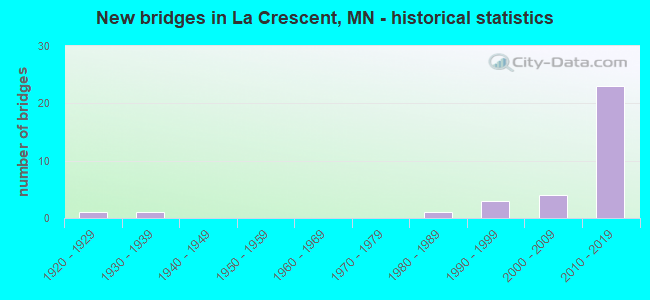
- New bridges - historical statistics
- 11920-1929
- 11930-1939
- 11980-1989
- 31990-1999
- 42000-2009
- 232010-2019


- Bridge Condition - Deck
- 14.3%Very good
- 64.3%Good
- 21.4%Satisfactory

- Bridge Condition - Superstructure
- 42.9%Very good
- 57.1%Good

- Bridge Condition - Substructure
- 35.7%Very good
- 42.9%Good
- 21.4%Satisfactory

- Bridge Condition - Channel
- 33.3%Very good
- 8.3%Good
- 58.3%Satisfactory

- Bridge Condition - Culverts
- 25.0%Very good
- 25.0%Good
- 25.0%Satisfactory
- 25.0%Fair
Find on map >> Show street view
Structure Number: 28002, Location: 1.0 MI S OF JCT TH 61 (Lat: 43.809369, Lng: -91.304689), Route carried "on" structure: State highway 16, Year Built: 1990, Status: Open, Structure Length: 5.92m (19.42ft), Average Daily Traffic: 10,910 (year 2019), Truck Traffic: 6%, Average Future Daily Traffic: 10,600 (year 2039), Design Load: HS 25 or greater, Features Intersected: PINE CREEK
Minimum Vertical Clearance: 30+ m (98+ ft), Kilometerpoint: 0.000, Lanes on structure: 2, Base Highway Network: Yes, Owner: State Highway Agency, Approaching Roadway Width: 13.4m (44.0ft), Skew: 4 degrees, Material/Design: Concrete continuous, Design/Construction: Slab, Number Of Spans In Main Unit: 6, Length of Maximum Span: 10.4m (34.1ft), Curb or Sidewalk Widths: Left: 1.8m (5.9ft), Right: 1.8m (5.9ft), Curb-To-Curb Width: 15.9m (52.2ft), Out-to-Out Width: 20.2m (66.3ft)
Condition: Deck: Good, Superstructure: Good, Substructure: Satisfactory, Channel: Satisfactory, Operating Rating: 99.6 metric tons, Method Used To Determine Operating Rating: Load Factor (LF), Inventory Rating: 61.7 metric tons, Method Used To Determine Inventory Rating: Load Factor (LF), Structural Evaluation: Equal to present minimum criteria, Deck Geometry: Superior to present desirable criteria, Waterway Adequacy: Superior to present desirable criteria, Approach Roadway Alignment: Equal to present desirable criteria, Designated Inspection Frequency: Every 24 months, Underwater Inspection Frequency: Every 60 months, Inspection Date: August 2020, Underwater Inspection Date: May 2021, Deck Structure Type: Concrete Cast-file-Place, Wearing Surface/Protective System: Wearing Surface: Monolithic Concrete, Deck Protection: Epoxy Coated Reinforcing
Find on map >> Show street view
Structure Number: 28004, Location: 1.1 MI S OF JCT TH 16 (Lat: 43.776853, Lng: -91.297814), Route carried "on" structure: State highway 26, Year Built: 1997, Status: Open, Structure Length: 9.39m (30.81ft), Average Daily Traffic: 2,802 (year 2019), Truck Traffic: 6%, Average Future Daily Traffic: 2,800 (year 2039), Design Load: HS 25 or greater, Features Intersected: ROOT RIVER
Minimum Vertical Clearance: 30+ m (98+ ft), Kilometerpoint: 0.000, Lanes on structure: 2, Base Highway Network: Yes, Owner: State Highway Agency, Approaching Roadway Width: 12.2m (40.0ft), Material/Design: Steel continuous, Design/Construction: Stringer/Multi-beam, Number Of Spans In Main Unit: 2, Length of Maximum Span: 46.2m (151.6ft), Curb-To-Curb Width: 14.6m (47.9ft), Out-to-Out Width: 15.6m (51.2ft)
Condition: Deck: Good, Superstructure: Very good, Substructure: Satisfactory, Channel: Satisfactory, Operating Rating: 72.5 metric tons, Method Used To Determine Operating Rating: Load Factor (LF), Inventory Rating: 43.4 metric tons, Method Used To Determine Inventory Rating: Load Factor (LF), Structural Evaluation: Equal to present minimum criteria, Deck Geometry: Superior to present desirable criteria, Waterway Adequacy: Superior to present desirable criteria, Approach Roadway Alignment: Equal to present desirable criteria, Designated Inspection Frequency: Every 24 months, Inspection Date: August 2020, Deck Structure Type: Concrete Cast-file-Place, Wearing Surface/Protective System: Wearing Surface: Low Slump Concrete, Deck Protection: Epoxy Coated Reinforcing
Find on map >> Show street view
Structure Number: 28019, Location: 0.1 MI S OF JCT TH 16 (Lat: 43.789917, Lng: -91.302728), Route carried "on" structure: State highway 26, Year Built: 1997, Status: Open, Structure Length: 13.79m (45.24ft), Average Daily Traffic: 2,802 (year 2019), Truck Traffic: 6%, Average Future Daily Traffic: 2,800 (year 2039), Design Load: HS 25 or greater, Features Intersected: OVERFLOW FROM ROOT RIVER
Minimum Vertical Clearance: 30+ m (98+ ft), Kilometerpoint: 0.000, Lanes on structure: 2, Base Highway Network: Yes, Owner: State Highway Agency, Approaching Roadway Width: 12.2m (40.0ft), Material/Design: Prestressed concrete, Design/Construction: Stringer/Multi-beam, Number Of Spans In Main Unit: 5, Length of Maximum Span: 27.4m (89.9ft), Curb-To-Curb Width: 14.6m (47.9ft), Out-to-Out Width: 15.6m (51.2ft)
Condition: Deck: Good, Superstructure: Very good, Substructure: Good, Channel: Very good, Operating Rating: 68.2 metric tons, Method Used To Determine Operating Rating: Load Factor (LF), Inventory Rating: 43.4 metric tons, Method Used To Determine Inventory Rating: Load Factor (LF), Structural Evaluation: Better than present minimum criteria, Deck Geometry: Superior to present desirable criteria, Waterway Adequacy: Superior to present desirable criteria, Approach Roadway Alignment: Equal to present desirable criteria, Designated Inspection Frequency: Every 24 months, Underwater Inspection Frequency: Every 60 months, Inspection Date: August 2020, Underwater Inspection Date: May 2021, Deck Structure Type: Concrete Cast-file-Place, Wearing Surface/Protective System: Wearing Surface: Low Slump Concrete, Deck Protection: Epoxy Coated Reinforcing
Find on map >> Show street view
Structure Number: 28022, Location: 0.1 MI E OF JCT MN 16 (Lat: 43.825614, Lng: -91.302381), Route carried "on" structure: US 61, Year Built: 2007, Status: Open, Structure Length: 6.00m (19.69ft), Average Daily Traffic: 17,716 (year 2019), Truck Traffic: 2%, Average Future Daily Traffic: 17,700 (year 2039), Design Load: HS 25 or greater, Features Intersected: IM RAIL AND STREET
Minimum Vertical Clearance: 30+ m (98+ ft), Kilometerpoint: 0.000, Lanes on structure: 7, Lanes under structure: 2, Base Highway Network: Yes, Owner: State Highway Agency, Approaching Roadway Width: 30.0m (98.4ft), Skew: 30 degrees, Material/Design: Prestressed concrete, Design/Construction: Stringer/Multi-beam, Number Of Spans In Main Unit: 2, Length of Maximum Span: 31.0m (101.7ft), Curb or Sidewalk Widths: Left: 2.0m (6.6ft), Right: 2.0m (6.6ft), Curb-To-Curb Width: 30.0m (98.4ft), Out-to-Out Width: 37.0m (121.4ft)
Condition: Deck: Good, Superstructure: Good, Substructure: Good, Operating Rating: 65.7 metric tons, Method Used To Determine Operating Rating: Load Factor (LF), Inventory Rating: 37.9 metric tons, Method Used To Determine Inventory Rating: Load Factor (LF), Structural Evaluation: Better than present minimum criteria, Deck Geometry: Equal to present minimum criteria, Underclear: Superior to present desirable criteria, Approach Roadway Alignment: Equal to present desirable criteria, Designated Inspection Frequency: Every 24 months, Inspection Date: August 2020, Deck Structure Type: Concrete Cast-file-Place, Wearing Surface/Protective System: Wearing Surface: Low Slump Concrete, Deck Protection: Epoxy Coated Reinforcing
Find on map >> Show street view
Structure Number: 28512, Location: 1.5 MI W OF JCT CSAH 25 (Lat: 43.829822, Lng: -91.341025), Route carried "on" structure: County highway 6, Year Built: 1980, Status: Open, Structure Length: 5.19m (17.03ft), Average Daily Traffic: 922 (year 2019), Truck Traffic: 4%, Average Future Daily Traffic: 920 (year 2039), Design Load: HS 20, Features Intersected: PINE CREEK
Minimum Vertical Clearance: 30+ m (98+ ft), Kilometerpoint: 0.000, Lanes on structure: 2, Owner: County Highway Agency, Approaching Roadway Width: 9.8m (32.2ft), Skew: 2 degrees, Material/Design: Steel continuous, Design/Construction: Stringer/Multi-beam, Number Of Spans In Main Unit: 3, Length of Maximum Span: 19.8m (65.0ft), Curb-To-Curb Width: 11.0m (36.1ft), Out-to-Out Width: 12.0m (39.4ft)
Condition: Deck: Satisfactory, Superstructure: Good, Substructure: Satisfactory, Channel: Good, Operating Rating: 55.7 metric tons, Method Used To Determine Operating Rating: Load Factor (LF), Inventory Rating: 33.3 metric tons, Method Used To Determine Inventory Rating: Load Factor (LF), Structural Evaluation: Equal to present minimum criteria, Deck Geometry: Better than present minimum criteria, Waterway Adequacy: Equal to present desirable criteria, Approach Roadway Alignment: Equal to present desirable criteria, Designated Inspection Frequency: Every 24 months, Inspection Date: May 2021, Deck Structure Type: Concrete Cast-file-Place, Wearing Surface/Protective System: Wearing Surface: Monolithic Concrete
Find on map >> Show street view
Structure Number: 28522, Location: 0.6 MI W OF JCT CSAH 6 (Lat: 43.818169, Lng: -91.326889), Route carried "on" structure: County highway 25, Year Built: 2000, Status: Open, Structure Length: 3.55m (11.65ft), Average Daily Traffic: 661 (year 2019), Truck Traffic: 9%, Average Future Daily Traffic: 660 (year 2039), Design Load: HS 25 or greater, Features Intersected: PINE CREEK
Minimum Vertical Clearance: 30+ m (98+ ft), Kilometerpoint: 0.000, Lanes on structure: 2, Owner: County Highway Agency, Approaching Roadway Width: 12.2m (40.0ft), Material/Design: Concrete continuous, Design/Construction: Slab, Number Of Spans In Main Unit: 3, Length of Maximum Span: 13.4m (44.0ft), Curb-To-Curb Width: 13.4m (44.0ft), Out-to-Out Width: 14.4m (47.2ft)
Condition: Deck: Good, Superstructure: Good, Substructure: Good, Channel: Satisfactory, Operating Rating: 79.0 metric tons, Method Used To Determine Operating Rating: Load Factor (LF), Inventory Rating: 47.3 metric tons, Method Used To Determine Inventory Rating: Load Factor (LF), Structural Evaluation: Better than present minimum criteria, Deck Geometry: Superior to present desirable criteria, Waterway Adequacy: Equal to present desirable criteria, Approach Roadway Alignment: Equal to present desirable criteria, Designated Inspection Frequency: Every 24 months, Inspection Date: May 2021, Wearing Surface/Protective System: Wearing Surface: Monolithic Concrete, Deck Protection: Epoxy Coated Reinforcing
Find on map >> Show street view
Structure Number: 28527, Location: 0.5 MI S OF JCT CSAH 25 (Lat: 43.811019, Lng: -91.318772), Route carried "on" structure: County highway 306, Year Built: 2000, Status: Open, Structure Length: 4.25m (13.94ft), Average Daily Traffic: 50 (year 1999), Average Future Daily Traffic: 50 (year 2029), Design Load: HS 25 or greater, Features Intersected: PINE CREEK
Minimum Vertical Clearance: 30+ m (98+ ft), Kilometerpoint: 0.000, Lanes on structure: 2, Owner: Town or Township Highway Agency, Approaching Roadway Width: 8.4m (27.6ft), Skew: 3 degrees, Material/Design: Concrete continuous, Design/Construction: Slab, Number Of Spans In Main Unit: 3, Length of Maximum Span: 16.7m (54.8ft), Curb-To-Curb Width: 8.4m (27.6ft), Out-to-Out Width: 9.4m (30.8ft)
Condition: Deck: Good, Superstructure: Good, Substructure: Good, Channel: Satisfactory, Operating Rating: 96.0 metric tons, Method Used To Determine Operating Rating: Load Factor (LF), Inventory Rating: 57.5 metric tons, Method Used To Determine Inventory Rating: Load Factor (LF), Structural Evaluation: Better than present minimum criteria, Deck Geometry: Equal to present minimum criteria, Waterway Adequacy: Equal to present desirable criteria, Approach Roadway Alignment: Equal to present desirable criteria, Designated Inspection Frequency: Every 24 months, Inspection Date: April 2021, Deck Structure Type: Concrete Cast-file-Place, Wearing Surface/Protective System: Wearing Surface: Monolithic Concrete, Deck Protection: Epoxy Coated Reinforcing
Find on map >> Show street view
Structure Number: 28J35, Location: 2.8 MI NW OF JCT CSAH 25 (Lat: 43.833017, Lng: -91.370231), Route carried "on" structure: County highway 6, Year Built: 2011, Status: Open, Structure Length: 0.77m (2.53ft), Average Daily Traffic: 922 (year 2019), Truck Traffic: 4%, Average Future Daily Traffic: 920 (year 2039), Design Load: HS 25 or greater, Features Intersected: STREAM
Minimum Vertical Clearance: 30+ m (98+ ft), Kilometerpoint: 0.000, Lanes on structure: 2, Owner: County Highway Agency, Approaching Roadway Width: 10.7m (35.1ft), Skew: 3 degrees, Material/Design: Concrete, Design/Construction: Culvert, Number Of Spans In Main Unit: 2, Length of Maximum Span: 3.5m (11.5ft)
Condition: Channel: Satisfactory, Culverts: Good, Operating Rating: 68.6 metric tons, Method Used To Determine Operating Rating: Assigned ratings based on Load and Resistance Factor Design (LRFD) reported in metric tons, Inventory Rating: 40.8 metric tons, Method Used To Determine Inventory Rating: Assigned ratings based on Load and Resistance Factor Design (LRFD) reported in metric tons, Structural Evaluation: Better than present minimum criteria, Waterway Adequacy: Equal to present desirable criteria, Approach Roadway Alignment: Equal to present desirable criteria, Designated Inspection Frequency: Every 48 months, Inspection Date: May 2021
Find on map >> Show street view
Structure Number: 689, Location: 1.1 MI S OF JCT TH 61 (Lat: 43.809364, Lng: -91.304694), Route carried "on" structure: State highway 16, Year Built: 1931, Status: Open, Structure Length: 0.85m (2.79ft), Average Daily Traffic: 10,910 (year 2019), Truck Traffic: 6%, Average Future Daily Traffic: 10,600 (year 2039), Design Load: H 15, Features Intersected: PINE CREEK
Minimum Vertical Clearance: 30+ m (98+ ft), Kilometerpoint: 0.000, Lanes on structure: 2, Base Highway Network: Yes, Owner: State Highway Agency, Approaching Roadway Width: 12.2m (40.0ft), Skew: 1 degrees, Material/Design: Concrete, Design/Construction: Culvert, Number Of Spans In Main Unit: 2, Length of Maximum Span: 4.0m (13.1ft)
Condition: Channel: Satisfactory, Culverts: Fair, Operating Rating: 39.2 metric tons, Method Used To Determine Operating Rating: Assigned ratings based on Allowable Stress Design (ASD) reported in metric tons, Inventory Rating: 29.4 metric tons, Method Used To Determine Inventory Rating: Assigned ratings based on Allowable Stress Design (ASD) reported in metric tons, Structural Evaluation: Somewhat better than minimum adequacy, Waterway Adequacy: Equal to present desirable criteria, Approach Roadway Alignment: Equal to present desirable criteria, Length Of Structure Improvement: 0.43m (1.41ft), Designated Inspection Frequency: Every 24 months, Inspection Date: August 2020, Bridge Improvement Cost: $108,000,000, Roadway Improvement Cost: $3,000,000, Total Project Cost: $51,000,000
Find on map >> Show street view
Structure Number: 8263, Location: 0.6 MI N OF LA CRESCENT (Lat: 43.845719, Lng: -91.298269), Route carried "on" structure: US 61, Year Built: 1926, Status: Open, Structure Length: 0.63m (2.07ft), Average Daily Traffic: 13,812 (year 2019), Truck Traffic: 6%, Average Future Daily Traffic: 13,500 (year 2039), Design Load: H 15, Features Intersected: DITCH
Minimum Vertical Clearance: 30+ m (98+ ft), Kilometerpoint: 0.000, Lanes on structure: 4, Base Highway Network: Yes, Owner: State Highway Agency, Approaching Roadway Width: 23.2m (76.1ft), Skew: 24 degrees, Material/Design: Concrete, Design/Construction: Culvert, Number Of Spans In Main Unit: 2, Length of Maximum Span: 2.7m (8.9ft)
Condition: Channel: Satisfactory, Culverts: Satisfactory, Operating Rating: 39.2 metric tons, Method Used To Determine Operating Rating: Assigned ratings based on Allowable Stress Design (ASD) reported in metric tons, Inventory Rating: 26.1 metric tons, Method Used To Determine Inventory Rating: Assigned ratings based on Allowable Stress Design (ASD) reported in metric tons, Structural Evaluation: Equal to present minimum criteria, Waterway Adequacy: Equal to present minimum criteria, Approach Roadway Alignment: Equal to present desirable criteria, Designated Inspection Frequency: Every 24 months, Inspection Date: August 2020
Find on map >> Show street view
Structure Number: 85014, Location: 5.6 MI SE JCT TH 61 & 90 (Lat: 43.856625, Lng: -91.304169), Route carried "on" structure: Ramp Interstate 2813, Year Built: 2016, Status: Open, Structure Length: 16.01m (52.53ft), Average Daily Traffic: 7,130 (year 2014), Average Future Daily Traffic: 7,130 (year 2035), Design Load: HL 93, Features Intersected: RR; BIKE PATH
Minimum Vertical Clearance: 30+ m (98+ ft), Kilometerpoint: 0.000, Lanes on structure: 1, Base Highway Network: Yes, Owner: State Highway Agency, Approaching Roadway Width: 9.1m (29.9ft), Material/Design: Steel continuous, Design/Construction: Stringer/Multi-beam, Number Of Spans In Main Unit: 3, Length of Maximum Span: 61.0m (200.1ft), Curb-To-Curb Width: 9.1m (29.9ft), Out-to-Out Width: 10.2m (33.5ft)
Condition: Deck: Good, Superstructure: Very good, Substructure: Very good, Operating Rating: 55.4 metric tons, Method Used To Determine Operating Rating: Load and Resistance Factor Rating (LRFR) rating reported by rating factor(RF) method using HL-93 loadings, Inventory Rating: 42.8 metric tons, Method Used To Determine Inventory Rating: Load and Resistance Factor Rating (LRFR) rating reported by rating factor(RF) method using HL-93 loadings, Structural Evaluation: Equal to present desirable criteria, Deck Geometry: Superior to present desirable criteria, Underclear: Superior to present desirable criteria, Approach Roadway Alignment: Somewhat better than minimum adequacy, Designated Inspection Frequency: Every 24 months, Inspection Date: October 2020, Deck Structure Type: Concrete Cast-file-Place, Wearing Surface/Protective System: Wearing Surface: Epoxy Overlay, Deck Protection: Epoxy Coated Reinforcing
Find on map >> Show street view
Structure Number: 85027, Location: 5.4 MI SE OF JCT 61; 90 (Lat: 43.859811, Lng: -91.307853), Route carried "on" structure: ServiceCounty highway 804, Year Built: 2013, Status: Open, Structure Length: 3.53m (11.58ft), Average Daily Traffic: 1 (year 2013), Average Future Daily Traffic: 500 (year 2035), Design Load: HL 93, Features Intersected: CP RR
Minimum Vertical Clearance: 30+ m (98+ ft), Kilometerpoint: 0.000, Lanes on structure: 2, Owner: State Highway Agency, Approaching Roadway Width: 10.4m (34.1ft), Skew: 21 degrees, Material/Design: Prestressed concrete, Design/Construction: Stringer/Multi-beam, Number Of Spans In Main Unit: 1, Length of Maximum Span: 34.2m (112.2ft), Curb or Sidewalk Widths: Left: 3.7m (12.1ft), Right: 0.0m, Curb-To-Curb Width: 15.2m (49.9ft), Out-to-Out Width: 19.8m (65.0ft)
Condition: Deck: Very good, Superstructure: Very good, Substructure: Very good, Operating Rating: 52.8 metric tons, Method Used To Determine Operating Rating: Load and Resistance Factor Rating (LRFR) rating reported by rating factor(RF) method using HL-93 loadings, Inventory Rating: 36.6 metric tons, Method Used To Determine Inventory Rating: Load and Resistance Factor Rating (LRFR) rating reported by rating factor(RF) method using HL-93 loadings, Structural Evaluation: Equal to present desirable criteria, Deck Geometry: Superior to present desirable criteria, Underclear: High priority of corrective action, Approach Roadway Alignment: Equal to present desirable criteria, Designated Inspection Frequency: Every 24 months, Inspection Date: October 2020, Deck Structure Type: Concrete Cast-file-Place, Wearing Surface/Protective System: Wearing Surface: Monolithic Concrete, Deck Protection: Epoxy Coated Reinforcing
Find on map >> Show street view
Structure Number: 85801, Location: AT MINN/WISC STATE LINE (Lat: 43.858181, Lng: -91.300111), Route carried "on" structure: Interstate 90, Year Built: 2016, Status: Open, Structure Length: 79.02m (259.25ft), Average Daily Traffic: 13,000 (year 2017), Truck Traffic: 13%, Average Future Daily Traffic: 13,000 (year 2039), Design Load: HL 93, Features Intersected: AOI; MISSISSIPPI RIVER
Minimum Vertical Clearance: 30+ m (98+ ft), Kilometerpoint: 0.000, Lanes on structure: 2, Lanes under structure: 2, Base Highway Network: Yes, Owner: State Highway Agency, Approaching Roadway Width: 15.2m (49.9ft), Navigation Control: Yes ( Vertical Clearance: 20.8m (68.2ft), Horizontal Clearance: 134.7m (441.9ft)), Material/Design: Prestressed concrete, Design/Construction: Segmental Box Girder, Number Of Spans In Main Unit: 4, Number Of Approach Spans: 6, Length of Maximum Span: 154.8m (507.9ft), Curb-To-Curb Width: 12.8m (42.0ft), Out-to-Out Width: 13.8m (45.3ft)
Condition: Deck: Satisfactory, Superstructure: Good, Substructure: Very good, Channel: Very good, Operating Rating: 33.0 metric tons, Method Used To Determine Operating Rating: Load and Resistance Factor Rating (LRFR) rating reported by rating factor(RF) method using HL-93 loadings, Inventory Rating: 32.4 metric tons, Method Used To Determine Inventory Rating: Load and Resistance Factor Rating (LRFR) rating reported by rating factor(RF) method using HL-93 loadings, Structural Evaluation: Better than present minimum criteria, Deck Geometry: Equal to present desirable criteria, Underclear: Superior to present desirable criteria, Waterway Adequacy: Superior to present desirable criteria, Approach Roadway Alignment: Equal to present desirable criteria, Designated Inspection Frequency: Every 24 months, Underwater Inspection Frequency: Every 60 months, Inspection Date: October 2020, Underwater Inspection Date: November 2021, Deck Structure Type: Concrete Cast-file-Place, Wearing Surface/Protective System: Wearing Surface: Monolithic Concrete, Deck Protection: Other
Find on map >> Show street view
Structure Number: 85802, Location: AT MINN/WISC STATE LINE (Lat: 43.858014, Lng: -91.300278), Route carried "on" structure: Interstate 90, Year Built: 2015, Status: Open, Structure Length: 79.02m (259.25ft), Average Daily Traffic: 11,000 (year 2019), Truck Traffic: 14%, Average Future Daily Traffic: 13,000 (year 2039), Design Load: HL 93, Features Intersected: AOI; MISSISSIPPI RIVER
Minimum Vertical Clearance: 30+ m (98+ ft), Kilometerpoint: 0.000, Lanes on structure: 2, Lanes under structure: 2, Base Highway Network: Yes, Owner: State Highway Agency, Approaching Roadway Width: 15.2m (49.9ft), Navigation Control: Yes ( Vertical Clearance: 20.8m (68.2ft), Horizontal Clearance: 134.7m (441.9ft)), Material/Design: Prestressed concrete, Design/Construction: Segmental Box Girder, Number Of Spans In Main Unit: 4, Number Of Approach Spans: 6, Length of Maximum Span: 154.8m (507.9ft), Curb-To-Curb Width: 12.8m (42.0ft), Out-to-Out Width: 13.8m (45.3ft)
Condition: Deck: Good, Superstructure: Good, Substructure: Very good, Channel: Very good, Operating Rating: 33.0 metric tons, Method Used To Determine Operating Rating: Load and Resistance Factor Rating (LRFR) rating reported by rating factor(RF) method using HL-93 loadings, Inventory Rating: 32.4 metric tons, Method Used To Determine Inventory Rating: Load and Resistance Factor Rating (LRFR) rating reported by rating factor(RF) method using HL-93 loadings, Structural Evaluation: Better than present minimum criteria, Deck Geometry: Equal to present desirable criteria, Underclear: Superior to present desirable criteria, Waterway Adequacy: Superior to present desirable criteria, Approach Roadway Alignment: Equal to present desirable criteria, Designated Inspection Frequency: Every 24 months, Underwater Inspection Frequency: Every 60 months, Inspection Date: October 2020, Underwater Inspection Date: November 2021, Deck Structure Type: Concrete Cast-file-Place, Wearing Surface/Protective System: Wearing Surface: Monolithic Concrete, Deck Protection: Other
Find on map >> Show street view
Structure Number: 85805, Location: WEST I 90 (Lat: 43.858875, Lng: -91.306586), Route carried "on" structure: Ramp Interstate 5609, Year Built: 2016, Status: Open, Structure Length: 19.49m (63.94ft), Average Daily Traffic: 7,650 (year 2014), Average Future Daily Traffic: 7,650 (year 2035), Design Load: HL 93, Features Intersected: I 90; TH 61; RR
Minimum Vertical Clearance: 30+ m (98+ ft), Kilometerpoint: 0.000, Lanes on structure: 1, Lanes under structure: 10, Base Highway Network: Yes, Owner: State Highway Agency, Approaching Roadway Width: 10.4m (34.1ft), Skew: 2 degrees, Material/Design: Steel continuous, Design/Construction: Stringer/Multi-beam, Number Of Spans In Main Unit: 4, Length of Maximum Span: 56.1m (184.1ft), Curb-To-Curb Width: 10.4m (34.1ft), Out-to-Out Width: 11.4m (37.4ft)
Condition: Deck: Very good, Superstructure: Very good, Substructure: Good, Operating Rating: 43.4 metric tons, Method Used To Determine Operating Rating: Load and Resistance Factor Rating (LRFR) rating reported by rating factor(RF) method using HL-93 loadings, Inventory Rating: 33.4 metric tons, Method Used To Determine Inventory Rating: Load and Resistance Factor Rating (LRFR) rating reported by rating factor(RF) method using HL-93 loadings, Structural Evaluation: Better than present minimum criteria, Deck Geometry: Superior to present desirable criteria, Underclear: High priority of corrective action, Approach Roadway Alignment: Equal to present minimum criteria, Designated Inspection Frequency: Every 24 months, Inspection Date: October 2020, Deck Structure Type: Concrete Cast-file-Place, Wearing Surface/Protective System: Wearing Surface: Monolithic Concrete, Deck Protection: Epoxy Coated Reinforcing
Find on map >> Show street view
Structure Number: 85849, Location: AT JCT TH 61 (Lat: 43.858417, Lng: -91.305861), Route carried "on" structure: Interstate 90, Year Built: 2015, Status: Open, Structure Length: 35.55m (116.63ft), Average Daily Traffic: 13,000 (year 2016), Truck Traffic: 14%, Average Future Daily Traffic: 13,000 (year 2039), Design Load: HL 93, Features Intersected: RAMPS; AOI ACCESS; CP RR
Minimum Vertical Clearance: 30+ m (98+ ft), Kilometerpoint: 0.000, Lanes on structure: 2, Lanes under structure: 5, Base Highway Network: Yes, Owner: State Highway Agency, Approaching Roadway Width: 12.2m (40.0ft), Material/Design: Steel continuous, Design/Construction: Stringer/Multi-beam, Number Of Spans In Main Unit: 5, Length of Maximum Span: 83.8m (274.9ft), Curb-To-Curb Width: 12.8m (42.0ft), Out-to-Out Width: 13.8m (45.3ft)
Condition: Deck: Satisfactory, Superstructure: Very good, Substructure: Very good, Operating Rating: 54.4 metric tons, Method Used To Determine Operating Rating: Load and Resistance Factor Rating (LRFR) rating reported by rating factor(RF) method using HL-93 loadings, Inventory Rating: 41.8 metric tons, Method Used To Determine Inventory Rating: Load and Resistance Factor Rating (LRFR) rating reported by rating factor(RF) method using HL-93 loadings, Structural Evaluation: Equal to present desirable criteria, Deck Geometry: Equal to present desirable criteria, Underclear: Somewhat better than minimum adequacy, Approach Roadway Alignment: Better than present minimum criteria, Designated Inspection Frequency: Every 24 months, Inspection Date: October 2020, Deck Structure Type: Concrete Cast-file-Place, Wearing Surface/Protective System: Wearing Surface: Monolithic Concrete, Deck Protection: Epoxy Coated Reinforcing
Find on map >> Show street view
Structure Number: 8585, Location: AT JCT TH 61 (Lat: 43.858258, Lng: -91.305908), Route carried "on" structure: Interstate 90, Year Built: 2016, Status: Open, Structure Length: 38.77m (127.20ft), Average Daily Traffic: 11,000 (year 2019), Truck Traffic: 14%, Average Future Daily Traffic: 13,000 (year 2039), Design Load: HL 93, Features Intersected: TH 61; RAMPS; CP RR
Minimum Vertical Clearance: 30+ m (98+ ft), Kilometerpoint: 0.000, Lanes on structure: 2, Lanes under structure: 5, Base Highway Network: Yes, Owner: State Highway Agency, Approaching Roadway Width: 14.0m (45.9ft), Material/Design: Steel continuous, Design/Construction: Stringer/Multi-beam, Number Of Spans In Main Unit: 6, Length of Maximum Span: 75.0m (246.1ft), Curb-To-Curb Width: 14.0m (45.9ft), Out-to-Out Width: 15.0m (49.2ft)
Condition: Deck: Good, Superstructure: Good, Substructure: Good, Operating Rating: 54.4 metric tons, Method Used To Determine Operating Rating: Load and Resistance Factor Rating (LRFR) rating reported by rating factor(RF) method using HL-93 loadings, Inventory Rating: 41.8 metric tons, Method Used To Determine Inventory Rating: Load and Resistance Factor Rating (LRFR) rating reported by rating factor(RF) method using HL-93 loadings, Structural Evaluation: Better than present minimum criteria, Deck Geometry: Superior to present desirable criteria, Underclear: Meets minimum limits, Approach Roadway Alignment: Better than present minimum criteria, Designated Inspection Frequency: Every 24 months, Inspection Date: October 2020, Deck Structure Type: Concrete Cast-file-Place, Wearing Surface/Protective System: Wearing Surface: Epoxy Overlay, Deck Protection: Epoxy Coated Reinforcing
Find on map >> Show street view
Structure Number: 85J3, Location: 1.1 MI E OF JCT CSAH 16 (Lat: 43.847064, Lng: -91.380067), Route carried "on" structure: County highway 311, Year Built: 2013, Status: Open, Structure Length: 1.21m (3.97ft), Average Daily Traffic: 50 (year 2013), Average Future Daily Traffic: 50 (year 2033), Design Load: HL 93, Features Intersected: STREAM
Minimum Vertical Clearance: 30+ m (98+ ft), Kilometerpoint: 0.000, Lanes on structure: 2, Owner: Town or Township Highway Agency, Approaching Roadway Width: 8.5m (27.9ft), Material/Design: Concrete, Design/Construction: Culvert, Number Of Spans In Main Unit: 3, Length of Maximum Span: 3.7m (12.1ft)
Condition: Channel: Very good, Culverts: Very good, Operating Rating: 42.1 metric tons, Method Used To Determine Operating Rating: Assigned ratings based on Load and Resistance Factor Design (LRFD) reported by rating factor (RF) using HL93 loadings, Inventory Rating: 32.4 metric tons, Method Used To Determine Inventory Rating: Assigned ratings based on Load and Resistance Factor Design (LRFD) reported by rating factor (RF) using HL93 loadings, Structural Evaluation: Equal to present desirable criteria, Waterway Adequacy: Superior to present desirable criteria, Approach Roadway Alignment: Equal to present desirable criteria, Designated Inspection Frequency: Every 48 months, Inspection Date: October 2020
Find on map >> Show street view
Structure Number: 28022, Location: 0.1 MI E OF JCT MN 16 (Lat: 43.825614, Lng: -91.302381), Route carried "under" structure: City street 56, Year Built: 2007, Structure Length: 0. m, Average Daily Traffic: 200 (year 2012), Features Intersected: IM RAIL AND STREET, Facility Carried by Structure: US 61
Minimum Vertical Clearance: 6.98m (22.90ft), Kilometerpoint: 0.000, Lanes on structure: 7, Lanes under structure: 2, Material/Design: Prestressed concrete, Design/Construction: Stringer/Multi-beam, Length of Maximum Span: 31.0m (101.7ft)
Find on map >> Show street view
Structure Number: 85801, Location: AT MINN/WISC STATE LINE (Lat: 43.858181, Lng: -91.300111), Route carried "under" structure: County highway 804, Year Built: 2016, Structure Length: 0. m, Average Daily Traffic: 1 (year 2011), Features Intersected: AOI; MISSISSIPPI RIVER, Facility Carried by Structure: I 90
Minimum Vertical Clearance: 16.19m (53.12ft), Lanes under structure: 2, Material/Design: Prestressed concrete, Design/Construction: Segmental Box Girder, Length of Maximum Span: 154.8m (507.9ft)
Find on map >> Show street view
Structure Number: 85802, Location: AT MINN/WISC STATE LINE (Lat: 43.858014, Lng: -91.300278), Route carried "under" structure: County highway 804, Year Built: 2015, Structure Length: 0. m, Average Daily Traffic: 1 (year 2011), Features Intersected: AOI; MISSISSIPPI RIVER, Facility Carried by Structure: I 90
Minimum Vertical Clearance: 16.28m (53.41ft), Lanes under structure: 2, Material/Design: Prestressed concrete, Design/Construction: Segmental Box Girder, Length of Maximum Span: 154.8m (507.9ft)
Find on map >> Show street view
Structure Number: 85805, Location: WEST I 90 (Lat: 43.858875, Lng: -91.306586), Route carried "under" structure: Interstate 90, Year Built: 2016, Structure Length: 0. m, Average Daily Traffic: 22,000 (year 2019), Truck Traffic: 14%, Features Intersected: I 90; TH 61; RR, Facility Carried by Structure: CON 5609
Minimum Vertical Clearance: 5.15m (16.90ft), Kilometerpoint: 0.000, Lanes under structure: 6, Material/Design: Steel continuous, Design/Construction: Stringer/Multi-beam, Length of Maximum Span: 56.1m (184.1ft)
Find on map >> Show street view
Structure Number: 85805, Location: WEST I 90 (Lat: 43.858875, Lng: -91.306586), Route carried "under" structure: US 61, Year Built: 2016, Structure Length: 0. m, Average Daily Traffic: 13,812 (year 2019), Truck Traffic: 6%, Features Intersected: I 90; TH 61; RR, Facility Carried by Structure: CON 5609
Minimum Vertical Clearance: 5.00m (16.40ft), Kilometerpoint: 0.000, Lanes under structure: 2, Material/Design: Steel continuous, Design/Construction: Stringer/Multi-beam, Length of Maximum Span: 56.1m (184.1ft)
Find on map >> Show street view
Structure Number: 85805, Location: WEST I 90 (Lat: 43.858875, Lng: -91.306586), Route carried "under" structure: Ramp Interstate 5611, Year Built: 2016, Structure Length: 0. m, Average Daily Traffic: 1 (year 2017), Features Intersected: I 90; TH 61; RR, Facility Carried by Structure: CON 5609
Minimum Vertical Clearance: 7.07m (23.20ft), Kilometerpoint: 0.000, Lanes under structure: 1, Material/Design: Steel continuous, Design/Construction: Stringer/Multi-beam, Length of Maximum Span: 56.1m (184.1ft)
Find on map >> Show street view
Structure Number: 85805, Location: WEST I 90 (Lat: 43.858875, Lng: -91.306586), Route carried "under" structure: Ramp Interstate 5613, Year Built: 2016, Structure Length: 0. m, Average Daily Traffic: 1 (year 2017), Features Intersected: I 90; TH 61; RR, Facility Carried by Structure: CON 5609
Minimum Vertical Clearance: 5.18m (16.99ft), Kilometerpoint: 0.000, Lanes under structure: 1, Material/Design: Steel continuous, Design/Construction: Stringer/Multi-beam, Length of Maximum Span: 56.1m (184.1ft)
Find on map >> Show street view
Structure Number: 85849, Location: AT JCT TH 61 (Lat: 43.858417, Lng: -91.305861), Route carried "under" structure: Ramp Interstate 5611, Year Built: 2015, Structure Length: 0. m, Average Daily Traffic: 1 (year 2016), Features Intersected: RAMPS; AOI ACCESS; CP RR, Facility Carried by Structure: I 90
Minimum Vertical Clearance: 8.23m (27.00ft), Kilometerpoint: 0.000, Lanes under structure: 1, Material/Design: Steel continuous, Design/Construction: Stringer/Multi-beam, Length of Maximum Span: 83.8m (274.9ft)
Find on map >> Show street view
Structure Number: 85849, Location: AT JCT TH 61 (Lat: 43.858417, Lng: -91.305861), Route carried "under" structure: US 61, Year Built: 2015, Structure Length: 0. m, Average Daily Traffic: 6,906 (year 2019), Truck Traffic: 6%, Features Intersected: RAMPS; AOI ACCESS; CP RR, Facility Carried by Structure: I 90
Minimum Vertical Clearance: 8.23m (27.00ft), Kilometerpoint: 0.000, Lanes under structure: 1, Material/Design: Steel continuous, Design/Construction: Stringer/Multi-beam, Length of Maximum Span: 83.8m (274.9ft)
Find on map >> Show street view
Structure Number: 85849, Location: AT JCT TH 61 (Lat: 43.858417, Lng: -91.305861), Route carried "under" structure: County highway 804, Year Built: 2015, Structure Length: 0. m, Average Daily Traffic: 1 (year 2016), Features Intersected: RAMPS; AOI ACCESS; CP RR, Facility Carried by Structure: I 90
Minimum Vertical Clearance: 5.82m (19.09ft), Kilometerpoint: 0.000, Lanes under structure: 2, Material/Design: Steel continuous, Design/Construction: Stringer/Multi-beam, Length of Maximum Span: 83.8m (274.9ft)
Find on map >> Show street view
Structure Number: 85849, Location: AT JCT TH 61 (Lat: 43.858417, Lng: -91.305861), Route carried "under" structure: Ramp Interstate 5609, Year Built: 2015, Structure Length: 0. m, Average Daily Traffic: 1 (year 2016), Features Intersected: RAMPS; AOI ACCESS; CP RR, Facility Carried by Structure: I 90
Minimum Vertical Clearance: 5.52m (18.11ft), Kilometerpoint: 0.000, Lanes under structure: 1, Material/Design: Steel continuous, Design/Construction: Stringer/Multi-beam, Length of Maximum Span: 83.8m (274.9ft)
Find on map >> Show street view
Structure Number: 8585, Location: AT JCT TH 61 (Lat: 43.858258, Lng: -91.305908), Route carried "under" structure: Ramp Interstate 5611, Year Built: 2016, Structure Length: 0. m, Average Daily Traffic: 1 (year 2016), Features Intersected: TH 61; RAMPS; CP RR, Facility Carried by Structure: I 90
Minimum Vertical Clearance: 5.09m (16.70ft), Kilometerpoint: 0.000, Lanes under structure: 1, Material/Design: Steel continuous, Design/Construction: Stringer/Multi-beam, Length of Maximum Span: 75.0m (246.1ft)
Find on map >> Show street view
Structure Number: 8585, Location: AT JCT TH 61 (Lat: 43.858258, Lng: -91.305908), Route carried "under" structure: US 61, Year Built: 2016, Structure Length: 0. m, Average Daily Traffic: 6,906 (year 2019), Truck Traffic: 6%, Features Intersected: TH 61; RAMPS; CP RR, Facility Carried by Structure: I 90
Minimum Vertical Clearance: 5.61m (18.41ft), Kilometerpoint: 0.000, Lanes under structure: 1, Material/Design: Steel continuous, Design/Construction: Stringer/Multi-beam, Length of Maximum Span: 75.0m (246.1ft)
Find on map >> Show street view
Structure Number: 8585, Location: AT JCT TH 61 (Lat: 43.858258, Lng: -91.305908), Route carried "under" structure: Ramp Interstate 5611, Year Built: 2016, Structure Length: 0. m, Average Daily Traffic: 1 (year 2016), Features Intersected: TH 61; RAMPS; CP RR, Facility Carried by Structure: I 90
Minimum Vertical Clearance: 8.23m (27.00ft), Kilometerpoint: 0.000, Lanes under structure: 1, Material/Design: Steel continuous, Design/Construction: Stringer/Multi-beam, Length of Maximum Span: 75.0m (246.1ft)
Find on map >> Show street view
Structure Number: 8585, Location: AT JCT TH 61 (Lat: 43.858258, Lng: -91.305908), Route carried "under" structure: County highway 804, Year Built: 2016, Structure Length: 0. m, Average Daily Traffic: 1 (year 2016), Features Intersected: TH 61; RAMPS; CP RR, Facility Carried by Structure: I 90
Minimum Vertical Clearance: 6.40m (21.00ft), Kilometerpoint: 0.000, Lanes under structure: 2, Material/Design: Steel continuous, Design/Construction: Stringer/Multi-beam, Length of Maximum Span: 75.0m (246.1ft)