Bridge Statistics for La Grange, New York (NY)
Condition, Traffic, Stress, Structural Evaluation, Project Costs
- National Bridge Inventory (NBI) Statistics
- 28Number of bridges
- 131ft / 39.9mTotal length
- $35,063,000Total costs
- 195,912Total average daily traffic
- 4,510Total average daily truck traffic
- National Bridge Inventory (NBI) Registered Bridges for La Grange
- No street view available for this location
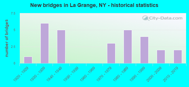
- New bridges - historical statistics
- 11920-1929
- 61930-1939
- 51940-1949
- 31970-1979
- 51980-1989
- 41990-1999
- 22000-2009
- 22010-2019
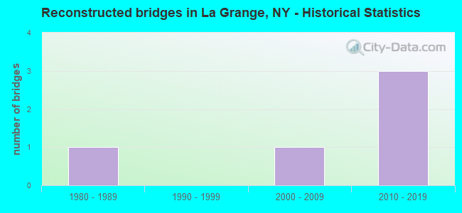
- Reconstructed bridges - Historical Statistics
- 11980-1989
- 01990-1999
- 12000-2009
- 32010-2019
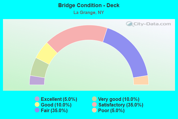
- Bridge Condition - Deck
- 5.0%Excellent
- 10.0%Very good
- 10.0%Good
- 35.0%Satisfactory
- 35.0%Fair
- 5.0%Poor
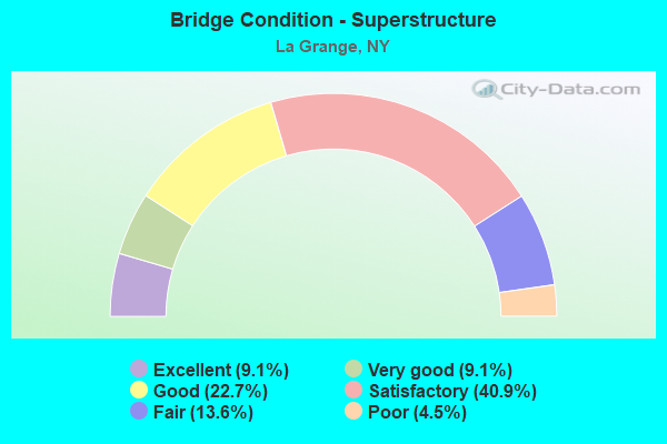
- Bridge Condition - Superstructure
- 9.1%Excellent
- 9.1%Very good
- 22.7%Good
- 40.9%Satisfactory
- 13.6%Fair
- 4.5%Poor
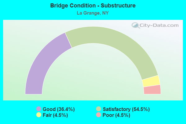
- Bridge Condition - Substructure
- 36.4%Good
- 54.5%Satisfactory
- 4.5%Fair
- 4.5%Poor
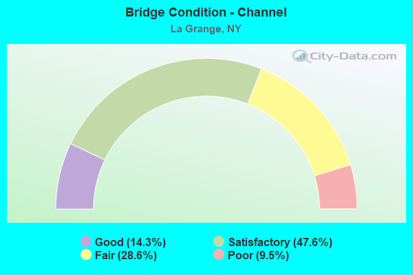
- Bridge Condition - Channel
- 14.3%Good
- 47.6%Satisfactory
- 28.6%Fair
- 9.5%Poor
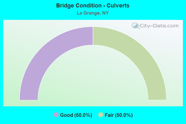
- Bridge Condition - Culverts
- 50.0%Good
- 50.0%Fair
Find on map >> Show street view
Structure Number: 102715, Location: 0.3 MI E JCT RTE 55+TSP (Lat: 41.670581, Lng: -73.783797), Route carried "on" structure: State highway 55, Year Built: 1931, Year Reconstructed: 1991, Status: Open, Structure Length: 1.62m (5.31ft), Average Daily Traffic: 11,698 (year 2018), Truck Traffic: 6%, Average Future Daily Traffic: 11,752 (year 2040), Design Load: HS 20+Mod, Features Intersected: SPROUT CREEK
Minimum Vertical Clearance: 30+ m (98+ ft), Kilometerpoint: 14.690, Lanes on structure: 2, Base Highway Network: Yes, Owner: State Highway Agency, Approaching Roadway Width: 8.2m (26.9ft), Skew: 23 degrees, Material/Design: Prestressed concrete, Design/Construction: Box Beam or Girders - Multiple, Number Of Spans In Main Unit: 1, Length of Maximum Span: 14.6m (47.9ft), Curb-To-Curb Width: 9.6m (31.5ft), Out-to-Out Width: 11.0m (36.1ft)
Condition: Deck: Satisfactory, Superstructure: Satisfactory, Substructure: Good, Channel: Good, Operating Rating: 69.3 metric tons, Method Used To Determine Operating Rating: Load and Resistance Factor Rating (LRFR) rating reported by rating factor(RF) method using HL-93 loadings, Inventory Rating: 47.6 metric tons, Method Used To Determine Inventory Rating: Load and Resistance Factor Rating (LRFR) rating reported by rating factor(RF) method using HL-93 loadings, Structural Evaluation: Equal to present minimum criteria, Deck Geometry: High priority of corrective action, Waterway Adequacy: Meets minimum limits, Approach Roadway Alignment: Equal to present desirable criteria, Length Of Structure Improvement: 1.61m (5.28ft), Designated Inspection Frequency: Every 24 months, Inspection Date: March 2021, Bridge Improvement Cost: $817,000, Roadway Improvement Cost: $479,000, Total Project Cost: $1,296,000 ( Estimate for 2021), Wearing Surface/Protective System: Wearing Surface: Integral Concrete
Find on map >> Show street view
Structure Number: 103232, Location: 1.9 MI N JCT RTE 82+TSP (Lat: 41.650058, Lng: -73.758164), Route carried "on" structure: State highway 82, Year Built: 1929, Status: Open, Structure Length: 0.82m (2.69ft), Average Daily Traffic: 6,388 (year 2019), Truck Traffic: 6%, Average Future Daily Traffic: 7,903 (year 2040), Design Load: H 20, Features Intersected: JACKSON CREEK
Minimum Vertical Clearance: 30+ m (98+ ft), Kilometerpoint: 15.800, Lanes on structure: 2, Base Highway Network: Yes, Owner: State Highway Agency, Approaching Roadway Width: 9.1m (29.9ft), Material/Design: Concrete, Design/Construction: Slab, Number Of Spans In Main Unit: 1, Length of Maximum Span: 7.3m (24.0ft), Curb-To-Curb Width: 7.9m (25.9ft), Out-to-Out Width: 8.8m (28.9ft)
Condition: Deck: Fair, Superstructure: Fair, Substructure: Satisfactory, Channel: Fair, Operating Rating: 65.3 metric tons, Method Used To Determine Operating Rating: Load Factor (LF), Inventory Rating: 39.0 metric tons, Method Used To Determine Inventory Rating: Load Factor (LF), Structural Evaluation: Somewhat better than minimum adequacy, Deck Geometry: High priority of replacement, Waterway Adequacy: Meets minimum limits, Approach Roadway Alignment: Meets minimum limits, Length Of Structure Improvement: 0.82m (2.69ft), Designated Inspection Frequency: Every 24 months, Inspection Date: June 2021, Bridge Improvement Cost: $354,000, Roadway Improvement Cost: $207,000, Total Project Cost: $561,000 ( Estimate for 2021), Wearing Surface/Protective System: Wearing Surface: Bituminous
Find on map >> Show street view
Structure Number: 104701, Location: 8.0 MI N JCT RTS 376 & 82 (Lat: 41.653906, Lng: -73.872967), Route carried "on" structure: State highway 376, Year Built: 1992, Status: Open, Structure Length: 3.08m (10.10ft), Average Daily Traffic: 22,492 (year 2008), Truck Traffic: 4%, Average Future Daily Traffic: 27,323 (year 2040), Design Load: HS 20, Features Intersected: WAPPINGER CREEK
Minimum Vertical Clearance: 30+ m (98+ ft), Kilometerpoint: 16.347, Lanes on structure: 4, Base Highway Network: Yes, Owner: State Highway Agency, Approaching Roadway Width: 17.4m (57.1ft), Skew: 1 degrees, Material/Design: Steel, Design/Construction: Stringer/Multi-beam, Number Of Spans In Main Unit: 1, Length of Maximum Span: 29.5m (96.8ft), Curb-To-Curb Width: 17.4m (57.1ft), Out-to-Out Width: 18.1m (59.4ft)
Condition: Deck: Satisfactory, Superstructure: Very good, Substructure: Good, Channel: Satisfactory, Operating Rating: 96.2 metric tons, Method Used To Determine Operating Rating: Load Factor (LF), Inventory Rating: 57.2 metric tons, Method Used To Determine Inventory Rating: Load Factor (LF), Structural Evaluation: Better than present minimum criteria, Deck Geometry: Somewhat better than minimum adequacy, Waterway Adequacy: Somewhat better than minimum adequacy, Approach Roadway Alignment: Equal to present desirable criteria, Length Of Structure Improvement: 3.07m (10.07ft), Designated Inspection Frequency: Every 24 months, Inspection Date: May 2020, Bridge Improvement Cost: $3,072,000, Roadway Improvement Cost: $1,799,000, Total Project Cost: $4,871,000 ( Estimate for 2021), Deck Structure Type: Concrete Cast-file-Place, Wearing Surface/Protective System: Wearing Surface: Integral Concrete, Deck Protection: Epoxy Coated Reinforcing
Find on map >> Show street view
Structure Number: 226287, Location: 3.0 MI NE OF FREEDOM PLAI (Lat: 41.695764, Lng: -73.770547), Route carried "on" structure: Other road , Year Built: 2014, Status: Open, Structure Length: 0.61m (2.00ft), Truck Traffic: 10%, Features Intersected: SPROUT CREEK, Facility Carried by Structure: FREEDOM PARK ENTRA
Minimum Vertical Clearance: 30+ m (98+ ft), Kilometerpoint: 0.129, Lanes on structure: 2, Owner: Town or Township Highway Agency, Approaching Roadway Width: 5.8m (19.0ft), Material/Design: Steel, Design/Construction: Culvert, Number Of Spans In Main Unit: 2, Length of Maximum Span: 2.7m (8.9ft)
Condition: Channel: Satisfactory, Culverts: Good, Operating Rating: 74.5 metric tons, Method Used To Determine Operating Rating: Field evaluation and documented engineering judgment, Inventory Rating: 40.8 metric tons, Method Used To Determine Inventory Rating: Field evaluation and documented engineering judgment, Structural Evaluation: Better than present minimum criteria, Waterway Adequacy: Meets minimum limits, Approach Roadway Alignment: Equal to present minimum criteria, Length Of Structure Improvement: 0.60m (1.97ft), Designated Inspection Frequency: Every 24 months, Inspection Date: March 2021, Bridge Improvement Cost: $99,000, Roadway Improvement Cost: $58,000, Total Project Cost: $158,000 ( Estimate for 2021)
Find on map >> Show street view
Structure Number: 23433, Location: 1.3 MI.NE OF ARTHURSBURG (Lat: 41.646417, Lng: -73.766133), Route carried "on" structure: Other road , Year Built: 1979, Status: Open, Structure Length: 0.67m (2.20ft), Average Daily Traffic: 959 (year 2019), Truck Traffic: 10%, Average Future Daily Traffic: 1,343 (year 2039), Features Intersected: JACKSON CREEK, Facility Carried by Structure: EMANS ROAD
Minimum Vertical Clearance: 30+ m (98+ ft), Kilometerpoint: 0.257, Lanes on structure: 2, Owner: Town or Township Highway Agency, Approaching Roadway Width: 6.4m (21.0ft), Skew: 1 degrees, Material/Design: Concrete, Design/Construction: Culvert, Number Of Spans In Main Unit: 2, Length of Maximum Span: 2.7m (8.9ft)
Condition: Channel: Fair, Culverts: Fair, Operating Rating: 74.3 metric tons, Method Used To Determine Operating Rating: Field evaluation and documented engineering judgment, Inventory Rating: 29.4 metric tons, Method Used To Determine Inventory Rating: Field evaluation and documented engineering judgment, Structural Evaluation: Somewhat better than minimum adequacy, Waterway Adequacy: Meets minimum limits, Approach Roadway Alignment: Better than present minimum criteria, Length Of Structure Improvement: 0.67m (2.20ft), Designated Inspection Frequency: Every 24 months, Inspection Date: May 2021, Bridge Improvement Cost: $166,000, Roadway Improvement Cost: $97,000, Total Project Cost: $263,000 ( Estimate for 2021)
Find on map >> Show street view
Structure Number: 33432, Location: 2MI SW OF VERBANK VILLAGE (Lat: 41.719503, Lng: -73.746333), Route carried "on" structure: Other road , Year Built: 1982, Status: Open, Structure Length: 1.25m (4.10ft), Average Daily Traffic: 308 (year 2019), Truck Traffic: 3%, Average Future Daily Traffic: 431 (year 2039), Features Intersected: SPROUT CREEK, Facility Carried by Structure: GIDLEY ROAD
Minimum Vertical Clearance: 30+ m (98+ ft), Kilometerpoint: 2.349, Lanes on structure: 2, Owner: County Highway Agency, Approaching Roadway Width: 5.5m (18.0ft), Material/Design: Prestressed concrete, Design/Construction: Box Beam or Girders - Multiple, Number Of Spans In Main Unit: 1, Length of Maximum Span: 12.1m (39.7ft), Curb-To-Curb Width: 5.8m (19.0ft), Out-to-Out Width: 6.2m (20.3ft)
Condition: Deck: Satisfactory, Superstructure: Satisfactory, Substructure: Fair, Channel: Fair, Operating Rating: 80.4 metric tons, Method Used To Determine Operating Rating: Field evaluation and documented engineering judgment, Inventory Rating: 29.4 metric tons, Method Used To Determine Inventory Rating: Field evaluation and documented engineering judgment, Structural Evaluation: Somewhat better than minimum adequacy, Deck Geometry: High priority of corrective action, Waterway Adequacy: Meets minimum limits, Approach Roadway Alignment: Better than present minimum criteria, Length Of Structure Improvement: 1.24m (4.07ft), Designated Inspection Frequency: Every 24 months, Inspection Date: April 2021, Bridge Improvement Cost: $279,000, Roadway Improvement Cost: $163,000, Total Project Cost: $443,000 ( Estimate for 2021), Wearing Surface/Protective System: Wearing Surface: Bituminous
Find on map >> Show street view
Structure Number: 334321, Location: 3.1 MI NE OF FREEDOM PLNS (Lat: 41.708617, Lng: -73.763131), Route carried "on" structure: Other road , Year Built: 1985, Status: Open, Structure Length: 1.62m (5.31ft), Average Daily Traffic: 316 (year 2019), Truck Traffic: 1%, Average Future Daily Traffic: 442 (year 2039), Design Load: HS 20, Features Intersected: SPROUT CREEK, Facility Carried by Structure: SKIDMORE ROAD
Minimum Vertical Clearance: 30+ m (98+ ft), Kilometerpoint: 5.004, Lanes on structure: 2, Owner: County Highway Agency, Approaching Roadway Width: 9.1m (29.9ft), Material/Design: Prestressed concrete, Design/Construction: Box Beam or Girders - Multiple, Number Of Spans In Main Unit: 1, Length of Maximum Span: 15.8m (51.8ft), Curb-To-Curb Width: 9.2m (30.2ft), Out-to-Out Width: 9.8m (32.2ft)
Condition: Deck: Fair, Superstructure: Satisfactory, Substructure: Satisfactory, Channel: Fair, Operating Rating: 82.7 metric tons, Method Used To Determine Operating Rating: Field evaluation and documented engineering judgment, Inventory Rating: 29.4 metric tons, Method Used To Determine Inventory Rating: Field evaluation and documented engineering judgment, Structural Evaluation: Equal to present minimum criteria, Deck Geometry: Equal to present minimum criteria, Waterway Adequacy: Meets minimum limits, Approach Roadway Alignment: Equal to present desirable criteria, Length Of Structure Improvement: 1.61m (5.28ft), Designated Inspection Frequency: Every 24 months, Inspection Date: March 2021, Bridge Improvement Cost: $522,000, Roadway Improvement Cost: $306,000, Total Project Cost: $828,000 ( Estimate for 2021), Wearing Surface/Protective System: Wearing Surface: Bituminous, Membrane: Other
Find on map >> Show street view
Structure Number: 334322, Location: 1.3 MI NE OF FREEDOM PLNS (Lat: 41.683786, Lng: -73.777367), Route carried "on" structure: Other road , Year Built: 1985, Status: Open, Structure Length: 1.37m (4.49ft), Average Daily Traffic: 365 (year 2016), Truck Traffic: 6%, Average Future Daily Traffic: 511 (year 2036), Design Load: HS 20, Features Intersected: SPROUT CREEK, Facility Carried by Structure: BARMORE ROAD
Minimum Vertical Clearance: 30+ m (98+ ft), Kilometerpoint: 0.048, Lanes on structure: 2, Owner: County Highway Agency, Approaching Roadway Width: 6.1m (20.0ft), Material/Design: Prestressed concrete, Design/Construction: Box Beam or Girders - Multiple, Number Of Spans In Main Unit: 1, Length of Maximum Span: 12.1m (39.7ft), Curb-To-Curb Width: 6.8m (22.3ft), Out-to-Out Width: 7.5m (24.6ft)
Condition: Deck: Fair, Superstructure: Fair, Substructure: Satisfactory, Channel: Fair, Operating Rating: 80.4 metric tons, Method Used To Determine Operating Rating: Field evaluation and documented engineering judgment, Inventory Rating: 29.4 metric tons, Method Used To Determine Inventory Rating: Field evaluation and documented engineering judgment, Structural Evaluation: Somewhat better than minimum adequacy, Deck Geometry: Meets minimum limits, Waterway Adequacy: Meets minimum limits, Approach Roadway Alignment: Equal to present desirable criteria, Length Of Structure Improvement: 1.37m (4.49ft), Designated Inspection Frequency: Every 24 months, Inspection Date: July 2021, Bridge Improvement Cost: $456,000, Roadway Improvement Cost: $267,000, Total Project Cost: $723,000 ( Estimate for 2021), Wearing Surface/Protective System: Wearing Surface: Bituminous, Membrane: Other
Find on map >> Show street view
Structure Number: 334323, Location: NE JCT OF SH55 & T S PKWY (Lat: 41.674967, Lng: -73.784489), Route carried "on" structure: Other road , Year Built: 2002, Status: Open, Structure Length: 1.71m (5.61ft), Average Daily Traffic: 1,349 (year 2020), Truck Traffic: 2%, Average Future Daily Traffic: 1,889 (year 2040), Design Load: HS 25 or greater, Features Intersected: SPROUT CREEK, Facility Carried by Structure: VELIE ROAD
Minimum Vertical Clearance: 30+ m (98+ ft), Kilometerpoint: 2.253, Lanes on structure: 2, Owner: County Highway Agency, Approaching Roadway Width: 7.9m (25.9ft), Skew: 1 degrees, Material/Design: Prestressed concrete, Design/Construction: Box Beam or Girders - Multiple, Number Of Spans In Main Unit: 1, Length of Maximum Span: 16.8m (55.1ft), Curb-To-Curb Width: 7.8m (25.6ft), Out-to-Out Width: 8.8m (28.9ft)
Condition: Deck: Good, Superstructure: Good, Substructure: Good, Channel: Satisfactory, Operating Rating: 79.8 metric tons, Method Used To Determine Operating Rating: Load Factor (LF), Inventory Rating: 45.4 metric tons, Method Used To Determine Inventory Rating: Load Factor (LF), Structural Evaluation: Better than present minimum criteria, Deck Geometry: Meets minimum limits, Waterway Adequacy: Equal to present desirable criteria, Approach Roadway Alignment: Equal to present desirable criteria, Length Of Structure Improvement: 1.70m (5.58ft), Designated Inspection Frequency: Every 24 months, Inspection Date: August 2020, Bridge Improvement Cost: $492,000, Roadway Improvement Cost: $288,000, Total Project Cost: $780,000 ( Estimate for 2021), Deck Structure Type: Concrete Cast-file-Place, Wearing Surface/Protective System: Wearing Surface: Monolithic Concrete, Deck Protection: Epoxy Coated Reinforcing
Find on map >> Show street view
Structure Number: 334324, Location: 0.6MI S OF FREEDOM PLNS (Lat: 41.660656, Lng: -73.796842), Route carried "on" structure: Other road , Year Built: 1984, Status: Open, Structure Length: 1.74m (5.71ft), Average Daily Traffic: 2,206 (year 2020), Truck Traffic: 2%, Average Future Daily Traffic: 3,088 (year 2040), Features Intersected: SPROUT CREEK, Facility Carried by Structure: STRINGHAM ROAD
Minimum Vertical Clearance: 30+ m (98+ ft), Kilometerpoint: 0.338, Lanes on structure: 2, Owner: County Highway Agency, Approaching Roadway Width: 9.8m (32.2ft), Skew: 3 degrees, Material/Design: Prestressed concrete, Design/Construction: Box Beam or Girders - Multiple, Number Of Spans In Main Unit: 1, Length of Maximum Span: 17.0m (55.8ft), Curb-To-Curb Width: 10.3m (33.8ft), Out-to-Out Width: 10.9m (35.8ft)
Condition: Deck: Satisfactory, Superstructure: Good, Substructure: Satisfactory, Channel: Fair, Operating Rating: 84.7 metric tons, Method Used To Determine Operating Rating: Field evaluation and documented engineering judgment, Inventory Rating: 32.7 metric tons, Method Used To Determine Inventory Rating: Field evaluation and documented engineering judgment, Structural Evaluation: Equal to present minimum criteria, Deck Geometry: Meets minimum limits, Waterway Adequacy: Meets minimum limits, Approach Roadway Alignment: Better than present minimum criteria, Length Of Structure Improvement: 1.73m (5.68ft), Designated Inspection Frequency: Every 24 months, Underwater Inspection Frequency: Every 60 months, Inspection Date: July 2021, Underwater Inspection Date: August 2019, Bridge Improvement Cost: $642,000, Roadway Improvement Cost: $376,000, Total Project Cost: $1,018,000 ( Estimate for 2021), Wearing Surface/Protective System: Wearing Surface: Bituminous, Membrane: Other
Find on map >> Show street view
Structure Number: 334325, Location: 0.9MI S OF FREEDOM PLAINS (Lat: 41.658436, Lng: -73.799153), Route carried "on" structure: Other road , Year Built: 1981, Status: Open, Structure Length: 1.80m (5.91ft), Average Daily Traffic: 1,470 (year 2020), Truck Traffic: 1%, Average Future Daily Traffic: 2,058 (year 2040), Features Intersected: SPROUT CREEK, Facility Carried by Structure: TODD HILL ROAD
Minimum Vertical Clearance: 30+ m (98+ ft), Kilometerpoint: 1.303, Lanes on structure: 2, Owner: County Highway Agency, Approaching Roadway Width: 7.9m (25.9ft), Material/Design: Prestressed concrete, Design/Construction: Box Beam or Girders - Multiple, Number Of Spans In Main Unit: 1, Length of Maximum Span: 17.3m (56.8ft), Curb-To-Curb Width: 8.2m (26.9ft), Out-to-Out Width: 8.6m (28.2ft)
Condition: Deck: Good, Superstructure: Good, Substructure: Satisfactory, Channel: Satisfactory, Operating Rating: 84.9 metric tons, Method Used To Determine Operating Rating: Field evaluation and documented engineering judgment, Inventory Rating: 32.7 metric tons, Method Used To Determine Inventory Rating: Field evaluation and documented engineering judgment, Structural Evaluation: Equal to present minimum criteria, Deck Geometry: Meets minimum limits, Waterway Adequacy: Meets minimum limits, Approach Roadway Alignment: Equal to present desirable criteria, Length Of Structure Improvement: 1.79m (5.87ft), Designated Inspection Frequency: Every 24 months, Inspection Date: June 2021, Bridge Improvement Cost: $535,000, Roadway Improvement Cost: $313,000, Total Project Cost: $848,000 ( Estimate for 2021), Wearing Surface/Protective System: Wearing Surface: Bituminous, Membrane: Preformed Fabric
Find on map >> Show street view
Structure Number: 334326, Location: 2.2 MI NW OF ARTHURSBURG (Lat: 41.644097, Lng: -73.810750), Route carried "on" structure: County highway , Year Built: 1940, Year Reconstructed: 2009, Status: Open, Structure Length: 2.16m (7.09ft), Average Daily Traffic: 12,405 (year 2018), Truck Traffic: 2%, Average Future Daily Traffic: 15,348 (year 2040), Design Load: HS 20, Features Intersected: SPROUT CREEK, Facility Carried by Structure: COUNTY ROAD 21
Minimum Vertical Clearance: 30+ m (98+ ft), Kilometerpoint: 6.613, Lanes on structure: 2, Owner: County Highway Agency, Approaching Roadway Width: 6.7m (22.0ft), Skew: 2 degrees, Material/Design: Steel, Design/Construction: Stringer/Multi-beam, Number Of Spans In Main Unit: 1, Length of Maximum Span: 21.0m (68.9ft), Curb-To-Curb Width: 8.9m (29.2ft), Out-to-Out Width: 9.7m (31.8ft)
Condition: Deck: Fair, Superstructure: Good, Substructure: Satisfactory, Channel: Satisfactory, Operating Rating: 20.4 metric tons, Method Used To Determine Operating Rating: Load and Resistance Factor Rating (LRFR) rating reported by rating factor(RF) method using HL-93 loadings, Inventory Rating: 15.9 metric tons, Method Used To Determine Inventory Rating: Load and Resistance Factor Rating (LRFR) rating reported by rating factor(RF) method using HL-93 loadings, Structural Evaluation: High priority of corrective action, Deck Geometry: High priority of replacement, Waterway Adequacy: Somewhat better than minimum adequacy, Approach Roadway Alignment: Better than present minimum criteria, Length Of Structure Improvement: 2.16m (7.09ft), Designated Inspection Frequency: Every 24 months, Inspection Date: June 2021, Bridge Improvement Cost: $1,168,000, Roadway Improvement Cost: $684,000, Total Project Cost: $1,851,000 ( Estimate for 2021), Deck Structure Type: Concrete Cast-file-Place, Wearing Surface/Protective System: Wearing Surface: Integral Concrete, Deck Protection: Epoxy Coated Reinforcing
Find on map >> Show street view
Structure Number: 334327, Location: 1.4 MI NW OF ARTHURSBURG (Lat: 41.645086, Lng: -73.785506), Route carried "on" structure: County highway , Year Built: 1931, Status: Open, Structure Length: 1.22m (4.00ft), Average Daily Traffic: 3,967 (year 2018), Truck Traffic: 6%, Average Future Daily Traffic: 4,908 (year 2040), Features Intersected: JACKSON CREEK, Facility Carried by Structure: COUNTY ROAD 21
Minimum Vertical Clearance: 30+ m (98+ ft), Kilometerpoint: 8.962, Lanes on structure: 2, Owner: County Highway Agency, Approaching Roadway Width: 7.6m (24.9ft), Skew: 4 degrees, Material/Design: Steel, Design/Construction: Stringer/Multi-beam, Number Of Spans In Main Unit: 1, Length of Maximum Span: 11.5m (37.7ft), Curb-To-Curb Width: 8.3m (27.2ft), Out-to-Out Width: 9.2m (30.2ft)
Condition: Deck: Poor, Superstructure: Poor, Substructure: Poor, Channel: Poor, Operating Rating: 32.7 metric tons, Method Used To Determine Operating Rating: Load and Resistance Factor Rating (LRFR) rating reported by rating factor(RF) method using HL-93 loadings, Inventory Rating: 24.9 metric tons, Method Used To Determine Inventory Rating: Load and Resistance Factor Rating (LRFR) rating reported by rating factor(RF) method using HL-93 loadings, Structural Evaluation: Meets minimum limits, Deck Geometry: High priority of corrective action, Waterway Adequacy: Meets minimum limits, Approach Roadway Alignment: Better than present minimum criteria, Length Of Structure Improvement: 1.21m (3.97ft), Designated Inspection Frequency: Every 24 months, Underwater Inspection Frequency: Every 60 months, Inspection Date: April 2020, Underwater Inspection Date: June 2018, Bridge Improvement Cost: $876,000, Roadway Improvement Cost: $513,000, Total Project Cost: $1,388,000 ( Estimate for 2021), Deck Structure Type: Concrete Cast-file-Place, Wearing Surface/Protective System: Wearing Surface: Bituminous
Find on map >> Show street view
Structure Number: 334328, Location: 1.4 MI NW OF ARTHURSBURG (Lat: 41.642519, Lng: -73.791869), Route carried "on" structure: County highway , Year Built: 2001, Status: Open, Structure Length: 0.98m (3.22ft), Average Daily Traffic: 8,225 (year 2018), Truck Traffic: 3%, Average Future Daily Traffic: 10,176 (year 2040), Features Intersected: JACKSON CREEK, Facility Carried by Structure: COUNTY ROAD 21
Minimum Vertical Clearance: 30+ m (98+ ft), Kilometerpoint: 8.351, Lanes on structure: 2, Owner: County Highway Agency, Approaching Roadway Width: 9.4m (30.8ft), Skew: 4 degrees, Material/Design: Concrete, Design/Construction: Frame, Number Of Spans In Main Unit: 1, Length of Maximum Span: 9.4m (30.8ft), Curb-To-Curb Width: 9.5m (31.2ft), Out-to-Out Width: 10.2m (33.5ft)
Condition: Deck: Fair, Superstructure: Fair, Substructure: Good, Channel: Good, Operating Rating: 68.2 metric tons, Method Used To Determine Operating Rating: Load Factor (LF), Inventory Rating: 40.8 metric tons, Method Used To Determine Inventory Rating: Load Factor (LF), Structural Evaluation: Somewhat better than minimum adequacy, Deck Geometry: High priority of corrective action, Waterway Adequacy: Somewhat better than minimum adequacy, Approach Roadway Alignment: Equal to present desirable criteria, Length Of Structure Improvement: 0.97m (3.18ft), Designated Inspection Frequency: Every 24 months, Inspection Date: May 2021, Bridge Improvement Cost: $826,000, Roadway Improvement Cost: $484,000, Total Project Cost: $1,310,000 ( Estimate for 2021), Deck Structure Type: Concrete Cast-file-Place, Wearing Surface/Protective System: Wearing Surface: Bituminous
Find on map >> Show street view
Structure Number: 334362, Location: 1.5 MI E JCT RTS 44 & 55 (Lat: 41.683517, Lng: -73.867097), Route carried "on" structure: County highway , Year Built: 1996, Status: Open, Structure Length: 3.93m (12.89ft), Average Daily Traffic: 1,616 (year 2020), Truck Traffic: 5%, Average Future Daily Traffic: 1,999 (year 2040), Design Load: HS 25 or greater, Features Intersected: WAPPINGER CREEK, Facility Carried by Structure: COUNTY ROAD 49
Minimum Vertical Clearance: 30+ m (98+ ft), Kilometerpoint: 0.290, Lanes on structure: 2, Owner: County Highway Agency, Approaching Roadway Width: 10.4m (34.1ft), Material/Design: Steel, Design/Construction: Stringer/Multi-beam, Number Of Spans In Main Unit: 1, Length of Maximum Span: 38.1m (125.0ft), Curb-To-Curb Width: 10.4m (34.1ft), Out-to-Out Width: 11.0m (36.1ft)
Condition: Deck: Satisfactory, Superstructure: Good, Substructure: Good, Channel: Satisfactory, Operating Rating: 50.5 metric tons, Method Used To Determine Operating Rating: Load and Resistance Factor Rating (LRFR) rating reported by rating factor(RF) method using HL-93 loadings, Inventory Rating: 39.2 metric tons, Method Used To Determine Inventory Rating: Load and Resistance Factor Rating (LRFR) rating reported by rating factor(RF) method using HL-93 loadings, Structural Evaluation: Better than present minimum criteria, Deck Geometry: Equal to present minimum criteria, Waterway Adequacy: Equal to present minimum criteria, Approach Roadway Alignment: Equal to present desirable criteria, Length Of Structure Improvement: 3.93m (12.89ft), Designated Inspection Frequency: Every 24 months, Inspection Date: April 2021, Bridge Improvement Cost: $2,078,000, Roadway Improvement Cost: $1,217,000, Total Project Cost: $3,295,000 ( Estimate for 2021), Deck Structure Type: Concrete Cast-file-Place, Wearing Surface/Protective System: Wearing Surface: Integral Concrete, Deck Protection: Epoxy Coated Reinforcing
Find on map >> Show street view
Structure Number: 335843, Location: 1.2 MI E OF ARLINGTON (Lat: 41.698547, Lng: -73.864744), Route carried "on" structure: County highway , Year Built: 1972, Year Reconstructed: 2016, Status: Open, Structure Length: 2.23m (7.32ft), Average Daily Traffic: 8,201 (year 2018), Truck Traffic: 5%, Average Future Daily Traffic: 10,147 (year 2040), Features Intersected: WAPPINGER CREEK, Facility Carried by Structure: DEGARMO ROAD
Minimum Vertical Clearance: 30+ m (98+ ft), Kilometerpoint: 0.563, Lanes on structure: 2, Owner: County Highway Agency, Approaching Roadway Width: 9.8m (32.2ft), Material/Design: Prestressed concrete, Design/Construction: Box Beam or Girders - Multiple, Number Of Spans In Main Unit: 1, Length of Maximum Span: 21.6m (70.9ft), Curb-To-Curb Width: 9.8m (32.2ft), Out-to-Out Width: 10.8m (35.4ft)
Condition: Deck: Excellent, Superstructure: Excellent, Substructure: Good, Channel: Satisfactory, Operating Rating: 72.3 metric tons, Method Used To Determine Operating Rating: Load and Resistance Factor Rating (LRFR) rating reported by rating factor(RF) method using HL-93 loadings, Inventory Rating: 55.7 metric tons, Method Used To Determine Inventory Rating: Load and Resistance Factor Rating (LRFR) rating reported by rating factor(RF) method using HL-93 loadings, Structural Evaluation: Better than present minimum criteria, Deck Geometry: Meets minimum limits, Waterway Adequacy: Superior to present desirable criteria, Approach Roadway Alignment: Better than present minimum criteria, Length Of Structure Improvement: 2.22m (7.28ft), Designated Inspection Frequency: Every 24 months, Inspection Date: November 2020, Bridge Improvement Cost: $770,000, Roadway Improvement Cost: $451,000, Total Project Cost: $1,222,000 ( Estimate for 2021), Wearing Surface/Protective System: Wearing Surface: Integral Concrete
Find on map >> Show street view
Structure Number: 335844, Location: 1.2 MI E OF ARLINGTON (Lat: 41.699439, Lng: -73.865475), Route carried "on" structure: County highway , Year Built: 1972, Year Reconstructed: 2016, Status: Open, Structure Length: 4.40m (14.44ft), Average Daily Traffic: 8,201 (year 2018), Truck Traffic: 5%, Average Future Daily Traffic: 10,147 (year 2040), Design Load: HS 20, Features Intersected: WAPPINGER CREEK, Facility Carried by Structure: DEGARMO ROAD
Minimum Vertical Clearance: 30+ m (98+ ft), Kilometerpoint: 0.676, Lanes on structure: 2, Owner: County Highway Agency, Approaching Roadway Width: 9.8m (32.2ft), Material/Design: Prestressed concrete, Design/Construction: Box Beam or Girders - Multiple, Number Of Spans In Main Unit: 2, Length of Maximum Span: 21.0m (68.9ft), Curb-To-Curb Width: 9.8m (32.2ft), Out-to-Out Width: 10.8m (35.4ft)
Condition: Deck: Very good, Superstructure: Excellent, Substructure: Good, Channel: Satisfactory, Operating Rating: 63.8 metric tons, Method Used To Determine Operating Rating: Load and Resistance Factor Rating (LRFR) rating reported by rating factor(RF) method using HL-93 loadings, Inventory Rating: 49.2 metric tons, Method Used To Determine Inventory Rating: Load and Resistance Factor Rating (LRFR) rating reported by rating factor(RF) method using HL-93 loadings, Structural Evaluation: Better than present minimum criteria, Deck Geometry: Meets minimum limits, Waterway Adequacy: Superior to present desirable criteria, Approach Roadway Alignment: Better than present minimum criteria, Length Of Structure Improvement: 4.39m (14.40ft), Designated Inspection Frequency: Every 24 months, Inspection Date: November 2020, Bridge Improvement Cost: $1,316,000, Roadway Improvement Cost: $771,000, Total Project Cost: $2,086,000 ( Estimate for 2021), Wearing Surface/Protective System: Wearing Surface: Integral Concrete
Find on map >> Show street view
Structure Number: 336901, Location: 1.5 MI NW OF ARTHURSBURG (Lat: 41.640900, Lng: -73.793592), Route carried "on" structure: County highway , Year Built: 1995, Status: Open, Structure Length: 1.19m (3.90ft), Average Daily Traffic: 5,992 (year 2016), Truck Traffic: 2%, Average Future Daily Traffic: 7,413 (year 2040), Design Load: HS 25 or greater, Features Intersected: JACKSON CREEK, Facility Carried by Structure: COUNTY ROAD 33
Minimum Vertical Clearance: 30+ m (98+ ft), Kilometerpoint: 4.698, Lanes on structure: 2, Owner: County Highway Agency, Approaching Roadway Width: 10.4m (34.1ft), Material/Design: Prestressed concrete, Design/Construction: Box Beam or Girders - Multiple, Number Of Spans In Main Unit: 1, Length of Maximum Span: 11.5m (37.7ft), Curb-To-Curb Width: 10.6m (34.8ft), Out-to-Out Width: 11.3m (37.1ft)
Condition: Deck: Fair, Superstructure: Satisfactory, Substructure: Good, Channel: Satisfactory, Operating Rating: 49.6 metric tons, Method Used To Determine Operating Rating: Load and Resistance Factor Rating (LRFR) rating reported by rating factor(RF) method using HL-93 loadings, Inventory Rating: 37.3 metric tons, Method Used To Determine Inventory Rating: Load and Resistance Factor Rating (LRFR) rating reported by rating factor(RF) method using HL-93 loadings, Structural Evaluation: Equal to present minimum criteria, Deck Geometry: Meets minimum limits, Waterway Adequacy: Somewhat better than minimum adequacy, Approach Roadway Alignment: Equal to present desirable criteria, Length Of Structure Improvement: 1.18m (3.87ft), Designated Inspection Frequency: Every 24 months, Inspection Date: March 2021, Bridge Improvement Cost: $659,000, Roadway Improvement Cost: $386,000, Total Project Cost: $1,045,000 ( Estimate for 2021), Wearing Surface/Protective System: Wearing Surface: Bituminous
Find on map >> Show street view
Structure Number: 337034, Location: 500' E JCT RTS.82 & CR 21 (Lat: 41.651636, Lng: -73.753242), Route carried "on" structure: County highway , Year Built: 1994, Status: Open, Structure Length: 0.79m (2.59ft), Average Daily Traffic: 3,936 (year 2018), Truck Traffic: 6%, Average Future Daily Traffic: 4,870 (year 2040), Features Intersected: JACKSON CREEK, Facility Carried by Structure: EAST NOXON ROAD
Minimum Vertical Clearance: 30+ m (98+ ft), Kilometerpoint: 11.826, Lanes on structure: 2, Owner: County Highway Agency, Approaching Roadway Width: 9.8m (32.2ft), Skew: 1 degrees, Material/Design: Concrete, Design/Construction: Frame, Number Of Spans In Main Unit: 1, Length of Maximum Span: 7.6m (24.9ft), Curb-To-Curb Width: 8.2m (26.9ft), Out-to-Out Width: 10.4m (34.1ft)
Condition: Deck: Satisfactory, Superstructure: Satisfactory, Substructure: Satisfactory, Channel: Poor, Operating Rating: 78.0 metric tons, Method Used To Determine Operating Rating: Field evaluation and documented engineering judgment, Inventory Rating: 40.8 metric tons, Method Used To Determine Inventory Rating: Field evaluation and documented engineering judgment, Structural Evaluation: Equal to present minimum criteria, Deck Geometry: High priority of corrective action, Waterway Adequacy: Equal to present desirable criteria, Approach Roadway Alignment: Equal to present desirable criteria, Length Of Structure Improvement: 0.79m (2.59ft), Designated Inspection Frequency: Every 24 months, Inspection Date: April 2020, Bridge Improvement Cost: $286,000, Roadway Improvement Cost: $167,000, Total Project Cost: $453,000 ( Estimate for 2021)
Find on map >> Show street view
Structure Number: 5027149, Location: JCT TSP & RTE 55 (Lat: 41.670172, Lng: -73.788636), Route carried "on" structure: Other road 987G, Year Built: 1947, Status: Open, Structure Length: 1.62m (5.31ft), Average Daily Traffic: 16,584 (year 2020), Average Future Daily Traffic: 23,395 (year 2040), Design Load: HS 20, Features Intersected: RTE 55
Minimum Vertical Clearance: 30+ m (98+ ft), Kilometerpoint: 20.949, Lanes on structure: 4, Lanes under structure: 4, Base Highway Network: Yes, Owner: State Highway Agency, Approaching Roadway Width: 16.2m (53.1ft), Skew: 32 degrees, Material/Design: Concrete, Design/Construction: Frame, Number Of Spans In Main Unit: 1, Length of Maximum Span: 15.8m (51.8ft), Curb-To-Curb Width: 16.2m (53.1ft), Out-to-Out Width: 19.3m (63.3ft)
Condition: Deck: Satisfactory, Superstructure: Satisfactory, Substructure: Satisfactory, Operating Rating: 82.7 metric tons, Method Used To Determine Operating Rating: Field evaluation and documented engineering judgment, Inventory Rating: 29.4 metric tons, Method Used To Determine Inventory Rating: Field evaluation and documented engineering judgment, Structural Evaluation: Equal to present minimum criteria, Deck Geometry: High priority of replacement, Underclear: High priority of corrective action, Approach Roadway Alignment: Meets minimum limits, Length Of Structure Improvement: 1.61m (5.28ft), Designated Inspection Frequency: Every 24 months, Inspection Date: March 2021, Bridge Improvement Cost: $2,126,000, Roadway Improvement Cost: $1,245,000, Total Project Cost: $3,371,000 ( Estimate for 2021)
Find on map >> Show street view
Structure Number: 5502379, Location: 1.4 MI NW OF ARTHURSBURG (Lat: 41.644342, Lng: -73.788011), Route carried "on" structure: State highway 987G, Year Built: 1937, Status: Open, Structure Length: 1.31m (4.30ft), Average Daily Traffic: 16,584 (year 2020), Average Future Daily Traffic: 23,395 (year 2040), Design Load: H 20, Features Intersected: COUNTY ROAD 21
Minimum Vertical Clearance: 30+ m (98+ ft), Kilometerpoint: 18.037, Lanes on structure: 4, Lanes under structure: 2, Base Highway Network: Yes, Owner: State Highway Agency, Approaching Roadway Width: 13.4m (44.0ft), Skew: 32 degrees, Material/Design: Concrete, Design/Construction: Frame, Number Of Spans In Main Unit: 1, Length of Maximum Span: 11.8m (38.7ft), Curb or Sidewalk Widths: Left: 0.3m (1.0ft), Right: 0.3m (1.0ft), Curb-To-Curb Width: 13.4m (44.0ft), Out-to-Out Width: 16.6m (54.5ft)
Condition: Superstructure: Satisfactory, Substructure: Satisfactory, Operating Rating: 59.9 metric tons, Method Used To Determine Operating Rating: Field evaluation and documented engineering judgment, Inventory Rating: 22.8 metric tons, Method Used To Determine Inventory Rating: Field evaluation and documented engineering judgment, Structural Evaluation: Somewhat better than minimum adequacy, Deck Geometry: High priority of replacement, Underclear: Meets minimum limits, Approach Roadway Alignment: Equal to present desirable criteria, Length Of Structure Improvement: 1.31m (4.30ft), Designated Inspection Frequency: Every 24 months, Inspection Date: March 2021, Bridge Improvement Cost: $1,592,000, Roadway Improvement Cost: $932,000, Total Project Cost: $2,524,000 ( Estimate for 2021)
Find on map >> Show street view
Structure Number: 5502389, Location: 1.4 MI NW OF ARTHURSBURG (Lat: 41.645008, Lng: -73.788194), Route carried "on" structure: Other road 987G, Year Built: 1937, Status: Open, Structure Length: 1.10m (3.61ft), Average Daily Traffic: 16,584 (year 2020), Average Future Daily Traffic: 23,395 (year 2040), Design Load: H 20, Features Intersected: JACKSON CREEK
Minimum Vertical Clearance: 30+ m (98+ ft), Kilometerpoint: 18.101, Lanes on structure: 4, Base Highway Network: Yes, Owner: State Highway Agency, Approaching Roadway Width: 14.6m (47.9ft), Skew: 31 degrees, Material/Design: Concrete, Design/Construction: Arch - Deck, Number Of Spans In Main Unit: 1, Length of Maximum Span: 10.0m (32.8ft), Curb-To-Curb Width: 13.4m (44.0ft), Out-to-Out Width: 17.7m (58.1ft)
Condition: Deck: Fair, Superstructure: Satisfactory, Substructure: Satisfactory, Channel: Good, Operating Rating: 62.4 metric tons, Method Used To Determine Operating Rating: Field evaluation and documented engineering judgment, Inventory Rating: 16.5 metric tons, Method Used To Determine Inventory Rating: Field evaluation and documented engineering judgment, Structural Evaluation: Meets minimum limits, Deck Geometry: High priority of replacement, Waterway Adequacy: High priority of corrective action, Approach Roadway Alignment: Equal to present desirable criteria, Length Of Structure Improvement: 1.09m (3.58ft), Designated Inspection Frequency: Every 24 months, Inspection Date: September 2021, Bridge Improvement Cost: $1,154,000, Roadway Improvement Cost: $676,000, Total Project Cost: $1,830,000 ( Estimate for 2021)
Find on map >> Show street view
Structure Number: 5502399, Location: 0.4 MI SE OF FREEDOM PLNS (Lat: 41.666058, Lng: -73.789847), Route carried "on" structure: Other road 987G, Year Built: 1937, Status: Open, Structure Length: 1.49m (4.89ft), Average Daily Traffic: 16,584 (year 2020), Average Future Daily Traffic: 23,395 (year 2040), Design Load: H 20, Features Intersected: SPROUT CREEK
Minimum Vertical Clearance: 30+ m (98+ ft), Kilometerpoint: 20.483, Lanes on structure: 4, Base Highway Network: Yes, Owner: State Highway Agency, Approaching Roadway Width: 14.9m (48.9ft), Skew: 32 degrees, Material/Design: Concrete, Design/Construction: Arch - Deck, Number Of Spans In Main Unit: 1, Length of Maximum Span: 13.1m (43.0ft), Curb-To-Curb Width: 15.8m (51.8ft), Out-to-Out Width: 17.7m (58.1ft)
Condition: Superstructure: Satisfactory, Substructure: Satisfactory, Channel: Satisfactory, Operating Rating: 58.1 metric tons, Method Used To Determine Operating Rating: Field evaluation and documented engineering judgment, Inventory Rating: 22.0 metric tons, Method Used To Determine Inventory Rating: Field evaluation and documented engineering judgment, Structural Evaluation: Somewhat better than minimum adequacy, Deck Geometry: High priority of replacement, Waterway Adequacy: Meets minimum limits, Approach Roadway Alignment: Equal to present desirable criteria, Length Of Structure Improvement: 1.49m (4.89ft), Designated Inspection Frequency: Every 24 months, Underwater Inspection Frequency: Every 60 months, Inspection Date: November 2021, Underwater Inspection Date: July 2019, Bridge Improvement Cost: $1,107,000, Roadway Improvement Cost: $649,000, Total Project Cost: $1,756,000 ( Estimate for 2021)
Find on map >> Show street view
Structure Number: 550241, Location: 1.3 MI NE OF FREEDOM PLAI (Lat: 41.688119, Lng: -73.786442), Route carried "on" structure: State highway 987G, Year Built: 1946, Year Reconstructed: 2019, Status: Open, Structure Length: 1.19m (3.90ft), Average Daily Traffic: 12,907 (year 2011), Truck Traffic: 1%, Average Future Daily Traffic: 30,962 (year 2040), Design Load: HL 93, Features Intersected: JAMES BAIRD PARK ENTRANC
Minimum Vertical Clearance: 30+ m (98+ ft), Kilometerpoint: 22.977, Lanes on structure: 2, Lanes under structure: 2, Owner: State Highway Agency, Approaching Roadway Width: 7.3m (24.0ft), Material/Design: Concrete, Design/Construction: Box Beam or Girders - Multiple, Number Of Spans In Main Unit: 1, Length of Maximum Span: 10.6m (34.8ft), Curb-To-Curb Width: 9.4m (30.8ft), Out-to-Out Width: 10.5m (34.4ft)
Condition: Deck: Very good, Superstructure: Very good, Substructure: Satisfactory, Inventory Rating: 71.7 metric tons, Method Used To Determine Inventory Rating: Load Factor (LF), Structural Evaluation: Equal to present minimum criteria, Deck Geometry: Meets minimum limits, Underclear: High priority of corrective action, Approach Roadway Alignment: Equal to present desirable criteria, Length Of Structure Improvement: 1.18m (3.87ft), Designated Inspection Frequency: Every 24 months, Inspection Date: July 2021, Bridge Improvement Cost: $721,000, Roadway Improvement Cost: $422,000, Total Project Cost: $1,143,000 ( Estimate for 2021), Deck Structure Type: Concrete Cast-file-Place, Wearing Surface/Protective System: Wearing Surface: Monolithic Concrete, Deck Protection: Epoxy Coated Reinforcing
Find on map >> Show street view
Structure Number: 337053, Location: 1.3 MI SW JCT Rt.55 + CR (Lat: 41.658142, Lng: -73.854889), Route carried "under" structure: County highway , Year Built: 2011, Structure Length: 0. m, Features Intersected: TITUSVILLE ROAD, Facility Carried by Structure: DUTCHSS RAIL TRAI
Minimum Vertical Clearance: 0.00m, Kilometerpoint: 0.000, Lanes under structure: 2, Material/Design: Steel, Design/Construction: Truss - Thru, Length of Maximum Span: 36.9m (121.1ft)
Find on map >> Show street view
Structure Number: 5027149, Location: JCT TSP & RTE 55 (Lat: 41.670172, Lng: -73.788636), Route carried "under" structure: State highway 55, Year Built: 1947, Structure Length: 0. m, Average Daily Traffic: 12,578 (year 2000), Features Intersected: RTE 55, Facility Carried by Structure: RTE 987G
Minimum Vertical Clearance: 4.93m (16.17ft), Kilometerpoint: 12.325, Lanes on structure: 4, Lanes under structure: 4, Material/Design: Concrete, Design/Construction: Frame, Length of Maximum Span: 15.8m (51.8ft)
Find on map >> Show street view
Structure Number: 5502379, Location: 1.4 MI NW OF ARTHURSBURG (Lat: 41.644342, Lng: -73.788011), Route carried "under" structure: County highway , Year Built: 1937, Structure Length: 0. m, Average Daily Traffic: 3,997 (year 2013), Truck Traffic: 5%, Features Intersected: COUNTY ROAD 21, Facility Carried by Structure: RTE 987G
Minimum Vertical Clearance: 4.65m (15.26ft), Kilometerpoint: 0.000, Lanes on structure: 4, Lanes under structure: 2, Material/Design: Concrete, Design/Construction: Frame, Length of Maximum Span: 11.8m (38.7ft)
Find on map >> Show street view
Structure Number: 550241, Location: 1.3 MI NE OF FREEDOM PLAI (Lat: 41.688119, Lng: -73.786442), Route carried "under" structure: Other road , Year Built: 1946, Structure Length: 0. m, Features Intersected: JAMES BAIRD PARK ENTRANC, Facility Carried by Structure: RTE 987G
Minimum Vertical Clearance: 4.47m (14.67ft), Kilometerpoint: 0.290, Lanes on structure: 2, Lanes under structure: 2, Material/Design: Concrete, Design/Construction: Box Beam or Girders - Multiple, Length of Maximum Span: 10.6m (34.8ft)