Bridge Statistics for Lacey, Washington (WA)
Condition, Traffic, Stress, Structural Evaluation, Project Costs
- National Bridge Inventory (NBI) Statistics
- 35Number of bridges
- 433ft / 132mTotal length
- $98,638,000Total costs
- 1,075,937Total average daily traffic
- 117,850Total average daily truck traffic
- National Bridge Inventory (NBI) Registered Bridges for Lacey
- No street view available for this location
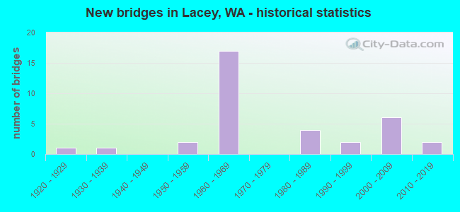
- New bridges - historical statistics
- 11920-1929
- 11930-1939
- 21950-1959
- 171960-1969
- 41980-1989
- 21990-1999
- 62000-2009
- 22010-2019
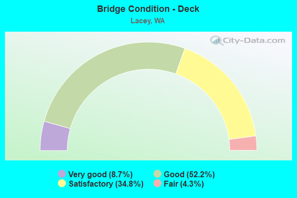
- Bridge Condition - Deck
- 8.7%Very good
- 52.2%Good
- 34.8%Satisfactory
- 4.3%Fair
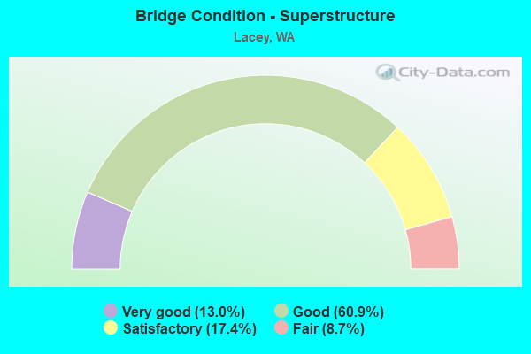
- Bridge Condition - Superstructure
- 13.0%Very good
- 60.9%Good
- 17.4%Satisfactory
- 8.7%Fair

- Bridge Condition - Substructure
- 8.7%Very good
- 60.9%Good
- 8.7%Satisfactory
- 21.7%Fair
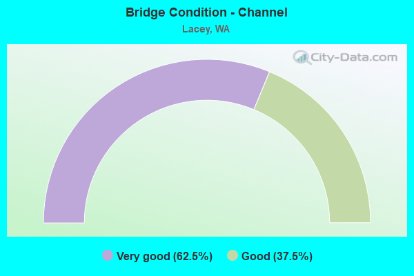
- Bridge Condition - Channel
- 62.5%Very good
- 37.5%Good
Find on map >> Show street view
Structure Number: 8100A, Location: 5.0 N JCT US 101 (Lat: 47.048639, Lng: -122.819222), Route carried "on" structure: Interstate 5, Year Built: 1967, Year Reconstructed: 1988, Status: Open, Structure Length: 8.41m (27.59ft), Average Daily Traffic: 50,462 (year 2019), Truck Traffic: 11%, Average Future Daily Traffic: 73,068 (year 2039), Design Load: HS 20+Mod, Features Intersected: MARTIN WAY
Minimum Vertical Clearance: 30+ m (98+ ft), Kilometerpoint: 175.612, Lanes on structure: 3, Lanes under structure: 6, Base Highway Network: Yes, Owner: State Highway Agency, Approaching Roadway Width: 15.8m (51.8ft), Skew: 5 degrees, Material/Design: Prestressed concrete, Design/Construction: Stringer/Multi-beam, Number Of Spans In Main Unit: 3, Length of Maximum Span: 40.8m (133.9ft), Curb-To-Curb Width: 15.8m (51.8ft), Out-to-Out Width: 16.8m (55.1ft)
Condition: Deck: Good, Superstructure: Fair, Substructure: Good, Operating Rating: 21.1 metric tons, Method Used To Determine Operating Rating: Load and Resistance Factor Rating (LRFR) rating reported by rating factor(RF) method using HL-93 loadings, Inventory Rating: 16.2 metric tons, Method Used To Determine Inventory Rating: Load and Resistance Factor Rating (LRFR) rating reported by rating factor(RF) method using HL-93 loadings, Structural Evaluation: Meets minimum limits, Deck Geometry: Somewhat better than minimum adequacy, Underclear: Meets minimum limits, Approach Roadway Alignment: Equal to present desirable criteria, Length Of Structure Improvement: 8.41m (27.59ft), Designated Inspection Frequency: Every 24 months, Inspection Date: November 2021, Bridge Improvement Cost: $2,981,000, Roadway Improvement Cost: $596,000, Total Project Cost: $5,962,000 ( Estimate for 2014), Deck Structure Type: Concrete Cast-file-Place, Wearing Surface/Protective System: Wearing Surface: Latex Concrete
Find on map >> Show street view
Structure Number: 8100B, Location: 5.0 N JCT US 101 (Lat: 47.048667, Lng: -122.818750), Route carried "on" structure: Interstate 5, Year Built: 1967, Year Reconstructed: 1988, Status: Open, Structure Length: 8.60m (28.22ft), Average Daily Traffic: 50,462 (year 2019), Truck Traffic: 11%, Average Future Daily Traffic: 73,068 (year 2039), Design Load: HS 20+Mod, Features Intersected: MARTIN WAY
Minimum Vertical Clearance: 30+ m (98+ ft), Kilometerpoint: 175.644, Lanes on structure: 3, Lanes under structure: 5, Base Highway Network: Yes, Owner: State Highway Agency, Approaching Roadway Width: 15.8m (51.8ft), Skew: 5 degrees, Material/Design: Prestressed concrete, Design/Construction: Stringer/Multi-beam, Number Of Spans In Main Unit: 3, Length of Maximum Span: 40.8m (133.9ft), Curb-To-Curb Width: 15.8m (51.8ft), Out-to-Out Width: 16.8m (55.1ft)
Condition: Deck: Satisfactory, Superstructure: Satisfactory, Substructure: Good, Operating Rating: 16.5 metric tons, Method Used To Determine Operating Rating: Load and Resistance Factor Rating (LRFR) rating reported by rating factor(RF) method using HL-93 loadings, Inventory Rating: 13.0 metric tons, Method Used To Determine Inventory Rating: Load and Resistance Factor Rating (LRFR) rating reported by rating factor(RF) method using HL-93 loadings, Structural Evaluation: High priority of corrective action, Deck Geometry: Somewhat better than minimum adequacy, Underclear: Meets minimum limits, Approach Roadway Alignment: Equal to present desirable criteria, Length Of Structure Improvement: 8.60m (28.22ft), Designated Inspection Frequency: Every 24 months, Inspection Date: November 2021, Bridge Improvement Cost: $3,046,000, Roadway Improvement Cost: $609,000, Total Project Cost: $6,091,000 ( Estimate for 2014), Deck Structure Type: Concrete Cast-file-Place, Wearing Surface/Protective System: Wearing Surface: Latex Concrete
Find on map >> Show street view
Structure Number: 8100C, Location: 6.4 N JCT US 101 (Lat: 47.057917, Lng: -122.796806), Route carried "on" structure: County highway , Year Built: 1967, Status: Open, Structure Length: 10.85m (35.60ft), Average Daily Traffic: 4,466 (year 2002), Truck Traffic: 2%, Average Future Daily Traffic: 8,110 (year 2036), Design Load: HS 20+Mod, Features Intersected: I-5, Facility Carried by Structure: CARPENTER RD
Minimum Vertical Clearance: 30+ m (98+ ft), Kilometerpoint: 7.323, Lanes on structure: 2, Lanes under structure: 6, Owner: State Highway Agency, Approaching Roadway Width: 7.9m (25.9ft), Material/Design: Prestressed concrete, Design/Construction: Stringer/Multi-beam, Number Of Spans In Main Unit: 4, Length of Maximum Span: 32.9m (107.9ft), Curb or Sidewalk Widths: Left: 0.9m (3.0ft), Right: 0.9m (3.0ft), Curb-To-Curb Width: 7.9m (25.9ft), Out-to-Out Width: 10.4m (34.1ft)
Condition: Deck: Satisfactory, Superstructure: Good, Substructure: Good, Operating Rating: 20.7 metric tons, Method Used To Determine Operating Rating: Load and Resistance Factor Rating (LRFR) rating reported by rating factor(RF) method using HL-93 loadings, Inventory Rating: 16.2 metric tons, Method Used To Determine Inventory Rating: Load and Resistance Factor Rating (LRFR) rating reported by rating factor(RF) method using HL-93 loadings, Structural Evaluation: Meets minimum limits, Deck Geometry: High priority of corrective action, Underclear: Equal to present desirable criteria, Approach Roadway Alignment: Equal to present desirable criteria, Length Of Structure Improvement: 10.85m (35.60ft), Designated Inspection Frequency: Every 24 months, Inspection Date: November 2021, Bridge Improvement Cost: $1,994,000, Roadway Improvement Cost: $399,000, Total Project Cost: $3,987,000 ( Estimate for 2014), Deck Structure Type: Concrete Cast-file-Place, Wearing Surface/Protective System: Wearing Surface: Monolithic Concrete
Find on map >> Show street view
Structure Number: 8100D, Location: 1.2 N JCT SR 510 (Lat: 47.066056, Lng: -122.741500), Route carried "on" structure: County highway , Year Built: 1968, Status: Open, Structure Length: 8.53m (27.99ft), Average Daily Traffic: 7,124 (year 2002), Truck Traffic: 1%, Average Future Daily Traffic: 9,788 (year 2036), Design Load: HS 20+Mod, Features Intersected: I-5, Facility Carried by Structure: MERIDIAN RD
Minimum Vertical Clearance: 30+ m (98+ ft), Kilometerpoint: 0.515, Lanes on structure: 2, Lanes under structure: 6, Owner: State Highway Agency, Approaching Roadway Width: 9.8m (32.2ft), Skew: 1 degrees, Material/Design: Prestressed concrete, Design/Construction: Stringer/Multi-beam, Number Of Spans In Main Unit: 4, Length of Maximum Span: 27.1m (88.9ft), Curb or Sidewalk Widths: Left: 0.5m (1.6ft), Right: 0.5m (1.6ft), Curb-To-Curb Width: 7.9m (25.9ft), Out-to-Out Width: 9.3m (30.5ft)
Condition: Deck: Good, Superstructure: Good, Substructure: Good, Operating Rating: 30.5 metric tons, Method Used To Determine Operating Rating: Load and Resistance Factor Rating (LRFR) rating reported by rating factor(RF) method using HL-93 loadings, Inventory Rating: 23.3 metric tons, Method Used To Determine Inventory Rating: Load and Resistance Factor Rating (LRFR) rating reported by rating factor(RF) method using HL-93 loadings, Structural Evaluation: Somewhat better than minimum adequacy, Deck Geometry: High priority of corrective action, Underclear: Equal to present minimum criteria, Approach Roadway Alignment: Equal to present desirable criteria, Length Of Structure Improvement: 8.53m (27.99ft), Designated Inspection Frequency: Every 24 months, Inspection Date: November 2021, Bridge Improvement Cost: $1,904,000, Roadway Improvement Cost: $381,000, Total Project Cost: $3,808,000 ( Estimate for 2014), Deck Structure Type: Concrete Cast-file-Place, Wearing Surface/Protective System: Wearing Surface: Monolithic Concrete
Find on map >> Show street view
Structure Number: 8100E, Location: 2.2 N JCT SR 510 (Lat: 47.067906, Lng: -122.720333), Route carried "on" structure: Interstate 5, Year Built: 1968, Status: Open, Structure Length: 8.29m (27.20ft), Average Daily Traffic: 51,349 (year 2019), Truck Traffic: 11%, Average Future Daily Traffic: 74,353 (year 2039), Design Load: HS 20+Mod, Features Intersected: MCALLISTER CR
Minimum Vertical Clearance: 30+ m (98+ ft), Kilometerpoint: 183.610, Lanes on structure: 3, Lanes under structure: 2, Base Highway Network: Yes, Owner: State Highway Agency, Approaching Roadway Width: 15.8m (51.8ft), Skew: 1 degrees, Material/Design: Prestressed concrete, Design/Construction: Stringer/Multi-beam, Number Of Spans In Main Unit: 3, Length of Maximum Span: 29.0m (95.1ft), Curb or Sidewalk Widths: Left: 0.2m (0.7ft), Right: 0.2m (0.7ft), Curb-To-Curb Width: 14.6m (47.9ft), Out-to-Out Width: 15.7m (51.5ft)
Condition: Deck: Good, Superstructure: Satisfactory, Substructure: Fair, Channel: Good, Operating Rating: 15.2 metric tons, Method Used To Determine Operating Rating: Load and Resistance Factor Rating (LRFR) rating reported by rating factor(RF) method using HL-93 loadings, Inventory Rating: 11.7 metric tons, Method Used To Determine Inventory Rating: Load and Resistance Factor Rating (LRFR) rating reported by rating factor(RF) method using HL-93 loadings, Structural Evaluation: High priority of corrective action, Deck Geometry: Meets minimum limits, Underclear: Somewhat better than minimum adequacy, Waterway Adequacy: Equal to present desirable criteria, Approach Roadway Alignment: Equal to present desirable criteria, Length Of Structure Improvement: 8.29m (27.20ft), Designated Inspection Frequency: Every 24 months, Inspection Date: June 2021, Bridge Improvement Cost: $2,938,000, Roadway Improvement Cost: $588,000, Total Project Cost: $5,875,000 ( Estimate for 2014), Deck Structure Type: Concrete Cast-file-Place, Wearing Surface/Protective System: Wearing Surface: Monolithic Concrete
Find on map >> Show street view
Structure Number: 8100F, Location: 2.2 N JCT SR 510 (Lat: 47.068139, Lng: -122.720250), Route carried "on" structure: Interstate 5, Year Built: 1968, Status: Open, Structure Length: 8.29m (27.20ft), Average Daily Traffic: 51,349 (year 2019), Truck Traffic: 11%, Average Future Daily Traffic: 74,353 (year 2039), Design Load: HS 20+Mod, Features Intersected: MCALLISTER CREEK
Minimum Vertical Clearance: 30+ m (98+ ft), Kilometerpoint: 183.610, Lanes on structure: 3, Lanes under structure: 2, Base Highway Network: Yes, Owner: State Highway Agency, Approaching Roadway Width: 15.8m (51.8ft), Skew: 1 degrees, Material/Design: Prestressed concrete, Design/Construction: Stringer/Multi-beam, Number Of Spans In Main Unit: 3, Length of Maximum Span: 28.0m (91.9ft), Curb or Sidewalk Widths: Left: 0.2m (0.7ft), Right: 0.2m (0.7ft), Curb-To-Curb Width: 14.6m (47.9ft), Out-to-Out Width: 15.7m (51.5ft)
Condition: Deck: Satisfactory, Superstructure: Good, Substructure: Satisfactory, Channel: Good, Operating Rating: 15.2 metric tons, Method Used To Determine Operating Rating: Load and Resistance Factor Rating (LRFR) rating reported by rating factor(RF) method using HL-93 loadings, Inventory Rating: 11.7 metric tons, Method Used To Determine Inventory Rating: Load and Resistance Factor Rating (LRFR) rating reported by rating factor(RF) method using HL-93 loadings, Structural Evaluation: High priority of corrective action, Deck Geometry: Meets minimum limits, Underclear: Somewhat better than minimum adequacy, Waterway Adequacy: Equal to present desirable criteria, Approach Roadway Alignment: Equal to present desirable criteria, Length Of Structure Improvement: 8.29m (27.20ft), Designated Inspection Frequency: Every 48 months, Inspection Date: September 2018, Bridge Improvement Cost: $2,938,000, Roadway Improvement Cost: $588,000, Total Project Cost: $5,875,000 ( Estimate for 2014), Deck Structure Type: Concrete Cast-file-Place, Wearing Surface/Protective System: Wearing Surface: Monolithic Concrete
Find on map >> Show street view
Structure Number: 8100G, Location: 2.2 N JCT SR 510 (Lat: 47.067356, Lng: -122.721000), Route carried "on" structure: Ramp Interstate 5, Year Built: 1968, Status: Open, Structure Length: 6.58m (21.59ft), Average Daily Traffic: 2,115 (year 2019), Truck Traffic: 11%, Average Future Daily Traffic: 3,062 (year 2039), Design Load: HS 20+Mod, Features Intersected: MCALLISTER CR
Minimum Vertical Clearance: 30+ m (98+ ft), Kilometerpoint: 0.338, Lanes on structure: 1, Owner: State Highway Agency, Approaching Roadway Width: 7.9m (25.9ft), Skew: 4 degrees, Material/Design: Concrete continuous, Design/Construction: Slab, Number Of Spans In Main Unit: 6, Length of Maximum Span: 11.9m (39.0ft), Curb-To-Curb Width: 7.0m (23.0ft), Out-to-Out Width: 8.0m (26.2ft)
Condition: Deck: Good, Superstructure: Good, Substructure: Good, Channel: Good, Operating Rating: 45.4 metric tons, Method Used To Determine Operating Rating: Load and Resistance Factor Rating (LRFR) rating reported by rating factor(RF) method using HL-93 loadings, Inventory Rating: 35.0 metric tons, Method Used To Determine Inventory Rating: Load and Resistance Factor Rating (LRFR) rating reported by rating factor(RF) method using HL-93 loadings, Structural Evaluation: Better than present minimum criteria, Deck Geometry: Equal to present minimum criteria, Waterway Adequacy: Equal to present desirable criteria, Approach Roadway Alignment: Equal to present desirable criteria, Length Of Structure Improvement: 6.58m (21.59ft), Designated Inspection Frequency: Every 24 months, Inspection Date: June 2021, Bridge Improvement Cost: $1,210,000, Roadway Improvement Cost: $242,000, Total Project Cost: $2,419,000 ( Estimate for 2014), Deck Structure Type: Concrete Cast-file-Place, Wearing Surface/Protective System: Wearing Surface: Monolithic Concrete
Find on map >> Show street view
Structure Number: 8100H, Location: 2.2 N JCT SR 510 (Lat: 47.068806, Lng: -122.719583), Route carried "on" structure: Ramp Interstate 5, Year Built: 1968, Status: Open, Structure Length: 5.12m (16.80ft), Average Daily Traffic: 2,079 (year 2019), Truck Traffic: 8%, Average Future Daily Traffic: 3,010 (year 2039), Design Load: HS 20+Mod, Features Intersected: MCALLISTER CR
Minimum Vertical Clearance: 30+ m (98+ ft), Kilometerpoint: 0.032, Lanes on structure: 1, Owner: State Highway Agency, Approaching Roadway Width: 7.3m (24.0ft), Skew: 9 degrees, Material/Design: Concrete continuous, Design/Construction: Slab, Number Of Spans In Main Unit: 5, Length of Maximum Span: 11.6m (38.1ft), Curb or Sidewalk Widths: Left: 0.2m (0.7ft), Right: 0.2m (0.7ft), Curb-To-Curb Width: 7.0m (23.0ft), Out-to-Out Width: 8.2m (26.9ft)
Condition: Deck: Good, Superstructure: Good, Substructure: Fair, Channel: Good, Operating Rating: 43.7 metric tons, Method Used To Determine Operating Rating: Load and Resistance Factor Rating (LRFR) rating reported by rating factor(RF) method using HL-93 loadings, Inventory Rating: 33.7 metric tons, Method Used To Determine Inventory Rating: Load and Resistance Factor Rating (LRFR) rating reported by rating factor(RF) method using HL-93 loadings, Structural Evaluation: Somewhat better than minimum adequacy, Deck Geometry: Equal to present minimum criteria, Waterway Adequacy: Equal to present desirable criteria, Approach Roadway Alignment: Equal to present desirable criteria, Length Of Structure Improvement: 5.12m (16.80ft), Designated Inspection Frequency: Every 24 months, Inspection Date: May 2020, Bridge Improvement Cost: $874,000, Roadway Improvement Cost: $175,000, Total Project Cost: $1,747,000 ( Estimate for 2014), Deck Structure Type: Concrete Cast-file-Place, Wearing Surface/Protective System: Wearing Surface: Monolithic Concrete
Find on map >> Show street view
Structure Number: 8100I, Location: 2.4 N JCT SR 510 (Lat: 47.068333, Lng: -122.715500), Route carried "on" structure: Ramp Interstate 5, Year Built: 1968, Status: Open, Structure Length: 11.25m (36.91ft), Average Daily Traffic: 8,626 (year 2019), Truck Traffic: 4%, Average Future Daily Traffic: 12,490 (year 2039), Design Load: HS 20+Mod, Features Intersected: I-5 MAINLINE
Minimum Vertical Clearance: 30+ m (98+ ft), Kilometerpoint: 0.402, Lanes on structure: 1, Lanes under structure: 6, Owner: State Highway Agency, Approaching Roadway Width: 8.2m (26.9ft), Material/Design: Concrete continuous, Design/Construction: Box Beam or Girders - Multiple, Number Of Spans In Main Unit: 4, Length of Maximum Span: 32.9m (107.9ft), Curb or Sidewalk Widths: Left: 0.2m (0.7ft), Right: 0.2m (0.7ft), Curb-To-Curb Width: 7.0m (23.0ft), Out-to-Out Width: 8.2m (26.9ft)
Condition: Deck: Satisfactory, Superstructure: Good, Substructure: Good, Operating Rating: 89.8 metric tons, Method Used To Determine Operating Rating: Load Factor (LF), Inventory Rating: 65.3 metric tons, Method Used To Determine Inventory Rating: Load Factor (LF), Structural Evaluation: Better than present minimum criteria, Deck Geometry: Equal to present minimum criteria, Underclear: Meets minimum limits, Approach Roadway Alignment: Equal to present minimum criteria, Length Of Structure Improvement: 11.25m (36.91ft), Designated Inspection Frequency: Every 24 months, Inspection Date: November 2021, Bridge Improvement Cost: $2,140,000, Roadway Improvement Cost: $428,000, Total Project Cost: $4,280,000 ( Estimate for 2014), Deck Structure Type: Concrete Cast-file-Place, Wearing Surface/Protective System: Wearing Surface: Epoxy Overlay
Find on map >> Show street view
Structure Number: 8100J, Location: 2.7 N JCT SR 510 (Lat: 47.069111, Lng: -122.711333), Route carried "on" structure: Interstate 5, Year Built: 1968, Status: Open, Structure Length: 6.10m (20.01ft), Average Daily Traffic: 51,349 (year 2019), Truck Traffic: 11%, Average Future Daily Traffic: 74,353 (year 2039), Design Load: HS 20+Mod, Features Intersected: NISQUALLY OVERFLOW
Minimum Vertical Clearance: 30+ m (98+ ft), Kilometerpoint: 184.334, Lanes on structure: 4, Base Highway Network: Yes, Owner: State Highway Agency, Approaching Roadway Width: 16.8m (55.1ft), Material/Design: Prestressed concrete, Design/Construction: Stringer/Multi-beam, Number Of Spans In Main Unit: 2, Length of Maximum Span: 30.5m (100.1ft), Curb or Sidewalk Widths: Left: 0.2m (0.7ft), Right: 0.2m (0.7ft), Curb-To-Curb Width: 15.8m (51.8ft), Out-to-Out Width: 16.9m (55.4ft)
Condition: Deck: Satisfactory, Superstructure: Good, Substructure: Good, Channel: Very good, Operating Rating: 25.3 metric tons, Method Used To Determine Operating Rating: Load and Resistance Factor Rating (LRFR) rating reported by rating factor(RF) method using HL-93 loadings, Inventory Rating: 19.4 metric tons, Method Used To Determine Inventory Rating: Load and Resistance Factor Rating (LRFR) rating reported by rating factor(RF) method using HL-93 loadings, Structural Evaluation: Meets minimum limits, Deck Geometry: Meets minimum limits, Waterway Adequacy: Equal to present desirable criteria, Approach Roadway Alignment: Equal to present desirable criteria, Length Of Structure Improvement: 6.10m (20.01ft), Designated Inspection Frequency: Every 24 months, Inspection Date: November 2021, Bridge Improvement Cost: $2,280,000, Roadway Improvement Cost: $456,000, Total Project Cost: $4,560,000 ( Estimate for 2014), Deck Structure Type: Concrete Cast-file-Place, Wearing Surface/Protective System: Wearing Surface: Latex Concrete
Find on map >> Show street view
Structure Number: 12137A, Location: 2.7 N JCT SR 510 (Lat: 47.068833, Lng: -122.710972), Route carried "on" structure: Interstate 5, Year Built: 1982, Status: Open, Structure Length: 6.10m (20.01ft), Average Daily Traffic: 51,349 (year 2019), Truck Traffic: 11%, Average Future Daily Traffic: 74,353 (year 2039), Design Load: HS 20+Mod, Features Intersected: NISQUALLY OVERFLOW-SOUTH
Minimum Vertical Clearance: 30+ m (98+ ft), Kilometerpoint: 184.334, Lanes on structure: 3, Base Highway Network: Yes, Owner: State Highway Agency, Approaching Roadway Width: 18.6m (61.0ft), Material/Design: Prestressed concrete continuous, Design/Construction: Stringer/Multi-beam, Number Of Spans In Main Unit: 2, Length of Maximum Span: 30.5m (100.1ft), Curb-To-Curb Width: 17.6m (57.7ft), Out-to-Out Width: 18.3m (60.0ft)
Condition: Deck: Satisfactory, Superstructure: Good, Substructure: Good, Channel: Very good, Operating Rating: 59.0 metric tons, Method Used To Determine Operating Rating: Load Factor (LF), Inventory Rating: 35.4 metric tons, Method Used To Determine Inventory Rating: Load Factor (LF), Structural Evaluation: Better than present minimum criteria, Deck Geometry: Better than present minimum criteria, Waterway Adequacy: Equal to present desirable criteria, Approach Roadway Alignment: Equal to present desirable criteria, Length Of Structure Improvement: 6.10m (20.01ft), Designated Inspection Frequency: Every 24 months, Inspection Date: November 2021, Bridge Improvement Cost: $2,520,000, Roadway Improvement Cost: $504,000, Total Project Cost: $5,040,000 ( Estimate for 2014), Deck Structure Type: Concrete Cast-file-Place, Wearing Surface/Protective System: Wearing Surface: Monolithic Concrete, Deck Protection: Epoxy Coated Reinforcing
Find on map >> Show street view
Structure Number: 13130A, Location: 4.8 N JCT US 101 (Lat: 47.047139, Lng: -122.823222), Route carried "on" structure: City street , Year Built: 1988, Status: Open, Structure Length: 6.19m (20.31ft), Average Daily Traffic: 31,602 (year 2002), Truck Traffic: 2%, Average Future Daily Traffic: 60,613 (year 2036), Design Load: HS 20+Mod, Features Intersected: I-5, Facility Carried by Structure: COLLEGE ST
Minimum Vertical Clearance: 30+ m (98+ ft), Kilometerpoint: 10.525, Lanes on structure: 5, Lanes under structure: 7, Base Highway Network: Yes, Owner: State Highway Agency, Approaching Roadway Width: 18.6m (61.0ft), Skew: 1 degrees, Material/Design: Prestressed concrete continuous, Design/Construction: Box Beam or Girders - Single/Spread, Number Of Spans In Main Unit: 2, Length of Maximum Span: 34.1m (111.9ft), Curb or Sidewalk Widths: Left: 1.8m (5.9ft), Right: 1.8m (5.9ft), Curb-To-Curb Width: 18.7m (61.4ft), Out-to-Out Width: 22.9m (75.1ft)
Condition: Deck: Good, Superstructure: Good, Substructure: Good, Operating Rating: 89.8 metric tons, Method Used To Determine Operating Rating: Load Factor (LF), Inventory Rating: 63.5 metric tons, Method Used To Determine Inventory Rating: Load Factor (LF), Structural Evaluation: Better than present minimum criteria, Deck Geometry: High priority of corrective action, Underclear: Equal to present minimum criteria, Approach Roadway Alignment: Equal to present desirable criteria, Length Of Structure Improvement: 6.19m (20.31ft), Designated Inspection Frequency: Every 48 months, Inspection Date: September 2018, Bridge Improvement Cost: $2,558,000, Roadway Improvement Cost: $512,000, Total Project Cost: $5,116,000 ( Estimate for 2014), Deck Structure Type: Concrete Cast-file-Place, Wearing Surface/Protective System: Wearing Surface: Monolithic Concrete
Find on map >> Show street view
Structure Number: 15774A, Location: JCT I-5 (Lat: 47.063806, Lng: -122.765389), Route carried "on" structure: State highway 510, Year Built: 2001, Year Reconstructed: 2021, Status: Open, Structure Length: 6.46m (21.19ft), Average Daily Traffic: 34,370 (year 2019), Truck Traffic: 6%, Average Future Daily Traffic: 49,767 (year 2039), Design Load: HS 25 or greater, Features Intersected: I-5
Minimum Vertical Clearance: 30+ m (98+ ft), Kilometerpoint: 0.016, Lanes on structure: 6, Lanes under structure: 6, Base Highway Network: Yes, Owner: State Highway Agency, Approaching Roadway Width: 31.1m (102.0ft), Skew: 30 degrees, Material/Design: Concrete continuous, Design/Construction: Box Beam or Girders - Multiple, Number Of Spans In Main Unit: 2, Length of Maximum Span: 41.8m (137.1ft), Curb-To-Curb Width: 31.1m (102.0ft), Out-to-Out Width: 34.1m (111.9ft)
Condition: Deck: Good, Superstructure: Good, Substructure: Good, Operating Rating: 89.8 metric tons, Method Used To Determine Operating Rating: Load Factor (LF), Inventory Rating: 82.5 metric tons, Method Used To Determine Inventory Rating: Load Factor (LF), Structural Evaluation: Better than present minimum criteria, Deck Geometry: Superior to present desirable criteria, Underclear: Meets minimum limits, Approach Roadway Alignment: Equal to present desirable criteria, Length Of Structure Improvement: 6.46m (21.19ft), Designated Inspection Frequency: Every 24 months, Inspection Date: November 2021, Bridge Improvement Cost: $4,410,000, Roadway Improvement Cost: $882,000, Total Project Cost: $8,819,000 ( Estimate for 2014), Deck Structure Type: Concrete Cast-file-Place, Wearing Surface/Protective System: Wearing Surface: Monolithic Concrete, Deck Protection: Epoxy Coated Reinforcing
Find on map >> Show street view
Structure Number: 80067, Location: Lacey Cily Limit (Lat: 46.990556, Lng: -122.796850), Route carried "on" structure: County highway 15725, Year Built: 1951, Status: Open, Structure Length: 5.58m (18.31ft), Average Daily Traffic: 12,500 (year 2020), Truck Traffic: 15%, Average Future Daily Traffic: 20,105 (year 2042), Design Load: HS 20, Features Intersected: RAILROAD, Facility Carried by Structure: YELM HWY S.E.
Minimum Vertical Clearance: 30+ m (98+ ft), Kilometerpoint: 9.753, Lanes on structure: 2, Base Highway Network: Yes, Owner: County Highway Agency, Approaching Roadway Width: 21.3m (69.9ft), Skew: 3 degrees, Material/Design: Concrete continuous, Design/Construction: Tee Beam, Number Of Spans In Main Unit: 3, Length of Maximum Span: 25.6m (84.0ft), Curb or Sidewalk Widths: Left: 0.8m (2.6ft), Right: 0.8m (2.6ft), Curb-To-Curb Width: 7.9m (25.9ft), Out-to-Out Width: 9.6m (31.5ft)
Condition: Deck: Fair, Superstructure: Fair, Substructure: Fair, Operating Rating: 33.6 metric tons, Method Used To Determine Operating Rating: Load Factor (LF), Inventory Rating: 20.0 metric tons, Method Used To Determine Inventory Rating: Load Factor (LF), Structural Evaluation: Somewhat better than minimum adequacy, Deck Geometry: High priority of replacement, Underclear: Meets minimum limits, Approach Roadway Alignment: Equal to present minimum criteria, Length Of Structure Improvement: 5.58m (18.31ft), Designated Inspection Frequency: Every 24 months, Inspection Date: May 2020, Bridge Improvement Cost: $555,000, Roadway Improvement Cost: $222,000, Total Project Cost: $999,000 ( Estimate for 2016), Deck Structure Type: Concrete Cast-file-Place, Wearing Surface/Protective System: Wearing Surface: Monolithic Concrete
Find on map >> Show street view
Structure Number: 80616, Location: .2 E JCT I5 (Lat: 47.067647, Lng: -122.714372), Route carried "on" structure: County highway 13585, Year Built: 1936, Status: Open, Structure Length: 2.80m (9.19ft), Average Daily Traffic: 5,226 (year 2020), Truck Traffic: 25%, Average Future Daily Traffic: 8,079 (year 2042), Design Load: HL 93, Features Intersected: OVERFLOW CHANNEL, Facility Carried by Structure: NISQUALLY CUTOFF
Minimum Vertical Clearance: 30+ m (98+ ft), Kilometerpoint: 0.001, Lanes on structure: 2, Owner: County Highway Agency, Approaching Roadway Width: 9.8m (32.2ft), Material/Design: Concrete, Design/Construction: Tee Beam, Number Of Spans In Main Unit: 3, Length of Maximum Span: 9.1m (29.9ft), Curb or Sidewalk Widths: Left: 0.0m, Right: 1.1m (3.6ft), Curb-To-Curb Width: 13.4m (44.0ft), Out-to-Out Width: 15.4m (50.5ft)
Condition: Deck: Good, Superstructure: Satisfactory, Substructure: Fair, Channel: Very good, Operating Rating: 32.7 metric tons, Method Used To Determine Operating Rating: Field evaluation and documented engineering judgment, Inventory Rating: 31.7 metric tons, Method Used To Determine Inventory Rating: Field evaluation and documented engineering judgment, Structural Evaluation: Somewhat better than minimum adequacy, Deck Geometry: Equal to present minimum criteria, Waterway Adequacy: Equal to present desirable criteria, Approach Roadway Alignment: Equal to present minimum criteria, Length Of Structure Improvement: 2.80m (9.19ft), Designated Inspection Frequency: Every 24 months, Inspection Date: June 2020, Bridge Improvement Cost: $626,000, Roadway Improvement Cost: $125,000, Total Project Cost: $1,251,000 ( Estimate for 2014), Deck Structure Type: Concrete Cast-file-Place, Wearing Surface/Protective System: Wearing Surface: Monolithic Concrete
Find on map >> Show street view
Structure Number: 8239, Location: 2.0 m S of I-5 on ramp (Lat: 47.049969, Lng: -122.726486), Route carried "on" structure: County highway 14830, Year Built: 1964, Status: Open, Structure Length: 3.90m (12.80ft), Average Daily Traffic: 1,384 (year 2019), Truck Traffic: 15%, Average Future Daily Traffic: 2,140 (year 2041), Design Load: HS 20, Features Intersected: MCALLISTER CREEK, Facility Carried by Structure: STEILACOOM ROAD
Minimum Vertical Clearance: 30+ m (98+ ft), Kilometerpoint: 0.001, Lanes on structure: 2, Owner: County Highway Agency, Approaching Roadway Width: 8.2m (26.9ft), Material/Design: Concrete continuous, Design/Construction: Slab, Number Of Spans In Main Unit: 4, Length of Maximum Span: 11.0m (36.1ft), Curb-To-Curb Width: 7.4m (24.3ft), Out-to-Out Width: 8.0m (26.2ft)
Condition: Deck: Good, Superstructure: Good, Substructure: Fair, Channel: Good, Operating Rating: 61.7 metric tons, Method Used To Determine Operating Rating: Load Factor (LF), Inventory Rating: 36.3 metric tons, Method Used To Determine Inventory Rating: Load Factor (LF), Structural Evaluation: Somewhat better than minimum adequacy, Deck Geometry: Meets minimum limits, Waterway Adequacy: Better than present minimum criteria, Approach Roadway Alignment: Equal to present minimum criteria, Length Of Structure Improvement: 4.21m (13.81ft), Designated Inspection Frequency: Every 24 months, Inspection Date: October 2021, Bridge Improvement Cost: $2,098,000, Roadway Improvement Cost: $420,000, Total Project Cost: $4,195,000 ( Estimate for 2014), Deck Structure Type: Concrete Cast-file-Place
Find on map >> Show street view
Structure Number: 82954, Location: OVER LONG LAKE (Lat: 47.025022, Lng: -122.782697), Route carried "on" structure: County highway 12230, Year Built: 1962, Status: Posted for load, Structure Length: 1.62m (5.31ft), Average Daily Traffic: 177 (year 2021), Truck Traffic: 15%, Average Future Daily Traffic: 284 (year 2043), Design Load: H 20, Features Intersected: LONG LAKE, Facility Carried by Structure: HOLMES ISD RD
Minimum Vertical Clearance: 30+ m (98+ ft), Kilometerpoint: 0.001, Lanes on structure: 2, Owner: County Highway Agency, Approaching Roadway Width: 6.1m (20.0ft), Material/Design: Concrete, Design/Construction: Channel Beam, Number Of Spans In Main Unit: 3, Length of Maximum Span: 7.0m (23.0ft), Curb-To-Curb Width: 5.7m (18.7ft), Out-to-Out Width: 6.2m (20.3ft)
Condition: Deck: Satisfactory, Superstructure: Satisfactory, Substructure: Satisfactory, Channel: Good, Operating Rating: 21.8 metric tons, Method Used To Determine Operating Rating: Load Factor (LF), Inventory Rating: 16.3 metric tons, Method Used To Determine Inventory Rating: Load Factor (LF), Structural Evaluation: Somewhat better than minimum adequacy, Deck Geometry: High priority of corrective action, Waterway Adequacy: Better than present minimum criteria, Approach Roadway Alignment: Equal to present minimum criteria, Bridge Posting: Required (Relationship of Operating Rating to Maximum Legal Load: 30.0 - 39.9% below), Length Of Structure Improvement: 1.92m (6.30ft), Designated Inspection Frequency: Every 12 months, Inspection Date: July 2021, Bridge Improvement Cost: $958,000, Roadway Improvement Cost: $192,000, Total Project Cost: $1,915,000 ( Estimate for 2014), Deck Structure Type: Concrete Precast Panels, Wearing Surface/Protective System: Wearing Surface: Bituminous
Find on map >> Show street view
Structure Number: 84511, Location: 2.5 m E of Hwy 99 (Lat: 46.920164, Lng: -122.810089), Route carried "on" structure: County highway 15410, Year Built: 1986, Status: Open, Structure Length: 4.57m (14.99ft), Average Daily Traffic: 1,957 (year 2020), Truck Traffic: 15%, Average Future Daily Traffic: 3,025 (year 2042), Design Load: HS 20, Features Intersected: DESCHUTES RIVER, Facility Carried by Structure: WALDRICK ROAD
Minimum Vertical Clearance: 30+ m (98+ ft), Kilometerpoint: 0.001, Lanes on structure: 2, Owner: County Highway Agency, Approaching Roadway Width: 11.0m (36.1ft), Skew: 2 degrees, Material/Design: Prestressed concrete, Design/Construction: Stringer/Multi-beam, Number Of Spans In Main Unit: 1, Length of Maximum Span: 44.2m (145.0ft), Curb-To-Curb Width: 10.4m (34.1ft), Out-to-Out Width: 10.9m (35.8ft)
Condition: Deck: Good, Superstructure: Very good, Substructure: Good, Channel: Very good, Operating Rating: 89.8 metric tons, Method Used To Determine Operating Rating: Load Factor (LF), Inventory Rating: 68.9 metric tons, Method Used To Determine Inventory Rating: Load Factor (LF), Structural Evaluation: Better than present minimum criteria, Deck Geometry: Equal to present minimum criteria, Waterway Adequacy: Equal to present desirable criteria, Approach Roadway Alignment: Equal to present desirable criteria, Length Of Structure Improvement: 4.88m (16.01ft), Designated Inspection Frequency: Every 24 months, Inspection Date: October 2020, Bridge Improvement Cost: $2,432,000, Roadway Improvement Cost: $486,000, Total Project Cost: $4,864,000 ( Estimate for 2014), Deck Structure Type: Concrete Cast-file-Place, Wearing Surface/Protective System: Wearing Surface: Monolithic Concrete, Deck Protection: Epoxy Coated Reinforcing
Find on map >> Show street view
Structure Number: 86522, Location: .23 m SW of Nisqually Cu (Lat: 47.064825, Lng: -122.724253), Route carried "on" structure: County highway 13190, Year Built: 2000, Status: Open, Structure Length: 3.60m (11.81ft), Average Daily Traffic: 17,895 (year 2020), Truck Traffic: 15%, Average Future Daily Traffic: 27,665 (year 2042), Design Load: HS 20, Features Intersected: MC ALLISTER CREEK, Facility Carried by Structure: MARTIN WAY EAST
Minimum Vertical Clearance: 30+ m (98+ ft), Kilometerpoint: 11.314, Lanes on structure: 5, Base Highway Network: Yes, Owner: County Highway Agency, Approaching Roadway Width: 21.6m (70.9ft), Material/Design: Concrete continuous, Design/Construction: Slab, Number Of Spans In Main Unit: 3, Length of Maximum Span: 14.0m (45.9ft), Curb-To-Curb Width: 21.6m (70.9ft), Out-to-Out Width: 22.3m (73.2ft)
Condition: Deck: Satisfactory, Superstructure: Good, Substructure: Good, Channel: Very good, Operating Rating: 74.4 metric tons, Method Used To Determine Operating Rating: Load Factor (LF), Inventory Rating: 44.4 metric tons, Method Used To Determine Inventory Rating: Load Factor (LF), Structural Evaluation: Better than present minimum criteria, Deck Geometry: Somewhat better than minimum adequacy, Waterway Adequacy: Better than present minimum criteria, Approach Roadway Alignment: Equal to present desirable criteria, Length Of Structure Improvement: 3.90m (12.80ft), Designated Inspection Frequency: Every 24 months, Inspection Date: September 2020, Bridge Improvement Cost: $3,789,000, Roadway Improvement Cost: $758,000, Total Project Cost: $7,578,000 ( Estimate for 2014), Deck Structure Type: Concrete Cast-file-Place, Wearing Surface/Protective System: Wearing Surface: Monolithic Concrete, Deck Protection: Epoxy Coated Reinforcing
Find on map >> Show street view
Structure Number: 86523, Location: .19 m SW of Nisqually Cut (Lat: 47.065147, Lng: -122.722611), Route carried "on" structure: County highway 13190, Year Built: 2000, Status: Open, Structure Length: 3.60m (11.81ft), Average Daily Traffic: 17,895 (year 2020), Truck Traffic: 15%, Average Future Daily Traffic: 27,665 (year 2042), Design Load: HS 20, Features Intersected: SLOUGH, Facility Carried by Structure: MARTIN WAY E
Minimum Vertical Clearance: 30+ m (98+ ft), Kilometerpoint: 11.442, Lanes on structure: 5, Base Highway Network: Yes, Owner: County Highway Agency, Approaching Roadway Width: 21.6m (70.9ft), Material/Design: Concrete continuous, Design/Construction: Slab, Number Of Spans In Main Unit: 3, Length of Maximum Span: 14.0m (45.9ft), Curb-To-Curb Width: 21.6m (70.9ft), Out-to-Out Width: 22.3m (73.2ft)
Condition: Deck: Good, Superstructure: Good, Substructure: Good, Channel: Very good, Operating Rating: 74.4 metric tons, Method Used To Determine Operating Rating: Load Factor (LF), Inventory Rating: 44.4 metric tons, Method Used To Determine Inventory Rating: Load Factor (LF), Structural Evaluation: Better than present minimum criteria, Deck Geometry: Somewhat better than minimum adequacy, Waterway Adequacy: Equal to present desirable criteria, Approach Roadway Alignment: Equal to present desirable criteria, Length Of Structure Improvement: 3.90m (12.80ft), Designated Inspection Frequency: Every 24 months, Inspection Date: September 2020, Bridge Improvement Cost: $3,789,000, Roadway Improvement Cost: $758,000, Total Project Cost: $7,578,000 ( Estimate for 2014), Deck Structure Type: Concrete Cast-file-Place, Wearing Surface/Protective System: Wearing Surface: Monolithic Concrete, Deck Protection: Epoxy Coated Reinforcing
Find on map >> Show street view
Structure Number: 86526, Location: .7 mi. W of Marvin Rd (Lat: 47.003472, Lng: -122.768894), Route carried "on" structure: County highway 13490, Year Built: 1999, Status: Open, Structure Length: 2.80m (9.19ft), Average Daily Traffic: 7,703 (year 2021), Truck Traffic: 15%, Average Future Daily Traffic: 11,909 (year 2043), Design Load: HS 20, Features Intersected: CREEK, Facility Carried by Structure: Mullen Road
Minimum Vertical Clearance: 3.66m (12.01ft), Kilometerpoint: 0.001, Lanes on structure: 2, Owner: County Highway Agency, Approaching Roadway Width: 11.0m (36.1ft), Skew: 3 degrees, Material/Design: Prestressed concrete, Design/Construction: Slab, Number Of Spans In Main Unit: 2, Length of Maximum Span: 14.0m (45.9ft), Curb or Sidewalk Widths: Left: 1.5m (4.9ft), Right: 1.5m (4.9ft), Curb-To-Curb Width: 7.8m (25.6ft), Out-to-Out Width: 11.0m (36.1ft)
Condition: Deck: Good, Superstructure: Good, Substructure: Good, Channel: Very good, Operating Rating: 88.0 metric tons, Method Used To Determine Operating Rating: Load Factor (LF), Inventory Rating: 52.6 metric tons, Method Used To Determine Inventory Rating: Load Factor (LF), Structural Evaluation: Better than present minimum criteria, Deck Geometry: High priority of replacement, Waterway Adequacy: Meets minimum limits, Approach Roadway Alignment: High priority of corrective action, Length Of Structure Improvement: 3.11m (10.20ft), Designated Inspection Frequency: Every 24 months, Inspection Date: August 2021, Bridge Improvement Cost: $1,550,000, Roadway Improvement Cost: $310,000, Total Project Cost: $3,101,000 ( Estimate for 2014), Deck Structure Type: Concrete Precast Panels, Wearing Surface/Protective System: Wearing Surface: Bituminous, Membrane: Preformed Fabric, Deck Protection: Epoxy Coated Reinforcing
Find on map >> Show street view
Structure Number: 86641, Location: 1 MILE E DUTERROW INT (Lat: 47.051633, Lng: -122.721392), Route carried "on" structure: County highway 14830, Year Built: 2001, Status: Open, Structure Length: 0.88m (2.89ft), Average Daily Traffic: 1,001 (year 2020), Truck Traffic: 10%, Average Future Daily Traffic: 1,548 (year 2042), Design Load: HS 20, Features Intersected: HARTMAN CREEK, Facility Carried by Structure: STEIACOOM ROAD
Minimum Vertical Clearance: 30+ m (98+ ft), Kilometerpoint: 0.001, Lanes on structure: 2, Owner: County Highway Agency, Approaching Roadway Width: 9.1m (29.9ft), Material/Design: Prestressed concrete, Design/Construction: Slab, Number Of Spans In Main Unit: 1, Length of Maximum Span: 8.5m (27.9ft), Curb-To-Curb Width: 9.1m (29.9ft), Out-to-Out Width: 9.8m (32.2ft)
Condition: Deck: Very good, Superstructure: Very good, Substructure: Very good, Channel: Very good, Operating Rating: 78.0 metric tons, Method Used To Determine Operating Rating: Load Factor (LF), Inventory Rating: 46.3 metric tons, Method Used To Determine Inventory Rating: Load Factor (LF), Structural Evaluation: Equal to present desirable criteria, Deck Geometry: Somewhat better than minimum adequacy, Waterway Adequacy: Better than present minimum criteria, Approach Roadway Alignment: Equal to present desirable criteria, Length Of Structure Improvement: 1.19m (3.90ft), Designated Inspection Frequency: Every 24 months, Inspection Date: October 2020, Bridge Improvement Cost: $593,000, Roadway Improvement Cost: $119,000, Total Project Cost: $1,186,000 ( Estimate for 2014), Deck Structure Type: Concrete Precast Panels, Wearing Surface/Protective System: Wearing Surface: Bituminous, Deck Protection: Epoxy Coated Reinforcing
Find on map >> Show street view
Structure Number: 87081, Location: 0.85 m E of SleaterKinney (Lat: 47.071744, Lng: -122.817386), Route carried "on" structure: County highway 14000, Year Built: 2003, Status: Open, Structure Length: 1.55m (5.09ft), Average Daily Traffic: 420 (year 2020), Truck Traffic: 10%, Average Future Daily Traffic: 649 (year 2042), Design Load: HS 20, Features Intersected: WOODLAND CREEK, Facility Carried by Structure: PLEASANT GLADE RD
Minimum Vertical Clearance: 30+ m (98+ ft), Kilometerpoint: 0.001, Lanes on structure: 2, Owner: County Highway Agency, Approaching Roadway Width: 7.3m (24.0ft), Material/Design: Prestressed concrete, Design/Construction: Slab, Number Of Spans In Main Unit: 1, Length of Maximum Span: 15.2m (49.9ft), Curb-To-Curb Width: 6.9m (22.6ft), Out-to-Out Width: 7.3m (24.0ft)
Condition: Deck: Very good, Superstructure: Very good, Substructure: Very good, Channel: Very good, Operating Rating: 78.9 metric tons, Method Used To Determine Operating Rating: Load Factor (LF), Inventory Rating: 48.1 metric tons, Method Used To Determine Inventory Rating: Load Factor (LF), Structural Evaluation: Equal to present desirable criteria, Deck Geometry: Meets minimum limits, Waterway Adequacy: Equal to present desirable criteria, Approach Roadway Alignment: Equal to present minimum criteria, Length Of Structure Improvement: 1.86m (6.10ft), Designated Inspection Frequency: Every 24 months, Inspection Date: September 2020, Bridge Improvement Cost: $927,000, Roadway Improvement Cost: $185,000, Total Project Cost: $1,854,000 ( Estimate for 2014), Deck Structure Type: Concrete Precast Panels, Wearing Surface/Protective System: Wearing Surface: Bituminous, Deck Protection: Epoxy Coated Reinforcing
Find on map >> Show street view
Structure Number: 88919, Location: 0.26 m N Pac Ave SE (Lat: 47.041303, Lng: -122.800550), Route carried "on" structure: County highway 10690, Year Built: 2014, Status: Open, Structure Length: 0.73m (2.40ft), Average Daily Traffic: 10,192 (year 2021), Truck Traffic: 15%, Average Future Daily Traffic: 15,757 (year 2041), Design Load: HL 93, Features Intersected: LAKE LOIS, Facility Carried by Structure: CARPENTER ROAD
Minimum Vertical Clearance: 30+ m (98+ ft), Kilometerpoint: 0.001, Lanes on structure: 4, Owner: County Highway Agency, Approaching Roadway Width: 16.5m (54.1ft), Material/Design: Steel, Design/Construction: Culvert, Number Of Spans In Main Unit: 1, Length of Maximum Span: 7.0m (23.0ft), Curb or Sidewalk Widths: Left: 3.2m (10.5ft), Right: 3.2m (10.5ft), Curb-To-Curb Width: 16.5m (54.1ft), Out-to-Out Width: 24.4m (80.1ft)
Condition: Channel: Very good, Culverts: Very good, Operating Rating: 81.6 metric tons, Method Used To Determine Operating Rating: Load and Resistance Factor (LRFR), Inventory Rating: 62.6 metric tons, Method Used To Determine Inventory Rating: Load and Resistance Factor (LRFR), Structural Evaluation: Equal to present desirable criteria, Deck Geometry: Meets minimum limits, Waterway Adequacy: Equal to present desirable criteria, Approach Roadway Alignment: Equal to present desirable criteria, Length Of Structure Improvement: 0.73m (2.40ft), Designated Inspection Frequency: Every 24 months, Underwater Inspection Frequency: Every 60 months, Inspection Date: May 2021, Underwater Inspection Date: August 2019, Bridge Improvement Cost: $269,000, Roadway Improvement Cost: $54,000, Total Project Cost: $538,000 ( Estimate for 2014)
Find on map >> Show street view
Structure Number: 8100C, Location: 6.4 N JCT US 101 (Lat: 47.057917, Lng: -122.796806), Route carried "under" structure: Interstate 5, Year Built: 1967, Structure Length: 0. m, Average Daily Traffic: 120,989 (year 2019), Truck Traffic: 11%, Features Intersected: I-5, Facility Carried by Structure: CARPENTER RD
Minimum Vertical Clearance: 8.46m (27.76ft), Kilometerpoint: 177.672, Lanes on structure: 2, Lanes under structure: 6, Material/Design: Prestressed concrete, Design/Construction: Stringer/Multi-beam, Length of Maximum Span: 32.9m (107.9ft)
Find on map >> Show street view
Structure Number: 8100D, Location: 1.2 N JCT SR 510 (Lat: 47.066056, Lng: -122.741500), Route carried "under" structure: Interstate 5, Year Built: 1968, Structure Length: 0. m, Average Daily Traffic: 106,357 (year 2019), Truck Traffic: 11%, Features Intersected: I-5, Facility Carried by Structure: MERIDIAN RD
Minimum Vertical Clearance: 5.28m (17.32ft), Kilometerpoint: 181.985, Lanes on structure: 2, Lanes under structure: 6, Material/Design: Prestressed concrete, Design/Construction: Stringer/Multi-beam, Length of Maximum Span: 27.1m (88.9ft)
Find on map >> Show street view
Structure Number: 8100E, Location: 2.2 N JCT SR 510 (Lat: 47.067906, Lng: -122.720333), Route carried "under" structure: County highway 5, Year Built: 1968, Structure Length: 0. m, Average Daily Traffic: 1,912 (year 2016), Truck Traffic: 8%, Features Intersected: MCALLISTER CR
Minimum Vertical Clearance: 5.05m (16.57ft), Kilometerpoint: 0.113, Lanes on structure: 3, Lanes under structure: 2, Material/Design: Prestressed concrete, Design/Construction: Stringer/Multi-beam, Length of Maximum Span: 29.0m (95.1ft)
Find on map >> Show street view
Structure Number: 8100F, Location: 2.2 N JCT SR 510 (Lat: 47.068139, Lng: -122.720250), Route carried "under" structure: County highway 5, Year Built: 1968, Structure Length: 0. m, Average Daily Traffic: 1,912 (year 2016), Truck Traffic: 8%, Features Intersected: MCALLISTER CREEK
Minimum Vertical Clearance: 5.13m (16.83ft), Kilometerpoint: 0.080, Lanes on structure: 3, Lanes under structure: 2, Material/Design: Prestressed concrete, Design/Construction: Stringer/Multi-beam, Length of Maximum Span: 28.0m (91.9ft)
Find on map >> Show street view
Structure Number: 8100I, Location: 2.4 N JCT SR 510 (Lat: 47.068333, Lng: -122.715500), Route carried "under" structure: Interstate 5, Year Built: 1968, Structure Length: 0. m, Average Daily Traffic: 102,698 (year 2019), Truck Traffic: 11%, Features Intersected: I-5 MAINLINE
Minimum Vertical Clearance: 6.07m (19.91ft), Kilometerpoint: 183.932, Lanes on structure: 1, Lanes under structure: 6, Material/Design: Concrete continuous, Design/Construction: Box Beam or Girders - Multiple, Length of Maximum Span: 32.9m (107.9ft)
Find on map >> Show street view
Structure Number: 13130A, Location: 4.8 N JCT US 101 (Lat: 47.047139, Lng: -122.823222), Route carried "under" structure: Interstate 5, Year Built: 1988, Structure Length: 0. m, Average Daily Traffic: 117,520 (year 2019), Truck Traffic: 11%, Features Intersected: I-5, Facility Carried by Structure: COLLEGE ST
Minimum Vertical Clearance: 5.54m (18.18ft), Kilometerpoint: 175.241, Lanes on structure: 5, Lanes under structure: 7, Material/Design: Prestressed concrete continuous, Design/Construction: Box Beam or Girders - Single/Spread, Length of Maximum Span: 34.1m (111.9ft)
Find on map >> Show street view
Structure Number: 15774A, Location: 7.7 N JCT US 101 (Lat: 47.063806, Lng: -122.765389), Route carried "under" structure: Interstate 5, Year Built: 2001, Structure Length: 0. m, Average Daily Traffic: 89,871 (year 2019), Truck Traffic: 11%, Features Intersected: I-5
Minimum Vertical Clearance: 5.94m (19.49ft), Kilometerpoint: 180.150, Lanes on structure: 6, Lanes under structure: 6, Material/Design: Concrete continuous, Design/Construction: Box Beam or Girders - Multiple, Length of Maximum Span: 41.8m (137.1ft)
Find on map >> Show street view
Structure Number: 80223, Location: 0.3 S 70th Way (Lat: 46.980594, Lng: -122.817822), Route carried "under" structure: County highway 14115, Year Built: 1920, Structure Length: 0. m, Average Daily Traffic: 8,230 (year 2020), Truck Traffic: 15%, Features Intersected: RAINIER RD., Facility Carried by Structure: BNRR Main Line
Minimum Vertical Clearance: 4.42m (14.50ft), Kilometerpoint: 0.001, Lanes under structure: 2, Material/Design: Steel, Design/Construction: Stringer/Multi-beam, Length of Maximum Span: 10.4m (34.1ft)
Find on map >> Show street view
Structure Number: 8477, Location: .7 m W Marvin Rd (Lat: 47.003194, Lng: -122.769047), Route carried "under" structure: County highway 13490, Year Built: 1950, Structure Length: 0. m, Average Daily Traffic: 5,211 (year 2021), Truck Traffic: 15%, Features Intersected: MULLEN ROAD, Facility Carried by Structure: N P RAILROAD
Minimum Vertical Clearance: 3.66m (12.01ft), Kilometerpoint: 0.001, Lanes under structure: 2, Material/Design: Steel, Design/Construction: Stringer/Multi-beam, Length of Maximum Span: 17.1m (56.1ft)
Find on map >> Show street view
Structure Number: 86391, Location: .5 m W of College St (Lat: 46.996100, Lng: -122.833614), Route carried "under" structure: City street 15725, Year Built: 1998, Structure Length: 0. m, Average Daily Traffic: 24,000 (year 2020), Truck Traffic: 15%, Features Intersected: YELM HIGHWAY, Facility Carried by Structure: PARKS PED. TRAIL
Minimum Vertical Clearance: 5.11m (16.77ft), Kilometerpoint: 6.888, Lanes under structure: 5, Material/Design: Prestressed concrete, Design/Construction: Stringer/Multi-beam, Length of Maximum Span: 25.6m (84.0ft)
Find on map >> Show street view
Structure Number: 88709, Location: 0.3 WEST OF SLEATER KINNE (Lat: 47.040278, Lng: -122.838986), Route carried "under" structure: City street 13850, Year Built: 2014, Structure Length: 0. m, Average Daily Traffic: 24,185 (year 2020), Truck Traffic: 15%, Features Intersected: PACIFIC AVE., Facility Carried by Structure: CHEHALIS WESTRN TR
Minimum Vertical Clearance: 5.84m (19.16ft), Kilometerpoint: 2.543, Lanes under structure: 4, Material/Design: Prestressed concrete continuous, Design/Construction: Stringer/Multi-beam, Length of Maximum Span: 33.2m (108.9ft)