Bridge Statistics for Lacombe, Louisiana (LA)
Condition, Traffic, Stress, Structural Evaluation, Project Costs
- National Bridge Inventory (NBI) Statistics
- 33Number of bridges
- 341ft / 104mTotal length
- $7,773,000Total costs
- 544,054Total average daily traffic
- 29,680Total average daily truck traffic
- National Bridge Inventory (NBI) Registered Bridges for Lacombe
- No street view available for this location
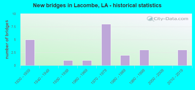
- New bridges - historical statistics
- 51930-1939
- 11950-1959
- 11960-1969
- 81970-1979
- 21980-1989
- 31990-1999
- 32010-2019
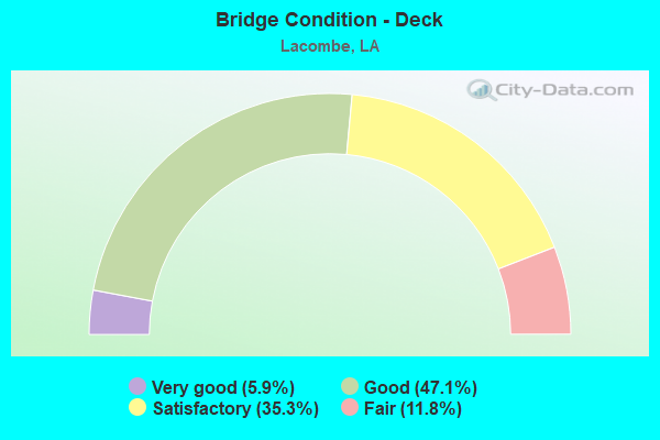
- Bridge Condition - Deck
- 5.9%Very good
- 47.1%Good
- 35.3%Satisfactory
- 11.8%Fair
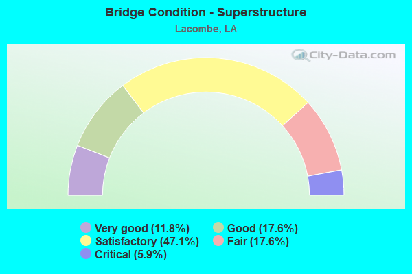
- Bridge Condition - Superstructure
- 11.8%Very good
- 17.6%Good
- 47.1%Satisfactory
- 17.6%Fair
- 5.9%Critical
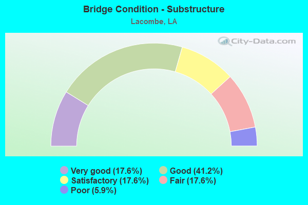
- Bridge Condition - Substructure
- 17.6%Very good
- 41.2%Good
- 17.6%Satisfactory
- 17.6%Fair
- 5.9%Poor
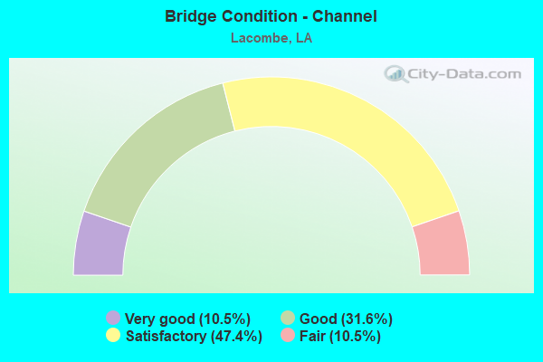
- Bridge Condition - Channel
- 10.5%Very good
- 31.6%Good
- 47.4%Satisfactory
- 10.5%Fair
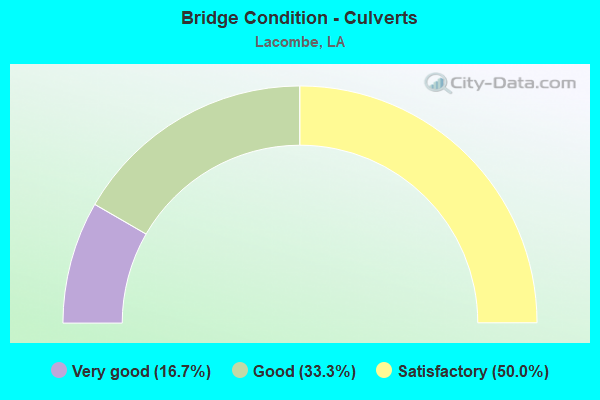
- Bridge Condition - Culverts
- 16.7%Very good
- 33.3%Good
- 50.0%Satisfactory
Find on map >> Show street view
Structure Number: 625200000107031, Location: 1.65 MILES SOUTH OF US90 (Lat: 30.294469, Lng: -89.918131), Route carried "on" structure: County highway , Year Built: 2015, Status: Open, Structure Length: 0.98m (3.22ft), Average Daily Traffic: 284 (year 2017), Average Future Daily Traffic: 312 (year 2037), Design Load: HS 20, Features Intersected: CYPRESS BAYOU, Facility Carried by Structure: Grand Ave
Minimum Vertical Clearance: 30+ m (98+ ft), Kilometerpoint: 0.000, Lanes on structure: 2, Owner: County Highway Agency, Approaching Roadway Width: 9.1m (29.9ft), Skew: 30 degrees, Material/Design: Concrete, Design/Construction: Culvert, Number Of Spans In Main Unit: 3, Length of Maximum Span: 2.7m (8.9ft), Curb-To-Curb Width: 9.4m (30.8ft), Out-to-Out Width: 17.0m (55.8ft)
Condition: Channel: Very good, Culverts: Very good, Operating Rating: 42.1 metric tons, Method Used To Determine Operating Rating: Load and Resistance Factor Rating (LRFR) rating reported by rating factor(RF) method using HL-93 loadings, Inventory Rating: 32.4 metric tons, Method Used To Determine Inventory Rating: Load and Resistance Factor Rating (LRFR) rating reported by rating factor(RF) method using HL-93 loadings, Structural Evaluation: Equal to present desirable criteria, Deck Geometry: Equal to present minimum criteria, Waterway Adequacy: Equal to present desirable criteria, Approach Roadway Alignment: Equal to present minimum criteria, Designated Inspection Frequency: Every 24 months, Inspection Date: December 2020, Deck Structure Type: Concrete Cast-file-Place
Find on map >> Show street view
Structure Number: 62520000010704, Location: 2.05 MILES SOUTH OF LA 43 (Lat: 30.286669, Lng: -89.954561), Route carried "on" structure: County highway , Year Built: 2010, Status: Open, Structure Length: 4.27m (14.01ft), Average Daily Traffic: 900 (year 2010), Average Future Daily Traffic: 684 (year 2036), Design Load: HS 20, Features Intersected: POWELL CANAL, Facility Carried by Structure: Lake Rd
Minimum Vertical Clearance: 30+ m (98+ ft), Kilometerpoint: 0.000, Lanes on structure: 2, Owner: County Highway Agency, Approaching Roadway Width: 7.6m (24.9ft), Material/Design: Concrete, Design/Construction: Stringer/Multi-beam, Number Of Spans In Main Unit: 1, Number Of Approach Spans: 4, Length of Maximum Span: 11.9m (39.0ft), Curb-To-Curb Width: 7.3m (24.0ft), Out-to-Out Width: 8.1m (26.6ft)
Condition: Deck: Very good, Superstructure: Very good, Substructure: Very good, Channel: Very good, Operating Rating: 32.4 metric tons, Method Used To Determine Operating Rating: Load and Resistance Factor Rating (LRFR) rating reported by rating factor(RF) method using HL-93 loadings, Inventory Rating: 24.9 metric tons, Method Used To Determine Inventory Rating: Load and Resistance Factor Rating (LRFR) rating reported by rating factor(RF) method using HL-93 loadings, Structural Evaluation: Equal to present minimum criteria, Deck Geometry: Meets minimum limits, Waterway Adequacy: Better than present minimum criteria, Approach Roadway Alignment: Better than present minimum criteria, Designated Inspection Frequency: Every 24 months, Inspection Date: January 2021, Deck Structure Type: Concrete Cast-file-Place
Find on map >> Show street view
Structure Number: 625200000620262, Location: JCT OF LA 1088 AND I 12 (Lat: 30.392350, Lng: -90.003600), Route carried "on" structure: State highway 1088, Year Built: 2011, Status: Open, Structure Length: 11.46m (37.60ft), Average Daily Traffic: 4,550 (year 2016), Truck Traffic: 8%, Average Future Daily Traffic: 6,916 (year 2036), Design Load: HS 20, Features Intersected: LA 1088 OVER I 12
Minimum Vertical Clearance: 5.05m (16.57ft), Kilometerpoint: 5.320, Lanes on structure: 2, Lanes under structure: 4, Owner: State Highway Agency, Approaching Roadway Width: 14.6m (47.9ft), Skew: 34 degrees, Material/Design: Prestressed concrete continuous, Design/Construction: Stringer/Multi-beam, Number Of Spans In Main Unit: 4, Length of Maximum Span: 34.4m (112.9ft), Curb or Sidewalk Widths: Left: 2.4m (7.9ft), Right: 1.2m (3.9ft), Curb-To-Curb Width: 11.0m (36.1ft), Out-to-Out Width: 11.7m (38.4ft)
Condition: Deck: Good, Superstructure: Very good, Substructure: Very good, Operating Rating: 49.6 metric tons, Method Used To Determine Operating Rating: Load and Resistance Factor Rating (LRFR) rating reported by rating factor(RF) method using HL-93 loadings, Inventory Rating: 35.0 metric tons, Method Used To Determine Inventory Rating: Load and Resistance Factor Rating (LRFR) rating reported by rating factor(RF) method using HL-93 loadings, Structural Evaluation: Equal to present desirable criteria, Deck Geometry: Equal to present minimum criteria, Underclear: Equal to present desirable criteria, Approach Roadway Alignment: Equal to present desirable criteria, Designated Inspection Frequency: Every 24 months, Inspection Date: August 2021, Deck Structure Type: Concrete Cast-file-Place, Wearing Surface/Protective System: Wearing Surface: Monolithic Concrete
Find on map >> Show street view
Structure Number: 625200131206411, Location: US0190 (Lat: 30.337611, Lng: -90.002900), Route carried "on" structure: US 190, Year Built: 1932, Status: Open, Structure Length: 3.69m (12.11ft), Average Daily Traffic: 9,200 (year 2016), Truck Traffic: 6%, Average Future Daily Traffic: 6,992 (year 2036), Design Load: H 15, Features Intersected: CANE BAYOU
Minimum Vertical Clearance: 30+ m (98+ ft), Kilometerpoint: 11.177, Lanes on structure: 2, Base Highway Network: Yes (Inventory Route: 13-12-1, Subroute: 10), Owner: State Highway Agency, Approaching Roadway Width: 13.4m (44.0ft), Material/Design: Concrete, Design/Construction: Tee Beam, Number Of Spans In Main Unit: 4, Length of Maximum Span: 9.1m (29.9ft), Curb-To-Curb Width: 7.3m (24.0ft), Out-to-Out Width: 8.3m (27.2ft)
Condition: Deck: Satisfactory, Superstructure: Satisfactory, Substructure: Satisfactory, Channel: Good, Operating Rating: 49.0 metric tons, Method Used To Determine Operating Rating: Load Factor (LF), Inventory Rating: 29.0 metric tons, Method Used To Determine Inventory Rating: Load Factor (LF), Structural Evaluation: Equal to present minimum criteria, Deck Geometry: High priority of replacement, Waterway Adequacy: Better than present minimum criteria, Approach Roadway Alignment: Better than present minimum criteria, Length Of Structure Improvement: 4.60m (15.09ft), Designated Inspection Frequency: Every 24 months, Inspection Date: September 2021, Bridge Improvement Cost: $392,000, Total Project Cost: $588,000 ( Estimate for 2016), Deck Structure Type: Concrete Cast-file-Place, Wearing Surface/Protective System: Wearing Surface: Bituminous
Find on map >> Show street view
Structure Number: 625200131210841, Location: 0.12 MI NE OF LA 434 (Lat: 30.313511, Lng: -89.935900), Route carried "on" structure: US 190, Year Built: 1938, Status: Open, Structure Length: 9.75m (31.99ft), Average Daily Traffic: 10,400 (year 2016), Truck Traffic: 6%, Average Future Daily Traffic: 7,904 (year 2036), Design Load: H 15, Features Intersected: BAYOU LACOMBE
Minimum Vertical Clearance: 30+ m (98+ ft), Kilometerpoint: 18.314, Lanes on structure: 2, Base Highway Network: Yes (Inventory Route: 13-12-1, Subroute: 10), Owner: State Highway Agency, Approaching Roadway Width: 13.4m (44.0ft), Material/Design: Steel, Design/Construction: Movable - Swing, Number Of Spans In Main Unit: 1, Number Of Approach Spans: 5, Length of Maximum Span: 39.6m (129.9ft), Curb or Sidewalk Widths: Left: 0.9m (3.0ft), Right: 0.9m (3.0ft), Curb-To-Curb Width: 7.5m (24.6ft), Out-to-Out Width: 10.0m (32.8ft)
Condition: Deck: Satisfactory, Superstructure: Satisfactory, Substructure: Satisfactory, Channel: Good, Operating Rating: 40.8 metric tons, Method Used To Determine Operating Rating: Allowable Stress (AS), Inventory Rating: 15.4 metric tons, Method Used To Determine Inventory Rating: Allowable Stress (AS), Structural Evaluation: High priority of replacement, Deck Geometry: High priority of replacement, Waterway Adequacy: Better than present minimum criteria, Approach Roadway Alignment: Equal to present minimum criteria, Length Of Structure Improvement: 10.67m (35.01ft), Designated Inspection Frequency: Every 24 months, Critical Feature Inspection Frequency: Every 24 months, Underwater Inspection Frequency: Every 60 months, Inspection Date: September 2021, Critical Feature Inspection Date: September 2021, Underwater Inspection Date: October 2019, Bridge Improvement Cost: $910,000, Total Project Cost: $1,365,000 ( Estimate for 2016), Deck Structure Type: Concrete Cast-file-Place
Find on map >> Show street view
Structure Number: 625200131211661, Location: US0190 (Lat: 30.315869, Lng: -89.925500), Route carried "on" structure: US 190, Year Built: 1932, Status: Open, Structure Length: 3.69m (12.11ft), Average Daily Traffic: 10,400 (year 2016), Truck Traffic: 6%, Average Future Daily Traffic: 7,904 (year 2036), Design Load: H 15, Features Intersected: BIG BRANCH
Minimum Vertical Clearance: 30+ m (98+ ft), Kilometerpoint: 19.539, Lanes on structure: 2, Base Highway Network: Yes (Inventory Route: 13-12-1, Subroute: 10), Owner: State Highway Agency, Approaching Roadway Width: 13.4m (44.0ft), Material/Design: Concrete, Design/Construction: Tee Beam, Number Of Spans In Main Unit: 4, Length of Maximum Span: 9.1m (29.9ft), Curb-To-Curb Width: 7.3m (24.0ft), Out-to-Out Width: 8.3m (27.2ft)
Condition: Deck: Good, Superstructure: Satisfactory, Substructure: Satisfactory, Channel: Good, Operating Rating: 48.1 metric tons, Method Used To Determine Operating Rating: Load Factor (LF), Inventory Rating: 28.1 metric tons, Method Used To Determine Inventory Rating: Load Factor (LF), Structural Evaluation: Equal to present minimum criteria, Deck Geometry: High priority of replacement, Waterway Adequacy: Better than present minimum criteria, Approach Roadway Alignment: Equal to present desirable criteria, Length Of Structure Improvement: 4.60m (15.09ft), Designated Inspection Frequency: Every 24 months, Underwater Inspection Frequency: Every 60 months, Inspection Date: September 2021, Underwater Inspection Date: October 2019, Bridge Improvement Cost: $392,000, Total Project Cost: $588,000 ( Estimate for 2016), Deck Structure Type: Concrete Cast-file-Place, Wearing Surface/Protective System: Wearing Surface: Bituminous
Find on map >> Show street view
Structure Number: 625200131213091, Location: 1.8 M E OF LA 434 (Lat: 30.309761, Lng: -89.903400), Route carried "on" structure: US 190, Year Built: 1933, Status: Open, Structure Length: 0.88m (2.89ft), Average Daily Traffic: 10,400 (year 2016), Truck Traffic: 6%, Average Future Daily Traffic: 7,904 (year 2036), Design Load: H 15, Features Intersected: LITTLE BAYOU
Minimum Vertical Clearance: 30+ m (98+ ft), Kilometerpoint: 21.771, Lanes on structure: 2, Base Highway Network: Yes (Inventory Route: 13-12-1, Subroute: 10), Owner: State Highway Agency, Approaching Roadway Width: 13.4m (44.0ft), Material/Design: Concrete, Design/Construction: Culvert, Number Of Spans In Main Unit: 5, Length of Maximum Span: 2.4m (7.9ft), Curb-To-Curb Width: 7.3m (24.0ft), Out-to-Out Width: 15.9m (52.2ft)
Condition: Channel: Satisfactory, Culverts: Satisfactory, Operating Rating: 42.1 metric tons, Method Used To Determine Operating Rating: Load and Resistance Factor Rating (LRFR) rating reported by rating factor(RF) method using HL-93 loadings, Inventory Rating: 32.4 metric tons, Method Used To Determine Inventory Rating: Load and Resistance Factor Rating (LRFR) rating reported by rating factor(RF) method using HL-93 loadings, Structural Evaluation: Equal to present minimum criteria, Deck Geometry: High priority of replacement, Waterway Adequacy: Equal to present minimum criteria, Approach Roadway Alignment: Equal to present desirable criteria, Designated Inspection Frequency: Every 24 months, Inspection Date: September 2021, Deck Structure Type: Concrete Cast-file-Place
Find on map >> Show street view
Structure Number: 625200131213841, Location: 2.5 M E OF LA 434 (Lat: 30.308200, Lng: -89.890300), Route carried "on" structure: US 190, Year Built: 1933, Status: Open, Structure Length: 0.85m (2.79ft), Average Daily Traffic: 10,400 (year 2016), Truck Traffic: 6%, Average Future Daily Traffic: 7,904 (year 2036), Design Load: H 15, Features Intersected: CREEK
Minimum Vertical Clearance: 30+ m (98+ ft), Kilometerpoint: 23.047, Lanes on structure: 2, Base Highway Network: Yes (Inventory Route: 13-12-1, Subroute: 10), Owner: State Highway Agency, Approaching Roadway Width: 13.4m (44.0ft), Material/Design: Concrete, Design/Construction: Culvert, Number Of Spans In Main Unit: 7, Length of Maximum Span: 0.9m (3.0ft), Curb-To-Curb Width: 7.3m (24.0ft), Out-to-Out Width: 14.6m (47.9ft)
Condition: Channel: Good, Culverts: Satisfactory, Operating Rating: 28.5 metric tons, Method Used To Determine Operating Rating: Load and Resistance Factor Rating (LRFR) rating reported by rating factor(RF) method using HL-93 loadings, Inventory Rating: 22.0 metric tons, Method Used To Determine Inventory Rating: Load and Resistance Factor Rating (LRFR) rating reported by rating factor(RF) method using HL-93 loadings, Structural Evaluation: Somewhat better than minimum adequacy, Deck Geometry: High priority of replacement, Waterway Adequacy: Better than present minimum criteria, Approach Roadway Alignment: Equal to present desirable criteria, Length Of Structure Improvement: 1.46m (4.79ft), Designated Inspection Frequency: Every 24 months, Inspection Date: September 2021, Bridge Improvement Cost: $124,000, Total Project Cost: $186,000 ( Estimate for 2016), Deck Structure Type: Concrete Cast-file-Place
Find on map >> Show street view
Structure Number: 625204540420071, Location: 1.0 M W OF LA 434 (Lat: 30.361031, Lng: -89.938000), Route carried "on" structure: County highway , Year Built: 1976, Status: Open, Structure Length: 8.50m (27.89ft), Average Daily Traffic: 4,410 (year 2015), Average Future Daily Traffic: 3,351 (year 2036), Design Load: HS 20, Features Intersected: I-12, Facility Carried by Structure: FISH HATCHERY RD.
Minimum Vertical Clearance: 30+ m (98+ ft), Kilometerpoint: 32.489, Lanes on structure: 2, Lanes under structure: 4, Base Highway Network: Yes (Inventory Route: 454-04-1, Subroute: 10), Owner: State Highway Agency, Approaching Roadway Width: 11.0m (36.1ft), Skew: 1 degrees, Material/Design: Prestressed concrete, Design/Construction: Stringer/Multi-beam, Number Of Spans In Main Unit: 4, Length of Maximum Span: 28.0m (91.9ft), Curb-To-Curb Width: 7.9m (25.9ft), Out-to-Out Width: 9.1m (29.9ft)
Condition: Deck: Good, Superstructure: Satisfactory, Substructure: Good, Operating Rating: 61.7 metric tons, Method Used To Determine Operating Rating: Load Factor (LF), Inventory Rating: 33.6 metric tons, Method Used To Determine Inventory Rating: Load Factor (LF), Structural Evaluation: Equal to present minimum criteria, Deck Geometry: High priority of corrective action, Underclear: Somewhat better than minimum adequacy, Approach Roadway Alignment: Equal to present desirable criteria, Length Of Structure Improvement: 9.42m (30.91ft), Designated Inspection Frequency: Every 24 months, Inspection Date: August 2021, Bridge Improvement Cost: $803,000, Total Project Cost: $1,204,000 ( Estimate for 2016), Deck Structure Type: Concrete Cast-file-Place
Find on map >> Show street view
Structure Number: 625204540420621, Location: 0.3 M W OF LA 434 (Lat: 30.357139, Lng: -89.930100), Route carried "on" structure: Interstate 12, Year Built: 1976, Status: Open, Structure Length: 8.53m (27.99ft), Average Daily Traffic: 22,100 (year 2016), Truck Traffic: 26%, Average Future Daily Traffic: 20,109 (year 2036), Design Load: HS 20, Features Intersected: BAYOU LACOMBE
Minimum Vertical Clearance: 30+ m (98+ ft), Kilometerpoint: 33.381, Lanes on structure: 2, Base Highway Network: Yes (Inventory Route: 454-04-1, Subroute: 10), Owner: State Highway Agency, Approaching Roadway Width: 11.6m (38.1ft), Skew: 13 degrees, Material/Design: Prestressed concrete, Design/Construction: Stringer/Multi-beam, Number Of Spans In Main Unit: 4, Length of Maximum Span: 21.3m (69.9ft), Curb-To-Curb Width: 12.2m (40.0ft), Out-to-Out Width: 13.0m (42.7ft)
Condition: Deck: Good, Superstructure: Good, Substructure: Good, Channel: Satisfactory, Operating Rating: 89.8 metric tons, Method Used To Determine Operating Rating: Load Factor (LF), Inventory Rating: 38.1 metric tons, Method Used To Determine Inventory Rating: Load Factor (LF), Structural Evaluation: Better than present minimum criteria, Deck Geometry: Better than present minimum criteria, Waterway Adequacy: Equal to present desirable criteria, Approach Roadway Alignment: Equal to present desirable criteria, Designated Inspection Frequency: Every 24 months, Inspection Date: August 2021, Deck Structure Type: Concrete Cast-file-Place
Find on map >> Show street view
Structure Number: 625204540420622, Location: 0.3 M W OF LA 434 (Lat: 30.357039, Lng: -89.929300), Route carried "on" structure: Interstate 12, Year Built: 1976, Status: Open, Structure Length: 8.53m (27.99ft), Average Daily Traffic: 22,100 (year 2016), Truck Traffic: 26%, Average Future Daily Traffic: 20,109 (year 2036), Design Load: HS 20, Features Intersected: BAYOU LACOMBE
Minimum Vertical Clearance: 30+ m (98+ ft), Kilometerpoint: 20.453, Lanes on structure: 2, Base Highway Network: Yes (Inventory Route: 454-04-2, Subroute: 10), Owner: State Highway Agency, Approaching Roadway Width: 11.6m (38.1ft), Skew: 13 degrees, Material/Design: Prestressed concrete, Design/Construction: Stringer/Multi-beam, Number Of Spans In Main Unit: 4, Length of Maximum Span: 21.3m (69.9ft), Curb-To-Curb Width: 12.2m (40.0ft), Out-to-Out Width: 13.0m (42.7ft)
Condition: Deck: Good, Superstructure: Good, Substructure: Good, Channel: Satisfactory, Operating Rating: 89.8 metric tons, Method Used To Determine Operating Rating: Load Factor (LF), Inventory Rating: 38.1 metric tons, Method Used To Determine Inventory Rating: Load Factor (LF), Structural Evaluation: Better than present minimum criteria, Deck Geometry: Better than present minimum criteria, Waterway Adequacy: Better than present minimum criteria, Approach Roadway Alignment: Equal to present desirable criteria, Designated Inspection Frequency: Every 24 months, Inspection Date: August 2021, Deck Structure Type: Concrete Cast-file-Place
Find on map >> Show street view
Structure Number: 625204540423051, Location: I0012 (Lat: 30.338961, Lng: -89.895600), Route carried "on" structure: Interstate 12, Year Built: 1972, Status: Open, Structure Length: 0.67m (2.20ft), Average Daily Traffic: 44,400 (year 2016), Truck Traffic: 26%, Average Future Daily Traffic: 33,820 (year 2036), Design Load: HS 20, Features Intersected: BIG BRANCH
Minimum Vertical Clearance: 30+ m (98+ ft), Kilometerpoint: 37.264, Lanes on structure: 4, Base Highway Network: Yes (Inventory Route: 454-04-1, Subroute: 10), Owner: State Highway Agency, Approaching Roadway Width: 12.2m (40.0ft), Skew: 16 degrees, Material/Design: Concrete, Design/Construction: Culvert, Number Of Spans In Main Unit: 2, Length of Maximum Span: 3.0m (9.8ft), Curb-To-Curb Width: 23.8m (78.1ft), Out-to-Out Width: 82.3m (270.0ft)
Condition: Channel: Satisfactory, Culverts: Good, Operating Rating: 42.1 metric tons, Method Used To Determine Operating Rating: Load and Resistance Factor Rating (LRFR) rating reported by rating factor(RF) method using HL-93 loadings, Inventory Rating: 32.4 metric tons, Method Used To Determine Inventory Rating: Load and Resistance Factor Rating (LRFR) rating reported by rating factor(RF) method using HL-93 loadings, Structural Evaluation: Better than present minimum criteria, Deck Geometry: Superior to present desirable criteria, Waterway Adequacy: Better than present minimum criteria, Approach Roadway Alignment: Equal to present desirable criteria, Designated Inspection Frequency: Every 24 months, Inspection Date: August 2021, Deck Structure Type: Concrete Cast-file-Place
Find on map >> Show street view
Structure Number: 625204540425531, Location: 4.2 M E OF LA 434 (Lat: 30.323919, Lng: -89.857200), Route carried "on" structure: County highway , Year Built: 1972, Status: Closed, Structure Length: 9.81m (32.19ft), Average Daily Traffic: 4,450 (year 2015), Average Future Daily Traffic: 3,382 (year 2036), Design Load: HS 20, Features Intersected: I-12, Facility Carried by Structure: DIXIE RANCH RD.
Minimum Vertical Clearance: 30+ m (98+ ft), Kilometerpoint: 41.294, Lanes on structure: 2, Lanes under structure: 4, Base Highway Network: Yes (Inventory Route: 454-04-1, Subroute: 10), Owner: State Highway Agency, Approaching Roadway Width: 20.1m (65.9ft), Material/Design: Steel, Design/Construction: Stringer/Multi-beam, Number Of Spans In Main Unit: 4, Length of Maximum Span: 32.6m (107.0ft), Curb-To-Curb Width: 7.9m (25.9ft), Out-to-Out Width: 8.8m (28.9ft)
Condition: Deck: Satisfactory, Superstructure: Critical, Substructure: Good, Deck Geometry: High priority of corrective action, Underclear: Somewhat better than minimum adequacy, Bridge Posting: Required (Relationship of Operating Rating to Maximum Legal Load: > 39.9% below), Length Of Structure Improvement: 10.73m (35.20ft), Designated Inspection Frequency: Every 24 months, Other Special Inspection Frequency: Every 6 months, Inspection Date: Febuary 2020, Other Special Inspection Date: August 2021, Bridge Improvement Cost: $915,000, Total Project Cost: $1,372,000 ( Estimate for 2016), Deck Structure Type: Concrete Cast-file-Place
Find on map >> Show street view
Structure Number: 625208521103301, Location: 2.5 M E OF LA 59 (Lat: 30.392381, Lng: -90.003500), Route carried "on" structure: State highway 1088, Year Built: 1976, Status: Open, Structure Length: 10.61m (34.81ft), Average Daily Traffic: 9,100 (year 2016), Truck Traffic: 8%, Average Future Daily Traffic: 6,916 (year 2036), Design Load: HS 20, Features Intersected: I-12
Minimum Vertical Clearance: 30+ m (98+ ft), Kilometerpoint: 5.329, Lanes on structure: 2, Lanes under structure: 4, Owner: State Highway Agency, Approaching Roadway Width: 9.1m (29.9ft), Skew: 3 degrees, Material/Design: Steel continuous, Design/Construction: Stringer/Multi-beam, Number Of Spans In Main Unit: 4, Length of Maximum Span: 34.4m (112.9ft), Curb-To-Curb Width: 7.9m (25.9ft), Out-to-Out Width: 9.1m (29.9ft)
Condition: Deck: Good, Superstructure: Satisfactory, Substructure: Good, Channel: Good, Operating Rating: 59.9 metric tons, Method Used To Determine Operating Rating: Load Factor (LF), Inventory Rating: 35.4 metric tons, Method Used To Determine Inventory Rating: Load Factor (LF), Structural Evaluation: Equal to present minimum criteria, Deck Geometry: High priority of corrective action, Underclear: Somewhat better than minimum adequacy, Approach Roadway Alignment: Equal to present desirable criteria, Length Of Structure Improvement: 11.52m (37.80ft), Designated Inspection Frequency: Every 24 months, Inspection Date: August 2021, Bridge Improvement Cost: $982,000, Total Project Cost: $1,473,000 ( Estimate for 2016), Deck Structure Type: Concrete Cast-file-Place
Find on map >> Show street view
Structure Number: 625208521105251, Location: 1.7 M E OF I-12 (Lat: 30.402250, Lng: -89.973200), Route carried "on" structure: State highway 1088, Year Built: 1974, Status: Open, Structure Length: 0.79m (2.59ft), Average Daily Traffic: 9,100 (year 2016), Truck Traffic: 12%, Average Future Daily Traffic: 6,916 (year 2036), Design Load: HS 20, Features Intersected: CANE BAYOU
Minimum Vertical Clearance: 30+ m (98+ ft), Kilometerpoint: 8.459, Lanes on structure: 2, Owner: State Highway Agency, Approaching Roadway Width: 6.4m (21.0ft), Material/Design: Steel, Design/Construction: Culvert, Number Of Spans In Main Unit: 5, Length of Maximum Span: 1.2m (3.9ft), Curb-To-Curb Width: 6.4m (21.0ft), Out-to-Out Width: 17.7m (58.1ft)
Condition: Channel: Satisfactory, Culverts: Satisfactory, Operating Rating: 59.9 metric tons, Method Used To Determine Operating Rating: Load and Resistance Factor Rating (LRFR) rating reported by rating factor(RF) method using HL-93 loadings, Inventory Rating: 46.0 metric tons, Method Used To Determine Inventory Rating: Load and Resistance Factor Rating (LRFR) rating reported by rating factor(RF) method using HL-93 loadings, Structural Evaluation: Equal to present minimum criteria, Deck Geometry: High priority of replacement, Waterway Adequacy: Better than present minimum criteria, Approach Roadway Alignment: Equal to present desirable criteria, Length Of Structure Improvement: 1.40m (4.59ft), Designated Inspection Frequency: Every 24 months, Inspection Date: October 2021, Bridge Improvement Cost: $119,000, Total Project Cost: $178,000 ( Estimate for 2016)
Find on map >> Show street view
Structure Number: 625208521202691, Location: LA0434 (Lat: 30.352011, Lng: -89.920800), Route carried "on" structure: State highway 434, Year Built: 1973, Status: Open, Structure Length: 8.08m (26.51ft), Average Daily Traffic: 3,800 (year 2016), Truck Traffic: 6%, Average Future Daily Traffic: 2,888 (year 2036), Design Load: HS 20, Features Intersected: LA 434 OVER I-12
Minimum Vertical Clearance: 30+ m (98+ ft), Kilometerpoint: 4.223, Lanes on structure: 2, Lanes under structure: 4, Base Highway Network: Yes (Inventory Route: 852-12-1, Subroute: 10), Owner: State Highway Agency, Approaching Roadway Width: 12.2m (40.0ft), Material/Design: Prestressed concrete, Design/Construction: Stringer/Multi-beam, Number Of Spans In Main Unit: 4, Length of Maximum Span: 26.8m (87.9ft), Curb-To-Curb Width: 12.2m (40.0ft), Out-to-Out Width: 13.2m (43.3ft)
Condition: Deck: Good, Superstructure: Satisfactory, Substructure: Very good, Operating Rating: 88.9 metric tons, Method Used To Determine Operating Rating: Load Factor (LF), Inventory Rating: 48.1 metric tons, Method Used To Determine Inventory Rating: Load Factor (LF), Structural Evaluation: Equal to present minimum criteria, Deck Geometry: Equal to present minimum criteria, Underclear: Somewhat better than minimum adequacy, Approach Roadway Alignment: Equal to present desirable criteria, Designated Inspection Frequency: Every 24 months, Inspection Date: August 2021, Deck Structure Type: Concrete Cast-file-Place
Find on map >> Show street view
Structure Number: 625208521205991, Location: 2.2 M S OF LA 36 (Lat: 30.393261, Lng: -89.895000), Route carried "on" structure: State highway 434, Year Built: 1953, Status: Posted for load, Structure Length: 2.96m (9.71ft), Average Daily Traffic: 3,800 (year 2016), Truck Traffic: 12%, Average Future Daily Traffic: 2,888 (year 2036), Design Load: H 15, Features Intersected: BAYOU LACOMBE
Minimum Vertical Clearance: 30+ m (98+ ft), Kilometerpoint: 9.485, Lanes on structure: 2, Owner: State Highway Agency, Approaching Roadway Width: 9.8m (32.2ft), Material/Design: Wood or Timber, Design/Construction: Stringer/Multi-beam, Number Of Spans In Main Unit: 5, Length of Maximum Span: 5.8m (19.0ft), Curb-To-Curb Width: 7.6m (24.9ft), Out-to-Out Width: 8.2m (26.9ft)
Condition: Deck: Satisfactory, Superstructure: Fair, Substructure: Poor, Channel: Good, Operating Rating: 20.0 metric tons, Method Used To Determine Operating Rating: Allowable Stress (AS), Inventory Rating: 14.5 metric tons, Method Used To Determine Inventory Rating: Allowable Stress (AS), Structural Evaluation: Meets minimum limits, Deck Geometry: High priority of replacement, Waterway Adequacy: Better than present minimum criteria, Approach Roadway Alignment: Equal to present desirable criteria, Bridge Posting: Required (Relationship of Operating Rating to Maximum Legal Load: 10.0 - 19.9% below), Length Of Structure Improvement: 3.78m (12.40ft), Designated Inspection Frequency: Every 24 months, Other Special Inspection Frequency: Every 12 months, Inspection Date: April 2020, Other Special Inspection Date: April 2021, Bridge Improvement Cost: $322,000, Total Project Cost: $483,000 ( Estimate for 2016), Deck Structure Type: Wood or Timber, Wearing Surface/Protective System: Wearing Surface: Bituminous
Find on map >> Show street view
Structure Number: 625230160895741, Location: 1080M SOUTH OF LA 434 (Lat: 30.268111, Lng: -89.956389), Route carried "on" structure: County highway , Year Built: 1992, Status: Posted for load, Structure Length: 1.22m (4.00ft), Average Daily Traffic: 100 (year 1992), Average Future Daily Traffic: 76 (year 2036), Design Load: HS 20, Features Intersected: LACOMBE BAYOU, Facility Carried by Structure: Lake Rd
Minimum Vertical Clearance: 30+ m (98+ ft), Kilometerpoint: 0.000, Lanes on structure: 1, Owner: County Highway Agency, Approaching Roadway Width: 6.4m (21.0ft), Material/Design: Concrete, Design/Construction: Slab, Number Of Spans In Main Unit: 2, Length of Maximum Span: 5.8m (19.0ft), Curb-To-Curb Width: 4.9m (16.1ft), Out-to-Out Width: 5.7m (18.7ft)
Condition: Deck: Fair, Superstructure: Fair, Substructure: Fair, Channel: Satisfactory, Operating Rating: 23.3 metric tons, Method Used To Determine Operating Rating: Load and Resistance Factor Rating (LRFR) rating reported by rating factor(RF) method using HL-93 loadings, Inventory Rating: 18.1 metric tons, Method Used To Determine Inventory Rating: Load and Resistance Factor Rating (LRFR) rating reported by rating factor(RF) method using HL-93 loadings, Structural Evaluation: Somewhat better than minimum adequacy, Deck Geometry: High priority of corrective action, Waterway Adequacy: Somewhat better than minimum adequacy, Approach Roadway Alignment: Equal to present minimum criteria, Bridge Posting: Required (Relationship of Operating Rating to Maximum Legal Load: 10.0 - 19.9% below), Length Of Structure Improvement: 1.89m (6.20ft), Designated Inspection Frequency: Every 24 months, Underwater Inspection Frequency: Every 60 months, Inspection Date: November 2020, Underwater Inspection Date: September 2019, Bridge Improvement Cost: $112,000, Total Project Cost: $168,000 ( Estimate for 2016), Deck Structure Type: Concrete Precast Panels
Find on map >> Show street view
Structure Number: 625230167895731, Location: 1.0M SOUTH OF LA 434 (Lat: 30.279031, Lng: -89.954211), Route carried "on" structure: County highway , Year Built: 1992, Status: Open, Structure Length: 1.22m (4.00ft), Average Daily Traffic: 100 (year 1992), Average Future Daily Traffic: 76 (year 2036), Design Load: HS 20, Features Intersected: LACOMBE BAYOU, Facility Carried by Structure: Lake Rd
Minimum Vertical Clearance: 30+ m (98+ ft), Kilometerpoint: 0.000, Lanes on structure: 1, Owner: County Highway Agency, Approaching Roadway Width: 6.4m (21.0ft), Material/Design: Concrete, Design/Construction: Slab, Number Of Spans In Main Unit: 2, Length of Maximum Span: 5.8m (19.0ft), Curb-To-Curb Width: 4.9m (16.1ft), Out-to-Out Width: 5.7m (18.7ft)
Condition: Deck: Fair, Superstructure: Fair, Substructure: Fair, Channel: Satisfactory, Operating Rating: 29.5 metric tons, Method Used To Determine Operating Rating: Load and Resistance Factor Rating (LRFR) rating reported by rating factor(RF) method using HL-93 loadings, Inventory Rating: 22.7 metric tons, Method Used To Determine Inventory Rating: Load and Resistance Factor Rating (LRFR) rating reported by rating factor(RF) method using HL-93 loadings, Structural Evaluation: Somewhat better than minimum adequacy, Deck Geometry: High priority of corrective action, Waterway Adequacy: Equal to present minimum criteria, Approach Roadway Alignment: Equal to present minimum criteria, Length Of Structure Improvement: 1.89m (6.20ft), Designated Inspection Frequency: Every 24 months, Inspection Date: November 2020, Bridge Improvement Cost: $112,000, Total Project Cost: $168,000 ( Estimate for 2016), Deck Structure Type: Concrete Precast Panels
Find on map >> Show street view
Structure Number: 625230189895331, Location: US190 3.2 MI E LA 434 (Lat: 30.318689, Lng: -89.887461), Route carried "on" structure: County highway , Year Built: 1995, Status: Open, Structure Length: 0.64m (2.10ft), Average Daily Traffic: 100 (year 2016), Average Future Daily Traffic: 76 (year 2036), Design Load: HS 20, Features Intersected: LITTLE BAYOU PIPE, Facility Carried by Structure: Shannon Dr
Minimum Vertical Clearance: 30+ m (98+ ft), Kilometerpoint: 0.000, Lanes on structure: 2, Base Highway Network: Yes, Owner: County Highway Agency, Approaching Roadway Width: 6.1m (20.0ft), Material/Design: Steel, Design/Construction: Culvert, Length of Maximum Span: 2.7m (8.9ft)
Condition: Channel: Satisfactory, Culverts: Good, Operating Rating: 21.1 metric tons, Method Used To Determine Operating Rating: Load and Resistance Factor Rating (LRFR) rating reported by rating factor(RF) method using HL-93 loadings, Inventory Rating: 16.2 metric tons, Method Used To Determine Inventory Rating: Load and Resistance Factor Rating (LRFR) rating reported by rating factor(RF) method using HL-93 loadings, Structural Evaluation: Somewhat better than minimum adequacy, Waterway Adequacy: Better than present minimum criteria, Approach Roadway Alignment: Better than present minimum criteria, Designated Inspection Frequency: Every 24 months, Inspection Date: January 2021, Deck Structure Type: Other
Find on map >> Show street view
Structure Number: 625230194895511, Location: 0.90 MI E. OF LA 434 (Lat: 30.323039, Lng: -89.921569), Route carried "on" structure: County highway , Year Built: 1984, Status: Open, Structure Length: 1.74m (5.71ft), Average Daily Traffic: 80 (year 2016), Average Future Daily Traffic: 60 (year 2036), Design Load: HS 20, Features Intersected: BRIDGE OVER CREEK, Facility Carried by Structure: Berry Todd Rd
Minimum Vertical Clearance: 30+ m (98+ ft), Kilometerpoint: 0.000, Lanes on structure: 2, Owner: County Highway Agency, Approaching Roadway Width: 6.7m (22.0ft), Skew: 9 degrees, Material/Design: Concrete, Design/Construction: Slab, Number Of Spans In Main Unit: 3, Length of Maximum Span: 5.8m (19.0ft), Curb-To-Curb Width: 7.3m (24.0ft), Out-to-Out Width: 8.2m (26.9ft)
Condition: Deck: Good, Superstructure: Good, Substructure: Good, Channel: Satisfactory, Operating Rating: 24.0 metric tons, Method Used To Determine Operating Rating: Load and Resistance Factor Rating (LRFR) rating reported by rating factor(RF) method using HL-93 loadings, Inventory Rating: 18.5 metric tons, Method Used To Determine Inventory Rating: Load and Resistance Factor Rating (LRFR) rating reported by rating factor(RF) method using HL-93 loadings, Structural Evaluation: Somewhat better than minimum adequacy, Deck Geometry: Equal to present minimum criteria, Waterway Adequacy: Better than present minimum criteria, Approach Roadway Alignment: Better than present minimum criteria, Designated Inspection Frequency: Every 24 months, Inspection Date: January 2021, Deck Structure Type: Concrete Cast-file-Place
Find on map >> Show street view
Structure Number: 625230199895671, Location: 0.65 N.OF LA.1093-1 (Lat: 30.331250, Lng: -89.945669), Route carried "on" structure: County highway , Year Built: 1960, Status: Open, Structure Length: 2.38m (7.81ft), Average Daily Traffic: 280 (year 1974), Average Future Daily Traffic: 212 (year 2036), Design Load: HS 20, Features Intersected: CREEK, Facility Carried by Structure: Fish Hatchery Rd
Minimum Vertical Clearance: 30+ m (98+ ft), Kilometerpoint: 0.000, Lanes on structure: 2, Owner: County Highway Agency, Approaching Roadway Width: 6.4m (21.0ft), Material/Design: Concrete, Design/Construction: Slab, Number Of Spans In Main Unit: 4, Length of Maximum Span: 5.8m (19.0ft), Curb-To-Curb Width: 8.6m (28.2ft), Out-to-Out Width: 9.4m (30.8ft)
Condition: Deck: Satisfactory, Superstructure: Satisfactory, Substructure: Fair, Channel: Fair, Operating Rating: 38.9 metric tons, Method Used To Determine Operating Rating: Load and Resistance Factor Rating (LRFR) rating reported by rating factor(RF) method using HL-93 loadings, Inventory Rating: 30.1 metric tons, Method Used To Determine Inventory Rating: Load and Resistance Factor Rating (LRFR) rating reported by rating factor(RF) method using HL-93 loadings, Structural Evaluation: Somewhat better than minimum adequacy, Deck Geometry: Equal to present minimum criteria, Waterway Adequacy: Equal to present minimum criteria, Approach Roadway Alignment: Equal to present desirable criteria, Designated Inspection Frequency: Every 24 months, Inspection Date: Febuary 2021, Deck Structure Type: Concrete Precast Panels
Find on map >> Show street view
Structure Number: 625230220895541, Location: 0.7 MI N. OF LA 434 (Lat: 30.364931, Lng: -89.922450), Route carried "on" structure: County highway , Year Built: 1984, Status: Open, Structure Length: 2.90m (9.51ft), Average Daily Traffic: 100 (year 1980), Average Future Daily Traffic: 76 (year 2036), Design Load: HS 20, Features Intersected: BRIDGE OVER LACOMBE BAYO, Facility Carried by Structure: Krentel Rd
Minimum Vertical Clearance: 30+ m (98+ ft), Kilometerpoint: 0.000, Lanes on structure: 2, Owner: County Highway Agency, Approaching Roadway Width: 6.7m (22.0ft), Skew: 9 degrees, Material/Design: Concrete, Design/Construction: Slab, Number Of Spans In Main Unit: 5, Length of Maximum Span: 5.8m (19.0ft), Curb-To-Curb Width: 7.3m (24.0ft), Out-to-Out Width: 8.2m (26.9ft)
Condition: Deck: Satisfactory, Superstructure: Satisfactory, Substructure: Good, Channel: Fair, Operating Rating: 24.0 metric tons, Method Used To Determine Operating Rating: Load and Resistance Factor Rating (LRFR) rating reported by rating factor(RF) method using HL-93 loadings, Inventory Rating: 18.5 metric tons, Method Used To Determine Inventory Rating: Load and Resistance Factor Rating (LRFR) rating reported by rating factor(RF) method using HL-93 loadings, Structural Evaluation: Somewhat better than minimum adequacy, Deck Geometry: Equal to present minimum criteria, Waterway Adequacy: Better than present minimum criteria, Approach Roadway Alignment: Better than present minimum criteria, Designated Inspection Frequency: Every 24 months, Inspection Date: January 2021, Deck Structure Type: Concrete Cast-file-Place
Find on map >> Show street view
Structure Number: 625200000620262, Location: Jct. of LA 1088 & I-12 (Lat: 30.392669, Lng: -90.003461), Route carried "under" structure: Interstate 12, Structure Length: 0. m, Average Daily Traffic: 4,550 (year 2016), Truck Traffic: 8%, Features Intersected: LA 1088 over I-12
Minimum Vertical Clearance: 5.05m (16.57ft), Kilometerpoint: 25.291, Lanes on structure: 2, Lanes under structure: 4, Length of Maximum Span: 0.0m
Find on map >> Show street view
Structure Number: 625200000620262, Location: Jct. of LA 1088 & I12 (Lat: 30.392611, Lng: -90.002731), Route carried "under" structure: Interstate 12, Structure Length: 0. m, Average Daily Traffic: 4,550 (year 2016), Truck Traffic: 8%, Features Intersected: I-12
Minimum Vertical Clearance: 5.05m (16.57ft), Kilometerpoint: 28.548, Lanes on structure: 2, Lanes under structure: 4, Length of Maximum Span: 0.0m
Find on map >> Show street view
Structure Number: 625204540420071, Location: 1.2 MI W of LA 434 (Lat: 30.361519, Lng: -89.937819), Route carried "under" structure: Interstate 12, Structure Length: 0. m, Average Daily Traffic: 44,100 (year 2016), Features Intersected: I-12 WB under Fish Hatch
Minimum Vertical Clearance: 5.00m (16.40ft), Kilometerpoint: 21.412, Lanes on structure: 2, Length of Maximum Span: 0.0m
Find on map >> Show street view
Structure Number: 625204540420071, Location: 1.2 MI W of LA 434 (Lat: 30.361311, Lng: -89.937969), Route carried "under" structure: Interstate 12, Structure Length: 0. m, Average Daily Traffic: 44,100 (year 2016), Features Intersected: I-12 EB under FIsh Hatch
Minimum Vertical Clearance: 5.00m (16.40ft), Kilometerpoint: 32.491, Lanes on structure: 2, Length of Maximum Span: 0.0m
Find on map >> Show street view
Structure Number: 625204540425531, Location: 4.2 MI E of LA 434 (Lat: 30.324469, Lng: -89.857350), Route carried "under" structure: Interstate 12, Structure Length: 0. m, Average Daily Traffic: 44,500 (year 2015), Features Intersected: I-12 WB under Dixie Ranc
Minimum Vertical Clearance: 4.91m (16.11ft), Kilometerpoint: 12.622, Lanes on structure: 2, Length of Maximum Span: 0.0m
Find on map >> Show street view
Structure Number: 625204540425531, Location: 4.2 MI E of LA 434 (Lat: 30.324219, Lng: -89.857369), Route carried "under" structure: Interstate 12, Structure Length: 0. m, Average Daily Traffic: 44,500 (year 2015), Features Intersected: I-12 EB under Dixie Ranc
Minimum Vertical Clearance: 4.94m (16.21ft), Kilometerpoint: 41.293, Lanes on structure: 2, Length of Maximum Span: 0.0m
Find on map >> Show street view
Structure Number: 625208521103301, Location: 2.6 MI E of LA 59 (Lat: 30.392539, Lng: -90.003211), Route carried "under" structure: Interstate 12, Structure Length: 0. m, Average Daily Traffic: 44,100 (year 2016), Features Intersected: I-12 EB under LA 1088 EB
Minimum Vertical Clearance: 5.03m (16.50ft), Kilometerpoint: 25.318, Lanes on structure: 2, Length of Maximum Span: 0.0m
Find on map >> Show street view
Structure Number: 625208521103301, Location: 2.6 MI E of LA 59 (Lat: 30.392619, Lng: -90.002781), Route carried "under" structure: Interstate 12, Structure Length: 0. m, Average Daily Traffic: 44,100 (year 2016), Features Intersected: I-12 WB under LA 1088 EB
Minimum Vertical Clearance: 5.06m (16.60ft), Kilometerpoint: 28.555, Lanes on structure: 2, Length of Maximum Span: 0.0m
Find on map >> Show street view
Structure Number: 625208521202691, Location: 5.6 MI E of LA 1088 (Lat: 30.352231, Lng: -89.920731), Route carried "under" structure: Interstate 12, Structure Length: 0. m, Average Daily Traffic: 44,500 (year 2015), Features Intersected: I-12 EB under LA 434
Minimum Vertical Clearance: 4.91m (16.11ft), Kilometerpoint: 34.430, Lanes on structure: 2, Length of Maximum Span: 0.0m
Find on map >> Show street view
Structure Number: 625208521202691, Location: 5.6 MI E of LA 1088 (Lat: 30.352381, Lng: -89.920469), Route carried "under" structure: Interstate 12, Structure Length: 0. m, Average Daily Traffic: 44,500 (year 2015), Features Intersected: I-12 WB under LA 434
Minimum Vertical Clearance: 4.91m (16.11ft), Kilometerpoint: 19.459, Lanes on structure: 2, Length of Maximum Span: 0.0m