Bridge Statistics for Ladue, Missouri (MO)
Condition, Traffic, Stress, Structural Evaluation, Project Costs
- National Bridge Inventory (NBI) Statistics
- 12Number of bridges
- 131ft / 40.4mTotal length
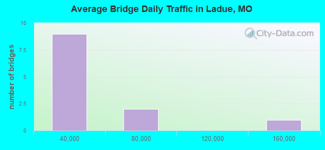
- 391,589Total average daily traffic
- 38,310Total average daily truck traffic
- National Bridge Inventory (NBI) Registered Bridges for Ladue
- No street view available for this location
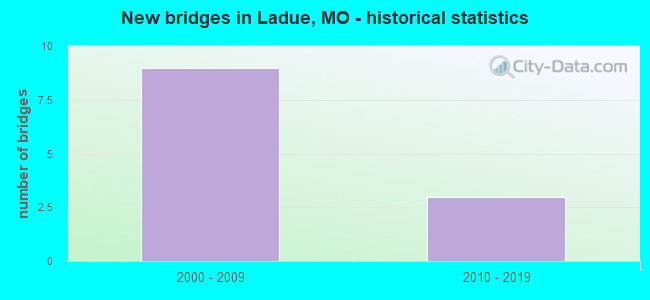
- New bridges - historical statistics
- 92000-2009
- 32010-2019
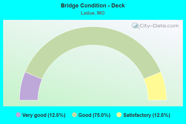
- Bridge Condition - Deck
- 12.5%Very good
- 75.0%Good
- 12.5%Satisfactory
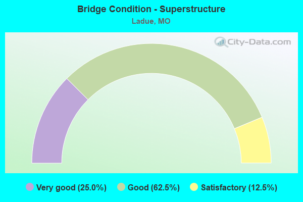
- Bridge Condition - Superstructure
- 25.0%Very good
- 62.5%Good
- 12.5%Satisfactory
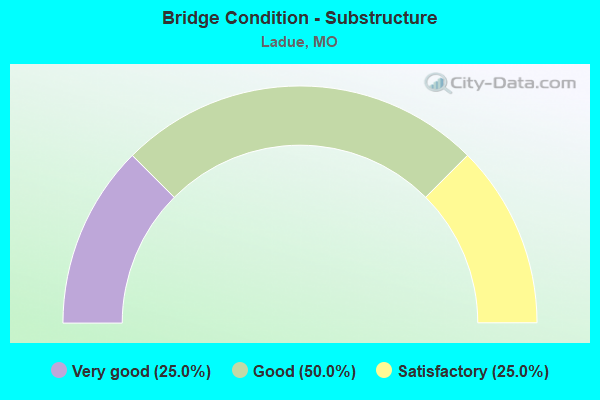
- Bridge Condition - Substructure
- 25.0%Very good
- 50.0%Good
- 25.0%Satisfactory
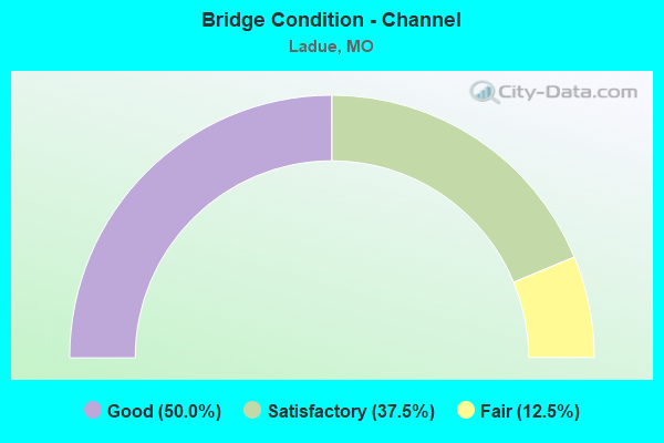
- Bridge Condition - Channel
- 50.0%Good
- 37.5%Satisfactory
- 12.5%Fair
Find on map >> Show street view
Structure Number: 30697, Location: S 28 T 45 N R 6 E (Lat: 38.616119, Lng: -90.362453), Route carried "on" structure: County highway , Year Built: 2004, Status: Posted for load, Structure Length: 3.64m (11.94ft), Average Daily Traffic: 18,796 (year 2020), Truck Traffic: 5%, Average Future Daily Traffic: 25,375 (year 2040), Design Load: HS 20, Features Intersected: DEER CR, Facility Carried by Structure: MCKNIGHT RD
Minimum Vertical Clearance: 30+ m (98+ ft), Kilometerpoint: 0.000, Lanes on structure: 4, Owner: County Highway Agency, Approaching Roadway Width: 16.9m (55.4ft), Material/Design: Prestressed concrete continuous, Design/Construction: Box Beam or Girders - Multiple, Number Of Spans In Main Unit: 3, Length of Maximum Span: 13.7m (44.9ft), Curb-To-Curb Width: 16.4m (53.8ft), Out-to-Out Width: 20.7m (67.9ft)
Condition: Deck: Good, Superstructure: Good, Substructure: Satisfactory, Channel: Satisfactory, Operating Rating: 89.1 metric tons, Method Used To Determine Operating Rating: Load Factor (LF), Inventory Rating: 64.8 metric tons, Method Used To Determine Inventory Rating: Load Factor (LF), Structural Evaluation: Equal to present minimum criteria, Deck Geometry: Meets minimum limits, Waterway Adequacy: Superior to present desirable criteria, Approach Roadway Alignment: Equal to present desirable criteria, Designated Inspection Frequency: Every 24 months, Inspection Date: April 2020, Deck Structure Type: Other, Wearing Surface/Protective System: Wearing Surface: Bituminous, Membrane: Built-up
Find on map >> Show street view
Structure Number: 31362, Location: S 19 T 45 N R 6 E (Lat: 38.621006, Lng: -90.394775), Route carried "on" structure: City street , Year Built: 2004, Status: Open, Structure Length: 2.99m (9.81ft), Average Daily Traffic: 5,564 (year 2020), Truck Traffic: 1%, Average Future Daily Traffic: 7,511 (year 2040), Design Load: HS 20, Features Intersected: TWO MILE CR, Facility Carried by Structure: WARSON RD
Minimum Vertical Clearance: 30+ m (98+ ft), Kilometerpoint: 0.644, Lanes on structure: 2, Owner: City or Municipal Highway Agency, Approaching Roadway Width: 8.5m (27.9ft), Skew: 1 degrees, Material/Design: Prestressed concrete, Design/Construction: Stringer/Multi-beam, Number Of Spans In Main Unit: 1, Length of Maximum Span: 29.9m (98.1ft), Curb or Sidewalk Widths: Left: 0.4m (1.3ft), Right: 0.4m (1.3ft), Curb-To-Curb Width: 7.9m (25.9ft), Out-to-Out Width: 8.8m (28.9ft)
Condition: Deck: Satisfactory, Superstructure: Very good, Substructure: Very good, Channel: Good, Operating Rating: 86.4 metric tons, Method Used To Determine Operating Rating: Load Factor (LF), Inventory Rating: 32.4 metric tons, Method Used To Determine Inventory Rating: Load Factor (LF), Structural Evaluation: Equal to present desirable criteria, Deck Geometry: High priority of replacement, Waterway Adequacy: Superior to present desirable criteria, Approach Roadway Alignment: Equal to present desirable criteria, Designated Inspection Frequency: Every 24 months, Inspection Date: January 2022, Deck Structure Type: Concrete Cast-file-Place, Wearing Surface/Protective System: Deck Protection: Epoxy Coated Reinforcing
Find on map >> Show street view
Structure Number: 31882, Location: S 19 T 45 N R 6 E (Lat: 38.622500, Lng: -90.376083), Route carried "on" structure: City street 231, Year Built: 2007, Status: Open, Structure Length: 3.44m (11.29ft), Average Daily Traffic: 1,920 (year 2020), Truck Traffic: 1%, Average Future Daily Traffic: 2,592 (year 2040), Design Load: HS 20, Features Intersected: DEER CR, Facility Carried by Structure: LITZSINGER RD
Minimum Vertical Clearance: 30+ m (98+ ft), Kilometerpoint: 0.805, Lanes on structure: 2, Owner: City or Municipal Highway Agency, Approaching Roadway Width: 7.9m (25.9ft), Skew: 1 degrees, Material/Design: Prestressed concrete continuous, Design/Construction: Stringer/Multi-beam, Number Of Spans In Main Unit: 2, Length of Maximum Span: 17.1m (56.1ft), Curb or Sidewalk Widths: Left: 1.8m (5.9ft), Right: 0.0m, Curb-To-Curb Width: 7.9m (25.9ft), Out-to-Out Width: 8.8m (28.9ft)
Condition: Deck: Good, Superstructure: Good, Substructure: Good, Channel: Good, Operating Rating: 70.2 metric tons, Method Used To Determine Operating Rating: Load Factor (LF), Inventory Rating: 34.2 metric tons, Method Used To Determine Inventory Rating: Load Factor (LF), Structural Evaluation: Better than present minimum criteria, Deck Geometry: Meets minimum limits, Waterway Adequacy: Equal to present minimum criteria, Approach Roadway Alignment: Equal to present minimum criteria, Designated Inspection Frequency: Every 24 months, Inspection Date: January 2022, Deck Structure Type: Concrete Cast-file-Place, Wearing Surface/Protective System: Wearing Surface: Monolithic Concrete, Deck Protection: Epoxy Coated Reinforcing
Find on map >> Show street view
Structure Number: 32225, Location: S 20 T 45 N R 6 E (Lat: 38.630036, Lng: -90.362275), Route carried "on" structure: City street , Year Built: 2008, Status: Open, Structure Length: 4.45m (14.60ft), Average Daily Traffic: 12,455 (year 2021), Truck Traffic: 5%, Average Future Daily Traffic: 17,437 (year 2041), Design Load: HS 20, Features Intersected: IS 64, Facility Carried by Structure: S MCKNIGHT RD S
Minimum Vertical Clearance: 30+ m (98+ ft), Kilometerpoint: 2.726, Lanes on structure: 4, Lanes under structure: 8, Owner: State Highway Agency, Approaching Roadway Width: 15.8m (51.8ft), Material/Design: Prestressed concrete, Design/Construction: Tee Beam, Number Of Spans In Main Unit: 1, Length of Maximum Span: 21.9m (71.9ft), Curb or Sidewalk Widths: Left: 0.0m, Right: 1.8m (5.9ft), Curb-To-Curb Width: 15.8m (51.8ft), Out-to-Out Width: 18.4m (60.4ft)
Condition: Deck: Good, Superstructure: Good, Substructure: Good, Inventory Rating: 39.6 metric tons, Method Used To Determine Inventory Rating: Load Factor (LF), Structural Evaluation: Better than present minimum criteria, Deck Geometry: Meets minimum limits, Underclear: Meets minimum limits, Approach Roadway Alignment: Equal to present desirable criteria, Designated Inspection Frequency: Every 24 months, Inspection Date: October 2020, Deck Structure Type: Concrete Cast-file-Place, Wearing Surface/Protective System: Wearing Surface: Epoxy Overlay, Deck Protection: Epoxy Coated Reinforcing
Find on map >> Show street view
Structure Number: 32258, Location: S 18 T 45 N R 6 E (Lat: 38.636392, Lng: -90.395314), Route carried "on" structure: Interstate 64, Year Built: 2008, Status: Open, Structure Length: 18.11m (59.42ft), Average Daily Traffic: 147,837 (year 2021), Truck Traffic: 12%, Average Future Daily Traffic: 184,796 (year 2041), Design Load: HS 25 or greater, Features Intersected: CST CLAYTON RD, DEER CRE
Minimum Vertical Clearance: 30+ m (98+ ft), Kilometerpoint: 46.312, Lanes on structure: 8, Lanes under structure: 9, Base Highway Network: Yes, Owner: State Highway Agency, Approaching Roadway Width: 20.5m (67.3ft), Skew: 1 degrees, Material/Design: Prestressed concrete continuous, Design/Construction: Tee Beam, Number Of Spans In Main Unit: 6, Length of Maximum Span: 36.0m (118.1ft), Curb-To-Curb Width: 41.0m (134.5ft), Out-to-Out Width: 41.0m (134.5ft)
Condition: Deck: Good, Superstructure: Satisfactory, Substructure: Satisfactory, Channel: Satisfactory, Operating Rating: 75.6 metric tons, Method Used To Determine Operating Rating: Load Factor (LF), Inventory Rating: 40.5 metric tons, Method Used To Determine Inventory Rating: Load Factor (LF), Structural Evaluation: Equal to present minimum criteria, Deck Geometry: Superior to present desirable criteria, Underclear: High priority of corrective action, Waterway Adequacy: Superior to present desirable criteria, Approach Roadway Alignment: Equal to present desirable criteria, Designated Inspection Frequency: Every 24 months, Inspection Date: October 2020, Deck Structure Type: Concrete Cast-file-Place, Wearing Surface/Protective System: Wearing Surface: Epoxy Overlay, Deck Protection: Epoxy Coated Reinforcing
Find on map >> Show street view
Structure Number: 32897, Location: S 18 T 45 N R 6 E (Lat: 38.636258, Lng: -90.394889), Route carried "on" structure: City street , Year Built: 2010, Status: Open, Structure Length: 3.23m (10.60ft), Average Daily Traffic: 12,346 (year 2020), Truck Traffic: 1%, Average Future Daily Traffic: 16,667 (year 2040), Design Load: HS 20, Features Intersected: DEER CR, Facility Carried by Structure: CLAYTON RD
Minimum Vertical Clearance: 4.67m (15.32ft), Kilometerpoint: 0.483, Lanes on structure: 4, Owner: City or Municipal Highway Agency, Approaching Roadway Width: 15.6m (51.2ft), Skew: 2 degrees, Material/Design: Steel continuous, Design/Construction: Stringer/Multi-beam, Number Of Spans In Main Unit: 2, Length of Maximum Span: 17.7m (58.1ft), Curb-To-Curb Width: 15.6m (51.2ft), Out-to-Out Width: 16.5m (54.1ft)
Condition: Deck: Good, Superstructure: Good, Substructure: Good, Channel: Good, Operating Rating: 71.1 metric tons, Method Used To Determine Operating Rating: Load Factor (LF), Inventory Rating: 42.3 metric tons, Method Used To Determine Inventory Rating: Load Factor (LF), Structural Evaluation: Better than present minimum criteria, Deck Geometry: Meets minimum limits, Waterway Adequacy: Meets minimum limits, Approach Roadway Alignment: Equal to present desirable criteria, Designated Inspection Frequency: Every 24 months, Inspection Date: January 2022, Deck Structure Type: Concrete Cast-file-Place, Wearing Surface/Protective System: Wearing Surface: Monolithic Concrete, Deck Protection: Epoxy Coated Reinforcing
Find on map >> Show street view
Structure Number: 34645, Location: S 1930 T 45 N R 6 E (Lat: 38.614944, Lng: -90.376306), Route carried "on" structure: City street , Year Built: 2006, Status: Open, Structure Length: 1.95m (6.40ft), Average Daily Traffic: 4,000 (year 2020), Truck Traffic: 5%, Average Future Daily Traffic: 5,400 (year 2040), Design Load: HS 20, Features Intersected: SEBAGO CR, Facility Carried by Structure: OLD WARSON RD
Minimum Vertical Clearance: 30+ m (98+ ft), Kilometerpoint: 0.000, Lanes on structure: 2, Owner: City or Municipal Highway Agency, Approaching Roadway Width: 8.8m (28.9ft), Skew: 4 degrees, Material/Design: Aluminum, Iron, Design/Construction: Culvert, Number Of Spans In Main Unit: 2, Length of Maximum Span: 9.1m (29.9ft), Curb-To-Curb Width: 8.8m (28.9ft), Out-to-Out Width: 11.0m (36.1ft)
Condition: Channel: Fair, Culverts: Good, Operating Rating: 54.0 metric tons, Method Used To Determine Operating Rating: Field evaluation and documented engineering judgment, Inventory Rating: 32.4 metric tons, Method Used To Determine Inventory Rating: Field evaluation and documented engineering judgment, Structural Evaluation: Better than present minimum criteria, Deck Geometry: Meets minimum limits, Waterway Adequacy: Superior to present desirable criteria, Approach Roadway Alignment: Equal to present desirable criteria, Designated Inspection Frequency: Every 24 months, Inspection Date: January 2022
Find on map >> Show street view
Structure Number: 34705, Location: S 17 T 45 N R 6 E (Lat: 38.642500, Lng: -90.357778), Route carried "on" structure: City street , Year Built: 2015, Status: Open, Structure Length: 1.62m (5.31ft), Average Daily Traffic: 15,000 (year 2020), Truck Traffic: 1%, Average Future Daily Traffic: 20,250 (year 2040), Features Intersected: TRIB TO BLACK CR, Facility Carried by Structure: MCKNIGHT RD
Minimum Vertical Clearance: 30+ m (98+ ft), Kilometerpoint: 0.161, Lanes on structure: 2, Owner: City or Municipal Highway Agency, Approaching Roadway Width: 7.9m (25.9ft), Material/Design: Prestressed concrete, Design/Construction: Stringer/Multi-beam, Number Of Spans In Main Unit: 1, Length of Maximum Span: 15.2m (49.9ft), Curb or Sidewalk Widths: Left: 0.4m (1.3ft), Right: 2.2m (7.2ft), Curb-To-Curb Width: 9.9m (32.5ft), Out-to-Out Width: 12.4m (40.7ft)
Condition: Deck: Very good, Superstructure: Good, Substructure: Very good, Channel: Good, Operating Rating: 58.5 metric tons, Method Used To Determine Operating Rating: Load Factor (LF), Inventory Rating: 45.0 metric tons, Method Used To Determine Inventory Rating: Load Factor (LF), Structural Evaluation: Better than present minimum criteria, Deck Geometry: Meets minimum limits, Waterway Adequacy: Superior to present desirable criteria, Approach Roadway Alignment: Equal to present desirable criteria, Designated Inspection Frequency: Every 24 months, Inspection Date: January 2022, Deck Structure Type: Concrete Cast-file-Place, Wearing Surface/Protective System: Wearing Surface: Monolithic Concrete, Deck Protection: Epoxy Coated Reinforcing
Find on map >> Show street view
Structure Number: 34706, Location: S 16 T 45 N R 6 E (Lat: 38.650194, Lng: -90.358694), Route carried "on" structure: City street , Year Built: 2014, Status: Open, Structure Length: 0.94m (3.08ft), Average Daily Traffic: 13,988 (year 2020), Truck Traffic: 1%, Average Future Daily Traffic: 18,884 (year 2040), Features Intersected: BLACK CR, Facility Carried by Structure: MCKNIGHT RD
Minimum Vertical Clearance: 30+ m (98+ ft), Kilometerpoint: 1.127, Lanes on structure: 2, Owner: City or Municipal Highway Agency, Approaching Roadway Width: 7.9m (25.9ft), Material/Design: Prestressed concrete, Design/Construction: Box Beam or Girders - Single/Spread, Number Of Spans In Main Unit: 1, Length of Maximum Span: 8.8m (28.9ft), Curb or Sidewalk Widths: Left: 0.4m (1.3ft), Right: 2.2m (7.2ft), Curb-To-Curb Width: 9.8m (32.2ft), Out-to-Out Width: 12.4m (40.7ft)
Condition: Deck: Good, Superstructure: Very good, Substructure: Good, Channel: Satisfactory, Operating Rating: 80.1 metric tons, Method Used To Determine Operating Rating: Load Factor (LF), Inventory Rating: 62.1 metric tons, Method Used To Determine Inventory Rating: Load Factor (LF), Structural Evaluation: Better than present minimum criteria, Deck Geometry: Meets minimum limits, Waterway Adequacy: Somewhat better than minimum adequacy, Approach Roadway Alignment: Equal to present desirable criteria, Designated Inspection Frequency: Every 24 months, Inspection Date: January 2022, Deck Structure Type: Concrete Cast-file-Place, Wearing Surface/Protective System: Wearing Surface: Monolithic Concrete, Deck Protection: Epoxy Coated Reinforcing
Find on map >> Show street view
Structure Number: 32225, Location: S 20 T 45 N R 6 E (Lat: 38.630036, Lng: -90.362275), Route carried "under" structure: Interstate 64, Year Built: 2008, Structure Length: 0. m, Average Daily Traffic: 76,570 (year 2021), Truck Traffic: 12%, Features Intersected: IS 64, Facility Carried by Structure: S MCKNIGHT RD S
Minimum Vertical Clearance: 4.85m (15.91ft), Kilometerpoint: 16.237, Lanes on structure: 4, Lanes under structure: 4, Material/Design: Prestressed concrete, Design/Construction: Tee Beam, Length of Maximum Span: 21.9m (71.9ft)
Find on map >> Show street view
Structure Number: 32225, Location: S 20 T 45 N R 6 E (Lat: 38.630036, Lng: -90.362275), Route carried "under" structure: Interstate 64, Year Built: 2008, Structure Length: 0. m, Average Daily Traffic: 71,157 (year 2021), Truck Traffic: 12%, Features Intersected: IS 64, Facility Carried by Structure: S MCKNIGHT RD S
Minimum Vertical Clearance: 4.85m (15.91ft), Kilometerpoint: 49.463, Lanes on structure: 4, Lanes under structure: 4, Material/Design: Prestressed concrete, Design/Construction: Tee Beam, Length of Maximum Span: 21.9m (71.9ft)
Find on map >> Show street view
Structure Number: 32258, Location: S 18 T 45 N R 6 E (Lat: 38.636392, Lng: -90.395314), Route carried "under" structure: City street , Year Built: 2008, Structure Length: 0. m, Average Daily Traffic: 11,956 (year 2021), Truck Traffic: 5%, Features Intersected: CST CLAYTON RD, Facility Carried by Structure: IS 64 E
Minimum Vertical Clearance: 4.57m (14.99ft), Kilometerpoint: 23.638, Lanes on structure: 8, Lanes under structure: 4, Material/Design: Prestressed concrete continuous, Design/Construction: Tee Beam, Length of Maximum Span: 36.0m (118.1ft)