Bridge Statistics for Lafayette, Colorado (CO)
Condition, Traffic, Stress, Structural Evaluation, Project Costs
- National Bridge Inventory (NBI) Statistics
- 23Number of bridges
- 299ft / 90.6mTotal length
- $380,000Total costs
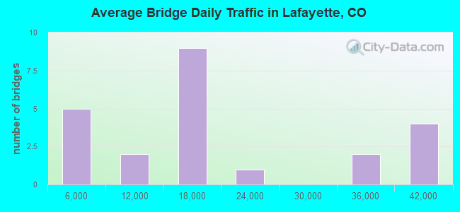
- 396,322Total average daily traffic
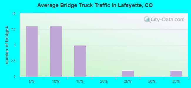
- 23,322Total average daily truck traffic
- National Bridge Inventory (NBI) Registered Bridges for Lafayette
- No street view available for this location
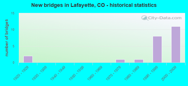
- New bridges - historical statistics
- 21920-1929
- 11970-1979
- 11980-1989
- 81990-1999
- 112000-2009
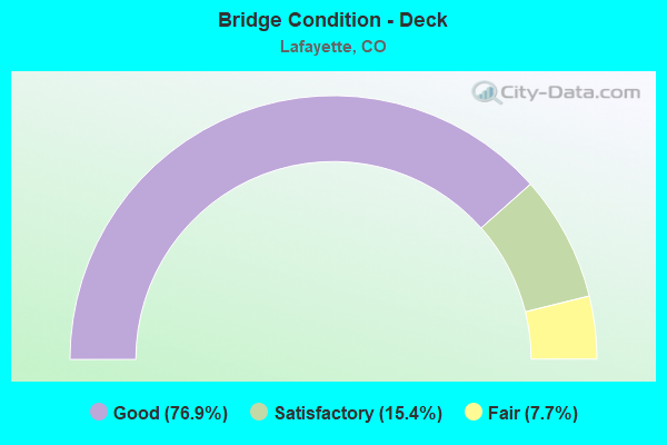
- Bridge Condition - Deck
- 76.9%Good
- 15.4%Satisfactory
- 7.7%Fair
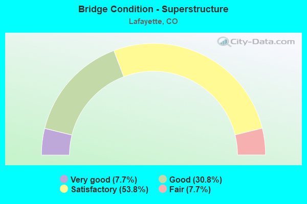
- Bridge Condition - Superstructure
- 7.7%Very good
- 30.8%Good
- 53.8%Satisfactory
- 7.7%Fair
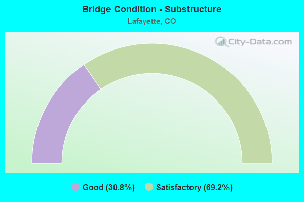
- Bridge Condition - Substructure
- 30.8%Good
- 69.2%Satisfactory
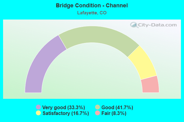
- Bridge Condition - Channel
- 33.3%Very good
- 41.7%Good
- 16.7%Satisfactory
- 8.3%Fair
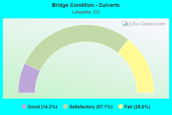
- Bridge Condition - Culverts
- 14.3%Good
- 57.1%Satisfactory
- 28.6%Fair
Find on map >> Show street view
Structure Number: D-16-BW, Location: 0.35 MI E OF 75th ST (Lat: 40.014681, Lng: -105.171467), Route carried "on" structure: State highway 7C, Year Built: 1928, Status: Open, Structure Length: 1.06m (3.48ft), Average Daily Traffic: 19,000 (year 2020), Truck Traffic: 2%, Average Future Daily Traffic: 24,130 (year 2040), Design Load: H 15, Features Intersected: DRAW, Facility Carried by Structure: SH 7 ML
Minimum Vertical Clearance: 30+ m (98+ ft), Kilometerpoint: 7.443, Lanes on structure: 2, Base Highway Network: Yes, Owner: State Highway Agency, Approaching Roadway Width: 8.2m (26.9ft), Skew: 5 degrees, Material/Design: Concrete, Design/Construction: Culvert, Number Of Spans In Main Unit: 2, Length of Maximum Span: 5.1m (16.7ft), Curb-To-Curb Width: 8.9m (29.2ft), Out-to-Out Width: 9.5m (31.2ft)
Condition: Channel: Satisfactory, Culverts: Fair, Operating Rating: 36.3 metric tons, Method Used To Determine Operating Rating: Field evaluation and documented engineering judgment, Inventory Rating: 32.7 metric tons, Method Used To Determine Inventory Rating: Field evaluation and documented engineering judgment, Structural Evaluation: Somewhat better than minimum adequacy, Deck Geometry: High priority of replacement, Waterway Adequacy: Equal to present desirable criteria, Approach Roadway Alignment: Equal to present desirable criteria, Length Of Structure Improvement: 1.06m (3.48ft), Designated Inspection Frequency: Every 24 months, Inspection Date: July 2021, Bridge Improvement Cost: $166,000, Roadway Improvement Cost: $17,000, Total Project Cost: $183,000 ( Estimate for 2019)
Find on map >> Show street view
Structure Number: D-16-DM, Location: 2.3 MI E OF JCT US 287 (Lat: 40.000314, Lng: -105.058450), Route carried "on" structure: State highway 7D, Year Built: 1990, Status: Open, Structure Length: 4.45m (14.60ft), Average Daily Traffic: 17,000 (year 2020), Truck Traffic: 4%, Average Future Daily Traffic: 22,440 (year 2040), Design Load: HS 20, Features Intersected: COAL CREEK, Facility Carried by Structure: SH 7 ML
Minimum Vertical Clearance: 30+ m (98+ ft), Kilometerpoint: 3.792, Lanes on structure: 2, Base Highway Network: Yes, Owner: State Highway Agency, Approaching Roadway Width: 13.4m (44.0ft), Material/Design: Prestressed concrete continuous, Design/Construction: Box Beam or Girders - Single/Spread, Number Of Spans In Main Unit: 2, Length of Maximum Span: 21.6m (70.9ft), Curb-To-Curb Width: 13.4m (44.0ft), Out-to-Out Width: 14.2m (46.6ft)
Condition: Deck: Good, Superstructure: Very good, Substructure: Good, Channel: Satisfactory, Operating Rating: 30.8 metric tons, Method Used To Determine Operating Rating: Load and Resistance Factor Rating (LRFR) rating reported by rating factor(RF) method using HL-93 loadings, Inventory Rating: 23.7 metric tons, Method Used To Determine Inventory Rating: Load and Resistance Factor Rating (LRFR) rating reported by rating factor(RF) method using HL-93 loadings, Structural Evaluation: Somewhat better than minimum adequacy, Deck Geometry: Equal to present minimum criteria, Waterway Adequacy: Equal to present desirable criteria, Approach Roadway Alignment: Equal to present desirable criteria, Designated Inspection Frequency: Every 48 months, Inspection Date: March 2019, Deck Structure Type: Concrete Cast-file-Place, Wearing Surface/Protective System: Wearing Surface: Bituminous, Membrane: Preformed Fabric, Deck Protection: Epoxy Coated Reinforcing
Find on map >> Show street view
Structure Number: E-16-MT, Location: 0.4 MI S of NW PKWY (Lat: 39.952000, Lng: -105.090100), Route carried "on" structure: US 287C, Year Built: 1993, Status: Open, Structure Length: 3.41m (11.19ft), Average Daily Traffic: 16,500 (year 2020), Truck Traffic: 4%, Average Future Daily Traffic: 19,470 (year 2040), Design Load: HS 20, Features Intersected: ROCK CREEK, Facility Carried by Structure: US 287 NBND
Minimum Vertical Clearance: 30+ m (98+ ft), Kilometerpoint: 28.691, Lanes on structure: 2, Base Highway Network: Yes, Owner: State Highway Agency, Approaching Roadway Width: 11.6m (38.1ft), Skew: 3 degrees, Material/Design: Prestressed concrete, Design/Construction: Stringer/Multi-beam, Number Of Spans In Main Unit: 1, Length of Maximum Span: 33.0m (108.3ft), Curb-To-Curb Width: 11.6m (38.1ft), Out-to-Out Width: 12.3m (40.4ft)
Condition: Deck: Good, Superstructure: Good, Substructure: Good, Channel: Good, Operating Rating: 54.5 metric tons, Method Used To Determine Operating Rating: Load Factor (LF), Inventory Rating: 39.9 metric tons, Method Used To Determine Inventory Rating: Load Factor (LF), Structural Evaluation: Better than present minimum criteria, Deck Geometry: Better than present minimum criteria, Waterway Adequacy: Equal to present desirable criteria, Approach Roadway Alignment: Equal to present desirable criteria, Designated Inspection Frequency: Every 24 months, Inspection Date: March 2021, Deck Structure Type: Concrete Cast-file-Place, Wearing Surface/Protective System: Wearing Surface: Bituminous, Membrane: Built-up, Deck Protection: Epoxy Coated Reinforcing
Find on map >> Show street view
Structure Number: E-16-NG, Location: JUST N OF NW PKWY (Lat: 39.961317, Lng: -105.090006), Route carried "on" structure: US 287C, Year Built: 1993, Status: Open, Structure Length: 0.76m (2.49ft), Average Daily Traffic: 39,000 (year 2020), Truck Traffic: 4%, Average Future Daily Traffic: 48,750 (year 2040), Design Load: HS 20, Features Intersected: DRAW, Facility Carried by Structure: US 287
Minimum Vertical Clearance: 30+ m (98+ ft), Kilometerpoint: 29.728, Lanes on structure: 5, Base Highway Network: Yes, Owner: State Highway Agency, Approaching Roadway Width: 26.8m (87.9ft), Material/Design: Concrete, Design/Construction: Culvert, Number Of Spans In Main Unit: 2, Length of Maximum Span: 4.0m (13.1ft), Out-to-Out Width: 44.5m (146.0ft)
Condition: Channel: Very good, Culverts: Good, Operating Rating: 36.3 metric tons, Method Used To Determine Operating Rating: Field evaluation and documented engineering judgment, Inventory Rating: 32.7 metric tons, Method Used To Determine Inventory Rating: Field evaluation and documented engineering judgment, Structural Evaluation: Better than present minimum criteria, Waterway Adequacy: Equal to present desirable criteria, Approach Roadway Alignment: Equal to present desirable criteria, Length Of Structure Improvement: 0.76m (2.49ft), Designated Inspection Frequency: Every 24 months, Inspection Date: March 2021, Bridge Improvement Cost: $131,000, Roadway Improvement Cost: $13,000, Total Project Cost: $197,000
Find on map >> Show street view
Structure Number: E-16-NH, Location: IN BOULDER COUNTY (Lat: 39.965319, Lng: -105.090061), Route carried "on" structure: US 287C, Year Built: 1994, Status: Open, Structure Length: 0.98m (3.22ft), Average Daily Traffic: 39,000 (year 2020), Truck Traffic: 4%, Average Future Daily Traffic: 48,750 (year 2040), Design Load: HS 20, Features Intersected: DRAW, Facility Carried by Structure: US 287 ML
Minimum Vertical Clearance: 30+ m (98+ ft), Kilometerpoint: 30.172, Lanes on structure: 6, Base Highway Network: Yes, Owner: State Highway Agency, Approaching Roadway Width: 28.7m (94.2ft), Material/Design: Concrete, Design/Construction: Culvert, Number Of Spans In Main Unit: 3, Length of Maximum Span: 2.9m (9.5ft), Out-to-Out Width: 45.1m (148.0ft)
Condition: Channel: Very good, Culverts: Satisfactory, Operating Rating: 36.3 metric tons, Method Used To Determine Operating Rating: Field evaluation and documented engineering judgment, Inventory Rating: 32.7 metric tons, Method Used To Determine Inventory Rating: Field evaluation and documented engineering judgment, Structural Evaluation: Equal to present minimum criteria, Waterway Adequacy: Equal to present desirable criteria, Approach Roadway Alignment: Equal to present desirable criteria, Designated Inspection Frequency: Every 24 months, Inspection Date: April 2021
Find on map >> Show street view
Structure Number: E-16-PN, Location: IN BOULDER COUNTY (Lat: 39.979722, Lng: -105.097528), Route carried "on" structure: US 287C, Year Built: 1996, Status: Open, Structure Length: 4.30m (14.11ft), Average Daily Traffic: 32,000 (year 2020), Truck Traffic: 4%, Average Future Daily Traffic: 42,880 (year 2040), Features Intersected: COAL CREEK, Facility Carried by Structure: US 287 ML
Minimum Vertical Clearance: 30+ m (98+ ft), Kilometerpoint: 32.113, Lanes on structure: 4, Base Highway Network: Yes, Owner: State Highway Agency, Approaching Roadway Width: 23.2m (76.1ft), Skew: 10 degrees, Material/Design: Prestressed concrete continuous, Design/Construction: Stringer/Multi-beam, Number Of Spans In Main Unit: 2, Length of Maximum Span: 21.1m (69.2ft), Curb or Sidewalk Widths: Left: 2.9m (9.5ft), Right: 0.0m, Curb-To-Curb Width: 23.2m (76.1ft), Out-to-Out Width: 31.7m (104.0ft)
Condition: Deck: Good, Superstructure: Good, Substructure: Good, Channel: Very good, Operating Rating: 60.7 metric tons, Method Used To Determine Operating Rating: Load Factor (LF), Inventory Rating: 23.1 metric tons, Method Used To Determine Inventory Rating: Load Factor (LF), Structural Evaluation: Somewhat better than minimum adequacy, Deck Geometry: Superior to present desirable criteria, Waterway Adequacy: Superior to present desirable criteria, Approach Roadway Alignment: Equal to present desirable criteria, Designated Inspection Frequency: Every 24 months, Inspection Date: December 2021, Deck Structure Type: Concrete Precast Panels, Wearing Surface/Protective System: Wearing Surface: Monolithic Concrete, Membrane: Other, Deck Protection: Epoxy Coated Reinforcing
Find on map >> Show street view
Structure Number: E-16-PO, Location: IN LAFAYETTE (Lat: 39.986814, Lng: -105.098847), Route carried "on" structure: ServiceUS 287C, Year Built: 1996, Status: Open, Structure Length: 0.61m (2.00ft), Average Daily Traffic: 34,000 (year 2020), Truck Traffic: 4%, Average Future Daily Traffic: 44,880 (year 2040), Design Load: HS 20, Features Intersected: DRAINAGE DITCH AR, Facility Carried by Structure: SOUTH BOULDER RD
Minimum Vertical Clearance: 30+ m (98+ ft), Kilometerpoint: 1.518, Lanes on structure: 8, Base Highway Network: Yes, Owner: State Highway Agency, Approaching Roadway Width: 29.3m (96.1ft), Material/Design: Concrete, Design/Construction: Culvert, Number Of Spans In Main Unit: 1, Length of Maximum Span: 6.1m (20.0ft), Out-to-Out Width: 28.0m (91.9ft)
Condition: Channel: Good, Culverts: Satisfactory, Operating Rating: 36.3 metric tons, Method Used To Determine Operating Rating: Load Factor (LF), Inventory Rating: 32.7 metric tons, Method Used To Determine Inventory Rating: Load Factor (LF), Structural Evaluation: Equal to present minimum criteria, Waterway Adequacy: Somewhat better than minimum adequacy, Approach Roadway Alignment: Equal to present desirable criteria, Designated Inspection Frequency: Every 24 months, Inspection Date: December 2021
Find on map >> Show street view
Structure Number: E-16-PQ, Location: IN LAFAYETTE (Lat: 39.994100, Lng: -105.102836), Route carried "on" structure: City street , Year Built: 1994, Status: Open, Structure Length: 6.19m (20.31ft), Average Daily Traffic: 3,129 (year 2020), Truck Traffic: 1%, Average Future Daily Traffic: 4,000 (year 2028), Design Load: HS 20, Features Intersected: US 287 ML, Facility Carried by Structure: EMMA ST.
Minimum Vertical Clearance: 30+ m (98+ ft), Kilometerpoint: 0.423, Lanes on structure: 2, Lanes under structure: 4, Owner: State Highway Agency, Approaching Roadway Width: 16.8m (55.1ft), Skew: 3 degrees, Material/Design: Prestressed concrete continuous, Design/Construction: Box Beam or Girders - Multiple, Number Of Spans In Main Unit: 2, Length of Maximum Span: 29.9m (98.1ft), Curb or Sidewalk Widths: Left: 2.7m (8.9ft), Right: 2.7m (8.9ft), Curb-To-Curb Width: 11.3m (37.1ft), Out-to-Out Width: 16.8m (55.1ft)
Condition: Deck: Satisfactory, Superstructure: Satisfactory, Substructure: Satisfactory, Operating Rating: 76.2 metric tons, Method Used To Determine Operating Rating: Load Factor (LF), Inventory Rating: 45.4 metric tons, Method Used To Determine Inventory Rating: Load Factor (LF), Structural Evaluation: Equal to present minimum criteria, Deck Geometry: Somewhat better than minimum adequacy, Underclear: Better than present minimum criteria, Approach Roadway Alignment: Equal to present desirable criteria, Designated Inspection Frequency: Every 24 months, Inspection Date: December 2021, Deck Structure Type: Other, Wearing Surface/Protective System: Wearing Surface: Bituminous, Membrane: Preformed Fabric, Deck Protection: Epoxy Coated Reinforcing
Find on map >> Show street view
Structure Number: LAF-120TH-001B, Location: 0.5 Mi S of S. Boulder Rd (Lat: 39.977111, Lng: -105.072000), Route carried "on" structure: City street , Year Built: 1986, Year Reconstructed: 2000, Status: Open, Structure Length: 1.26m (4.13ft), Average Daily Traffic: 4,287 (year 2020), Truck Traffic: 30%, Average Future Daily Traffic: 5,144 (year 2040), Design Load: HS 20, Features Intersected: Rock Creek, Facility Carried by Structure: 120TH STREET
Minimum Vertical Clearance: 30+ m (98+ ft), Kilometerpoint: 0.536, Lanes on structure: 3, Owner: City or Municipal Highway Agency, Approaching Roadway Width: 15.2m (49.9ft), Skew: 3 degrees, Material/Design: Concrete, Design/Construction: Culvert, Number Of Spans In Main Unit: 2, Length of Maximum Span: 6.1m (20.0ft), Curb or Sidewalk Widths: Left: 1.6m (5.2ft), Right: 2.1m (6.9ft), Curb-To-Curb Width: 15.2m (49.9ft), Out-to-Out Width: 21.4m (70.2ft)
Condition: Channel: Very good, Culverts: Satisfactory, Operating Rating: 30.5 metric tons, Method Used To Determine Operating Rating: Load Factor (LF), Inventory Rating: 18.2 metric tons, Method Used To Determine Inventory Rating: Load Factor (LF), Structural Evaluation: Somewhat better than minimum adequacy, Deck Geometry: Equal to present minimum criteria, Waterway Adequacy: Better than present minimum criteria, Approach Roadway Alignment: Equal to present desirable criteria, Designated Inspection Frequency: Every 24 months, Inspection Date: January 2021
Find on map >> Show street view
Structure Number: LAF-120TH-002, Location: 0.25 M S of S. Boulder Rd (Lat: 39.982333, Lng: -105.071889), Route carried "on" structure: City street , Year Built: 1977, Status: Open, Structure Length: 1.37m (4.49ft), Average Daily Traffic: 8,495 (year 2020), Truck Traffic: 24%, Average Future Daily Traffic: 10,194 (year 2040), Design Load: HS 20, Features Intersected: Coal Creek, Facility Carried by Structure: 120TH STREET
Minimum Vertical Clearance: 30+ m (98+ ft), Kilometerpoint: 1.066, Lanes on structure: 2, Owner: City or Municipal Highway Agency, Approaching Roadway Width: 7.9m (25.9ft), Skew: 1 degrees, Material/Design: Concrete, Design/Construction: Culvert, Number Of Spans In Main Unit: 3, Length of Maximum Span: 5.0m (16.4ft), Out-to-Out Width: 10.4m (34.1ft)
Condition: Channel: Good, Culverts: Fair, Operating Rating: 36.3 metric tons, Method Used To Determine Operating Rating: Field evaluation and documented engineering judgment, Inventory Rating: 32.7 metric tons, Method Used To Determine Inventory Rating: Field evaluation and documented engineering judgment, Structural Evaluation: Somewhat better than minimum adequacy, Waterway Adequacy: Equal to present desirable criteria, Approach Roadway Alignment: Equal to present desirable criteria, Designated Inspection Frequency: Every 24 months, Inspection Date: January 2021, Deck Structure Type: Concrete Cast-file-Place, Wearing Surface/Protective System: Wearing Surface: Bituminous
Find on map >> Show street view
Structure Number: LAF-HORIZ-004, Location: .1 MI East 120th (Lat: 39.980222, Lng: -105.070278), Route carried "on" structure: City street , Year Built: 2000, Status: Open, Structure Length: 2.32m (7.61ft), Average Daily Traffic: 2,284 (year 2020), Truck Traffic: 11%, Average Future Daily Traffic: 2,741 (year 2040), Design Load: HS 20, Features Intersected: Rock Creek, Facility Carried by Structure: Horizon Avenue
Minimum Vertical Clearance: 30+ m (98+ ft), Kilometerpoint: 0.135, Lanes on structure: 2, Owner: City or Municipal Highway Agency, Approaching Roadway Width: 11.0m (36.1ft), Material/Design: Concrete, Design/Construction: Culvert, Number Of Spans In Main Unit: 4, Length of Maximum Span: 6.1m (20.0ft), Curb or Sidewalk Widths: Left: 0.7m (2.3ft), Right: 2.4m (7.9ft), Curb-To-Curb Width: 11.0m (36.1ft), Out-to-Out Width: 14.6m (47.9ft)
Condition: Channel: Fair, Culverts: Satisfactory, Inventory Rating: 64.8 metric tons, Method Used To Determine Inventory Rating: Load Factor (LF), Structural Evaluation: Equal to present minimum criteria, Deck Geometry: Somewhat better than minimum adequacy, Waterway Adequacy: Better than present minimum criteria, Approach Roadway Alignment: Equal to present desirable criteria, Designated Inspection Frequency: Every 24 months, Inspection Date: January 2021
Find on map >> Show street view
Structure Number: LAF-PUBRD-003, Location: .25 M N of Jct US Hwy 287 (Lat: 39.979639, Lng: -105.090556), Route carried "on" structure: City street , Year Built: 1927, Year Reconstructed: 2000, Status: Open, Structure Length: 1.40m (4.59ft), Average Daily Traffic: 17,986 (year 2020), Truck Traffic: 9%, Average Future Daily Traffic: 21,583 (year 2040), Design Load: H 15, Features Intersected: Coal Creek, Facility Carried by Structure: Public Road
Minimum Vertical Clearance: 30+ m (98+ ft), Kilometerpoint: 1.169, Lanes on structure: 2, Owner: City or Municipal Highway Agency, Approaching Roadway Width: 8.8m (28.9ft), Material/Design: Concrete, Design/Construction: Tee Beam, Number Of Spans In Main Unit: 1, Length of Maximum Span: 12.2m (40.0ft), Curb or Sidewalk Widths: Left: 1.5m (4.9ft), Right: 0.0m, Curb-To-Curb Width: 12.0m (39.4ft), Out-to-Out Width: 14.7m (48.2ft)
Condition: Deck: Fair, Superstructure: Fair, Substructure: Satisfactory, Channel: Good, Operating Rating: 36.3 metric tons, Method Used To Determine Operating Rating: Field evaluation and documented engineering judgment, Inventory Rating: 31.1 metric tons, Method Used To Determine Inventory Rating: Load Factor (LF), Structural Evaluation: Somewhat better than minimum adequacy, Deck Geometry: Somewhat better than minimum adequacy, Waterway Adequacy: Equal to present desirable criteria, Approach Roadway Alignment: Equal to present minimum criteria, Designated Inspection Frequency: Every 24 months, Inspection Date: January 2021, Deck Structure Type: Concrete Cast-file-Place, Wearing Surface/Protective System: Wearing Surface: Bituminous, Membrane: Built-up
Find on map >> Show street view
Structure Number: NWP-05.69, Location: 5.69 MI FROM I-25 (Lat: 39.958525, Lng: -105.095539), Route carried "on" structure: Ramp Other road 470N, Year Built: 2002, Status: Open, Structure Length: 5.73m (18.80ft), Average Daily Traffic: 12,000 (year 2018), Truck Traffic: 5%, Average Future Daily Traffic: 16,320 (year 2038), Design Load: HS 25 or greater, Features Intersected: Rock Creek, Facility Carried by Structure: NWP Ramp
Minimum Vertical Clearance: 30.17m (98.98ft), Kilometerpoint: 10.029, Lanes on structure: 2, Base Highway Network: Yes, Toll: On toll road, Owner: Local Toll Authority, Approaching Roadway Width: 11.9m (39.0ft), Skew: 3 degrees, Material/Design: Prestressed concrete continuous, Design/Construction: Stringer/Multi-beam, Number Of Spans In Main Unit: 2, Length of Maximum Span: 42.6m (139.8ft), Curb-To-Curb Width: 11.6m (38.1ft), Out-to-Out Width: 12.5m (41.0ft)
Condition: Deck: Good, Superstructure: Satisfactory, Substructure: Good, Channel: Good, Operating Rating: 36.3 metric tons, Method Used To Determine Operating Rating: Field evaluation and documented engineering judgment, Inventory Rating: 32.7 metric tons, Method Used To Determine Inventory Rating: Field evaluation and documented engineering judgment, Structural Evaluation: Equal to present minimum criteria, Deck Geometry: Superior to present desirable criteria, Waterway Adequacy: Equal to present desirable criteria, Approach Roadway Alignment: Equal to present desirable criteria, Designated Inspection Frequency: Every 24 months, Inspection Date: June 2021, Deck Structure Type: Concrete Cast-file-Place, Wearing Surface/Protective System: Wearing Surface: Bituminous, Deck Protection: Epoxy Coated Reinforcing
Find on map >> Show street view
Structure Number: NWP-05.81A, Location: 5.81 MI FROM I-25 (Lat: 39.958611, Lng: -105.088056), Route carried "on" structure: Other road 470N, Year Built: 2002, Status: Open, Structure Length: 6.84m (22.44ft), Average Daily Traffic: 12,000 (year 2018), Truck Traffic: 10%, Average Future Daily Traffic: 16,320 (year 2038), Design Load: HS 25 or greater, Features Intersected: BNSF, Facility Carried by Structure: NWP EB
Minimum Vertical Clearance: 30.18m (99.02ft), Kilometerpoint: 9.394, Lanes on structure: 2, Base Highway Network: Yes, Toll: On toll road, Owner: Local Toll Authority, Approaching Roadway Width: 12.2m (40.0ft), Skew: 2 degrees, Material/Design: Prestressed concrete continuous, Design/Construction: Stringer/Multi-beam, Number Of Spans In Main Unit: 3, Length of Maximum Span: 24.2m (79.4ft), Curb-To-Curb Width: 12.2m (40.0ft), Out-to-Out Width: 13.1m (43.0ft)
Condition: Deck: Good, Superstructure: Satisfactory, Substructure: Satisfactory, Operating Rating: 70.1 metric tons, Method Used To Determine Operating Rating: Load Factor (LF), Inventory Rating: 42.1 metric tons, Method Used To Determine Inventory Rating: Load Factor (LF), Structural Evaluation: Equal to present minimum criteria, Deck Geometry: Better than present minimum criteria, Underclear: Superior to present desirable criteria, Approach Roadway Alignment: Equal to present desirable criteria, Designated Inspection Frequency: Every 24 months, Inspection Date: May 2021, Deck Structure Type: Concrete Precast Panels, Wearing Surface/Protective System: Wearing Surface: Bituminous, Membrane: Preformed Fabric, Deck Protection: Epoxy Coated Reinforcing
Find on map >> Show street view
Structure Number: NWP-05.81B, Location: 5.81 MI FROM I-25 (Lat: 39.958889, Lng: -105.087778), Route carried "on" structure: Other road 470N, Year Built: 2002, Status: Open, Structure Length: 6.84m (22.44ft), Average Daily Traffic: 12,000 (year 2018), Truck Traffic: 10%, Average Future Daily Traffic: 16,320 (year 2038), Design Load: HS 25 or greater, Features Intersected: BNSF, Facility Carried by Structure: NWP WB
Minimum Vertical Clearance: 30.17m (98.98ft), Kilometerpoint: 9.366, Lanes on structure: 2, Base Highway Network: Yes, Toll: On toll road, Owner: Local Toll Authority, Approaching Roadway Width: 12.2m (40.0ft), Skew: 2 degrees, Material/Design: Prestressed concrete continuous, Design/Construction: Stringer/Multi-beam, Number Of Spans In Main Unit: 3, Length of Maximum Span: 24.2m (79.4ft), Curb-To-Curb Width: 12.2m (40.0ft), Out-to-Out Width: 13.1m (43.0ft)
Condition: Deck: Satisfactory, Superstructure: Satisfactory, Substructure: Satisfactory, Operating Rating: 70.1 metric tons, Method Used To Determine Operating Rating: Load Factor (LF), Inventory Rating: 42.1 metric tons, Method Used To Determine Inventory Rating: Load Factor (LF), Structural Evaluation: Equal to present minimum criteria, Deck Geometry: Better than present minimum criteria, Underclear: Superior to present desirable criteria, Approach Roadway Alignment: Equal to present desirable criteria, Designated Inspection Frequency: Every 24 months, Inspection Date: May 2021, Deck Structure Type: Concrete Precast Panels, Wearing Surface/Protective System: Wearing Surface: Bituminous, Membrane: Preformed Fabric, Deck Protection: Epoxy Coated Reinforcing
Find on map >> Show street view
Structure Number: NWP-05.95A, Location: 5.95 FROM I-25 (Lat: 39.958333, Lng: -105.090556), Route carried "on" structure: Other road 470N, Year Built: 2002, Status: Open, Structure Length: 7.51m (24.64ft), Average Daily Traffic: 12,000 (year 2018), Truck Traffic: 10%, Average Future Daily Traffic: 16,320 (year 2038), Design Load: HS 25 or greater, Features Intersected: US 287, Facility Carried by Structure: NWP EB
Minimum Vertical Clearance: 30.17m (98.98ft), Kilometerpoint: 9.606, Lanes on structure: 2, Lanes under structure: 8, Base Highway Network: Yes, Toll: On toll road, Owner: Local Toll Authority, Approaching Roadway Width: 11.6m (38.1ft), Material/Design: Prestressed concrete continuous, Design/Construction: Stringer/Multi-beam, Number Of Spans In Main Unit: 2, Length of Maximum Span: 36.1m (118.4ft), Curb-To-Curb Width: 11.6m (38.1ft), Out-to-Out Width: 12.5m (41.0ft)
Condition: Deck: Good, Superstructure: Good, Substructure: Satisfactory, Operating Rating: 68.2 metric tons, Method Used To Determine Operating Rating: Load Factor (LF), Inventory Rating: 40.9 metric tons, Method Used To Determine Inventory Rating: Load Factor (LF), Structural Evaluation: Equal to present minimum criteria, Deck Geometry: Equal to present minimum criteria, Underclear: Superior to present desirable criteria, Approach Roadway Alignment: Equal to present desirable criteria, Designated Inspection Frequency: Every 24 months, Inspection Date: June 2021, Deck Structure Type: Concrete Precast Panels, Wearing Surface/Protective System: Wearing Surface: Bituminous, Membrane: Preformed Fabric, Deck Protection: Epoxy Coated Reinforcing
Find on map >> Show street view
Structure Number: NWP-05.95B, Location: 5.95 FROM I-25 (Lat: 39.958611, Lng: -105.090556), Route carried "on" structure: Other road 470N, Year Built: 2002, Status: Open, Structure Length: 7.51m (24.64ft), Average Daily Traffic: 12,000 (year 2018), Truck Traffic: 10%, Average Future Daily Traffic: 16,320 (year 2038), Design Load: HS 25 or greater, Features Intersected: US 287, Facility Carried by Structure: NWP WB
Minimum Vertical Clearance: 30.17m (98.98ft), Kilometerpoint: 9.605, Lanes on structure: 2, Lanes under structure: 8, Base Highway Network: Yes, Toll: On toll road, Owner: Local Toll Authority, Approaching Roadway Width: 11.6m (38.1ft), Material/Design: Prestressed concrete continuous, Design/Construction: Stringer/Multi-beam, Number Of Spans In Main Unit: 2, Length of Maximum Span: 36.1m (118.4ft), Curb-To-Curb Width: 11.6m (38.1ft), Out-to-Out Width: 12.5m (41.0ft)
Condition: Deck: Good, Superstructure: Good, Substructure: Satisfactory, Operating Rating: 68.2 metric tons, Method Used To Determine Operating Rating: Load Factor (LF), Inventory Rating: 40.9 metric tons, Method Used To Determine Inventory Rating: Load Factor (LF), Structural Evaluation: Equal to present minimum criteria, Deck Geometry: Equal to present minimum criteria, Underclear: Better than present minimum criteria, Approach Roadway Alignment: Equal to present desirable criteria, Designated Inspection Frequency: Every 24 months, Inspection Date: May 2021, Deck Structure Type: Concrete Precast Panels, Wearing Surface/Protective System: Wearing Surface: Bituminous, Membrane: Preformed Fabric, Deck Protection: Epoxy Coated Reinforcing
Find on map >> Show street view
Structure Number: NWP-06.25A, Location: 6.25 MI FROM I-25 (Lat: 39.958317, Lng: -105.095539), Route carried "on" structure: Other road NWPKY, Year Built: 2002, Status: Open, Structure Length: 9.60m (31.50ft), Average Daily Traffic: 6,268 (year 2020), Truck Traffic: 5%, Average Future Daily Traffic: 15,960 (year 2038), Design Load: HS 25 or greater, Features Intersected: EB Dillon Road, Facility Carried by Structure: NWP EB
Minimum Vertical Clearance: 30.17m (98.98ft), Kilometerpoint: 10.031, Lanes on structure: 2, Lanes under structure: 1, Base Highway Network: Yes, Toll: On toll road, Owner: Local Toll Authority, Approaching Roadway Width: 11.6m (38.1ft), Skew: 5 degrees, Material/Design: Prestressed concrete continuous, Design/Construction: Stringer/Multi-beam, Number Of Spans In Main Unit: 3, Length of Maximum Span: 44.6m (146.3ft), Curb-To-Curb Width: 11.6m (38.1ft), Out-to-Out Width: 12.5m (41.0ft)
Condition: Deck: Good, Superstructure: Satisfactory, Substructure: Satisfactory, Operating Rating: 36.3 metric tons, Method Used To Determine Operating Rating: Field evaluation and documented engineering judgment, Inventory Rating: 32.7 metric tons, Method Used To Determine Inventory Rating: Field evaluation and documented engineering judgment, Structural Evaluation: Equal to present minimum criteria, Deck Geometry: Equal to present minimum criteria, Underclear: Superior to present desirable criteria, Approach Roadway Alignment: Equal to present desirable criteria, Designated Inspection Frequency: Every 24 months, Inspection Date: June 2021, Deck Structure Type: Concrete Cast-file-Place, Wearing Surface/Protective System: Wearing Surface: Bituminous, Deck Protection: Epoxy Coated Reinforcing
Find on map >> Show street view
Structure Number: NWP-06.25B, Location: 6.25 MI FROM I-25 (Lat: 39.958478, Lng: -105.095933), Route carried "on" structure: Other road NWPKY, Year Built: 2002, Status: Open, Structure Length: 9.60m (31.50ft), Average Daily Traffic: 12,000 (year 2018), Truck Traffic: 5%, Average Future Daily Traffic: 16,320 (year 2038), Design Load: HS 25 or greater, Features Intersected: EB Dillon Road, Facility Carried by Structure: NWP WB
Minimum Vertical Clearance: 30.17m (98.98ft), Kilometerpoint: 10.063, Lanes on structure: 2, Lanes under structure: 1, Base Highway Network: Yes, Toll: On toll road, Owner: Local Toll Authority, Approaching Roadway Width: 11.6m (38.1ft), Skew: 5 degrees, Material/Design: Prestressed concrete continuous, Design/Construction: Stringer/Multi-beam, Number Of Spans In Main Unit: 3, Length of Maximum Span: 44.6m (146.3ft), Curb-To-Curb Width: 11.6m (38.1ft), Out-to-Out Width: 12.5m (41.0ft)
Condition: Deck: Good, Superstructure: Satisfactory, Substructure: Satisfactory, Operating Rating: 36.3 metric tons, Method Used To Determine Operating Rating: Field evaluation and documented engineering judgment, Inventory Rating: 32.7 metric tons, Method Used To Determine Inventory Rating: Field evaluation and documented engineering judgment, Structural Evaluation: Equal to present minimum criteria, Deck Geometry: Equal to present minimum criteria, Underclear: Superior to present desirable criteria, Approach Roadway Alignment: Equal to present desirable criteria, Designated Inspection Frequency: Every 24 months, Inspection Date: June 2021, Deck Structure Type: Concrete Cast-file-Place, Wearing Surface/Protective System: Wearing Surface: Bituminous, Deck Protection: Epoxy Coated Reinforcing
Find on map >> Show street view
Structure Number: NWP-06.29, Location: 6.29 MI FROM I-25 (Lat: 39.958772, Lng: -105.096544), Route carried "on" structure: Ramp Other road 470N, Year Built: 2002, Status: Open, Structure Length: 8.90m (29.20ft), Average Daily Traffic: 1,100 (year 2018), Truck Traffic: 5%, Average Future Daily Traffic: 10,000 (year 2029), Design Load: HS 25 or greater, Features Intersected: EB Dillon Road, Facility Carried by Structure: NWP Ramp
Minimum Vertical Clearance: 30.17m (98.98ft), Kilometerpoint: 0.317, Lanes on structure: 1, Lanes under structure: 1, Base Highway Network: Yes, Toll: On toll road, Owner: Local Toll Authority, Approaching Roadway Width: 9.1m (29.9ft), Skew: 5 degrees, Material/Design: Prestressed concrete continuous, Design/Construction: Stringer/Multi-beam, Number Of Spans In Main Unit: 3, Length of Maximum Span: 40.4m (132.5ft), Curb-To-Curb Width: 11.9m (39.0ft), Out-to-Out Width: 12.8m (42.0ft)
Condition: Deck: Good, Superstructure: Satisfactory, Substructure: Satisfactory, Operating Rating: 36.3 metric tons, Method Used To Determine Operating Rating: Field evaluation and documented engineering judgment, Inventory Rating: 32.7 metric tons, Method Used To Determine Inventory Rating: Field evaluation and documented engineering judgment, Structural Evaluation: Equal to present minimum criteria, Deck Geometry: Superior to present desirable criteria, Underclear: Superior to present desirable criteria, Approach Roadway Alignment: Equal to present desirable criteria, Designated Inspection Frequency: Every 24 months, Inspection Date: June 2021, Deck Structure Type: Concrete Cast-file-Place, Wearing Surface/Protective System: Wearing Surface: Bituminous, Deck Protection: Epoxy Coated Reinforcing
Find on map >> Show street view
Structure Number: E-16-PQ, Location: IN LAFAYETTE (Lat: 39.994100, Lng: -105.102836), Route carried "under" structure: US 287C, Year Built: 1994, Structure Length: 0. m, Average Daily Traffic: 3,673 (year 2016), Truck Traffic: 6%, Features Intersected: US 287 ML, Facility Carried by Structure: EMMA ST.
Minimum Vertical Clearance: 5.08m (16.67ft), Kilometerpoint: 0.423, Lanes on structure: 2, Lanes under structure: 4, Material/Design: Prestressed concrete continuous, Design/Construction: Box Beam or Girders - Multiple, Length of Maximum Span: 29.9m (98.1ft)
Find on map >> Show street view
Structure Number: NWP-05.95A, Location: 5.95 FROM I-25 (Lat: 39.958333, Lng: -105.090556), Route carried "under" structure: US 287C, Year Built: 2002, Structure Length: 0. m, Average Daily Traffic: 40,300 (year 2007), Truck Traffic: 5%, Features Intersected: US 287, Facility Carried by Structure: NWP EB
Minimum Vertical Clearance: 5.00m (16.40ft), Kilometerpoint: 484.001, Lanes on structure: 2, Lanes under structure: 8, Material/Design: Prestressed concrete continuous, Design/Construction: Stringer/Multi-beam, Length of Maximum Span: 36.1m (118.4ft)
Find on map >> Show street view
Structure Number: NWP-05.95B, Location: 5.95 FROM I-25 (Lat: 39.958611, Lng: -105.090556), Route carried "under" structure: US 287C, Year Built: 2002, Structure Length: 0. m, Average Daily Traffic: 40,300 (year 2007), Truck Traffic: 5%, Features Intersected: US 287, Facility Carried by Structure: NWP WB
Minimum Vertical Clearance: 5.00m (16.40ft), Kilometerpoint: 484.001, Lanes on structure: 2, Lanes under structure: 8, Material/Design: Prestressed concrete continuous, Design/Construction: Stringer/Multi-beam, Length of Maximum Span: 36.1m (118.4ft)