Bridge Statistics for Laguna Hills, California (CA)
Condition, Traffic, Stress, Structural Evaluation, Project Costs
- National Bridge Inventory (NBI) Statistics
- 26Number of bridges
- 282ft / 85.6mTotal length
- 2,236,274Total average daily traffic
- 151,464Total average daily truck traffic
- National Bridge Inventory (NBI) Registered Bridges for Laguna Hills
- No street view available for this location
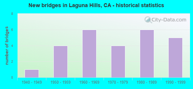
- New bridges - historical statistics
- 11940-1949
- 41950-1959
- 61960-1969
- 41970-1979
- 61980-1989
- 51990-1999

- Reconstructed bridges - Historical Statistics
- 11950-1959
- 11960-1969
- 31970-1979
- 11980-1989
- 31990-1999
- 12000-2009


- Bridge Condition - Deck
- 76.5%Good
- 11.8%Satisfactory
- 11.8%Fair

- Bridge Condition - Superstructure
- 88.2%Good
- 11.8%Fair

- Bridge Condition - Substructure
- 82.4%Good
- 11.8%Satisfactory
- 5.9%Fair

- Bridge Condition - Channel
- 8.3%Excellent
- 91.7%Very good

- Bridge Condition - Culverts
- 33.3%Good
- 66.7%Satisfactory
Find on map >> Show street view
Structure Number: 55 0014, Location: 12-ORA-005-17.75-LGNH (Lat: 33.607081, Lng: -117.694339), Route carried "on" structure: Interstate 5, Year Built: 1959, Year Reconstructed: 1996, Status: Open, Structure Length: 3.72m (12.20ft), Average Daily Traffic: 354,700 (year 2016), Truck Traffic: 6%, Average Future Daily Traffic: 370,321 (year 2041), Design Load: HS 20, Features Intersected: ALISO CREEK
Minimum Vertical Clearance: 30+ m (98+ ft), Kilometerpoint: 17.750, Lanes on structure: 13, Base Highway Network: Yes (, Subroute: 1), Owner: State Highway Agency, Approaching Roadway Width: 62.8m (206.0ft), Skew: 32 degrees, Material/Design: Concrete continuous, Design/Construction: Slab, Number Of Spans In Main Unit: 4, Length of Maximum Span: 9.1m (29.9ft), Curb-To-Curb Width: 62.8m (206.0ft), Out-to-Out Width: 67.9m (222.8ft)
Condition: Deck: Good, Superstructure: Good, Substructure: Good, Channel: Very good, Operating Rating: 54.1 metric tons, Method Used To Determine Operating Rating: Assigned rating based on Load Factor Design (LFD) reported in metric tons, Inventory Rating: 32.4 metric tons, Method Used To Determine Inventory Rating: Assigned rating based on Load Factor Design (LFD) reported in metric tons, Structural Evaluation: Better than present minimum criteria, Deck Geometry: Superior to present desirable criteria, Waterway Adequacy: Equal to present desirable criteria, Approach Roadway Alignment: Equal to present desirable criteria, Designated Inspection Frequency: Every 24 months, Inspection Date: July 2021, Deck Structure Type: Concrete Cast-file-Place
Find on map >> Show street view
Structure Number: 55 0234, Location: 12-ORA-005-16.53-LGNH (Lat: 33.598092, Lng: -117.676158), Route carried "on" structure: Interstate 5, Year Built: 1959, Year Reconstructed: 1996, Status: Open, Structure Length: 3.75m (12.30ft), Average Daily Traffic: 327,000 (year 2019), Truck Traffic: 6%, Average Future Daily Traffic: 343,000 (year 2038), Design Load: HS 20, Features Intersected: LA PAZ RD
Minimum Vertical Clearance: 30+ m (98+ ft), Kilometerpoint: 16.530, Lanes on structure: 10, Lanes under structure: 5, Base Highway Network: Yes (, Subroute: 1), Owner: State Highway Agency, Approaching Roadway Width: 52.4m (171.9ft), Skew: 31 degrees, Material/Design: Concrete continuous, Design/Construction: Tee Beam, Number Of Spans In Main Unit: 3, Length of Maximum Span: 19.8m (65.0ft), Curb-To-Curb Width: 52.4m (171.9ft), Out-to-Out Width: 53.6m (175.9ft)
Condition: Deck: Good, Superstructure: Good, Substructure: Good, Operating Rating: 54.1 metric tons, Method Used To Determine Operating Rating: Assigned rating based on Load Factor Design (LFD) reported in metric tons, Inventory Rating: 32.4 metric tons, Method Used To Determine Inventory Rating: Assigned rating based on Load Factor Design (LFD) reported in metric tons, Structural Evaluation: Better than present minimum criteria, Deck Geometry: Superior to present desirable criteria, Underclear: Meets minimum limits, Approach Roadway Alignment: Better than present minimum criteria, Designated Inspection Frequency: Every 24 months, Inspection Date: July 2021, Deck Structure Type: Concrete Cast-file-Place
Find on map >> Show street view
Structure Number: 55 0235, Location: 12-ORA-005-18.69-LGNH (Lat: 33.614822, Lng: -117.707250), Route carried "on" structure: Interstate 5, Year Built: 1969, Year Reconstructed: 1996, Status: Open, Structure Length: 4.35m (14.27ft), Average Daily Traffic: 388,000 (year 2016), Truck Traffic: 13%, Average Future Daily Traffic: 405,000 (year 2038), Design Load: HS 20+Mod, Features Intersected: EL TORO ROAD
Minimum Vertical Clearance: 30+ m (98+ ft), Kilometerpoint: 18.690, Lanes on structure: 14, Lanes under structure: 7, Base Highway Network: Yes (, Subroute: 1), Owner: State Highway Agency, Approaching Roadway Width: 61.0m (200.1ft), Material/Design: Concrete continuous, Design/Construction: Box Beam or Girders - Multiple, Number Of Spans In Main Unit: 2, Length of Maximum Span: 21.6m (70.9ft), Curb-To-Curb Width: 61.0m (200.1ft), Out-to-Out Width: 66.1m (216.9ft)
Condition: Deck: Good, Superstructure: Good, Substructure: Good, Operating Rating: 54.1 metric tons, Method Used To Determine Operating Rating: Assigned rating based on Load Factor Design (LFD) reported in metric tons, Inventory Rating: 32.4 metric tons, Method Used To Determine Inventory Rating: Assigned rating based on Load Factor Design (LFD) reported in metric tons, Structural Evaluation: Better than present minimum criteria, Deck Geometry: Superior to present desirable criteria, Underclear: Meets minimum limits, Approach Roadway Alignment: Superior to present desirable criteria, Designated Inspection Frequency: Every 24 months, Inspection Date: July 2021, Deck Structure Type: Concrete Cast-file-Place, Wearing Surface/Protective System: Wearing Surface: Integral Concrete
Find on map >> Show street view
Structure Number: 55 0631, Location: 12-ORA-005-17.94-LGNH (Lat: 33.607814, Lng: -117.697686), Route carried "on" structure: City street , Year Built: 1984, Status: Open, Structure Length: 7.59m (24.90ft), Average Daily Traffic: 25,000 (year 2018), Truck Traffic: 3%, Average Future Daily Traffic: 26,123 (year 2038), Design Load: HS 20, Features Intersected: INTERSTATE 5, Facility Carried by Structure: LOS ALISOS BLVD
Minimum Vertical Clearance: 30+ m (98+ ft), Kilometerpoint: 0.000, Lanes on structure: 4, Lanes under structure: 14, Owner: State Highway Agency, Approaching Roadway Width: 23.1m (75.8ft), Skew: 20 degrees, Material/Design: Prestressed concrete continuous, Design/Construction: Box Beam or Girders - Multiple, Number Of Spans In Main Unit: 2, Length of Maximum Span: 37.8m (124.0ft), Curb or Sidewalk Widths: Left: 1.5m (4.9ft), Right: 1.5m (4.9ft), Curb-To-Curb Width: 23.1m (75.8ft), Out-to-Out Width: 26.8m (87.9ft)
Condition: Deck: Fair, Superstructure: Fair, Substructure: Good, Operating Rating: 54.1 metric tons, Method Used To Determine Operating Rating: Assigned rating based on Load Factor Design (LFD) reported in metric tons, Inventory Rating: 32.4 metric tons, Method Used To Determine Inventory Rating: Assigned rating based on Load Factor Design (LFD) reported in metric tons, Structural Evaluation: Somewhat better than minimum adequacy, Deck Geometry: Superior to present desirable criteria, Underclear: Meets minimum limits, Approach Roadway Alignment: Meets minimum limits, Designated Inspection Frequency: Every 24 months, Inspection Date: July 2021, Deck Structure Type: Concrete Cast-file-Place
Find on map >> Show street view
Structure Number: 55 0740S, Location: 12-ORA-005-21.60-IRVN (Lat: 33.645997, Lng: -117.738444), Route carried "on" structure: Ramp Interstate 5, Year Built: 1996, Status: Open, Structure Length: 11.66m (38.25ft), Average Daily Traffic: 1,550 (year 2019), Truck Traffic: 4%, Average Future Daily Traffic: 1,787 (year 2038), Design Load: HS 20+Mod, Features Intersected: BAKE PKWY-N405 ON-RAMP
Minimum Vertical Clearance: 30+ m (98+ ft), Kilometerpoint: 21.600, Lanes on structure: 1, Lanes under structure: 2, Base Highway Network: Yes (, Subroute: 1), Owner: State Highway Agency, Approaching Roadway Width: 7.3m (24.0ft), Material/Design: Prestressed concrete continuous, Design/Construction: Box Beam or Girders - Multiple, Number Of Spans In Main Unit: 3, Length of Maximum Span: 61.0m (200.1ft), Curb-To-Curb Width: 7.3m (24.0ft), Out-to-Out Width: 8.4m (27.6ft)
Condition: Deck: Fair, Superstructure: Good, Substructure: Good, Operating Rating: 54.1 metric tons, Method Used To Determine Operating Rating: Assigned rating based on Load Factor Design (LFD) reported in metric tons, Inventory Rating: 32.4 metric tons, Method Used To Determine Inventory Rating: Assigned rating based on Load Factor Design (LFD) reported in metric tons, Structural Evaluation: Better than present minimum criteria, Deck Geometry: Better than present minimum criteria, Underclear: Superior to present desirable criteria, Approach Roadway Alignment: Equal to present desirable criteria, Designated Inspection Frequency: Every 24 months, Inspection Date: August 2021, Deck Structure Type: Concrete Cast-file-Place
Find on map >> Show street view
Structure Number: 55 0749L, Location: 12-ORA-073-11.76-LGNH (Lat: 33.557969, Lng: -117.685414), Route carried "on" structure: State highway 73, Year Built: 1996, Status: Open, Structure Length: 5.26m (17.26ft), Average Daily Traffic: 25,000 (year 2010), Truck Traffic: 8%, Average Future Daily Traffic: 25,900 (year 2040), Design Load: HS 20+Mod, Features Intersected: GREENFIELD DRIVE
Minimum Vertical Clearance: 30+ m (98+ ft), Kilometerpoint: 11.760, Lanes on structure: 3, Lanes under structure: 6, Base Highway Network: Yes (, Subroute: 1), Toll: On toll road, Owner: State Highway Agency, Approaching Roadway Width: 17.1m (56.1ft), Material/Design: Prestressed concrete, Design/Construction: Box Beam or Girders - Multiple, Number Of Spans In Main Unit: 1, Length of Maximum Span: 51.8m (169.9ft), Curb-To-Curb Width: 17.1m (56.1ft), Out-to-Out Width: 18.1m (59.4ft)
Condition: Deck: Good, Superstructure: Good, Substructure: Good, Operating Rating: 54.1 metric tons, Method Used To Determine Operating Rating: Assigned rating based on Load Factor Design (LFD) reported in metric tons, Inventory Rating: 32.4 metric tons, Method Used To Determine Inventory Rating: Assigned rating based on Load Factor Design (LFD) reported in metric tons, Structural Evaluation: Better than present minimum criteria, Deck Geometry: Equal to present minimum criteria, Underclear: Meets minimum limits, Approach Roadway Alignment: Equal to present desirable criteria, Designated Inspection Frequency: Every 24 months, Inspection Date: June 2020, Deck Structure Type: Concrete Cast-file-Place
Find on map >> Show street view
Structure Number: 55 0749R, Location: 12-ORA-073-11.76-LGNH (Lat: 33.558303, Lng: -117.685333), Route carried "on" structure: State highway 73, Year Built: 1996, Status: Open, Structure Length: 5.26m (17.26ft), Average Daily Traffic: 25,000 (year 2010), Truck Traffic: 8%, Average Future Daily Traffic: 25,900 (year 2040), Design Load: HS 20+Mod, Features Intersected: GREENFIELD DRIVE
Minimum Vertical Clearance: 30+ m (98+ ft), Kilometerpoint: 11.760, Lanes on structure: 3, Lanes under structure: 6, Base Highway Network: Yes (, Subroute: 1), Toll: On toll road, Owner: State Highway Agency, Approaching Roadway Width: 17.1m (56.1ft), Material/Design: Prestressed concrete, Design/Construction: Box Beam or Girders - Multiple, Number Of Spans In Main Unit: 1, Length of Maximum Span: 51.8m (169.9ft), Curb-To-Curb Width: 17.1m (56.1ft), Out-to-Out Width: 18.1m (59.4ft)
Condition: Deck: Good, Superstructure: Good, Substructure: Good, Operating Rating: 54.1 metric tons, Method Used To Determine Operating Rating: Assigned rating based on Load Factor Design (LFD) reported in metric tons, Inventory Rating: 32.4 metric tons, Method Used To Determine Inventory Rating: Assigned rating based on Load Factor Design (LFD) reported in metric tons, Structural Evaluation: Better than present minimum criteria, Deck Geometry: Equal to present minimum criteria, Underclear: Meets minimum limits, Approach Roadway Alignment: Equal to present desirable criteria, Designated Inspection Frequency: Every 24 months, Inspection Date: June 2020, Deck Structure Type: Concrete Cast-file-Place
Find on map >> Show street view
Structure Number: 55 1136, Location: 12-ORA-005-16.32-LGNH (Lat: 33.596361, Lng: -117.673972), Route carried "on" structure: Interstate 5, Year Built: 1959, Year Reconstructed: 1969, Status: Open, Structure Length: 2.74m (8.99ft), Average Daily Traffic: 269,000 (year 2011), Truck Traffic: 4%, Average Future Daily Traffic: 320,000 (year 2038), Features Intersected: EL TORO DRAIN
Minimum Vertical Clearance: 30+ m (98+ ft), Kilometerpoint: 16.320, Lanes on structure: 12, Base Highway Network: Yes (, Subroute: 1), Owner: State Highway Agency, Approaching Roadway Width: 56.0m (183.7ft), Skew: 9 degrees, Material/Design: Concrete continuous, Design/Construction: Culvert, Number Of Spans In Main Unit: 6, Length of Maximum Span: 4.6m (15.1ft)
Condition: Channel: Very good, Culverts: Satisfactory, Structural Evaluation: Equal to present minimum criteria, Waterway Adequacy: Equal to present desirable criteria, Approach Roadway Alignment: Equal to present desirable criteria, Designated Inspection Frequency: Every 24 months, Inspection Date: July 2021
Find on map >> Show street view
Structure Number: 55C0056, Location: 0.1 MI WEST OF ROUTE I-5 (Lat: 33.580011, Lng: -117.673633), Route carried "on" structure: City street , Year Built: 1971, Year Reconstructed: 2012, Status: Open, Structure Length: 7.25m (23.79ft), Average Daily Traffic: 40,800 (year 2019), Truck Traffic: 1%, Average Future Daily Traffic: 79,890 (year 2038), Design Load: HS 20+Mod, Features Intersected: BNSF RY,AMTRAK,METROLINK, Facility Carried by Structure: OSO PARKWAY
Minimum Vertical Clearance: 30+ m (98+ ft), Kilometerpoint: 0.000, Lanes on structure: 8, Base Highway Network: Yes, Owner: City or Municipal Highway Agency, Approaching Roadway Width: 43.2m (141.7ft), Skew: 9 degrees, Material/Design: Prestressed concrete continuous, Design/Construction: Box Beam or Girders - Multiple, Number Of Spans In Main Unit: 2, Length of Maximum Span: 37.8m (124.0ft), Curb or Sidewalk Widths: Left: 1.5m (4.9ft), Right: 0.0m, Curb-To-Curb Width: 43.2m (141.7ft), Out-to-Out Width: 45.4m (149.0ft)
Condition: Deck: Good, Superstructure: Good, Substructure: Good, Channel: Excellent, Operating Rating: 94.6 metric tons, Method Used To Determine Operating Rating: Load Factor (LF), Inventory Rating: 32.4 metric tons, Method Used To Determine Inventory Rating: Load Factor (LF), Structural Evaluation: Better than present minimum criteria, Deck Geometry: Superior to present desirable criteria, Underclear: Better than present minimum criteria, Waterway Adequacy: Superior to present desirable criteria, Approach Roadway Alignment: Equal to present desirable criteria, Designated Inspection Frequency: Every 24 months, Inspection Date: May 2021, Deck Structure Type: Concrete Cast-file-Place
Find on map >> Show street view
Structure Number: 55C0191, Location: 0.2 MI S OF LAKE FOREST (Lat: 33.627903, Lng: -117.739764), Route carried "on" structure: City street , Year Built: 1976, Status: Open, Structure Length: 3.26m (10.70ft), Average Daily Traffic: 4,400 (year 2019), Truck Traffic: 1%, Average Future Daily Traffic: 8,410 (year 2038), Features Intersected: CANADA CHANNEL, Facility Carried by Structure: SANTA VITTORIA DR
Minimum Vertical Clearance: 30+ m (98+ ft), Kilometerpoint: 0.000, Lanes on structure: 2, Owner: City or Municipal Highway Agency, Approaching Roadway Width: 12.2m (40.0ft), Skew: 1 degrees, Material/Design: Concrete continuous, Design/Construction: Slab, Number Of Spans In Main Unit: 4, Length of Maximum Span: 7.9m (25.9ft), Curb or Sidewalk Widths: Left: 1.5m (4.9ft), Right: 1.5m (4.9ft), Curb-To-Curb Width: 12.2m (40.0ft), Out-to-Out Width: 15.9m (52.2ft)
Condition: Deck: Good, Superstructure: Fair, Substructure: Good, Channel: Very good, Operating Rating: 54.1 metric tons, Method Used To Determine Operating Rating: Field evaluation and documented engineering judgment, Inventory Rating: 32.4 metric tons, Method Used To Determine Inventory Rating: Field evaluation and documented engineering judgment, Structural Evaluation: Somewhat better than minimum adequacy, Deck Geometry: Equal to present minimum criteria, Waterway Adequacy: Superior to present desirable criteria, Approach Roadway Alignment: Equal to present minimum criteria, Designated Inspection Frequency: Every 24 months, Inspection Date: May 2021, Deck Structure Type: Concrete Cast-file-Place
Find on map >> Show street view
Structure Number: 55C0221L, Location: 1.5 MI S EL TORO RD (Lat: 33.589375, Lng: -117.711669), Route carried "on" structure: City street , Year Built: 1987, Status: Open, Structure Length: 6.10m (20.01ft), Average Daily Traffic: 11,000 (year 2011), Truck Traffic: 1%, Average Future Daily Traffic: 26,696 (year 2043), Design Load: HS 20+Mod, Features Intersected: ALISO CREEK, Facility Carried by Structure: S/B MOULTON PKWY
Minimum Vertical Clearance: 30+ m (98+ ft), Kilometerpoint: 0.000, Lanes on structure: 3, Base Highway Network: Yes, Owner: City or Municipal Highway Agency, Approaching Roadway Width: 13.4m (44.0ft), Skew: 6 degrees, Material/Design: Prestressed concrete continuous, Design/Construction: Box Beam or Girders - Multiple, Number Of Spans In Main Unit: 2, Length of Maximum Span: 29.3m (96.1ft), Curb or Sidewalk Widths: Left: 1.5m (4.9ft), Right: 0.0m, Curb-To-Curb Width: 13.4m (44.0ft), Out-to-Out Width: 15.8m (51.8ft)
Condition: Deck: Good, Superstructure: Good, Substructure: Good, Channel: Very good, Operating Rating: 54.1 metric tons, Method Used To Determine Operating Rating: Assigned rating based on Load Factor Design (LFD) reported in metric tons, Inventory Rating: 32.4 metric tons, Method Used To Determine Inventory Rating: Assigned rating based on Load Factor Design (LFD) reported in metric tons, Structural Evaluation: Better than present minimum criteria, Deck Geometry: Somewhat better than minimum adequacy, Waterway Adequacy: Equal to present desirable criteria, Approach Roadway Alignment: Equal to present desirable criteria, Designated Inspection Frequency: Every 48 months, Inspection Date: May 2021, Deck Structure Type: Concrete Cast-file-Place
Find on map >> Show street view
Structure Number: 55C0221R, Location: 1.5 MI S EL TORO RD (Lat: 33.589828, Lng: -117.711672), Route carried "on" structure: City street , Year Built: 1969, Year Reconstructed: 1983, Status: Open, Structure Length: 5.73m (18.80ft), Average Daily Traffic: 11,000 (year 2019), Truck Traffic: 1%, Average Future Daily Traffic: 25,312 (year 2038), Design Load: HS 20, Features Intersected: ALISO CREEK, Facility Carried by Structure: N/B MOULTON PKWY
Minimum Vertical Clearance: 30+ m (98+ ft), Kilometerpoint: 0.000, Lanes on structure: 3, Base Highway Network: Yes, Owner: City or Municipal Highway Agency, Approaching Roadway Width: 13.4m (44.0ft), Skew: 6 degrees, Material/Design: Concrete continuous, Design/Construction: Tee Beam, Number Of Spans In Main Unit: 4, Length of Maximum Span: 15.8m (51.8ft), Curb or Sidewalk Widths: Left: 0.3m (1.0ft), Right: 1.5m (4.9ft), Curb-To-Curb Width: 13.4m (44.0ft), Out-to-Out Width: 15.9m (52.2ft)
Condition: Deck: Good, Superstructure: Good, Substructure: Good, Channel: Very good, Operating Rating: 30.8 metric tons, Method Used To Determine Operating Rating: Load and Resistance Factor Rating (LRFR) rating reported by rating factor(RF) method using HL-93 loadings, Inventory Rating: 21.4 metric tons, Method Used To Determine Inventory Rating: Load and Resistance Factor Rating (LRFR) rating reported by rating factor(RF) method using HL-93 loadings, Structural Evaluation: Somewhat better than minimum adequacy, Deck Geometry: Somewhat better than minimum adequacy, Waterway Adequacy: Superior to present desirable criteria, Approach Roadway Alignment: Equal to present desirable criteria, Designated Inspection Frequency: Every 24 months, Inspection Date: May 2021, Deck Structure Type: Concrete Cast-file-Place, Wearing Surface/Protective System: Wearing Surface: Monolithic Concrete
Find on map >> Show street view
Structure Number: 55C023, Location: 50' E/O HARBOR BLVD (Lat: 33.881139, Lng: -117.924372), Route carried "on" structure: City street , Year Built: 1940, Year Reconstructed: 1964, Status: Open, Structure Length: 1.65m (5.41ft), Average Daily Traffic: 2,000 (year 2018), Truck Traffic: 1%, Average Future Daily Traffic: 4,303 (year 2042), Features Intersected: BREA CREEK CHANNEL, Facility Carried by Structure: VALLEY VIEW DR
Minimum Vertical Clearance: 30+ m (98+ ft), Kilometerpoint: 0.000, Lanes on structure: 3, Owner: City or Municipal Highway Agency, Approaching Roadway Width: 12.0m (39.4ft), Material/Design: Concrete, Design/Construction: Tee Beam, Number Of Spans In Main Unit: 1, Number Of Approach Spans: 1, Length of Maximum Span: 13.7m (44.9ft), Curb or Sidewalk Widths: Left: 1.5m (4.9ft), Right: 1.5m (4.9ft), Curb-To-Curb Width: 12.0m (39.4ft), Out-to-Out Width: 15.8m (51.8ft)
Condition: Deck: Good, Superstructure: Good, Substructure: Good, Channel: Very good, Operating Rating: 25.9 metric tons, Method Used To Determine Operating Rating: Field evaluation and documented engineering judgment, Inventory Rating: 15.6 metric tons, Method Used To Determine Inventory Rating: Field evaluation and documented engineering judgment, Structural Evaluation: Meets minimum limits, Deck Geometry: Meets minimum limits, Waterway Adequacy: Superior to present desirable criteria, Approach Roadway Alignment: Equal to present desirable criteria, Designated Inspection Frequency: Every 24 months, Inspection Date: Febuary 2022, Deck Structure Type: Concrete Cast-file-Place, Wearing Surface/Protective System: Wearing Surface: Bituminous
Find on map >> Show street view
Structure Number: 55C0237, Location: 200' NW ALICIA PKWAY (Lat: 33.584256, Lng: -117.707217), Route carried "on" structure: City street , Year Built: 1968, Year Reconstructed: 1981, Status: Open, Structure Length: 0.70m (2.30ft), Average Daily Traffic: 20,900 (year 2019), Truck Traffic: 1%, Average Future Daily Traffic: 44,445 (year 2038), Design Load: HS 20, Features Intersected: ALICIA CREEK, Facility Carried by Structure: MOULTON PARKWAY
Minimum Vertical Clearance: 30+ m (98+ ft), Kilometerpoint: 0.000, Lanes on structure: 9, Base Highway Network: Yes, Owner: City or Municipal Highway Agency, Approaching Roadway Width: 33.8m (110.9ft), Skew: 32 degrees, Material/Design: Concrete, Design/Construction: Culvert, Number Of Spans In Main Unit: 1, Length of Maximum Span: 6.8m (22.3ft), Curb or Sidewalk Widths: Left: 2.1m (6.9ft), Right: 3.2m (10.5ft), Curb-To-Curb Width: 33.8m (110.9ft), Out-to-Out Width: 43.0m (141.1ft)
Condition: Channel: Very good, Culverts: Good, Operating Rating: 40.5 metric tons, Method Used To Determine Operating Rating: Field evaluation and documented engineering judgment, Inventory Rating: 24.3 metric tons, Method Used To Determine Inventory Rating: Field evaluation and documented engineering judgment, Structural Evaluation: Equal to present minimum criteria, Deck Geometry: Somewhat better than minimum adequacy, Waterway Adequacy: Superior to present desirable criteria, Approach Roadway Alignment: Equal to present desirable criteria, Designated Inspection Frequency: Every 24 months, Inspection Date: May 2021
Find on map >> Show street view
Structure Number: 55C0238, Location: 200' N OF LA PAZ RD (Lat: 33.576617, Lng: -117.702267), Route carried "on" structure: City street , Year Built: 1968, Year Reconstructed: 1980, Status: Open, Structure Length: 0.70m (2.30ft), Average Daily Traffic: 21,000 (year 2019), Truck Traffic: 1%, Average Future Daily Traffic: 44,445 (year 2038), Design Load: HS 20, Features Intersected: PEDESTRIAN & BIKE ACCESS, Facility Carried by Structure: MOULTON PARKWAY
Minimum Vertical Clearance: 30+ m (98+ ft), Kilometerpoint: 0.000, Lanes on structure: 9, Base Highway Network: Yes, Owner: City or Municipal Highway Agency, Approaching Roadway Width: 29.9m (98.1ft), Skew: 30 degrees, Material/Design: Concrete, Design/Construction: Slab, Number Of Spans In Main Unit: 1, Length of Maximum Span: 6.4m (21.0ft), Curb or Sidewalk Widths: Left: 3.0m (9.8ft), Right: 1.5m (4.9ft), Curb-To-Curb Width: 33.0m (108.3ft), Out-to-Out Width: 47.0m (154.2ft)
Condition: Deck: Good, Superstructure: Good, Substructure: Fair, Operating Rating: 40.5 metric tons, Method Used To Determine Operating Rating: Load and Resistance Factor Rating (LRFR) rating reported by rating factor(RF) method using HL-93 loadings, Inventory Rating: 24.3 metric tons, Method Used To Determine Inventory Rating: Load and Resistance Factor Rating (LRFR) rating reported by rating factor(RF) method using HL-93 loadings, Structural Evaluation: Somewhat better than minimum adequacy, Deck Geometry: Meets minimum limits, Approach Roadway Alignment: Equal to present desirable criteria, Designated Inspection Frequency: Every 24 months, Inspection Date: June 2021, Deck Structure Type: Concrete Cast-file-Place, Wearing Surface/Protective System: Wearing Surface: Bituminous
Find on map >> Show street view
Structure Number: 55C0239, Location: 0.2 MI NE OF MOULTON PWY (Lat: 33.577506, Lng: -117.698319), Route carried "on" structure: City street , Year Built: 1968, Year Reconstructed: 1984, Status: Open, Structure Length: 0.70m (2.30ft), Average Daily Traffic: 16,000 (year 2019), Truck Traffic: 1%, Average Future Daily Traffic: 33,638 (year 2038), Features Intersected: LA PAZ EQUIP UC, Facility Carried by Structure: LA PAZ RD
Minimum Vertical Clearance: 30+ m (98+ ft), Kilometerpoint: 0.000, Lanes on structure: 4, Owner: City or Municipal Highway Agency, Approaching Roadway Width: 25.6m (84.0ft), Material/Design: Concrete, Design/Construction: Slab, Number Of Spans In Main Unit: 1, Length of Maximum Span: 6.4m (21.0ft), Curb or Sidewalk Widths: Left: 2.4m (7.9ft), Right: 2.5m (8.2ft), Curb-To-Curb Width: 25.6m (84.0ft), Out-to-Out Width: 35.4m (116.1ft)
Condition: Deck: Good, Superstructure: Good, Substructure: Good, Operating Rating: 40.5 metric tons, Method Used To Determine Operating Rating: Load and Resistance Factor Rating (LRFR) rating reported by rating factor(RF) method using HL-93 loadings, Inventory Rating: 24.3 metric tons, Method Used To Determine Inventory Rating: Load and Resistance Factor Rating (LRFR) rating reported by rating factor(RF) method using HL-93 loadings, Structural Evaluation: Equal to present minimum criteria, Deck Geometry: Superior to present desirable criteria, Approach Roadway Alignment: Equal to present desirable criteria, Designated Inspection Frequency: Every 24 months, Inspection Date: June 2021, Deck Structure Type: Concrete Cast-file-Place, Wearing Surface/Protective System: Wearing Surface: Bituminous
Find on map >> Show street view
Structure Number: 55C0495, Location: 0.1 MI S/O OSO PARKWAY (Lat: 33.573719, Lng: -117.690311), Route carried "on" structure: City street , Year Built: 1979, Status: Open, Structure Length: 0.79m (2.59ft), Average Daily Traffic: 2,700 (year 2019), Truck Traffic: 1%, Average Future Daily Traffic: 4,204 (year 2038), Features Intersected: NARCO CHANNEL, Facility Carried by Structure: NELLIE GAIL ROAD
Minimum Vertical Clearance: 30+ m (98+ ft), Kilometerpoint: 0.000, Lanes on structure: 2, Owner: City or Municipal Highway Agency, Approaching Roadway Width: 15.2m (49.9ft), Skew: 31 degrees, Material/Design: Steel, Design/Construction: Culvert, Number Of Spans In Main Unit: 1, Length of Maximum Span: 7.6m (24.9ft), Curb or Sidewalk Widths: Left: 1.5m (4.9ft), Right: 1.5m (4.9ft), Curb-To-Curb Width: 15.2m (49.9ft), Out-to-Out Width: 45.4m (149.0ft)
Condition: Channel: Very good, Culverts: Satisfactory, Operating Rating: 54.1 metric tons, Method Used To Determine Operating Rating: Field evaluation and documented engineering judgment, Inventory Rating: 32.4 metric tons, Method Used To Determine Inventory Rating: Field evaluation and documented engineering judgment, Structural Evaluation: Equal to present minimum criteria, Deck Geometry: Superior to present desirable criteria, Waterway Adequacy: Equal to present desirable criteria, Approach Roadway Alignment: Equal to present minimum criteria, Designated Inspection Frequency: Every 24 months, Inspection Date: June 2021
Find on map >> Show street view
Structure Number: 55C0529L, Location: 400' E/O MOULTON PKWY (Lat: 33.592086, Lng: -117.711789), Route carried "on" structure: City street , Year Built: 1985, Status: Open, Structure Length: 5.73m (18.80ft), Average Daily Traffic: 3,618 (year 2019), Truck Traffic: 1%, Average Future Daily Traffic: 11,222 (year 2037), Design Load: HS 20, Features Intersected: ALISO CREEK, Facility Carried by Structure: W/B LGNA HILLS DR
Minimum Vertical Clearance: 30+ m (98+ ft), Kilometerpoint: 0.000, Lanes on structure: 3, Owner: City or Municipal Highway Agency, Approaching Roadway Width: 9.8m (32.2ft), Skew: 2 degrees, Material/Design: Prestressed concrete continuous, Design/Construction: Box Beam or Girders - Multiple, Number Of Spans In Main Unit: 3, Length of Maximum Span: 24.1m (79.1ft), Curb or Sidewalk Widths: Left: 0.3m (1.0ft), Right: 1.5m (4.9ft), Curb-To-Curb Width: 9.8m (32.2ft), Out-to-Out Width: 12.2m (40.0ft)
Condition: Deck: Satisfactory, Superstructure: Good, Substructure: Good, Channel: Very good, Operating Rating: 82.9 metric tons, Method Used To Determine Operating Rating: Load Factor (LF), Inventory Rating: 32.4 metric tons, Method Used To Determine Inventory Rating: Load Factor (LF), Structural Evaluation: Better than present minimum criteria, Deck Geometry: High priority of replacement, Waterway Adequacy: Superior to present desirable criteria, Approach Roadway Alignment: Equal to present desirable criteria, Designated Inspection Frequency: Every 48 months, Inspection Date: June 2019, Deck Structure Type: Concrete Cast-file-Place, Wearing Surface/Protective System: Wearing Surface: Monolithic Concrete
Find on map >> Show street view
Structure Number: 55C0529R, Location: 400' E/O MOULTON PKWY (Lat: 33.591894, Lng: -117.711839), Route carried "on" structure: City street , Year Built: 1985, Status: Open, Structure Length: 5.91m (19.39ft), Average Daily Traffic: 3,606 (year 2019), Truck Traffic: 1%, Average Future Daily Traffic: 11,259 (year 2037), Design Load: HS 20, Features Intersected: ALISO CREEK, Facility Carried by Structure: E/B LGNA HILLS DR
Minimum Vertical Clearance: 30+ m (98+ ft), Kilometerpoint: 0.000, Lanes on structure: 2, Owner: City or Municipal Highway Agency, Approaching Roadway Width: 10.7m (35.1ft), Skew: 2 degrees, Material/Design: Prestressed concrete continuous, Design/Construction: Box Beam or Girders - Multiple, Number Of Spans In Main Unit: 3, Length of Maximum Span: 24.1m (79.1ft), Curb or Sidewalk Widths: Left: 1.5m (4.9ft), Right: 0.3m (1.0ft), Curb-To-Curb Width: 10.7m (35.1ft), Out-to-Out Width: 13.1m (43.0ft)
Condition: Deck: Good, Superstructure: Good, Substructure: Satisfactory, Channel: Very good, Operating Rating: 99.8 metric tons, Method Used To Determine Operating Rating: Load Factor (LF), Inventory Rating: 32.4 metric tons, Method Used To Determine Inventory Rating: Load Factor (LF), Structural Evaluation: Equal to present minimum criteria, Deck Geometry: Somewhat better than minimum adequacy, Waterway Adequacy: Equal to present desirable criteria, Approach Roadway Alignment: Equal to present desirable criteria, Designated Inspection Frequency: Every 48 months, Inspection Date: June 2019, Deck Structure Type: Concrete Cast-file-Place, Wearing Surface/Protective System: Wearing Surface: Monolithic Concrete
Find on map >> Show street view
Structure Number: 55C0549, Location: 0.2 MI S LAKE FOREST DR (Lat: 33.627192, Lng: -117.735275), Route carried "on" structure: Federal lands road , Year Built: 1980, Status: Open, Structure Length: 2.71m (8.89ft), Average Daily Traffic: 2,000 (year 2019), Truck Traffic: 1%, Average Future Daily Traffic: 6,307 (year 2037), Design Load: HS 20, Features Intersected: CANADA CHANNEL, Facility Carried by Structure: MILL CREEK DRIVE
Minimum Vertical Clearance: 30+ m (98+ ft), Kilometerpoint: 0.000, Lanes on structure: 2, Owner: City or Municipal Highway Agency, Approaching Roadway Width: 13.4m (44.0ft), Material/Design: Concrete continuous, Design/Construction: Slab, Number Of Spans In Main Unit: 3, Length of Maximum Span: 8.8m (28.9ft), Curb or Sidewalk Widths: Left: 2.1m (6.9ft), Right: 2.1m (6.9ft), Curb-To-Curb Width: 13.4m (44.0ft), Out-to-Out Width: 18.3m (60.0ft)
Condition: Deck: Satisfactory, Superstructure: Good, Substructure: Satisfactory, Channel: Very good, Operating Rating: 92.7 metric tons, Method Used To Determine Operating Rating: Load Factor (LF), Inventory Rating: 55.7 metric tons, Method Used To Determine Inventory Rating: Load Factor (LF), Structural Evaluation: Equal to present minimum criteria, Deck Geometry: Equal to present desirable criteria, Waterway Adequacy: Superior to present desirable criteria, Approach Roadway Alignment: Equal to present minimum criteria, Designated Inspection Frequency: Every 48 months, Inspection Date: June 2019, Deck Structure Type: Concrete Cast-file-Place
Find on map >> Show street view
Structure Number: 55 0234, Location: 12-ORA-005-16.53-LGNH (Lat: 33.598092, Lng: -117.676158), Route carried "under" structure: County highway M236, Year Built: 1959, Structure Length: 0. m, Average Daily Traffic: 38,000 (year 2019), Truck Traffic: 3%, Features Intersected: LA PAZ RD, Facility Carried by Structure: INTERSTATE 5
Minimum Vertical Clearance: 4.49m (14.73ft), Kilometerpoint: 0.000, Lanes on structure: 10, Lanes under structure: 5, Material/Design: Concrete continuous, Design/Construction: Tee Beam, Length of Maximum Span: 19.8m (65.0ft)
Find on map >> Show street view
Structure Number: 55 0235, Location: 12-ORA-005-18.69-LGNH (Lat: 33.614822, Lng: -117.707250), Route carried "under" structure: County highway M228, Year Built: 1969, Structure Length: 0. m, Average Daily Traffic: 54,000 (year 2018), Truck Traffic: 3%, Features Intersected: EL TORO ROAD, Facility Carried by Structure: INTERSTATE 5
Minimum Vertical Clearance: 4.62m (15.16ft), Kilometerpoint: 0.000, Lanes on structure: 14, Lanes under structure: 7, Material/Design: Concrete continuous, Design/Construction: Box Beam or Girders - Multiple, Length of Maximum Span: 21.6m (70.9ft)
Find on map >> Show street view
Structure Number: 55 0591, Location: 12-ORA-005-17.47-LGNH (Lat: 33.604058, Lng: -117.690467), Route carried "under" structure: Interstate 5, Year Built: 1974, Structure Length: 0. m, Average Daily Traffic: 285,000 (year 2020), Truck Traffic: 7%, Features Intersected: INTERSTATE 5, Facility Carried by Structure: ALICIA PARKWAY
Minimum Vertical Clearance: 5.51m (18.08ft), Kilometerpoint: 17.470, Lanes on structure: 8, Lanes under structure: 13, Material/Design: Prestressed concrete continuous, Design/Construction: Box Beam or Girders - Multiple, Length of Maximum Span: 49.7m (163.1ft)
Find on map >> Show street view
Structure Number: 55 0631, Location: 12-ORA-005-17.94-LGNH (Lat: 33.607814, Lng: -117.697686), Route carried "under" structure: Interstate 5, Year Built: 1984, Structure Length: 0. m, Average Daily Traffic: 285,000 (year 2020), Truck Traffic: 7%, Features Intersected: INTERSTATE 5, Facility Carried by Structure: LOS ALISOS BLVD
Minimum Vertical Clearance: 5.56m (18.24ft), Kilometerpoint: 17.940, Lanes on structure: 4, Lanes under structure: 14, Material/Design: Prestressed concrete continuous, Design/Construction: Box Beam or Girders - Multiple, Length of Maximum Span: 37.8m (124.0ft)
Find on map >> Show street view
Structure Number: 55 0749L, Location: 12-ORA-073-11.76-LGNH (Lat: 33.557969, Lng: -117.685414), Route carried "under" structure: City street , Year Built: 1996, Structure Length: 0. m, Average Daily Traffic: 10,000 (year 2010), Truck Traffic: 3%, Features Intersected: GREENFIELD DRIVE, Facility Carried by Structure: SR 73 SB
Minimum Vertical Clearance: 5.51m (18.08ft), Kilometerpoint: 0.000, Lanes on structure: 3, Lanes under structure: 6, Material/Design: Prestressed concrete, Design/Construction: Box Beam or Girders - Multiple, Length of Maximum Span: 51.8m (169.9ft)
Find on map >> Show street view
Structure Number: 55 0749R, Location: 12-ORA-073-11.76-LGNH (Lat: 33.558303, Lng: -117.685333), Route carried "under" structure: City street , Year Built: 1996, Structure Length: 0. m, Average Daily Traffic: 10,000 (year 2010), Truck Traffic: 2%, Features Intersected: GREENFIELD DRIVE, Facility Carried by Structure: SR 73 NB
Minimum Vertical Clearance: 5.05m (16.57ft), Kilometerpoint: 0.000, Lanes on structure: 3, Lanes under structure: 6, Material/Design: Prestressed concrete, Design/Construction: Box Beam or Girders - Multiple, Length of Maximum Span: 51.8m (169.9ft)