Bridge Statistics for Lake City, Arkansas (AR)
Condition, Traffic, Stress, Structural Evaluation, Project Costs
- National Bridge Inventory (NBI) Statistics
- 19Number of bridges
- 495ft / 151mTotal length
- 59,261Total average daily traffic
- 7,465Total average daily truck traffic
- 63,942Total future (year 2007) average daily traffic
- National Bridge Inventory (NBI) Registered Bridges for Lake City
- No street view available for this location
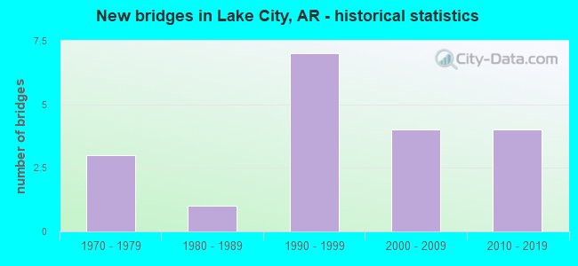
- New bridges - historical statistics
- 31970-1979
- 11980-1989
- 71990-1999
- 42000-2009
- 42010-2019


- Bridge Condition - Deck
- 11.8%Very good
- 76.5%Good
- 5.9%Satisfactory
- 5.9%Fair

- Bridge Condition - Superstructure
- 5.9%Very good
- 52.9%Good
- 41.2%Satisfactory

- Bridge Condition - Substructure
- 17.6%Very good
- 70.6%Good
- 11.8%Satisfactory

- Bridge Condition - Channel
- 73.7%Good
- 21.1%Satisfactory
- 5.3%Fair

- Bridge Condition - Culverts
- 50.0%Good
- 50.0%Satisfactory
Find on map >> Show street view
Structure Number: 4657, Location: 1.5 MI WEST LESTER (Lat: 35.877600, Lng: -90.485658), Route carried "on" structure: County highway 60, Year Built: 1991, Status: Open, Structure Length: 4.94m (16.21ft), Average Daily Traffic: 419 (year 2018), Truck Traffic: 1%, Average Future Daily Traffic: 215 (year 2007), Design Load: HS 20, Features Intersected: THOMPSON CREEK DITCH
Minimum Vertical Clearance: 30+ m (98+ ft), Kilometerpoint: 2.865, Lanes on structure: 2, Owner: County Highway Agency, Approaching Roadway Width: 9.8m (32.2ft), Skew: 3 degrees, Material/Design: Steel, Design/Construction: Stringer/Multi-beam, Number Of Spans In Main Unit: 3, Length of Maximum Span: 16.2m (53.1ft), Curb-To-Curb Width: 8.5m (27.9ft), Out-to-Out Width: 9.4m (30.8ft)
Condition: Deck: Very good, Superstructure: Very good, Substructure: Good, Channel: Good, Operating Rating: 54.4 metric tons, Method Used To Determine Operating Rating: Load Factor (LF), Inventory Rating: 32.7 metric tons, Method Used To Determine Inventory Rating: Load Factor (LF), Structural Evaluation: Better than present minimum criteria, Deck Geometry: Somewhat better than minimum adequacy, Waterway Adequacy: Superior to present desirable criteria, Approach Roadway Alignment: Better than present minimum criteria, Designated Inspection Frequency: Every 24 months, Critical Feature Inspection Frequency: Every 24 months, Inspection Date: September 2021, Deck Structure Type: Concrete Cast-file-Place, Wearing Surface/Protective System: Wearing Surface: Monolithic Concrete
Find on map >> Show street view
Structure Number: 5642, Location: 3.32 MI N JCT SH 18 (Lat: 35.869772, Lng: -90.463506), Route carried "on" structure: State highway 135, Year Built: 1977, Status: Open, Structure Length: 4.28m (14.04ft), Average Daily Traffic: 1,250 (year 2018), Truck Traffic: 1%, Average Future Daily Traffic: 1,610 (year 2028), Design Load: HS 20, Features Intersected: THOMPSON CREEK
Minimum Vertical Clearance: 30+ m (98+ ft), Kilometerpoint: 5.343, Lanes on structure: 2, Base Highway Network: Yes, Owner: State Highway Agency, Approaching Roadway Width: 9.8m (32.2ft), Skew: 2 degrees, Material/Design: Steel, Design/Construction: Stringer/Multi-beam, Number Of Spans In Main Unit: 3, Length of Maximum Span: 14.0m (45.9ft), Curb-To-Curb Width: 9.1m (29.9ft), Out-to-Out Width: 10.0m (32.8ft)
Condition: Deck: Good, Superstructure: Satisfactory, Substructure: Satisfactory, Channel: Satisfactory, Operating Rating: 54.4 metric tons, Method Used To Determine Operating Rating: Load Factor (LF), Inventory Rating: 32.7 metric tons, Method Used To Determine Inventory Rating: Load Factor (LF), Structural Evaluation: Equal to present minimum criteria, Deck Geometry: Somewhat better than minimum adequacy, Waterway Adequacy: Equal to present desirable criteria, Approach Roadway Alignment: Better than present minimum criteria, Designated Inspection Frequency: Every 24 months, Critical Feature Inspection Frequency: Every 24 months, Inspection Date: October 2020, Deck Structure Type: Concrete Cast-file-Place, Wearing Surface/Protective System: Wearing Surface: Bituminous
Find on map >> Show street view
Structure Number: 5643, Location: 3.36 MI N JCT SH 18 (Lat: 35.870103, Lng: -90.463028), Route carried "on" structure: State highway 135, Year Built: 1977, Status: Open, Structure Length: 4.64m (15.22ft), Average Daily Traffic: 1,250 (year 2018), Truck Traffic: 1%, Average Future Daily Traffic: 1,610 (year 2028), Design Load: HS 20, Features Intersected: BIG BAY DITCH
Minimum Vertical Clearance: 30+ m (98+ ft), Kilometerpoint: 5.407, Lanes on structure: 2, Base Highway Network: Yes, Owner: State Highway Agency, Approaching Roadway Width: 9.8m (32.2ft), Skew: 2 degrees, Material/Design: Steel, Design/Construction: Stringer/Multi-beam, Number Of Spans In Main Unit: 3, Length of Maximum Span: 15.2m (49.9ft), Curb-To-Curb Width: 9.1m (29.9ft), Out-to-Out Width: 10.0m (32.8ft)
Condition: Deck: Good, Superstructure: Satisfactory, Substructure: Good, Channel: Good, Operating Rating: 54.4 metric tons, Method Used To Determine Operating Rating: Load Factor (LF), Inventory Rating: 32.7 metric tons, Method Used To Determine Inventory Rating: Load Factor (LF), Structural Evaluation: Equal to present minimum criteria, Deck Geometry: Somewhat better than minimum adequacy, Waterway Adequacy: Equal to present desirable criteria, Approach Roadway Alignment: Equal to present desirable criteria, Designated Inspection Frequency: Every 24 months, Critical Feature Inspection Frequency: Every 24 months, Inspection Date: October 2020, Deck Structure Type: Concrete Cast-file-Place, Wearing Surface/Protective System: Wearing Surface: Bituminous
Find on map >> Show street view
Structure Number: 6627, Location: EAST EDGE OF LAKE CITY (Lat: 35.820700, Lng: -90.432986), Route carried "on" structure: State highway 18, Year Built: 1998, Status: Open, Structure Length: 105.28m (345.41ft), Average Daily Traffic: 8,160 (year 2018), Truck Traffic: 18%, Average Future Daily Traffic: 9,394 (year 2028), Design Load: HS 20+Mod, Features Intersected: ST FRANCIS RIVER
Minimum Vertical Clearance: 30+ m (98+ ft), Kilometerpoint: 26.409, Lanes on structure: 4, Base Highway Network: Yes, Owner: State Highway Agency, Approaching Roadway Width: 21.3m (69.9ft), Skew: 3 degrees, Material/Design: Steel continuous, Design/Construction: Stringer/Multi-beam, Number Of Spans In Main Unit: 51, Length of Maximum Span: 30.5m (100.1ft), Curb-To-Curb Width: 21.3m (69.9ft), Out-to-Out Width: 22.2m (72.8ft)
Condition: Deck: Good, Superstructure: Good, Substructure: Good, Channel: Good, Operating Rating: 53.5 metric tons, Method Used To Determine Operating Rating: Load Factor (LF), Inventory Rating: 31.8 metric tons, Method Used To Determine Inventory Rating: Load Factor (LF), Structural Evaluation: Better than present minimum criteria, Deck Geometry: Superior to present desirable criteria, Waterway Adequacy: Equal to present desirable criteria, Approach Roadway Alignment: Equal to present desirable criteria, Designated Inspection Frequency: Every 24 months, Critical Feature Inspection Frequency: Every 24 months, Inspection Date: June 2021, Deck Structure Type: Concrete Cast-file-Place, Wearing Surface/Protective System: Wearing Surface: Monolithic Concrete, Deck Protection: Epoxy Coated Reinforcing
Find on map >> Show street view
Structure Number: 6985, Location: 1.0 MI W JCT SH 158 (Lat: 35.823069, Lng: -90.500883), Route carried "on" structure: State highway 18, Year Built: 2008, Status: Open, Structure Length: 2.74m (8.99ft), Average Daily Traffic: 10,000 (year 2018), Truck Traffic: 11%, Average Future Daily Traffic: 10,870 (year 2028), Design Load: HS 20, Features Intersected: GUM SLOUGH
Minimum Vertical Clearance: 30+ m (98+ ft), Kilometerpoint: 20.278, Lanes on structure: 4, Base Highway Network: Yes, Owner: State Highway Agency, Approaching Roadway Width: 22.9m (75.1ft), Material/Design: Concrete, Design/Construction: Tee Beam, Number Of Spans In Main Unit: 3, Length of Maximum Span: 9.1m (29.9ft), Curb-To-Curb Width: 22.9m (75.1ft), Out-to-Out Width: 23.8m (78.1ft)
Condition: Deck: Good, Superstructure: Good, Substructure: Very good, Channel: Good, Operating Rating: 54.4 metric tons, Method Used To Determine Operating Rating: Load Factor (LF), Inventory Rating: 32.7 metric tons, Method Used To Determine Inventory Rating: Load Factor (LF), Structural Evaluation: Better than present minimum criteria, Deck Geometry: Superior to present desirable criteria, Waterway Adequacy: Equal to present desirable criteria, Approach Roadway Alignment: Equal to present desirable criteria, Designated Inspection Frequency: Every 24 months, Critical Feature Inspection Frequency: Every 24 months, Inspection Date: July 2020, Deck Structure Type: Concrete Cast-file-Place, Wearing Surface/Protective System: Wearing Surface: Monolithic Concrete, Deck Protection: Epoxy Coated Reinforcing
Find on map >> Show street view
Structure Number: 6986, Location: 0.2 MI W JCT SH 158 (Lat: 35.822808, Lng: -90.486053), Route carried "on" structure: State highway 18, Year Built: 2008, Status: Open, Structure Length: 2.74m (8.99ft), Average Daily Traffic: 10,000 (year 2018), Truck Traffic: 11%, Average Future Daily Traffic: 10,870 (year 2028), Design Load: HS 20, Features Intersected: BIG BAY
Minimum Vertical Clearance: 30+ m (98+ ft), Kilometerpoint: 21.613, Lanes on structure: 4, Base Highway Network: Yes, Owner: State Highway Agency, Approaching Roadway Width: 22.9m (75.1ft), Material/Design: Concrete, Design/Construction: Tee Beam, Number Of Spans In Main Unit: 3, Length of Maximum Span: 9.1m (29.9ft), Curb-To-Curb Width: 22.9m (75.1ft), Out-to-Out Width: 23.8m (78.1ft)
Condition: Deck: Good, Superstructure: Good, Substructure: Good, Channel: Good, Operating Rating: 54.4 metric tons, Method Used To Determine Operating Rating: Load Factor (LF), Inventory Rating: 32.7 metric tons, Method Used To Determine Inventory Rating: Load Factor (LF), Structural Evaluation: Better than present minimum criteria, Deck Geometry: Superior to present desirable criteria, Waterway Adequacy: Equal to present desirable criteria, Approach Roadway Alignment: Equal to present desirable criteria, Designated Inspection Frequency: Every 24 months, Critical Feature Inspection Frequency: Every 24 months, Inspection Date: July 2020, Deck Structure Type: Concrete Cast-file-Place, Wearing Surface/Protective System: Wearing Surface: Monolithic Concrete, Deck Protection: Epoxy Coated Reinforcing
Find on map >> Show street view
Structure Number: 7179, Location: .91 M E St. Francis River (Lat: 35.829389, Lng: -90.420969), Route carried "on" structure: State highway 18, Year Built: 2012, Status: Open, Structure Length: 2.74m (8.99ft), Average Daily Traffic: 8,100 (year 2018), Truck Traffic: 11%, Average Future Daily Traffic: 8,000 (year 2030), Design Load: HL 93, Features Intersected: St. Francis River Relief
Minimum Vertical Clearance: 30+ m (98+ ft), Kilometerpoint: 27.906, Lanes on structure: 4, Base Highway Network: Yes, Owner: State Highway Agency, Approaching Roadway Width: 22.9m (75.1ft), Skew: 10 degrees, Material/Design: Concrete, Design/Construction: Tee Beam, Number Of Spans In Main Unit: 3, Length of Maximum Span: 9.1m (29.9ft), Curb-To-Curb Width: 22.9m (75.1ft), Out-to-Out Width: 23.8m (78.1ft)
Condition: Deck: Good, Superstructure: Good, Substructure: Good, Channel: Good, Operating Rating: 30.8 metric tons, Method Used To Determine Operating Rating: Load Factor (LF), Inventory Rating: 24.5 metric tons, Method Used To Determine Inventory Rating: Load Factor (LF), Structural Evaluation: Equal to present minimum criteria, Deck Geometry: Superior to present desirable criteria, Waterway Adequacy: Equal to present desirable criteria, Approach Roadway Alignment: Equal to present minimum criteria, Designated Inspection Frequency: Every 24 months, Critical Feature Inspection Frequency: Every 24 months, Inspection Date: August 2021, Deck Structure Type: Concrete Cast-file-Place, Wearing Surface/Protective System: Wearing Surface: Monolithic Concrete, Deck Protection: Epoxy Coated Reinforcing
Find on map >> Show street view
Structure Number: 11829, Location: .89 W LESTER CORD 60 (Lat: 35.877781, Lng: -90.469872), Route carried "on" structure: County highway 60, Year Built: 1977, Status: Open, Structure Length: 4.08m (13.39ft), Average Daily Traffic: 419 (year 2018), Truck Traffic: 1%, Average Future Daily Traffic: 215 (year 2007), Features Intersected: BIG BAY DITCH NO 1
Minimum Vertical Clearance: 30+ m (98+ ft), Kilometerpoint: 1.432, Lanes on structure: 2, Owner: County Highway Agency, Approaching Roadway Width: 8.2m (26.9ft), Skew: 1 degrees, Material/Design: Concrete, Design/Construction: Slab, Number Of Spans In Main Unit: 7, Length of Maximum Span: 5.8m (19.0ft), Curb-To-Curb Width: 8.0m (26.2ft), Out-to-Out Width: 8.5m (27.9ft)
Condition: Deck: Satisfactory, Superstructure: Satisfactory, Substructure: Good, Channel: Fair, Operating Rating: 34.5 metric tons, Method Used To Determine Operating Rating: Load Factor (LF), Inventory Rating: 20.9 metric tons, Method Used To Determine Inventory Rating: Load Factor (LF), Structural Evaluation: Equal to present minimum criteria, Deck Geometry: Somewhat better than minimum adequacy, Waterway Adequacy: Better than present minimum criteria, Approach Roadway Alignment: Better than present minimum criteria, Designated Inspection Frequency: Every 24 months, Critical Feature Inspection Frequency: Every 24 months, Inspection Date: December 2021, Deck Structure Type: Concrete Precast Panels, Wearing Surface/Protective System: Wearing Surface: Monolithic Concrete
Find on map >> Show street view
Structure Number: 20889, Location: 2 MI & 1/4 W BOWMAN (Lat: 35.797603, Lng: -90.498494), Route carried "on" structure: County highway 184, Year Built: 1989, Status: Open, Structure Length: 0.91m (2.99ft), Average Daily Traffic: 42 (year 2018), Truck Traffic: 1%, Average Future Daily Traffic: 67 (year 2007), Features Intersected: BIG BAY DITCH
Minimum Vertical Clearance: 30+ m (98+ ft), Kilometerpoint: 1.529, Lanes on structure: 2, Owner: County Highway Agency, Approaching Roadway Width: 7.9m (25.9ft), Material/Design: Concrete, Design/Construction: Channel Beam, Number Of Spans In Main Unit: 1, Length of Maximum Span: 8.1m (26.6ft), Curb-To-Curb Width: 7.8m (25.6ft), Out-to-Out Width: 8.3m (27.2ft)
Condition: Deck: Good, Superstructure: Good, Substructure: Satisfactory, Channel: Satisfactory, Operating Rating: 49.9 metric tons, Method Used To Determine Operating Rating: Load Factor (LF), Inventory Rating: 29.9 metric tons, Method Used To Determine Inventory Rating: Load Factor (LF), Structural Evaluation: Equal to present minimum criteria, Deck Geometry: Equal to present minimum criteria, Waterway Adequacy: Equal to present minimum criteria, Approach Roadway Alignment: Equal to present minimum criteria, Designated Inspection Frequency: Every 24 months, Critical Feature Inspection Frequency: Every 24 months, Inspection Date: October 2020, Deck Structure Type: Concrete Precast Panels, Wearing Surface/Protective System: Wearing Surface: Monolithic Concrete
Find on map >> Show street view
Structure Number: 21103, Location: .03 MI JCT CR 250 & 70 (Lat: 35.820022, Lng: -90.404986), Route carried "on" structure: County highway 250, Year Built: 1992, Status: Open, Structure Length: 1.83m (6.00ft), Average Daily Traffic: 3 (year 2018), Truck Traffic: 1%, Average Future Daily Traffic: 56 (year 2007), Features Intersected: CANE ISLAND SLOUGH DITCH
Minimum Vertical Clearance: 30+ m (98+ ft), Kilometerpoint: 0.048, Lanes on structure: 2, Owner: County Highway Agency, Approaching Roadway Width: 8.8m (28.9ft), Material/Design: Concrete, Design/Construction: Channel Beam, Number Of Spans In Main Unit: 2, Length of Maximum Span: 9.1m (29.9ft), Curb-To-Curb Width: 8.9m (29.2ft), Out-to-Out Width: 9.4m (30.8ft)
Condition: Deck: Good, Superstructure: Good, Substructure: Very good, Channel: Good, Operating Rating: 49.9 metric tons, Method Used To Determine Operating Rating: Load Factor (LF), Inventory Rating: 29.9 metric tons, Method Used To Determine Inventory Rating: Load Factor (LF), Structural Evaluation: Better than present minimum criteria, Deck Geometry: Better than present minimum criteria, Waterway Adequacy: Better than present minimum criteria, Approach Roadway Alignment: Equal to present minimum criteria, Designated Inspection Frequency: Every 24 months, Critical Feature Inspection Frequency: Every 24 months, Inspection Date: August 2021, Deck Structure Type: Concrete Precast Panels, Wearing Surface/Protective System: Wearing Surface: Monolithic Concrete
Find on map >> Show street view
Structure Number: 21449, Location: 1 MI S & 1.5 M E NEEDHAM (Lat: 35.810492, Lng: -90.508469), Route carried "on" structure: County highway 53, Year Built: 1994, Status: Open, Structure Length: 3.66m (12.01ft), Average Daily Traffic: 2 (year 2018), Truck Traffic: 1%, Average Future Daily Traffic: 231 (year 2007), Features Intersected: GUM SLOUGH DITCH
Minimum Vertical Clearance: 30+ m (98+ ft), Kilometerpoint: 1.368, Lanes on structure: 2, Owner: County Highway Agency, Approaching Roadway Width: 7.9m (25.9ft), Material/Design: Concrete, Design/Construction: Channel Beam, Number Of Spans In Main Unit: 4, Length of Maximum Span: 9.1m (29.9ft), Curb-To-Curb Width: 9.0m (29.5ft), Out-to-Out Width: 9.4m (30.8ft)
Condition: Deck: Fair, Superstructure: Satisfactory, Substructure: Good, Channel: Satisfactory, Operating Rating: 49.9 metric tons, Method Used To Determine Operating Rating: Load Factor (LF), Inventory Rating: 29.9 metric tons, Method Used To Determine Inventory Rating: Load Factor (LF), Structural Evaluation: Equal to present minimum criteria, Deck Geometry: Better than present minimum criteria, Waterway Adequacy: Equal to present desirable criteria, Approach Roadway Alignment: Better than present minimum criteria, Designated Inspection Frequency: Every 24 months, Critical Feature Inspection Frequency: Every 24 months, Inspection Date: March 2022, Deck Structure Type: Concrete Precast Panels, Wearing Surface/Protective System: Wearing Surface: Monolithic Concrete
Find on map >> Show street view
Structure Number: 21533, Location: 0.5 MI WEST OF POPLAR RG (Lat: 35.834336, Lng: -90.413011), Route carried "on" structure: County highway 830, Year Built: 1995, Status: Open, Structure Length: 1.83m (6.00ft), Average Daily Traffic: 34 (year 2018), Truck Traffic: 1%, Average Future Daily Traffic: 93 (year 2007), Features Intersected: CANE ISLAND SLOUGH DITCH
Minimum Vertical Clearance: 30+ m (98+ ft), Kilometerpoint: 0.290, Lanes on structure: 2, Owner: County Highway Agency, Approaching Roadway Width: 5.8m (19.0ft), Material/Design: Concrete, Design/Construction: Channel Beam, Number Of Spans In Main Unit: 2, Length of Maximum Span: 9.1m (29.9ft), Curb-To-Curb Width: 8.9m (29.2ft), Out-to-Out Width: 9.4m (30.8ft)
Condition: Deck: Good, Superstructure: Good, Substructure: Good, Channel: Good, Operating Rating: 49.9 metric tons, Method Used To Determine Operating Rating: Load Factor (LF), Inventory Rating: 29.9 metric tons, Method Used To Determine Inventory Rating: Load Factor (LF), Structural Evaluation: Better than present minimum criteria, Deck Geometry: Better than present minimum criteria, Waterway Adequacy: Better than present minimum criteria, Approach Roadway Alignment: Better than present minimum criteria, Designated Inspection Frequency: Every 24 months, Critical Feature Inspection Frequency: Every 24 months, Inspection Date: June 2020, Deck Structure Type: Concrete Precast Panels, Wearing Surface/Protective System: Wearing Surface: Monolithic Concrete
Find on map >> Show street view
Structure Number: 21573, Location: 2 1/2 N & 1 3/4 E LUNS (Lat: 35.778378, Lng: -90.454233), Route carried "on" structure: County highway 607, Year Built: 1995, Status: Open, Structure Length: 1.83m (6.00ft), Average Daily Traffic: 91 (year 2018), Truck Traffic: 1%, Average Future Daily Traffic: 11 (year 2007), Features Intersected: PURCELL SLOUGH
Minimum Vertical Clearance: 30+ m (98+ ft), Kilometerpoint: 2.559, Lanes on structure: 2, Owner: County Highway Agency, Approaching Roadway Width: 5.5m (18.0ft), Material/Design: Concrete, Design/Construction: Channel Beam, Number Of Spans In Main Unit: 2, Length of Maximum Span: 9.1m (29.9ft), Curb or Sidewalk Widths: Left: 0.2m (0.7ft), Right: 0.2m (0.7ft), Curb-To-Curb Width: 8.9m (29.2ft), Out-to-Out Width: 9.4m (30.8ft)
Condition: Deck: Good, Superstructure: Satisfactory, Substructure: Good, Channel: Good, Operating Rating: 49.9 metric tons, Method Used To Determine Operating Rating: Load Factor (LF), Inventory Rating: 29.9 metric tons, Method Used To Determine Inventory Rating: Load Factor (LF), Structural Evaluation: Equal to present minimum criteria, Deck Geometry: Better than present minimum criteria, Waterway Adequacy: Better than present minimum criteria, Approach Roadway Alignment: Equal to present minimum criteria, Designated Inspection Frequency: Every 24 months, Critical Feature Inspection Frequency: Every 24 months, Inspection Date: May 2021, Deck Structure Type: Concrete Precast Panels, Wearing Surface/Protective System: Wearing Surface: Monolithic Concrete
Find on map >> Show street view
Structure Number: 21838, Location: 1 1/4 MI E OF LUNSFORD (Lat: 35.756864, Lng: -90.463047), Route carried "on" structure: County highway 65, Year Built: 1997, Status: Open, Structure Length: 0.91m (2.99ft), Average Daily Traffic: 12 (year 2018), Average Future Daily Traffic: 381 (year 2007), Features Intersected: PURCELL SLOUGH
Minimum Vertical Clearance: 30+ m (98+ ft), Kilometerpoint: 1.625, Lanes on structure: 2, Owner: County Highway Agency, Approaching Roadway Width: 5.5m (18.0ft), Material/Design: Concrete, Design/Construction: Channel Beam, Number Of Spans In Main Unit: 1, Length of Maximum Span: 9.1m (29.9ft), Curb or Sidewalk Widths: Left: 0.2m (0.7ft), Right: 0.2m (0.7ft), Curb-To-Curb Width: 9.0m (29.5ft), Out-to-Out Width: 9.4m (30.8ft)
Condition: Deck: Good, Superstructure: Satisfactory, Substructure: Good, Channel: Good, Operating Rating: 49.9 metric tons, Method Used To Determine Operating Rating: Load Factor (LF), Inventory Rating: 29.9 metric tons, Method Used To Determine Inventory Rating: Load Factor (LF), Structural Evaluation: Equal to present minimum criteria, Deck Geometry: Better than present minimum criteria, Waterway Adequacy: Equal to present desirable criteria, Approach Roadway Alignment: Equal to present desirable criteria, Designated Inspection Frequency: Every 24 months, Critical Feature Inspection Frequency: Every 24 months, Inspection Date: May 2021, Deck Structure Type: Concrete Precast Panels, Wearing Surface/Protective System: Wearing Surface: Monolithic Concrete
Find on map >> Show street view
Structure Number: 22234, Location: 1 MI NE 1/4 E BOWMAN (Lat: 35.837489, Lng: -90.485650), Route carried "on" structure: County highway 78, Year Built: 2000, Status: Open, Structure Length: 1.83m (6.00ft), Average Daily Traffic: 4 (year 2018), Truck Traffic: 1%, Average Future Daily Traffic: 93 (year 2007), Features Intersected: BIG BAY DITCH
Minimum Vertical Clearance: 30+ m (98+ ft), Kilometerpoint: 4.844, Lanes on structure: 2, Owner: County Highway Agency, Approaching Roadway Width: 6.1m (20.0ft), Material/Design: Concrete, Design/Construction: Channel Beam, Number Of Spans In Main Unit: 2, Length of Maximum Span: 9.1m (29.9ft), Curb-To-Curb Width: 8.9m (29.2ft), Out-to-Out Width: 9.4m (30.8ft)
Condition: Deck: Good, Superstructure: Satisfactory, Substructure: Good, Channel: Good, Operating Rating: 47.2 metric tons, Method Used To Determine Operating Rating: Load Factor (LF), Inventory Rating: 29.0 metric tons, Method Used To Determine Inventory Rating: Load Factor (LF), Structural Evaluation: Equal to present minimum criteria, Deck Geometry: Better than present minimum criteria, Waterway Adequacy: Better than present minimum criteria, Approach Roadway Alignment: Equal to present minimum criteria, Designated Inspection Frequency: Every 24 months, Critical Feature Inspection Frequency: Every 24 months, Inspection Date: August 2021, Deck Structure Type: Concrete Precast Panels, Wearing Surface/Protective System: Wearing Surface: Monolithic Concrete
Find on map >> Show street view
Structure Number: 23573, Location: 1.9 M E Jct. SH 158 (Lat: 35.791606, Lng: -90.449528), Route carried "on" structure: County highway 606, Year Built: 2012, Status: Open, Structure Length: 1.83m (6.00ft), Average Daily Traffic: 312 (year 2018), Truck Traffic: 1%, Average Future Daily Traffic: 75 (year 2007), Features Intersected: Purcell Slough
Minimum Vertical Clearance: 30+ m (98+ ft), Kilometerpoint: 3.074, Lanes on structure: 2, Owner: County Highway Agency, Approaching Roadway Width: 8.5m (27.9ft), Material/Design: Concrete, Design/Construction: Channel Beam, Number Of Spans In Main Unit: 2, Length of Maximum Span: 9.1m (29.9ft), Curb or Sidewalk Widths: Left: 0.2m (0.7ft), Right: 0.2m (0.7ft), Curb-To-Curb Width: 8.9m (29.2ft), Out-to-Out Width: 9.4m (30.8ft)
Condition: Deck: Good, Superstructure: Good, Substructure: Good, Channel: Good, Operating Rating: 49.0 metric tons, Method Used To Determine Operating Rating: Load Factor (LF), Inventory Rating: 29.0 metric tons, Method Used To Determine Inventory Rating: Load Factor (LF), Structural Evaluation: Better than present minimum criteria, Deck Geometry: Equal to present minimum criteria, Waterway Adequacy: Equal to present desirable criteria, Approach Roadway Alignment: Equal to present desirable criteria, Designated Inspection Frequency: Every 24 months, Critical Feature Inspection Frequency: Every 24 months, Inspection Date: May 2021, Deck Structure Type: Concrete Precast Panels, Wearing Surface/Protective System: Wearing Surface: Monolithic Concrete
Find on map >> Show street view
Structure Number: 24078, Location: 1 M NE of Bowman (Lat: 35.826300, Lng: -90.483089), Route carried "on" structure: County highway 59, Year Built: 2019, Status: Open, Structure Length: 0.91m (2.99ft), Average Daily Traffic: 63 (year 2018), Truck Traffic: 1%, Average Future Daily Traffic: 207 (year 2007), Features Intersected: Ditch #7
Minimum Vertical Clearance: 30+ m (98+ ft), Kilometerpoint: 0.402, Lanes on structure: 2, Owner: County Highway Agency, Approaching Roadway Width: 6.1m (20.0ft), Material/Design: Concrete, Design/Construction: Channel Beam, Number Of Spans In Main Unit: 1, Length of Maximum Span: 9.1m (29.9ft), Curb-To-Curb Width: 8.9m (29.2ft), Out-to-Out Width: 9.4m (30.8ft)
Condition: Deck: Very good, Superstructure: Good, Substructure: Very good, Channel: Good, Operating Rating: 54.4 metric tons, Method Used To Determine Operating Rating: Load Factor (LF), Inventory Rating: 32.7 metric tons, Method Used To Determine Inventory Rating: Load Factor (LF), Structural Evaluation: Better than present minimum criteria, Deck Geometry: Better than present minimum criteria, Waterway Adequacy: Better than present minimum criteria, Approach Roadway Alignment: Better than present minimum criteria, Designated Inspection Frequency: Every 24 months, Critical Feature Inspection Frequency: Every 24 months, Inspection Date: August 2021, Deck Structure Type: Concrete Precast Panels, Wearing Surface/Protective System: Wearing Surface: Monolithic Concrete
Find on map >> Show street view
Structure Number: X1231, Location: .20 MI E JCT S H 135 (Lat: 35.821519, Lng: -90.460831), Route carried "on" structure: State highway 18, Year Built: 2007, Status: Open, Structure Length: 1.98m (6.50ft), Average Daily Traffic: 11,000 (year 2018), Truck Traffic: 18%, Average Future Daily Traffic: 11,944 (year 2028), Design Load: H 20, Features Intersected: PURCELL SLOUGH
Minimum Vertical Clearance: 30.17m (98.98ft), Kilometerpoint: 23.883, Lanes on structure: 4, Base Highway Network: Yes (Inventory Route: 180, Subroute: 1), Owner: State Highway Agency, Approaching Roadway Width: 22.9m (75.1ft), Material/Design: Concrete, Design/Construction: Culvert, Number Of Spans In Main Unit: 5, Length of Maximum Span: 3.8m (12.5ft)
Condition: Channel: Satisfactory, Culverts: Good, Operating Rating: 31.8 metric tons, Method Used To Determine Operating Rating: Load Factor (LF), Inventory Rating: 19.1 metric tons, Method Used To Determine Inventory Rating: Load Factor (LF), Structural Evaluation: Meets minimum limits, Waterway Adequacy: Better than present minimum criteria, Approach Roadway Alignment: Equal to present desirable criteria, Designated Inspection Frequency: Every 24 months, Critical Feature Inspection Frequency: Every 24 months, Inspection Date: June 2020
Find on map >> Show street view
Structure Number: X1437, Location: 1.5 MI East of Lake City (Lat: 35.836100, Lng: -90.413200), Route carried "on" structure: State highway 18, Year Built: 2013, Status: Open, Structure Length: 2.25m (7.38ft), Average Daily Traffic: 8,100 (year 2018), Truck Traffic: 11%, Average Future Daily Traffic: 8,000 (year 2030), Design Load: HS 20+Mod, Features Intersected: Cane Island Slough Ditch
Minimum Vertical Clearance: 30+ m (98+ ft), Kilometerpoint: 28.904, Lanes on structure: 4, Base Highway Network: Yes, Owner: State Highway Agency, Approaching Roadway Width: 22.9m (75.1ft), Skew: 3 degrees, Material/Design: Concrete, Design/Construction: Culvert, Number Of Spans In Main Unit: 5, Length of Maximum Span: 4.6m (15.1ft)
Condition: Channel: Good, Culverts: Satisfactory, Operating Rating: 32.7 metric tons, Method Used To Determine Operating Rating: Load Factor (LF), Inventory Rating: 20.0 metric tons, Method Used To Determine Inventory Rating: Load Factor (LF), Structural Evaluation: Somewhat better than minimum adequacy, Waterway Adequacy: Superior to present desirable criteria, Approach Roadway Alignment: Equal to present minimum criteria, Designated Inspection Frequency: Every 24 months, Critical Feature Inspection Frequency: Every 24 months, Inspection Date: August 2021