Bridge Statistics for Lake City, South Carolina (SC)
Condition, Traffic, Stress, Structural Evaluation, Project Costs
- National Bridge Inventory (NBI) Statistics
- 30Number of bridges
- 259ft / 78.6mTotal length
- $1,163,000Total costs
- 93,750Total average daily traffic
- 7,503Total average daily truck traffic
- National Bridge Inventory (NBI) Registered Bridges for Lake City
- No street view available for this location
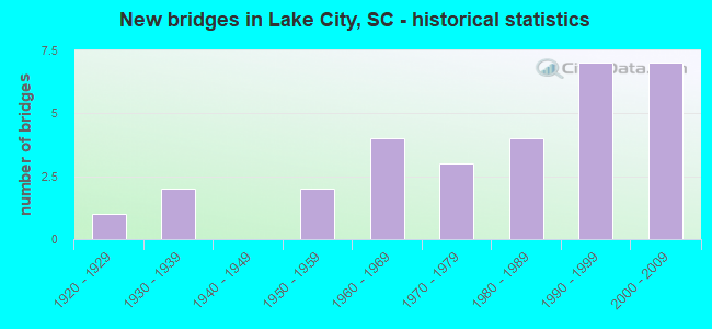
- New bridges - historical statistics
- 11920-1929
- 21930-1939
- 21950-1959
- 41960-1969
- 31970-1979
- 41980-1989
- 71990-1999
- 72000-2009
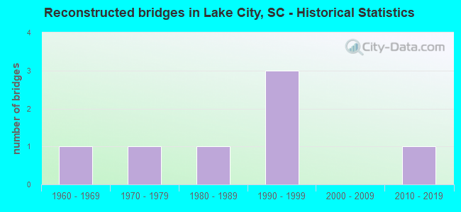
- Reconstructed bridges - Historical Statistics
- 11960-1969
- 11970-1979
- 11980-1989
- 31990-1999
- 02000-2009
- 12010-2019

- Bridge Condition - Deck
- 24.0%Very good
- 28.0%Good
- 40.0%Satisfactory
- 8.0%Fair
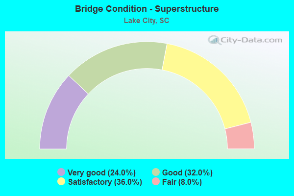
- Bridge Condition - Superstructure
- 24.0%Very good
- 32.0%Good
- 36.0%Satisfactory
- 8.0%Fair
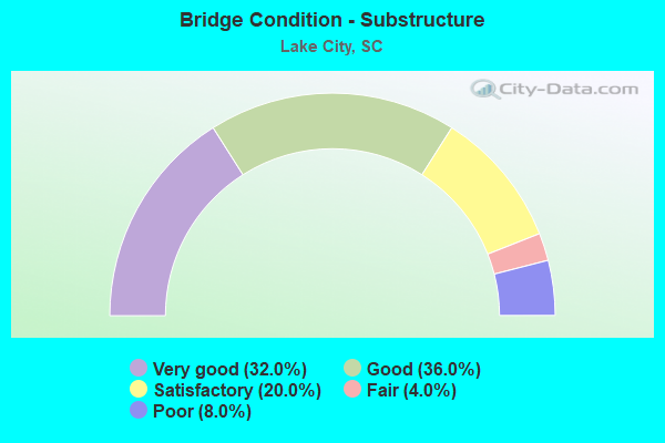
- Bridge Condition - Substructure
- 32.0%Very good
- 36.0%Good
- 20.0%Satisfactory
- 4.0%Fair
- 8.0%Poor
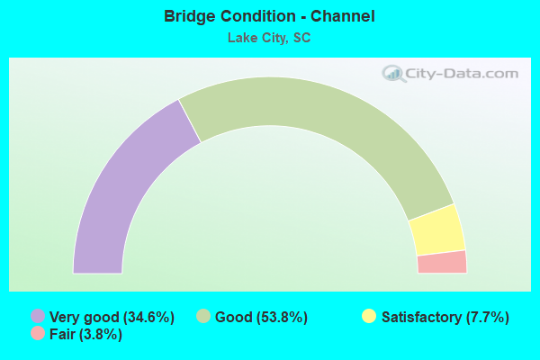
- Bridge Condition - Channel
- 34.6%Very good
- 53.8%Good
- 7.7%Satisfactory
- 3.8%Fair
Find on map >> Show street view
Structure Number: 283, Location: 0.5MI N OF LAKE CITY (Lat: 33.884669, Lng: -79.757603), Route carried "on" structure: US 52, Year Built: 1928, Year Reconstructed: 1974, Status: Open, Structure Length: 8.38m (27.49ft), Average Daily Traffic: 14,200 (year 2020), Truck Traffic: 5%, Average Future Daily Traffic: 22,152 (year 2040), Design Load: HS 15, Features Intersected: LYNCHES LAKE
Minimum Vertical Clearance: 30+ m (98+ ft), Kilometerpoint: 5.570, Lanes on structure: 5, Base Highway Network: Yes, Owner: State Highway Agency, Approaching Roadway Width: 19.8m (65.0ft), Material/Design: Concrete, Design/Construction: Tee Beam, Number Of Spans In Main Unit: 11, Length of Maximum Span: 7.6m (24.9ft), Curb or Sidewalk Widths: Left: 1.5m (4.9ft), Right: 1.5m (4.9ft), Curb-To-Curb Width: 19.8m (65.0ft), Out-to-Out Width: 23.6m (77.4ft)
Condition: Deck: Good, Superstructure: Good, Substructure: Good, Channel: Good, Operating Rating: 13.3 metric tons, Method Used To Determine Operating Rating: Load and Resistance Factor Rating (LRFR) rating reported by rating factor(RF) method using HL-93 loadings, Inventory Rating: 10.4 metric tons, Method Used To Determine Inventory Rating: Load and Resistance Factor Rating (LRFR) rating reported by rating factor(RF) method using HL-93 loadings, Structural Evaluation: High priority of corrective action, Deck Geometry: Meets minimum limits, Waterway Adequacy: Equal to present desirable criteria, Approach Roadway Alignment: Equal to present desirable criteria, Bridge Posting: Required (Relationship of Operating Rating to Maximum Legal Load: > 39.9% below), Length Of Structure Improvement: 9.45m (31.00ft), Designated Inspection Frequency: Every 24 months, Underwater Inspection Frequency: Every 60 months, Inspection Date: March 2020, Underwater Inspection Date: November 2021, Deck Structure Type: Concrete Cast-file-Place, Wearing Surface/Protective System: Wearing Surface: Bituminous
Find on map >> Show street view
Structure Number: 861, Location: 3MI NW OF LAKE CITY (Lat: 33.887831, Lng: -79.801128), Route carried "on" structure: US 378, Year Built: 1938, Year Reconstructed: 1998, Status: Open, Structure Length: 1.22m (4.00ft), Average Daily Traffic: 5,600 (year 2020), Truck Traffic: 10%, Average Future Daily Traffic: 9,744 (year 2040), Design Load: H 20, Features Intersected: BR OF LYNCHES LAKE
Minimum Vertical Clearance: 30+ m (98+ ft), Kilometerpoint: 13.700, Lanes on structure: 4, Base Highway Network: Yes, Owner: State Highway Agency, Approaching Roadway Width: 21.3m (69.9ft), Material/Design: Concrete, Design/Construction: Culvert, Number Of Spans In Main Unit: 3, Length of Maximum Span: 3.0m (9.8ft), Curb-To-Curb Width: 10.2m (33.5ft), Out-to-Out Width: 21.9m (71.9ft)
Condition: Channel: Good, Culverts: Good, Operating Rating: 23.3 metric tons, Method Used To Determine Operating Rating: Load and Resistance Factor Rating (LRFR) rating reported by rating factor(RF) method using HL-93 loadings, Inventory Rating: 18.1 metric tons, Method Used To Determine Inventory Rating: Load and Resistance Factor Rating (LRFR) rating reported by rating factor(RF) method using HL-93 loadings, Structural Evaluation: Meets minimum limits, Deck Geometry: High priority of replacement, Waterway Adequacy: Equal to present desirable criteria, Approach Roadway Alignment: Equal to present desirable criteria, Bridge Posting: Required (Relationship of Operating Rating to Maximum Legal Load: > 39.9% below), Length Of Structure Improvement: 1.89m (6.20ft), Designated Inspection Frequency: Every 24 months, Inspection Date: March 2020, Bridge Improvement Cost: $239,000, Roadway Improvement Cost: $60,000, Total Project Cost: $359,000 ( Estimate for 2021)
Find on map >> Show street view
Structure Number: 863, Location: 1MI NW OF LAKE CITY (Lat: 33.879175, Lng: -79.771253), Route carried "on" structure: Business US 378, Year Built: 1938, Status: Open, Structure Length: 0.70m (2.30ft), Average Daily Traffic: 6,300 (year 2020), Truck Traffic: 7%, Average Future Daily Traffic: 8,883 (year 2040), Design Load: H 20, Features Intersected: CAMP BRANCH
Minimum Vertical Clearance: 30+ m (98+ ft), Kilometerpoint: 2.309, Lanes on structure: 2, Owner: State Highway Agency, Approaching Roadway Width: 7.3m (24.0ft), Material/Design: Concrete, Design/Construction: Culvert, Number Of Spans In Main Unit: 2, Length of Maximum Span: 3.0m (9.8ft), Curb-To-Curb Width: 9.9m (32.5ft), Out-to-Out Width: 10.5m (34.4ft)
Condition: Channel: Good, Culverts: Good, Operating Rating: 15.9 metric tons, Method Used To Determine Operating Rating: Load and Resistance Factor Rating (LRFR) rating reported by rating factor(RF) method using HL-93 loadings, Inventory Rating: 12.3 metric tons, Method Used To Determine Inventory Rating: Load and Resistance Factor Rating (LRFR) rating reported by rating factor(RF) method using HL-93 loadings, Structural Evaluation: High priority of corrective action, Deck Geometry: Meets minimum limits, Waterway Adequacy: Equal to present desirable criteria, Approach Roadway Alignment: Equal to present desirable criteria, Length Of Structure Improvement: 1.32m (4.33ft), Designated Inspection Frequency: Every 24 months, Inspection Date: March 2020, Bridge Improvement Cost: $53,000, Roadway Improvement Cost: $13,000, Total Project Cost: $80,000 ( Estimate for 2021)
Find on map >> Show street view
Structure Number: 1904, Location: 1 MI S OF FLORENCE CO LN (Lat: 33.826686, Lng: -79.772056), Route carried "on" structure: US 52, Year Built: 1952, Year Reconstructed: 1970, Status: Open, Structure Length: 0.64m (2.10ft), Average Daily Traffic: 5,600 (year 2020), Truck Traffic: 12%, Average Future Daily Traffic: 8,736 (year 2040), Design Load: H 20, Features Intersected: SMITH SWAMP
Minimum Vertical Clearance: 30+ m (98+ ft), Kilometerpoint: 45.701, Lanes on structure: 2, Base Highway Network: Yes, Owner: State Highway Agency, Approaching Roadway Width: 17.2m (56.4ft), Skew: 20 degrees, Material/Design: Concrete, Design/Construction: Culvert, Number Of Spans In Main Unit: 2, Length of Maximum Span: 3.0m (9.8ft)
Condition: Channel: Good, Culverts: Good, Operating Rating: 10.4 metric tons, Method Used To Determine Operating Rating: Load and Resistance Factor Rating (LRFR) rating reported by rating factor(RF) method using HL-93 loadings, Inventory Rating: 7.8 metric tons, Method Used To Determine Inventory Rating: Load and Resistance Factor Rating (LRFR) rating reported by rating factor(RF) method using HL-93 loadings, Structural Evaluation: High priority of replacement, Waterway Adequacy: Equal to present desirable criteria, Approach Roadway Alignment: Equal to present desirable criteria, Length Of Structure Improvement: 1.25m (4.10ft), Designated Inspection Frequency: Every 24 months, Inspection Date: November 2020, Bridge Improvement Cost: $137,000, Roadway Improvement Cost: $34,000, Total Project Cost: $206,000 ( Estimate for 2021)
Find on map >> Show street view
Structure Number: 2524, Location: 2MI NW OF LAKE CITY (Lat: 33.891611, Lng: -79.783011), Route carried "on" structure: US 378, Year Built: 2004, Status: Open, Structure Length: 2.74m (8.99ft), Average Daily Traffic: 7,300 (year 2020), Truck Traffic: 10%, Average Future Daily Traffic: 12,702 (year 2040), Design Load: HS 25 or greater, Features Intersected: CAMP BRANCH
Minimum Vertical Clearance: 30+ m (98+ ft), Kilometerpoint: 15.446, Lanes on structure: 5, Base Highway Network: Yes, Owner: State Highway Agency, Approaching Roadway Width: 21.3m (69.9ft), Material/Design: Concrete continuous, Design/Construction: Slab, Number Of Spans In Main Unit: 3, Length of Maximum Span: 9.1m (29.9ft), Curb-To-Curb Width: 25.3m (83.0ft), Out-to-Out Width: 26.2m (86.0ft)
Condition: Deck: Very good, Superstructure: Very good, Substructure: Very good, Channel: Very good, Operating Rating: 59.3 metric tons, Method Used To Determine Operating Rating: Load and Resistance Factor Rating (LRFR) rating reported by rating factor(RF) method using HL-93 loadings, Inventory Rating: 45.7 metric tons, Method Used To Determine Inventory Rating: Load and Resistance Factor Rating (LRFR) rating reported by rating factor(RF) method using HL-93 loadings, Structural Evaluation: Equal to present desirable criteria, Deck Geometry: Superior to present desirable criteria, Waterway Adequacy: Equal to present desirable criteria, Approach Roadway Alignment: Equal to present desirable criteria, Length Of Structure Improvement: 2.74m (8.99ft), Designated Inspection Frequency: Every 24 months, Inspection Date: March 2020, Deck Structure Type: Concrete Cast-file-Place, Wearing Surface/Protective System: Wearing Surface: Monolithic Concrete
Find on map >> Show street view
Structure Number: 2525, Location: 1MI NW OF LAKE CITY (Lat: 33.893431, Lng: -79.760094), Route carried "on" structure: US 378, Year Built: 2004, Status: Open, Structure Length: 2.74m (8.99ft), Average Daily Traffic: 7,300 (year 2020), Truck Traffic: 10%, Average Future Daily Traffic: 11,388 (year 2040), Design Load: HS 25 or greater, Features Intersected: CYPRESS SWAMP
Minimum Vertical Clearance: 30+ m (98+ ft), Kilometerpoint: 17.608, Lanes on structure: 4, Base Highway Network: Yes, Owner: State Highway Agency, Approaching Roadway Width: 21.3m (69.9ft), Skew: 1 degrees, Material/Design: Concrete continuous, Design/Construction: Slab, Number Of Spans In Main Unit: 3, Length of Maximum Span: 9.1m (29.9ft), Curb-To-Curb Width: 28.7m (94.2ft), Out-to-Out Width: 29.8m (97.8ft)
Condition: Deck: Very good, Superstructure: Very good, Substructure: Very good, Channel: Very good, Operating Rating: 62.2 metric tons, Method Used To Determine Operating Rating: Load and Resistance Factor Rating (LRFR) rating reported by rating factor(RF) method using HL-93 loadings, Inventory Rating: 48.0 metric tons, Method Used To Determine Inventory Rating: Load and Resistance Factor Rating (LRFR) rating reported by rating factor(RF) method using HL-93 loadings, Structural Evaluation: Equal to present desirable criteria, Deck Geometry: Superior to present desirable criteria, Waterway Adequacy: Equal to present desirable criteria, Approach Roadway Alignment: Equal to present desirable criteria, Length Of Structure Improvement: 2.74m (8.99ft), Designated Inspection Frequency: Every 24 months, Inspection Date: March 2020, Deck Structure Type: Concrete Cast-file-Place, Wearing Surface/Protective System: Wearing Surface: Monolithic Concrete
Find on map >> Show street view
Structure Number: 2526, Location: 1.5 MI N OF LAKE CITY (Lat: 33.893825, Lng: -79.754567), Route carried "on" structure: US 378, Year Built: 2000, Status: Open, Structure Length: 6.74m (22.11ft), Average Daily Traffic: 7,300 (year 2020), Truck Traffic: 10%, Average Future Daily Traffic: 11,388 (year 2040), Design Load: HS 20, Features Intersected: U.S. 52
Minimum Vertical Clearance: 30+ m (98+ ft), Kilometerpoint: 18.104, Lanes on structure: 4, Lanes under structure: 4, Base Highway Network: Yes, Owner: State Highway Agency, Approaching Roadway Width: 22.9m (75.1ft), Skew: 2 degrees, Material/Design: Steel, Design/Construction: Stringer/Multi-beam, Number Of Spans In Main Unit: 3, Length of Maximum Span: 39.0m (128.0ft), Curb-To-Curb Width: 25.3m (83.0ft), Out-to-Out Width: 26.2m (86.0ft)
Condition: Deck: Very good, Superstructure: Very good, Substructure: Very good, Operating Rating: 51.8 metric tons, Method Used To Determine Operating Rating: Load and Resistance Factor Rating (LRFR) rating reported by rating factor(RF) method using HL-93 loadings, Inventory Rating: 39.9 metric tons, Method Used To Determine Inventory Rating: Load and Resistance Factor Rating (LRFR) rating reported by rating factor(RF) method using HL-93 loadings, Structural Evaluation: Equal to present desirable criteria, Deck Geometry: Superior to present desirable criteria, Underclear: Better than present minimum criteria, Approach Roadway Alignment: Equal to present desirable criteria, Length Of Structure Improvement: 6.74m (22.11ft), Designated Inspection Frequency: Every 24 months, Inspection Date: March 2020, Deck Structure Type: Concrete Cast-file-Place, Wearing Surface/Protective System: Wearing Surface: Monolithic Concrete
Find on map >> Show street view
Structure Number: 2527, Location: 2MI N OF LAKE CITY (Lat: 33.893564, Lng: -79.747503), Route carried "on" structure: US 378, Year Built: 2004, Status: Open, Structure Length: 7.35m (24.11ft), Average Daily Traffic: 7,300 (year 2020), Truck Traffic: 10%, Average Future Daily Traffic: 11,388 (year 2040), Design Load: HS 25 or greater, Features Intersected: S.C.L. RAILROAD_& L-519
Minimum Vertical Clearance: 30+ m (98+ ft), Kilometerpoint: 18.775, Lanes on structure: 4, Lanes under structure: 2, Base Highway Network: Yes, Owner: State Highway Agency, Approaching Roadway Width: 22.9m (75.1ft), Material/Design: Concrete continuous, Design/Construction: Stringer/Multi-beam, Number Of Spans In Main Unit: 4, Length of Maximum Span: 18.3m (60.0ft), Curb-To-Curb Width: 25.3m (83.0ft), Out-to-Out Width: 26.2m (86.0ft)
Condition: Deck: Very good, Superstructure: Very good, Substructure: Very good, Operating Rating: 48.3 metric tons, Method Used To Determine Operating Rating: Load and Resistance Factor Rating (LRFR) rating reported by rating factor(RF) method using HL-93 loadings, Inventory Rating: 37.3 metric tons, Method Used To Determine Inventory Rating: Load and Resistance Factor Rating (LRFR) rating reported by rating factor(RF) method using HL-93 loadings, Structural Evaluation: Equal to present desirable criteria, Deck Geometry: Superior to present desirable criteria, Underclear: Meets minimum limits, Approach Roadway Alignment: Equal to present desirable criteria, Length Of Structure Improvement: 7.35m (24.11ft), Designated Inspection Frequency: Every 24 months, Inspection Date: March 2020, Deck Structure Type: Concrete Cast-file-Place, Wearing Surface/Protective System: Wearing Surface: Monolithic Concrete
Find on map >> Show street view
Structure Number: 2528, Location: 5MI SE OF LAKE CITY (Lat: 33.841864, Lng: -79.681861), Route carried "on" structure: State highway 341, Year Built: 1957, Status: Open, Structure Length: 6.40m (21.00ft), Average Daily Traffic: 2,200 (year 2020), Truck Traffic: 11%, Average Future Daily Traffic: 3,212 (year 2040), Design Load: HS 15, Features Intersected: LYNCHES LAKE (NO. 1)
Minimum Vertical Clearance: 30+ m (98+ ft), Kilometerpoint: 31.142, Lanes on structure: 2, Owner: State Highway Agency, Approaching Roadway Width: 7.9m (25.9ft), Material/Design: Concrete, Design/Construction: Tee Beam, Number Of Spans In Main Unit: 7, Length of Maximum Span: 9.1m (29.9ft), Curb or Sidewalk Widths: Left: 0.5m (1.6ft), Right: 0.5m (1.6ft), Curb-To-Curb Width: 8.7m (28.5ft), Out-to-Out Width: 9.0m (29.5ft)
Condition: Deck: Satisfactory, Superstructure: Good, Substructure: Good, Channel: Good, Operating Rating: 29.2 metric tons, Method Used To Determine Operating Rating: Load and Resistance Factor Rating (LRFR) rating reported by rating factor(RF) method using HL-93 loadings, Inventory Rating: 22.4 metric tons, Method Used To Determine Inventory Rating: Load and Resistance Factor Rating (LRFR) rating reported by rating factor(RF) method using HL-93 loadings, Structural Evaluation: Somewhat better than minimum adequacy, Deck Geometry: Meets minimum limits, Waterway Adequacy: Equal to present desirable criteria, Approach Roadway Alignment: Equal to present desirable criteria, Bridge Posting: Required (Relationship of Operating Rating to Maximum Legal Load: 0.1 - 9.9% below), Length Of Structure Improvement: 6.40m (21.00ft), Designated Inspection Frequency: Every 24 months, Underwater Inspection Frequency: Every 60 months, Inspection Date: March 2020, Underwater Inspection Date: December 2021, Deck Structure Type: Concrete Cast-file-Place, Wearing Surface/Protective System: Wearing Surface: Monolithic Concrete
Find on map >> Show street view
Structure Number: 328, Location: 2MI NE LAKE CITY (Lat: 33.879692, Lng: -79.710714), Route carried "on" structure: State highway 556, Year Built: 1960, Year Reconstructed: 1995, Status: Open, Structure Length: 0.91m (2.99ft), Average Daily Traffic: 600 (year 2020), Truck Traffic: 5%, Average Future Daily Traffic: 768 (year 2040), Design Load: H 10, Features Intersected: BR OF LYNCHES LAKE
Minimum Vertical Clearance: 30+ m (98+ ft), Kilometerpoint: 1.259, Lanes on structure: 2, Owner: State Highway Agency, Approaching Roadway Width: 6.1m (20.0ft), Material/Design: Concrete, Design/Construction: Slab, Number Of Spans In Main Unit: 2, Length of Maximum Span: 4.6m (15.1ft), Curb-To-Curb Width: 7.9m (25.9ft), Out-to-Out Width: 8.5m (27.9ft)
Condition: Deck: Satisfactory, Superstructure: Satisfactory, Substructure: Satisfactory, Channel: Very good, Operating Rating: 19.4 metric tons, Method Used To Determine Operating Rating: Load and Resistance Factor Rating (LRFR) rating reported by rating factor(RF) method using HL-93 loadings, Inventory Rating: 14.9 metric tons, Method Used To Determine Inventory Rating: Load and Resistance Factor Rating (LRFR) rating reported by rating factor(RF) method using HL-93 loadings, Structural Evaluation: Meets minimum limits, Deck Geometry: Somewhat better than minimum adequacy, Waterway Adequacy: Equal to present minimum criteria, Approach Roadway Alignment: Equal to present desirable criteria, Bridge Posting: Required (Relationship of Operating Rating to Maximum Legal Load: 30.0 - 39.9% below), Length Of Structure Improvement: 0.91m (2.99ft), Designated Inspection Frequency: Every 24 months, Inspection Date: April 2021, Deck Structure Type: Concrete Precast Panels, Wearing Surface/Protective System: Wearing Surface: Bituminous
Find on map >> Show street view
Structure Number: 3871, Location: 4MI NW LAKE CITY (Lat: 33.922733, Lng: -79.798094), Route carried "on" structure: State highway 558, Year Built: 1962, Year Reconstructed: 1992, Status: Open, Structure Length: 0.91m (2.99ft), Average Daily Traffic: 325 (year 2020), Truck Traffic: 5%, Average Future Daily Traffic: 416 (year 2040), Design Load: H 10, Features Intersected: CYPRESS CREEK
Minimum Vertical Clearance: 30+ m (98+ ft), Kilometerpoint: 1.955, Lanes on structure: 2, Owner: State Highway Agency, Approaching Roadway Width: 6.1m (20.0ft), Material/Design: Concrete, Design/Construction: Slab, Number Of Spans In Main Unit: 2, Length of Maximum Span: 4.6m (15.1ft), Curb-To-Curb Width: 7.9m (25.9ft), Out-to-Out Width: 8.5m (27.9ft)
Condition: Deck: Satisfactory, Superstructure: Satisfactory, Substructure: Satisfactory, Channel: Good, Operating Rating: 21.4 metric tons, Method Used To Determine Operating Rating: Load and Resistance Factor Rating (LRFR) rating reported by rating factor(RF) method using HL-93 loadings, Inventory Rating: 16.5 metric tons, Method Used To Determine Inventory Rating: Load and Resistance Factor Rating (LRFR) rating reported by rating factor(RF) method using HL-93 loadings, Structural Evaluation: Somewhat better than minimum adequacy, Deck Geometry: Somewhat better than minimum adequacy, Waterway Adequacy: Equal to present minimum criteria, Approach Roadway Alignment: Equal to present desirable criteria, Bridge Posting: Required (Relationship of Operating Rating to Maximum Legal Load: 20.0 - 29.9% below), Length Of Structure Improvement: 0.91m (2.99ft), Designated Inspection Frequency: Every 24 months, Inspection Date: April 2021, Deck Structure Type: Concrete Precast Panels, Wearing Surface/Protective System: Wearing Surface: Bituminous
Find on map >> Show street view
Structure Number: 4677, Location: 4.3 MI NE CADES (Lat: 33.818800, Lng: -79.753953), Route carried "on" structure: County highway 400, Year Built: 1965, Status: Posted for load, Structure Length: 0.91m (2.99ft), Average Daily Traffic: 200 (year 2020), Truck Traffic: 5%, Average Future Daily Traffic: 256 (year 2040), Design Load: H 10, Features Intersected: SMITHS SWAMP
Minimum Vertical Clearance: 30+ m (98+ ft), Kilometerpoint: 0.315, Lanes on structure: 2, Owner: County Highway Agency, Approaching Roadway Width: 5.5m (18.0ft), Material/Design: Concrete, Design/Construction: Slab, Number Of Spans In Main Unit: 2, Length of Maximum Span: 4.6m (15.1ft), Curb-To-Curb Width: 7.9m (25.9ft), Out-to-Out Width: 8.4m (27.6ft)
Condition: Deck: Satisfactory, Superstructure: Satisfactory, Substructure: Poor, Channel: Fair, Operating Rating: 21.7 metric tons, Method Used To Determine Operating Rating: Load and Resistance Factor Rating (LRFR) rating reported by rating factor(RF) method using HL-93 loadings, Inventory Rating: 16.8 metric tons, Method Used To Determine Inventory Rating: Load and Resistance Factor Rating (LRFR) rating reported by rating factor(RF) method using HL-93 loadings, Structural Evaluation: Meets minimum limits, Deck Geometry: Somewhat better than minimum adequacy, Waterway Adequacy: Superior to present desirable criteria, Approach Roadway Alignment: Equal to present desirable criteria, Bridge Posting: Required (Relationship of Operating Rating to Maximum Legal Load: 20.0 - 29.9% below), Length Of Structure Improvement: 1.55m (5.09ft), Designated Inspection Frequency: Every 12 months, Inspection Date: October 2021, Bridge Improvement Cost: $137,000, Roadway Improvement Cost: $34,000, Total Project Cost: $206,000 ( Estimate for 2021), Deck Structure Type: Concrete Precast Panels, Wearing Surface/Protective System: Wearing Surface: Other
Find on map >> Show street view
Structure Number: 4785, Location: IN LAKE CITY (Lat: 33.877900, Lng: -79.748503), Route carried "on" structure: Business US 378, Year Built: 1966, Status: Open, Structure Length: 9.14m (29.99ft), Average Daily Traffic: 5,200 (year 2020), Truck Traffic: 4%, Average Future Daily Traffic: 7,332 (year 2040), Design Load: HS 20, Features Intersected: LYNCHES LAKE
Minimum Vertical Clearance: 30+ m (98+ ft), Kilometerpoint: 4.926, Lanes on structure: 4, Owner: State Highway Agency, Approaching Roadway Width: 14.6m (47.9ft), Material/Design: Concrete, Design/Construction: Slab, Number Of Spans In Main Unit: 12, Length of Maximum Span: 7.6m (24.9ft), Curb or Sidewalk Widths: Left: 1.2m (3.9ft), Right: 1.2m (3.9ft), Curb-To-Curb Width: 16.5m (54.1ft), Out-to-Out Width: 19.5m (64.0ft)
Condition: Deck: Satisfactory, Superstructure: Satisfactory, Substructure: Good, Channel: Good, Operating Rating: 40.8 metric tons, Method Used To Determine Operating Rating: Load and Resistance Factor Rating (LRFR) rating reported by rating factor(RF) method using HL-93 loadings, Inventory Rating: 31.4 metric tons, Method Used To Determine Inventory Rating: Load and Resistance Factor Rating (LRFR) rating reported by rating factor(RF) method using HL-93 loadings, Structural Evaluation: Equal to present minimum criteria, Deck Geometry: Meets minimum limits, Waterway Adequacy: Equal to present desirable criteria, Approach Roadway Alignment: Equal to present desirable criteria, Length Of Structure Improvement: 9.14m (29.99ft), Designated Inspection Frequency: Every 24 months, Underwater Inspection Frequency: Every 60 months, Inspection Date: March 2020, Underwater Inspection Date: November 2021, Deck Structure Type: Concrete Cast-file-Place, Wearing Surface/Protective System: Wearing Surface: Monolithic Concrete
Find on map >> Show street view
Structure Number: 573, Location: 3MI NW LAKE CITY (Lat: 33.901436, Lng: -79.803861), Route carried "on" structure: State highway 1205, Year Built: 1970, Status: Open, Structure Length: 1.83m (6.00ft), Average Daily Traffic: 225 (year 2020), Truck Traffic: 5%, Average Future Daily Traffic: 288 (year 2040), Design Load: H 10, Features Intersected: CAMP BRANCH CANAL
Minimum Vertical Clearance: 30+ m (98+ ft), Kilometerpoint: 0.349, Lanes on structure: 2, Owner: State Highway Agency, Approaching Roadway Width: 6.1m (20.0ft), Material/Design: Concrete, Design/Construction: Slab, Number Of Spans In Main Unit: 4, Length of Maximum Span: 4.6m (15.1ft), Curb-To-Curb Width: 7.9m (25.9ft), Out-to-Out Width: 8.6m (28.2ft)
Condition: Deck: Fair, Superstructure: Fair, Substructure: Fair, Channel: Satisfactory, Operating Rating: 19.1 metric tons, Method Used To Determine Operating Rating: Load and Resistance Factor Rating (LRFR) rating reported by rating factor(RF) method using HL-93 loadings, Inventory Rating: 14.6 metric tons, Method Used To Determine Inventory Rating: Load and Resistance Factor Rating (LRFR) rating reported by rating factor(RF) method using HL-93 loadings, Structural Evaluation: Meets minimum limits, Deck Geometry: Somewhat better than minimum adequacy, Waterway Adequacy: Equal to present desirable criteria, Approach Roadway Alignment: Equal to present desirable criteria, Bridge Posting: Required (Relationship of Operating Rating to Maximum Legal Load: 30.0 - 39.9% below), Length Of Structure Improvement: 1.83m (6.00ft), Designated Inspection Frequency: Every 24 months, Inspection Date: April 2021, Deck Structure Type: Concrete Precast Panels, Wearing Surface/Protective System: Wearing Surface: Bituminous
Find on map >> Show street view
Structure Number: 62, Location: 11.0 MI N KINGSTREE (Lat: 33.860522, Lng: -79.824411), Route carried "on" structure: State highway 33, Year Built: 1972, Year Reconstructed: 2001, Status: Open, Structure Length: 0.91m (2.99ft), Average Daily Traffic: 1,350 (year 2021), Truck Traffic: 4%, Average Future Daily Traffic: 1,971 (year 2041), Design Load: H 10, Features Intersected: SMITH SWAMP
Minimum Vertical Clearance: 30+ m (98+ ft), Kilometerpoint: 0.538, Lanes on structure: 2, Owner: State Highway Agency, Approaching Roadway Width: 7.0m (23.0ft), Material/Design: Concrete, Design/Construction: Slab, Number Of Spans In Main Unit: 2, Length of Maximum Span: 4.6m (15.1ft), Curb-To-Curb Width: 7.9m (25.9ft), Out-to-Out Width: 8.6m (28.2ft)
Condition: Deck: Satisfactory, Superstructure: Satisfactory, Substructure: Good, Channel: Good, Operating Rating: 19.8 metric tons, Method Used To Determine Operating Rating: Load and Resistance Factor Rating (LRFR) rating reported by rating factor(RF) method using HL-93 loadings, Inventory Rating: 15.2 metric tons, Method Used To Determine Inventory Rating: Load and Resistance Factor Rating (LRFR) rating reported by rating factor(RF) method using HL-93 loadings, Structural Evaluation: Meets minimum limits, Deck Geometry: Meets minimum limits, Waterway Adequacy: Superior to present desirable criteria, Approach Roadway Alignment: Equal to present desirable criteria, Bridge Posting: Required (Relationship of Operating Rating to Maximum Legal Load: 30.0 - 39.9% below), Length Of Structure Improvement: 0.91m (2.99ft), Designated Inspection Frequency: Every 24 months, Inspection Date: October 2020, Deck Structure Type: Concrete Precast Panels, Wearing Surface/Protective System: Wearing Surface: Bituminous
Find on map >> Show street view
Structure Number: 6387, Location: 3.0 MI NE CADES (Lat: 33.801322, Lng: -79.742828), Route carried "on" structure: State highway 552, Year Built: 2005, Status: Open, Structure Length: 1.83m (6.00ft), Average Daily Traffic: 175 (year 2021), Truck Traffic: 5%, Average Future Daily Traffic: 224 (year 2041), Design Load: H 10, Features Intersected: SMITH SWAMP
Minimum Vertical Clearance: 30+ m (98+ ft), Kilometerpoint: 0.943, Lanes on structure: 2, Owner: State Highway Agency, Approaching Roadway Width: 7.3m (24.0ft), Material/Design: Concrete, Design/Construction: Slab, Number Of Spans In Main Unit: 4, Length of Maximum Span: 4.6m (15.1ft), Curb-To-Curb Width: 7.9m (25.9ft), Out-to-Out Width: 8.6m (28.2ft)
Condition: Deck: Fair, Superstructure: Fair, Substructure: Satisfactory, Channel: Good, Operating Rating: 19.4 metric tons, Method Used To Determine Operating Rating: Load and Resistance Factor Rating (LRFR) rating reported by rating factor(RF) method using HL-93 loadings, Inventory Rating: 14.9 metric tons, Method Used To Determine Inventory Rating: Load and Resistance Factor Rating (LRFR) rating reported by rating factor(RF) method using HL-93 loadings, Structural Evaluation: Meets minimum limits, Deck Geometry: Somewhat better than minimum adequacy, Waterway Adequacy: Superior to present desirable criteria, Approach Roadway Alignment: Equal to present desirable criteria, Bridge Posting: Required (Relationship of Operating Rating to Maximum Legal Load: 30.0 - 39.9% below), Length Of Structure Improvement: 1.83m (6.00ft), Designated Inspection Frequency: Every 24 months, Inspection Date: August 2021, Deck Structure Type: Concrete Precast Panels, Wearing Surface/Protective System: Wearing Surface: Bituminous
Find on map >> Show street view
Structure Number: 6664, Location: 4 MI W SCRANTON (Lat: 33.906761, Lng: -79.810883), Route carried "on" structure: State highway 56, Year Built: 1975, Year Reconstructed: 2019, Status: Posted for load, Structure Length: 1.83m (6.00ft), Average Daily Traffic: 950 (year 2021), Truck Traffic: 9%, Average Future Daily Traffic: 1,387 (year 2041), Design Load: H 10, Features Intersected: CAMP BRANCH
Minimum Vertical Clearance: 30+ m (98+ ft), Kilometerpoint: 0.225, Lanes on structure: 2, Owner: State Highway Agency, Approaching Roadway Width: 7.3m (24.0ft), Material/Design: Concrete, Design/Construction: Slab, Number Of Spans In Main Unit: 4, Length of Maximum Span: 4.6m (15.1ft), Curb-To-Curb Width: 7.9m (25.9ft), Out-to-Out Width: 8.6m (28.2ft)
Condition: Deck: Satisfactory, Superstructure: Satisfactory, Substructure: Good, Channel: Good, Operating Rating: 18.8 metric tons, Method Used To Determine Operating Rating: Load and Resistance Factor Rating (LRFR) rating reported by rating factor(RF) method using HL-93 loadings, Inventory Rating: 14.6 metric tons, Method Used To Determine Inventory Rating: Load and Resistance Factor Rating (LRFR) rating reported by rating factor(RF) method using HL-93 loadings, Structural Evaluation: Meets minimum limits, Deck Geometry: Somewhat better than minimum adequacy, Waterway Adequacy: Equal to present minimum criteria, Approach Roadway Alignment: Equal to present desirable criteria, Bridge Posting: Required (Relationship of Operating Rating to Maximum Legal Load: 30.0 - 39.9% below), Length Of Structure Improvement: 1.83m (6.00ft), Designated Inspection Frequency: Every 24 months, Inspection Date: April 2021, Deck Structure Type: Concrete Precast Panels, Wearing Surface/Protective System: Wearing Surface: Bituminous
Find on map >> Show street view
Structure Number: 763, Location: 11.0 MI N KINGSTREE (Lat: 33.850592, Lng: -79.839925), Route carried "on" structure: State highway 33, Year Built: 1982, Status: Open, Structure Length: 1.37m (4.49ft), Average Daily Traffic: 1,450 (year 2020), Truck Traffic: 9%, Average Future Daily Traffic: 2,117 (year 2040), Design Load: H 15, Features Intersected: KINGSTREE SWAMP
Minimum Vertical Clearance: 30+ m (98+ ft), Kilometerpoint: 2.440, Lanes on structure: 2, Owner: State Highway Agency, Approaching Roadway Width: 6.7m (22.0ft), Material/Design: Concrete, Design/Construction: Slab, Number Of Spans In Main Unit: 3, Length of Maximum Span: 4.6m (15.1ft), Curb-To-Curb Width: 9.6m (31.5ft), Out-to-Out Width: 10.1m (33.1ft)
Condition: Deck: Good, Superstructure: Good, Substructure: Poor, Channel: Satisfactory, Operating Rating: 21.1 metric tons, Method Used To Determine Operating Rating: Load and Resistance Factor Rating (LRFR) rating reported by rating factor(RF) method using HL-93 loadings, Inventory Rating: 16.2 metric tons, Method Used To Determine Inventory Rating: Load and Resistance Factor Rating (LRFR) rating reported by rating factor(RF) method using HL-93 loadings, Structural Evaluation: Meets minimum limits, Deck Geometry: Somewhat better than minimum adequacy, Waterway Adequacy: Equal to present minimum criteria, Approach Roadway Alignment: Equal to present desirable criteria, Bridge Posting: Required (Relationship of Operating Rating to Maximum Legal Load: 20.0 - 29.9% below), Length Of Structure Improvement: 2.06m (6.76ft), Designated Inspection Frequency: Every 12 months, Inspection Date: September 2021, Bridge Improvement Cost: $208,000, Roadway Improvement Cost: $52,000, Total Project Cost: $312,000 ( Estimate for 2022), Deck Structure Type: Concrete Precast Panels, Wearing Surface/Protective System: Wearing Surface: Bituminous
Find on map >> Show street view
Structure Number: 8115, Location: 7.0 MI NW CADES (Lat: 33.868394, Lng: -79.841897), Route carried "on" structure: State highway 754, Year Built: 1987, Status: Open, Structure Length: 1.37m (4.49ft), Average Daily Traffic: 125 (year 2020), Truck Traffic: 5%, Average Future Daily Traffic: 160 (year 2040), Design Load: HS 20, Features Intersected: SMITHS SWAMP
Minimum Vertical Clearance: 30+ m (98+ ft), Kilometerpoint: 0.011, Lanes on structure: 2, Owner: State Highway Agency, Approaching Roadway Width: 6.4m (21.0ft), Material/Design: Concrete, Design/Construction: Slab, Number Of Spans In Main Unit: 3, Length of Maximum Span: 4.6m (15.1ft), Curb-To-Curb Width: 9.8m (32.2ft), Out-to-Out Width: 11.0m (36.1ft)
Condition: Deck: Good, Superstructure: Good, Substructure: Satisfactory, Channel: Good, Operating Rating: 50.2 metric tons, Method Used To Determine Operating Rating: Load and Resistance Factor Rating (LRFR) rating reported by rating factor(RF) method using HL-93 loadings, Inventory Rating: 38.9 metric tons, Method Used To Determine Inventory Rating: Load and Resistance Factor Rating (LRFR) rating reported by rating factor(RF) method using HL-93 loadings, Structural Evaluation: Equal to present minimum criteria, Deck Geometry: Better than present minimum criteria, Waterway Adequacy: Equal to present desirable criteria, Approach Roadway Alignment: Equal to present desirable criteria, Length Of Structure Improvement: 1.37m (4.49ft), Designated Inspection Frequency: Every 24 months, Inspection Date: August 2021, Deck Structure Type: Concrete Cast-file-Place, Wearing Surface/Protective System: Wearing Surface: Bituminous
Find on map >> Show street view
Structure Number: 8117, Location: 6.0 MI NW CADES (Lat: 33.859425, Lng: -79.841306), Route carried "on" structure: State highway 754, Year Built: 1987, Status: Open, Structure Length: 1.37m (4.49ft), Average Daily Traffic: 125 (year 2020), Truck Traffic: 5%, Average Future Daily Traffic: 160 (year 2040), Design Load: HS 20, Features Intersected: BR- KINGSTREE CANAL
Minimum Vertical Clearance: 30+ m (98+ ft), Kilometerpoint: 2.813, Lanes on structure: 2, Owner: State Highway Agency, Approaching Roadway Width: 6.4m (21.0ft), Material/Design: Concrete, Design/Construction: Slab, Number Of Spans In Main Unit: 3, Length of Maximum Span: 4.6m (15.1ft), Curb-To-Curb Width: 9.8m (32.2ft), Out-to-Out Width: 11.0m (36.1ft)
Condition: Deck: Good, Superstructure: Good, Substructure: Good, Channel: Good, Operating Rating: 50.9 metric tons, Method Used To Determine Operating Rating: Load and Resistance Factor Rating (LRFR) rating reported by rating factor(RF) method using HL-93 loadings, Inventory Rating: 39.2 metric tons, Method Used To Determine Inventory Rating: Load and Resistance Factor Rating (LRFR) rating reported by rating factor(RF) method using HL-93 loadings, Structural Evaluation: Better than present minimum criteria, Deck Geometry: Better than present minimum criteria, Waterway Adequacy: Equal to present desirable criteria, Approach Roadway Alignment: Equal to present desirable criteria, Length Of Structure Improvement: 1.37m (4.49ft), Designated Inspection Frequency: Every 24 months, Inspection Date: August 2021, Deck Structure Type: Concrete Precast Panels, Wearing Surface/Protective System: Wearing Surface: Monolithic Concrete
Find on map >> Show street view
Structure Number: 8257, Location: 2.0 MI NW LAKE CITY (Lat: 33.893514, Lng: -79.787950), Route carried "on" structure: County highway 656, Year Built: 1989, Status: Open, Structure Length: 1.83m (6.00ft), Average Daily Traffic: 125 (year 2020), Truck Traffic: 5%, Average Future Daily Traffic: 160 (year 2040), Design Load: H 10, Features Intersected: CAMP BRANCH
Minimum Vertical Clearance: 30+ m (98+ ft), Kilometerpoint: 1.098, Lanes on structure: 2, Owner: County Highway Agency, Approaching Roadway Width: 5.5m (18.0ft), Material/Design: Concrete, Design/Construction: Slab, Number Of Spans In Main Unit: 4, Length of Maximum Span: 4.6m (15.1ft), Curb-To-Curb Width: 7.9m (25.9ft), Out-to-Out Width: 8.5m (27.9ft)
Condition: Deck: Good, Superstructure: Good, Substructure: Satisfactory, Channel: Very good, Operating Rating: 20.4 metric tons, Method Used To Determine Operating Rating: Load and Resistance Factor Rating (LRFR) rating reported by rating factor(RF) method using HL-93 loadings, Inventory Rating: 15.6 metric tons, Method Used To Determine Inventory Rating: Load and Resistance Factor Rating (LRFR) rating reported by rating factor(RF) method using HL-93 loadings, Structural Evaluation: Meets minimum limits, Deck Geometry: Somewhat better than minimum adequacy, Waterway Adequacy: Superior to present desirable criteria, Approach Roadway Alignment: Equal to present desirable criteria, Bridge Posting: Required (Relationship of Operating Rating to Maximum Legal Load: 30.0 - 39.9% below), Length Of Structure Improvement: 1.83m (6.00ft), Designated Inspection Frequency: Every 24 months, Inspection Date: November 2021, Deck Structure Type: Concrete Precast Panels, Wearing Surface/Protective System: Wearing Surface: Monolithic Concrete
Find on map >> Show street view
Structure Number: 8643, Location: 2 MI NW LAKE CITY (Lat: 33.902706, Lng: -79.771978), Route carried "on" structure: County highway 824, Year Built: 1993, Status: Open, Structure Length: 0.91m (2.99ft), Average Daily Traffic: 125 (year 2020), Truck Traffic: 5%, Average Future Daily Traffic: 160 (year 2040), Design Load: H 10, Features Intersected: CYPRESS SWAMP
Minimum Vertical Clearance: 30+ m (98+ ft), Kilometerpoint: 2.131, Lanes on structure: 2, Owner: County Highway Agency, Approaching Roadway Width: 6.1m (20.0ft), Material/Design: Concrete, Design/Construction: Slab, Number Of Spans In Main Unit: 2, Length of Maximum Span: 4.6m (15.1ft), Curb-To-Curb Width: 7.9m (25.9ft), Out-to-Out Width: 8.4m (27.6ft)
Condition: Deck: Satisfactory, Superstructure: Satisfactory, Substructure: Good, Channel: Good, Operating Rating: 20.4 metric tons, Method Used To Determine Operating Rating: Load and Resistance Factor Rating (LRFR) rating reported by rating factor(RF) method using HL-93 loadings, Inventory Rating: 15.6 metric tons, Method Used To Determine Inventory Rating: Load and Resistance Factor Rating (LRFR) rating reported by rating factor(RF) method using HL-93 loadings, Structural Evaluation: Meets minimum limits, Deck Geometry: Somewhat better than minimum adequacy, Waterway Adequacy: Equal to present desirable criteria, Approach Roadway Alignment: Equal to present desirable criteria, Bridge Posting: Required (Relationship of Operating Rating to Maximum Legal Load: 30.0 - 39.9% below), Length Of Structure Improvement: 0.91m (2.99ft), Designated Inspection Frequency: Every 24 months, Inspection Date: November 2021, Deck Structure Type: Concrete Precast Panels, Wearing Surface/Protective System: Wearing Surface: Monolithic Concrete
Find on map >> Show street view
Structure Number: 8843, Location: 3 MI W SCRANTON (Lat: 33.926258, Lng: -79.801906), Route carried "on" structure: State highway 278, Year Built: 1995, Status: Open, Structure Length: 0.91m (2.99ft), Average Daily Traffic: 850 (year 2020), Truck Traffic: 9%, Average Future Daily Traffic: 1,241 (year 2040), Design Load: HS 20, Features Intersected: CYPRESS SWAMP
Minimum Vertical Clearance: 30+ m (98+ ft), Kilometerpoint: 6.985, Lanes on structure: 2, Owner: State Highway Agency, Approaching Roadway Width: 7.3m (24.0ft), Material/Design: Prestressed concrete, Design/Construction: Slab, Number Of Spans In Main Unit: 1, Length of Maximum Span: 9.1m (29.9ft), Curb-To-Curb Width: 10.5m (34.4ft), Out-to-Out Width: 11.9m (39.0ft)
Condition: Deck: Very good, Superstructure: Very good, Substructure: Good, Channel: Very good, Operating Rating: 29.2 metric tons, Method Used To Determine Operating Rating: Load and Resistance Factor Rating (LRFR) rating reported by rating factor(RF) method using HL-93 loadings, Inventory Rating: 21.1 metric tons, Method Used To Determine Inventory Rating: Load and Resistance Factor Rating (LRFR) rating reported by rating factor(RF) method using HL-93 loadings, Structural Evaluation: Somewhat better than minimum adequacy, Deck Geometry: Equal to present minimum criteria, Waterway Adequacy: Equal to present desirable criteria, Approach Roadway Alignment: Equal to present desirable criteria, Length Of Structure Improvement: 0.91m (2.99ft), Designated Inspection Frequency: Every 24 months, Inspection Date: March 2021, Deck Structure Type: Concrete Precast Panels, Wearing Surface/Protective System: Wearing Surface: Bituminous
Find on map >> Show street view
Structure Number: 8952, Location: 3.0 MI N CADES (Lat: 33.841044, Lng: -79.802833), Route carried "on" structure: State highway 454, Year Built: 1995, Status: Open, Structure Length: 2.01m (6.59ft), Average Daily Traffic: 350 (year 2020), Truck Traffic: 9%, Average Future Daily Traffic: 486 (year 2040), Design Load: HS 25 or greater, Features Intersected: SMITHS SWAMP
Minimum Vertical Clearance: 30+ m (98+ ft), Kilometerpoint: 0.006, Lanes on structure: 2, Owner: State Highway Agency, Approaching Roadway Width: 6.7m (22.0ft), Material/Design: Concrete continuous, Design/Construction: Slab, Number Of Spans In Main Unit: 3, Length of Maximum Span: 6.7m (22.0ft), Curb-To-Curb Width: 10.4m (34.1ft), Out-to-Out Width: 11.3m (37.1ft)
Condition: Deck: Satisfactory, Superstructure: Satisfactory, Substructure: Very good, Channel: Very good, Operating Rating: 60.6 metric tons, Method Used To Determine Operating Rating: Load and Resistance Factor Rating (LRFR) rating reported by rating factor(RF) method using HL-93 loadings, Inventory Rating: 46.7 metric tons, Method Used To Determine Inventory Rating: Load and Resistance Factor Rating (LRFR) rating reported by rating factor(RF) method using HL-93 loadings, Structural Evaluation: Equal to present minimum criteria, Deck Geometry: Better than present minimum criteria, Waterway Adequacy: Superior to present desirable criteria, Approach Roadway Alignment: Equal to present desirable criteria, Length Of Structure Improvement: 2.01m (6.59ft), Designated Inspection Frequency: Every 24 months, Inspection Date: September 2021, Deck Structure Type: Concrete Precast Panels, Wearing Surface/Protective System: Wearing Surface: Monolithic Concrete
Find on map >> Show street view
Structure Number: 9009, Location: 3 MI SE LAKE CITY (Lat: 33.856478, Lng: -79.694331), Route carried "on" structure: State highway 730, Year Built: 1996, Status: Open, Structure Length: 3.66m (12.01ft), Average Daily Traffic: 300 (year 2020), Truck Traffic: 5%, Average Future Daily Traffic: 384 (year 2040), Design Load: HS 25 or greater, Features Intersected: LYNCHES LAKE
Minimum Vertical Clearance: 30+ m (98+ ft), Kilometerpoint: 0.964, Lanes on structure: 2, Owner: State Highway Agency, Approaching Roadway Width: 6.1m (20.0ft), Material/Design: Concrete continuous, Design/Construction: Slab, Number Of Spans In Main Unit: 4, Length of Maximum Span: 9.1m (29.9ft), Curb-To-Curb Width: 10.4m (34.1ft), Out-to-Out Width: 11.3m (37.1ft)
Condition: Deck: Good, Superstructure: Good, Substructure: Very good, Channel: Very good, Operating Rating: 46.3 metric tons, Method Used To Determine Operating Rating: Load and Resistance Factor Rating (LRFR) rating reported by rating factor(RF) method using HL-93 loadings, Inventory Rating: 35.6 metric tons, Method Used To Determine Inventory Rating: Load and Resistance Factor Rating (LRFR) rating reported by rating factor(RF) method using HL-93 loadings, Structural Evaluation: Better than present minimum criteria, Deck Geometry: Better than present minimum criteria, Waterway Adequacy: Equal to present minimum criteria, Approach Roadway Alignment: Equal to present minimum criteria, Length Of Structure Improvement: 3.66m (12.01ft), Designated Inspection Frequency: Every 24 months, Inspection Date: April 2021, Deck Structure Type: Concrete Precast Panels, Wearing Surface/Protective System: Wearing Surface: Monolithic Concrete
Find on map >> Show street view
Structure Number: 901, Location: 3 MI SE LAKE CITY (Lat: 33.855831, Lng: -79.695044), Route carried "on" structure: State highway 730, Year Built: 1996, Status: Open, Structure Length: 4.57m (14.99ft), Average Daily Traffic: 300 (year 2020), Truck Traffic: 5%, Average Future Daily Traffic: 384 (year 2040), Design Load: HS 25 or greater, Features Intersected: LYNCHES LAKE
Minimum Vertical Clearance: 30+ m (98+ ft), Kilometerpoint: 1.056, Lanes on structure: 2, Owner: State Highway Agency, Approaching Roadway Width: 6.1m (20.0ft), Material/Design: Concrete continuous, Design/Construction: Slab, Number Of Spans In Main Unit: 5, Length of Maximum Span: 9.1m (29.9ft), Curb-To-Curb Width: 10.4m (34.1ft), Out-to-Out Width: 11.3m (37.1ft)
Condition: Deck: Good, Superstructure: Good, Substructure: Very good, Channel: Very good, Operating Rating: 46.7 metric tons, Method Used To Determine Operating Rating: Load and Resistance Factor Rating (LRFR) rating reported by rating factor(RF) method using HL-93 loadings, Inventory Rating: 36.0 metric tons, Method Used To Determine Inventory Rating: Load and Resistance Factor Rating (LRFR) rating reported by rating factor(RF) method using HL-93 loadings, Structural Evaluation: Better than present minimum criteria, Deck Geometry: Better than present minimum criteria, Waterway Adequacy: Equal to present minimum criteria, Approach Roadway Alignment: Equal to present desirable criteria, Length Of Structure Improvement: 4.57m (14.99ft), Designated Inspection Frequency: Every 24 months, Inspection Date: April 2021, Deck Structure Type: Concrete Precast Panels, Wearing Surface/Protective System: Wearing Surface: Monolithic Concrete
Find on map >> Show street view
Structure Number: 9165, Location: LAKE CITY (Lat: 33.882083, Lng: -79.764494), Route carried "on" structure: State highway 278, Year Built: 1997, Status: Open, Structure Length: 4.02m (13.19ft), Average Daily Traffic: 4,200 (year 2020), Truck Traffic: 7%, Average Future Daily Traffic: 5,922 (year 2040), Design Load: HS 25 or greater, Features Intersected: LYNCHES LAKE
Minimum Vertical Clearance: 30+ m (98+ ft), Kilometerpoint: 0.605, Lanes on structure: 2, Owner: State Highway Agency, Approaching Roadway Width: 6.7m (22.0ft), Material/Design: Concrete continuous, Design/Construction: Slab, Number Of Spans In Main Unit: 4, Length of Maximum Span: 10.1m (33.1ft), Curb or Sidewalk Widths: Left: 1.5m (4.9ft), Right: 0.0m, Curb-To-Curb Width: 10.1m (33.1ft), Out-to-Out Width: 12.3m (40.4ft)
Condition: Deck: Very good, Superstructure: Very good, Substructure: Very good, Channel: Good, Operating Rating: 56.1 metric tons, Method Used To Determine Operating Rating: Load and Resistance Factor Rating (LRFR) rating reported by rating factor(RF) method using HL-93 loadings, Inventory Rating: 43.4 metric tons, Method Used To Determine Inventory Rating: Load and Resistance Factor Rating (LRFR) rating reported by rating factor(RF) method using HL-93 loadings, Structural Evaluation: Equal to present desirable criteria, Deck Geometry: Meets minimum limits, Waterway Adequacy: Equal to present minimum criteria, Approach Roadway Alignment: Equal to present desirable criteria, Length Of Structure Improvement: 4.02m (13.19ft), Designated Inspection Frequency: Every 24 months, Inspection Date: March 2021, Deck Structure Type: Concrete Precast Panels, Wearing Surface/Protective System: Wearing Surface: Monolithic Concrete
Find on map >> Show street view
Structure Number: 9175, Location: 2.0 MI N LAKE CITY (Lat: 33.904275, Lng: -79.762578), Route carried "on" structure: County highway 824, Year Built: 1997, Status: Open, Structure Length: 1.37m (4.49ft), Average Daily Traffic: 125 (year 2020), Truck Traffic: 5%, Average Future Daily Traffic: 160 (year 2040), Design Load: H 10, Features Intersected: TWO MILE BRANCH
Minimum Vertical Clearance: 30+ m (98+ ft), Kilometerpoint: 1.057, Lanes on structure: 1, Owner: County Highway Agency, Approaching Roadway Width: 6.1m (20.0ft), Material/Design: Concrete, Design/Construction: Slab, Number Of Spans In Main Unit: 3, Length of Maximum Span: 4.6m (15.1ft), Curb-To-Curb Width: 7.7m (25.3ft), Out-to-Out Width: 8.2m (26.9ft)
Condition: Deck: Satisfactory, Superstructure: Satisfactory, Substructure: Good, Channel: Very good, Operating Rating: 20.4 metric tons, Method Used To Determine Operating Rating: Load and Resistance Factor Rating (LRFR) rating reported by rating factor(RF) method using HL-93 loadings, Inventory Rating: 15.6 metric tons, Method Used To Determine Inventory Rating: Load and Resistance Factor Rating (LRFR) rating reported by rating factor(RF) method using HL-93 loadings, Structural Evaluation: Meets minimum limits, Deck Geometry: Somewhat better than minimum adequacy, Waterway Adequacy: Superior to present desirable criteria, Approach Roadway Alignment: Equal to present desirable criteria, Bridge Posting: Required (Relationship of Operating Rating to Maximum Legal Load: 30.0 - 39.9% below), Length Of Structure Improvement: 1.37m (4.49ft), Designated Inspection Frequency: Every 24 months, Inspection Date: November 2021, Deck Structure Type: Concrete Precast Panels, Wearing Surface/Protective System: Wearing Surface: Monolithic Concrete
Find on map >> Show street view
Structure Number: 2526, Location: 1.5 MI N OF LAKE CITY (Lat: 33.893825, Lng: -79.754567), Route carried "under" structure: US 52, Year Built: 2000, Structure Length: 0. m, Average Daily Traffic: 13,400 (year 2020), Truck Traffic: 7%, Features Intersected: U.S. 52, Facility Carried by Structure: US 378
Minimum Vertical Clearance: 5.26m (17.26ft), Kilometerpoint: 6.647, Lanes on structure: 4, Lanes under structure: 4, Material/Design: Steel, Design/Construction: Stringer/Multi-beam, Length of Maximum Span: 39.0m (128.0ft)
Find on map >> Show street view
Structure Number: 2527, Location: 2MI N OF LAKE CITY (Lat: 33.893564, Lng: -79.747503), Route carried "under" structure: County highway 519, Year Built: 2004, Structure Length: 0. m, Average Daily Traffic: 150 (year 2020), Truck Traffic: 5%, Features Intersected: S.C.L. RAILROAD_& L-519, Facility Carried by Structure: US 378
Minimum Vertical Clearance: 7.16m (23.49ft), Kilometerpoint: 1.625, Lanes on structure: 4, Lanes under structure: 2, Material/Design: Concrete continuous, Design/Construction: Stringer/Multi-beam, Length of Maximum Span: 18.3m (60.0ft)