Bridge Statistics for Lake Colorado City, Texas (TX)
Condition, Traffic, Stress, Structural Evaluation, Project Costs
- National Bridge Inventory (NBI) Statistics
- 24Number of bridges
- 285ft / 87.3mTotal length
- $1,008,000Total costs
- 93,589Total average daily traffic
- 41,394Total average daily truck traffic
- National Bridge Inventory (NBI) Registered Bridges for Lake Colorado City
- No street view available for this location
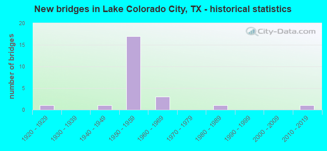
- New bridges - historical statistics
- 11920-1929
- 11940-1949
- 171950-1959
- 31960-1969
- 11980-1989
- 12010-2019


- Bridge Condition - Deck
- 42.9%Good
- 50.0%Satisfactory
- 7.1%Fair

- Bridge Condition - Superstructure
- 7.1%Very good
- 28.6%Good
- 42.9%Satisfactory
- 21.4%Fair

- Bridge Condition - Substructure
- 7.1%Very good
- 35.7%Good
- 42.9%Satisfactory
- 14.3%Fair

- Bridge Condition - Channel
- 10.0%Very good
- 60.0%Good
- 30.0%Satisfactory

- Bridge Condition - Culverts
- 66.7%Good
- 33.3%Satisfactory
Find on map >> Show street view
Structure Number: 81680000508012, Location: 5.7 MI W OF SH 208 (Lat: 32.388186, Lng: -100.950164), Route carried "on" structure: Interstate 20, Year Built: 1928, Year Reconstructed: 1988, Status: Open, Structure Length: 9.14m (29.99ft), Average Daily Traffic: 11,167 (year 2019), Truck Traffic: 45%, Average Future Daily Traffic: 7,780 (year 2033), Design Load: H 15, Features Intersected: MORGAN CREEK
Minimum Vertical Clearance: 30+ m (98+ ft), Kilometerpoint: 24.591, Lanes on structure: 2, Base Highway Network: Yes, Owner: State Highway Agency, Approaching Roadway Width: 11.6m (38.1ft), Material/Design: Concrete, Design/Construction: Tee Beam, Number Of Spans In Main Unit: 3, Number Of Approach Spans: 6, Length of Maximum Span: 13.1m (43.0ft), Curb-To-Curb Width: 11.6m (38.1ft), Out-to-Out Width: 12.2m (40.0ft)
Condition: Deck: Satisfactory, Superstructure: Fair, Substructure: Satisfactory, Channel: Good, Operating Rating: 50.8 metric tons, Method Used To Determine Operating Rating: Load Factor (LF), Inventory Rating: 29.9 metric tons, Method Used To Determine Inventory Rating: Load Factor (LF), Structural Evaluation: Somewhat better than minimum adequacy, Deck Geometry: Equal to present minimum criteria, Waterway Adequacy: Superior to present desirable criteria, Approach Roadway Alignment: Equal to present desirable criteria, Length Of Structure Improvement: 9.14m (29.99ft), Designated Inspection Frequency: Every 24 months, Inspection Date: May 2021, Bridge Improvement Cost: $342,000, Roadway Improvement Cost: $86,000, Total Project Cost: $428,000, Deck Structure Type: Concrete Cast-file-Place, Wearing Surface/Protective System: Wearing Surface: Bituminous
Find on map >> Show street view
Structure Number: 81680000508052, Location: 2.6 MI E OF FM 670(N) (Lat: 32.376147, Lng: -100.976228), Route carried "on" structure: Interstate 20, Year Built: 1957, Status: Open, Structure Length: 3.47m (11.38ft), Average Daily Traffic: 6,190 (year 2013), Truck Traffic: 46%, Average Future Daily Traffic: 8,660 (year 2033), Design Load: HS 20, Features Intersected: DORN RD
Minimum Vertical Clearance: 30+ m (98+ ft), Kilometerpoint: 21.773, Lanes on structure: 2, Lanes under structure: 2, Base Highway Network: Yes, Owner: State Highway Agency, Approaching Roadway Width: 11.6m (38.1ft), Material/Design: Concrete continuous, Design/Construction: Slab, Number Of Spans In Main Unit: 3, Length of Maximum Span: 13.7m (44.9ft), Curb-To-Curb Width: 11.6m (38.1ft), Out-to-Out Width: 12.2m (40.0ft)
Condition: Deck: Satisfactory, Superstructure: Satisfactory, Substructure: Good, Operating Rating: 39.0 metric tons, Method Used To Determine Operating Rating: Load Factor (LF), Inventory Rating: 23.6 metric tons, Method Used To Determine Inventory Rating: Load Factor (LF), Structural Evaluation: Somewhat better than minimum adequacy, Deck Geometry: Equal to present minimum criteria, Underclear: Somewhat better than minimum adequacy, Approach Roadway Alignment: Equal to present desirable criteria, Designated Inspection Frequency: Every 24 months, Inspection Date: May 2021, Deck Structure Type: Concrete Cast-file-Place, Wearing Surface/Protective System: Wearing Surface: Bituminous
Find on map >> Show street view
Structure Number: 81680000508053, Location: 2.6 MI E OF FM 670(N) (Lat: 32.376011, Lng: -100.976092), Route carried "on" structure: Interstate 20, Year Built: 1957, Status: Open, Structure Length: 3.47m (11.38ft), Average Daily Traffic: 6,190 (year 2013), Truck Traffic: 46%, Average Future Daily Traffic: 8,660 (year 2033), Design Load: HS 20, Features Intersected: DORN RD
Minimum Vertical Clearance: 30+ m (98+ ft), Kilometerpoint: 21.773, Lanes on structure: 2, Lanes under structure: 2, Base Highway Network: Yes, Owner: State Highway Agency, Approaching Roadway Width: 11.6m (38.1ft), Material/Design: Concrete continuous, Design/Construction: Slab, Number Of Spans In Main Unit: 3, Length of Maximum Span: 13.7m (44.9ft), Curb-To-Curb Width: 11.6m (38.1ft), Out-to-Out Width: 12.2m (40.0ft)
Condition: Deck: Good, Superstructure: Good, Substructure: Good, Operating Rating: 39.9 metric tons, Method Used To Determine Operating Rating: Load Factor (LF), Inventory Rating: 23.6 metric tons, Method Used To Determine Inventory Rating: Load Factor (LF), Structural Evaluation: Somewhat better than minimum adequacy, Deck Geometry: Equal to present minimum criteria, Underclear: Somewhat better than minimum adequacy, Approach Roadway Alignment: Equal to present desirable criteria, Designated Inspection Frequency: Every 24 months, Inspection Date: May 2021, Deck Structure Type: Concrete Cast-file-Place, Wearing Surface/Protective System: Wearing Surface: Bituminous
Find on map >> Show street view
Structure Number: 81680000508054, Location: 8.3 MI W OF SH 208 (Lat: 32.385742, Lng: -100.961092), Route carried "on" structure: Interstate 20, Year Built: 1957, Status: Open, Structure Length: 3.47m (11.38ft), Average Daily Traffic: 6,190 (year 2013), Truck Traffic: 46%, Average Future Daily Traffic: 8,660 (year 2033), Design Load: HS 20, Features Intersected: FM 2836
Minimum Vertical Clearance: 30+ m (98+ ft), Kilometerpoint: 23.570, Lanes on structure: 2, Lanes under structure: 2, Base Highway Network: Yes, Owner: State Highway Agency, Approaching Roadway Width: 11.6m (38.1ft), Material/Design: Concrete continuous, Design/Construction: Slab, Number Of Spans In Main Unit: 3, Length of Maximum Span: 13.7m (44.9ft), Curb-To-Curb Width: 11.6m (38.1ft), Out-to-Out Width: 12.2m (40.0ft)
Condition: Deck: Satisfactory, Superstructure: Satisfactory, Substructure: Satisfactory, Operating Rating: 39.9 metric tons, Method Used To Determine Operating Rating: Load Factor (LF), Inventory Rating: 23.6 metric tons, Method Used To Determine Inventory Rating: Load Factor (LF), Structural Evaluation: Somewhat better than minimum adequacy, Deck Geometry: Equal to present minimum criteria, Underclear: Somewhat better than minimum adequacy, Approach Roadway Alignment: Equal to present desirable criteria, Designated Inspection Frequency: Every 24 months, Inspection Date: May 2021, Deck Structure Type: Concrete Cast-file-Place, Wearing Surface/Protective System: Wearing Surface: Bituminous
Find on map >> Show street view
Structure Number: 81680000508055, Location: 8.3 MI W OF SH 208 (Lat: 32.385594, Lng: -100.960944), Route carried "on" structure: Interstate 20, Year Built: 1957, Status: Open, Structure Length: 3.47m (11.38ft), Average Daily Traffic: 11,167 (year 2019), Truck Traffic: 46%, Average Future Daily Traffic: 8,660 (year 2033), Design Load: HS 20, Features Intersected: FM 2836
Minimum Vertical Clearance: 30+ m (98+ ft), Kilometerpoint: 23.570, Lanes on structure: 2, Lanes under structure: 2, Base Highway Network: Yes, Owner: State Highway Agency, Approaching Roadway Width: 11.6m (38.1ft), Material/Design: Concrete continuous, Design/Construction: Slab, Number Of Spans In Main Unit: 3, Length of Maximum Span: 13.7m (44.9ft), Curb-To-Curb Width: 11.6m (38.1ft), Out-to-Out Width: 12.2m (40.0ft)
Condition: Deck: Satisfactory, Superstructure: Satisfactory, Substructure: Good, Operating Rating: 39.0 metric tons, Method Used To Determine Operating Rating: Load Factor (LF), Inventory Rating: 22.7 metric tons, Method Used To Determine Inventory Rating: Load Factor (LF), Structural Evaluation: Somewhat better than minimum adequacy, Deck Geometry: Equal to present minimum criteria, Underclear: Meets minimum limits, Approach Roadway Alignment: Equal to present desirable criteria, Designated Inspection Frequency: Every 24 months, Inspection Date: May 2021, Deck Structure Type: Concrete Cast-file-Place, Wearing Surface/Protective System: Wearing Surface: Bituminous
Find on map >> Show street view
Structure Number: 81680000508056, Location: 5.7 MI W OF SH 208 (Lat: 32.388547, Lng: -100.950056), Route carried "on" structure: ServiceInterstate 20, Year Built: 1957, Status: Open, Structure Length: 9.75m (31.99ft), Average Daily Traffic: 260 (year 2013), Truck Traffic: 46%, Average Future Daily Traffic: 360 (year 2033), Features Intersected: MORGAN CREEK
Minimum Vertical Clearance: 30+ m (98+ ft), Kilometerpoint: 24.591, Lanes on structure: 2, Owner: State Highway Agency, Approaching Roadway Width: 6.7m (22.0ft), Material/Design: Concrete, Design/Construction: Stringer/Multi-beam, Number Of Spans In Main Unit: 8, Length of Maximum Span: 12.2m (40.0ft), Curb-To-Curb Width: 7.3m (24.0ft), Out-to-Out Width: 7.8m (25.6ft)
Condition: Deck: Good, Superstructure: Good, Substructure: Satisfactory, Channel: Good, Operating Rating: 43.5 metric tons, Method Used To Determine Operating Rating: Load Factor (LF), Inventory Rating: 26.3 metric tons, Method Used To Determine Inventory Rating: Load Factor (LF), Structural Evaluation: Equal to present minimum criteria, Deck Geometry: Somewhat better than minimum adequacy, Waterway Adequacy: Superior to present desirable criteria, Approach Roadway Alignment: Equal to present desirable criteria, Length Of Structure Improvement: 9.75m (31.99ft), Designated Inspection Frequency: Every 24 months, Inspection Date: May 2021, Bridge Improvement Cost: $231,000, Roadway Improvement Cost: $59,000, Total Project Cost: $290,000, Deck Structure Type: Concrete Cast-file-Place, Wearing Surface/Protective System: Wearing Surface: Bituminous
Find on map >> Show street view
Structure Number: 81680000508057, Location: 5.7 MI W OF SH 208 (Lat: 32.388383, Lng: -100.950103), Route carried "on" structure: Interstate 20, Year Built: 1957, Status: Open, Structure Length: 9.75m (31.99ft), Average Daily Traffic: 10,851 (year 2019), Truck Traffic: 45%, Average Future Daily Traffic: 7,780 (year 2033), Features Intersected: MORGAN CREEK
Minimum Vertical Clearance: 30+ m (98+ ft), Kilometerpoint: 24.591, Lanes on structure: 2, Base Highway Network: Yes, Owner: State Highway Agency, Approaching Roadway Width: 12.5m (41.0ft), Material/Design: Concrete, Design/Construction: Stringer/Multi-beam, Number Of Spans In Main Unit: 8, Length of Maximum Span: 12.2m (40.0ft), Curb-To-Curb Width: 12.4m (40.7ft), Out-to-Out Width: 13.0m (42.7ft)
Condition: Deck: Satisfactory, Superstructure: Fair, Substructure: Satisfactory, Channel: Satisfactory, Operating Rating: 51.7 metric tons, Method Used To Determine Operating Rating: Load Factor (LF), Inventory Rating: 30.8 metric tons, Method Used To Determine Inventory Rating: Load Factor (LF), Structural Evaluation: Somewhat better than minimum adequacy, Deck Geometry: Better than present minimum criteria, Waterway Adequacy: Superior to present desirable criteria, Approach Roadway Alignment: Equal to present desirable criteria, Designated Inspection Frequency: Every 24 months, Inspection Date: May 2021, Deck Structure Type: Concrete Cast-file-Place, Wearing Surface/Protective System: Wearing Surface: Bituminous
Find on map >> Show street view
Structure Number: 81680000508058, Location: 5.7 MI W OF SH 208 (Lat: 32.388036, Lng: -100.950128), Route carried "on" structure: ServiceInterstate 20, Year Built: 1957, Status: Open, Structure Length: 9.75m (31.99ft), Average Daily Traffic: 160 (year 2013), Truck Traffic: 42%, Average Future Daily Traffic: 230 (year 2033), Features Intersected: MORGAN CREEK
Minimum Vertical Clearance: 30+ m (98+ ft), Kilometerpoint: 24.591, Lanes on structure: 2, Owner: State Highway Agency, Approaching Roadway Width: 6.4m (21.0ft), Material/Design: Concrete, Design/Construction: Stringer/Multi-beam, Number Of Spans In Main Unit: 8, Length of Maximum Span: 12.2m (40.0ft), Curb-To-Curb Width: 7.3m (24.0ft), Out-to-Out Width: 7.8m (25.6ft)
Condition: Deck: Good, Superstructure: Good, Substructure: Fair, Channel: Good, Operating Rating: 43.5 metric tons, Method Used To Determine Operating Rating: Load Factor (LF), Inventory Rating: 26.3 metric tons, Method Used To Determine Inventory Rating: Load Factor (LF), Structural Evaluation: Somewhat better than minimum adequacy, Deck Geometry: Somewhat better than minimum adequacy, Waterway Adequacy: Superior to present desirable criteria, Approach Roadway Alignment: Equal to present desirable criteria, Length Of Structure Improvement: 9.75m (31.99ft), Designated Inspection Frequency: Every 24 months, Inspection Date: May 2021, Bridge Improvement Cost: $231,000, Roadway Improvement Cost: $59,000, Total Project Cost: $290,000, Deck Structure Type: Concrete Cast-file-Place, Wearing Surface/Protective System: Wearing Surface: Bituminous
Find on map >> Show street view
Structure Number: 81680000508059, Location: 4.3 MI W OF SH 208 (Lat: 32.392181, Lng: -100.927333), Route carried "on" structure: Interstate 20, Year Built: 1957, Status: Open, Structure Length: 3.47m (11.38ft), Average Daily Traffic: 10,960 (year 2019), Truck Traffic: 45%, Average Future Daily Traffic: 7,780 (year 2033), Design Load: HS 20, Features Intersected: FM 1229
Minimum Vertical Clearance: 30+ m (98+ ft), Kilometerpoint: 26.828, Lanes on structure: 2, Lanes under structure: 2, Base Highway Network: Yes, Owner: State Highway Agency, Approaching Roadway Width: 11.6m (38.1ft), Material/Design: Concrete continuous, Design/Construction: Slab, Number Of Spans In Main Unit: 3, Length of Maximum Span: 13.7m (44.9ft), Curb-To-Curb Width: 11.6m (38.1ft), Out-to-Out Width: 12.2m (40.0ft)
Condition: Deck: Satisfactory, Superstructure: Satisfactory, Substructure: Good, Operating Rating: 39.0 metric tons, Method Used To Determine Operating Rating: Assigned ratings based on Allowable Stress Design (ASD) reported in metric tons, Inventory Rating: 23.6 metric tons, Method Used To Determine Inventory Rating: Assigned ratings based on Allowable Stress Design (ASD) reported in metric tons, Structural Evaluation: Somewhat better than minimum adequacy, Deck Geometry: Equal to present minimum criteria, Underclear: Meets minimum limits, Approach Roadway Alignment: Equal to present desirable criteria, Designated Inspection Frequency: Every 24 months, Inspection Date: May 2021, Deck Structure Type: Concrete Cast-file-Place, Wearing Surface/Protective System: Wearing Surface: Bituminous
Find on map >> Show street view
Structure Number: 8168000050806, Location: 4.3 MI W OF SH 208 (Lat: 32.392006, Lng: -100.927289), Route carried "on" structure: Interstate 20, Year Built: 1957, Status: Open, Structure Length: 3.47m (11.38ft), Average Daily Traffic: 11,253 (year 2019), Truck Traffic: 45%, Average Future Daily Traffic: 7,780 (year 2033), Design Load: HS 20, Features Intersected: FM 1229
Minimum Vertical Clearance: 30+ m (98+ ft), Kilometerpoint: 26.828, Lanes on structure: 2, Lanes under structure: 2, Base Highway Network: Yes, Owner: State Highway Agency, Approaching Roadway Width: 11.6m (38.1ft), Material/Design: Concrete continuous, Design/Construction: Slab, Number Of Spans In Main Unit: 3, Length of Maximum Span: 13.7m (44.9ft), Curb-To-Curb Width: 11.6m (38.1ft), Out-to-Out Width: 12.2m (40.0ft)
Condition: Deck: Satisfactory, Superstructure: Satisfactory, Substructure: Good, Operating Rating: 39.0 metric tons, Method Used To Determine Operating Rating: Assigned ratings based on Allowable Stress Design (ASD) reported in metric tons, Inventory Rating: 23.6 metric tons, Method Used To Determine Inventory Rating: Assigned ratings based on Allowable Stress Design (ASD) reported in metric tons, Structural Evaluation: Somewhat better than minimum adequacy, Deck Geometry: Equal to present minimum criteria, Underclear: High priority of corrective action, Approach Roadway Alignment: Equal to present desirable criteria, Designated Inspection Frequency: Every 24 months, Inspection Date: May 2021, Deck Structure Type: Concrete Cast-file-Place, Wearing Surface/Protective System: Wearing Surface: Bituminous
Find on map >> Show street view
Structure Number: 81680000508093, Location: 1.0 MI E OF FM 1229 (Lat: 32.393028, Lng: -100.907033), Route carried "on" structure: State highway 20, Year Built: 1962, Status: Open, Structure Length: 12.19m (39.99ft), Average Daily Traffic: 480 (year 2010), Truck Traffic: 10%, Average Future Daily Traffic: 670 (year 2030), Design Load: HS 20, Features Intersected: IH 20
Minimum Vertical Clearance: 30+ m (98+ ft), Kilometerpoint: 1.238, Lanes on structure: 2, Lanes under structure: 4, Owner: State Highway Agency, Approaching Roadway Width: 8.5m (27.9ft), Skew: 5 degrees, Material/Design: Steel continuous, Design/Construction: Stringer/Multi-beam, Number Of Spans In Main Unit: 4, Length of Maximum Span: 30.5m (100.1ft), Curb-To-Curb Width: 8.4m (27.6ft), Out-to-Out Width: 9.5m (31.2ft)
Condition: Deck: Fair, Superstructure: Fair, Substructure: Fair, Operating Rating: 49.0 metric tons, Method Used To Determine Operating Rating: Load Factor (LF), Inventory Rating: 29.0 metric tons, Method Used To Determine Inventory Rating: Load Factor (LF), Structural Evaluation: Somewhat better than minimum adequacy, Deck Geometry: Somewhat better than minimum adequacy, Underclear: Equal to present minimum criteria, Approach Roadway Alignment: Equal to present desirable criteria, Length Of Structure Improvement: 12.25m (40.19ft), Designated Inspection Frequency: Every 24 months, Inspection Date: May 2021, Deck Structure Type: Concrete Cast-file-Place, Wearing Surface/Protective System: Wearing Surface: Bituminous
Find on map >> Show street view
Structure Number: 81680033301004, Location: 2.8 MI S OF FM 1229 (Lat: 32.316069, Lng: -100.917969), Route carried "on" structure: State highway 163, Year Built: 1949, Year Reconstructed: 1989, Status: Open, Structure Length: 6.16m (20.21ft), Average Daily Traffic: 1,280 (year 2013), Truck Traffic: 35%, Average Future Daily Traffic: 1,790 (year 2033), Features Intersected: MORGAN CREEK
Minimum Vertical Clearance: 30+ m (98+ ft), Kilometerpoint: 10.252, Lanes on structure: 2, Base Highway Network: Yes, Owner: State Highway Agency, Approaching Roadway Width: 12.2m (40.0ft), Material/Design: Steel, Design/Construction: Stringer/Multi-beam, Number Of Spans In Main Unit: 5, Length of Maximum Span: 12.2m (40.0ft), Curb-To-Curb Width: 12.1m (39.7ft), Out-to-Out Width: 12.8m (42.0ft)
Condition: Deck: Good, Superstructure: Satisfactory, Substructure: Satisfactory, Channel: Satisfactory, Operating Rating: 35.4 metric tons, Method Used To Determine Operating Rating: Load Factor (LF), Inventory Rating: 20.9 metric tons, Method Used To Determine Inventory Rating: Load Factor (LF), Structural Evaluation: Somewhat better than minimum adequacy, Deck Geometry: Equal to present minimum criteria, Waterway Adequacy: Superior to present desirable criteria, Approach Roadway Alignment: Equal to present desirable criteria, Designated Inspection Frequency: Every 24 months, Inspection Date: May 2021, Deck Structure Type: Concrete Cast-file-Place, Wearing Surface/Protective System: Wearing Surface: Bituminous
Find on map >> Show street view
Structure Number: 81680033301006, Location: 1.5 MI S OF FM 2836 (Lat: 32.297256, Lng: -100.940636), Route carried "on" structure: State highway 163, Year Built: 1950, Status: Open, Structure Length: 3.05m (10.01ft), Average Daily Traffic: 224 (year 2020), Truck Traffic: 38%, Average Future Daily Traffic: 1,050 (year 2033), Design Load: H 15, Features Intersected: CAMP CREEK
Minimum Vertical Clearance: 30+ m (98+ ft), Kilometerpoint: 13.317, Lanes on structure: 2, Owner: State Highway Agency, Approaching Roadway Width: 7.3m (24.0ft), Material/Design: Concrete, Design/Construction: Slab, Number Of Spans In Main Unit: 4, Length of Maximum Span: 7.6m (24.9ft), Curb-To-Curb Width: 7.2m (23.6ft), Out-to-Out Width: 7.7m (25.3ft)
Condition: Deck: Good, Superstructure: Good, Substructure: Satisfactory, Channel: Good, Operating Rating: 48.1 metric tons, Method Used To Determine Operating Rating: Load Factor (LF), Inventory Rating: 24.5 metric tons, Method Used To Determine Inventory Rating: Load Factor (LF), Structural Evaluation: Equal to present minimum criteria, Deck Geometry: Meets minimum limits, Waterway Adequacy: Equal to present minimum criteria, Approach Roadway Alignment: Equal to present desirable criteria, Designated Inspection Frequency: Every 24 months, Inspection Date: May 2021, Deck Structure Type: Concrete Cast-file-Place, Wearing Surface/Protective System: Wearing Surface: Bituminous
Find on map >> Show street view
Structure Number: 81680033301007, Location: 2.7 MI S OF FM 2836 (Lat: 32.282569, Lng: -100.948361), Route carried "on" structure: State highway 163, Year Built: 1950, Status: Open, Structure Length: 1.01m (3.31ft), Average Daily Traffic: 224 (year 2020), Truck Traffic: 38%, Average Future Daily Traffic: 1,050 (year 2033), Features Intersected: CAMP CREEK DRAW
Minimum Vertical Clearance: 30+ m (98+ ft), Kilometerpoint: 15.110, Lanes on structure: 2, Owner: State Highway Agency, Approaching Roadway Width: 9.8m (32.2ft), Material/Design: Concrete, Design/Construction: Culvert, Number Of Spans In Main Unit: 6, Length of Maximum Span: 1.5m (4.9ft), Curb-To-Curb Width: 9.8m (32.2ft), Out-to-Out Width: 13.2m (43.3ft)
Condition: Channel: Good, Culverts: Satisfactory, Operating Rating: 39.9 metric tons, Method Used To Determine Operating Rating: Load Factor (LF), Inventory Rating: 23.6 metric tons, Method Used To Determine Inventory Rating: Load Factor (LF), Structural Evaluation: Equal to present minimum criteria, Deck Geometry: Better than present minimum criteria, Waterway Adequacy: Equal to present minimum criteria, Approach Roadway Alignment: Equal to present desirable criteria, Designated Inspection Frequency: Every 24 months, Inspection Date: May 2021, Deck Structure Type: Concrete Cast-file-Place, Wearing Surface/Protective System: Wearing Surface: Bituminous
Find on map >> Show street view
Structure Number: 81680136202002, Location: 1.4 MI NW OF SH 163 (Lat: 32.359311, Lng: -100.918864), Route carried "on" structure: State highway 1229, Year Built: 1963, Status: Open, Structure Length: 0.82m (2.69ft), Average Daily Traffic: 100 (year 2020), Truck Traffic: 22%, Average Future Daily Traffic: 130 (year 2033), Design Load: HS 20, Features Intersected: DRAW
Minimum Vertical Clearance: 30+ m (98+ ft), Kilometerpoint: 28.939, Lanes on structure: 2, Owner: State Highway Agency, Approaching Roadway Width: 6.1m (20.0ft), Skew: 4 degrees, Material/Design: Concrete, Design/Construction: Culvert, Number Of Spans In Main Unit: 3, Length of Maximum Span: 1.8m (5.9ft), Curb-To-Curb Width: 6.1m (20.0ft), Out-to-Out Width: 12.0m (39.4ft)
Condition: Channel: Good, Culverts: Good, Operating Rating: 39.9 metric tons, Method Used To Determine Operating Rating: Load Factor (LF), Inventory Rating: 23.6 metric tons, Method Used To Determine Inventory Rating: Load Factor (LF), Structural Evaluation: Equal to present minimum criteria, Deck Geometry: Somewhat better than minimum adequacy, Waterway Adequacy: Equal to present minimum criteria, Approach Roadway Alignment: Equal to present desirable criteria, Designated Inspection Frequency: Every 24 months, Inspection Date: May 2021, Deck Structure Type: Concrete Cast-file-Place, Wearing Surface/Protective System: Wearing Surface: Bituminous
Find on map >> Show street view
Structure Number: 81680203403004, Location: 1.3 MI N OF SH 350 (Lat: 32.521014, Lng: -101.138931), Route carried "on" structure: State highway 1298, Year Built: 1985, Status: Open, Structure Length: 0.67m (2.20ft), Average Daily Traffic: 100 (year 2020), Truck Traffic: 21%, Average Future Daily Traffic: 110 (year 2033), Design Load: H 20, Features Intersected: WILLOW CREEK
Minimum Vertical Clearance: 30+ m (98+ ft), Kilometerpoint: 0.779, Lanes on structure: 2, Owner: State Highway Agency, Approaching Roadway Width: 6.1m (20.0ft), Material/Design: Concrete, Design/Construction: Culvert, Number Of Spans In Main Unit: 2, Length of Maximum Span: 3.0m (9.8ft), Curb-To-Curb Width: 9.8m (32.2ft), Out-to-Out Width: 10.2m (33.5ft)
Condition: Channel: Satisfactory, Culverts: Good, Operating Rating: 39.9 metric tons, Method Used To Determine Operating Rating: Load Factor (LF), Inventory Rating: 23.6 metric tons, Method Used To Determine Inventory Rating: Load Factor (LF), Structural Evaluation: Equal to present minimum criteria, Deck Geometry: Equal to present desirable criteria, Waterway Adequacy: Equal to present minimum criteria, Approach Roadway Alignment: Equal to present desirable criteria, Designated Inspection Frequency: Every 48 months, Inspection Date: May 2019, Deck Structure Type: Concrete Cast-file-Place, Wearing Surface/Protective System: Wearing Surface: Bituminous
Find on map >> Show street view
Structure Number: 81680233101056, Location: 2.3 MI S OF IH 20 (Lat: 32.357533, Lng: -100.953389), Route carried "on" structure: State highway 2836, Year Built: 2016, Status: Open, Structure Length: 4.15m (13.62ft), Average Daily Traffic: 273 (year 2020), Truck Traffic: 10%, Average Future Daily Traffic: 1,000 (year 2034), Design Load: HL 93, Features Intersected: Cherry Creek
Minimum Vertical Clearance: 30+ m (98+ ft), Kilometerpoint: 4.783, Lanes on structure: 2, Owner: State Highway Agency, Approaching Roadway Width: 6.7m (22.0ft), Material/Design: Prestressed concrete, Design/Construction: Box Beam or Girders - Multiple, Number Of Spans In Main Unit: 1, Number Of Approach Spans: 1, Length of Maximum Span: 27.4m (89.9ft), Curb-To-Curb Width: 10.7m (35.1ft), Out-to-Out Width: 11.7m (38.4ft)
Condition: Deck: Good, Superstructure: Very good, Substructure: Very good, Channel: Very good, Operating Rating: 54.4 metric tons, Method Used To Determine Operating Rating: Assigned ratings based on Load and Resistance Factor Design (LRFD) reported in metric tons, Inventory Rating: 32.7 metric tons, Method Used To Determine Inventory Rating: Assigned ratings based on Load and Resistance Factor Design (LRFD) reported in metric tons, Structural Evaluation: Equal to present desirable criteria, Deck Geometry: Better than present minimum criteria, Waterway Adequacy: Superior to present desirable criteria, Approach Roadway Alignment: Equal to present desirable criteria, Designated Inspection Frequency: Every 24 months, Inspection Date: May 2021, Deck Structure Type: Concrete Cast-file-Place, Wearing Surface/Protective System: Deck Protection: Epoxy Coated Reinforcing
Find on map >> Show street view
Structure Number: 81680000508052, Location: 2.6 MI E OF FM 670(N) (Lat: 32.376147, Lng: -100.976228), Route carried "under" structure: County highway , Year Built: 1957, Structure Length: 0. m, Average Daily Traffic: 50 (year 2011), Truck Traffic: 2%, Features Intersected: Dorn Rd, Facility Carried by Structure: IH 20 WB
Minimum Vertical Clearance: 4.50m (14.76ft), Kilometerpoint: 21.773, Lanes on structure: 2, Lanes under structure: 2, Material/Design: Concrete continuous, Design/Construction: Slab, Length of Maximum Span: 13.7m (44.9ft)
Find on map >> Show street view
Structure Number: 81680000508053, Location: 2.6 MI E OF FM 670(N) (Lat: 32.376011, Lng: -100.976092), Route carried "under" structure: County highway , Year Built: 1957, Structure Length: 0. m, Average Daily Traffic: 50 (year 2011), Truck Traffic: 2%, Features Intersected: Dorn Rd, Facility Carried by Structure: IH 20 EB
Minimum Vertical Clearance: 4.50m (14.76ft), Kilometerpoint: 21.773, Lanes on structure: 2, Lanes under structure: 2, Material/Design: Concrete continuous, Design/Construction: Slab, Length of Maximum Span: 13.7m (44.9ft)
Find on map >> Show street view
Structure Number: 81680000508054, Location: 8.3 MI W OF SH 208 (Lat: 32.385742, Lng: -100.961092), Route carried "under" structure: State highway 2836, Year Built: 1957, Structure Length: 0. m, Average Daily Traffic: 860 (year 2013), Truck Traffic: 24%, Features Intersected: FM 2836, Facility Carried by Structure: IH 20 WB
Minimum Vertical Clearance: 4.60m (15.09ft), Kilometerpoint: 1.600, Lanes on structure: 2, Lanes under structure: 2, Material/Design: Concrete continuous, Design/Construction: Slab, Length of Maximum Span: 13.7m (44.9ft)
Find on map >> Show street view
Structure Number: 81680000508055, Location: 8.3 MI W OF SH 208 (Lat: 32.385594, Lng: -100.960944), Route carried "under" structure: State highway 2836, Year Built: 1957, Structure Length: 0. m, Average Daily Traffic: 860 (year 2013), Truck Traffic: 24%, Features Intersected: FM 2836, Facility Carried by Structure: IH 20 EB
Minimum Vertical Clearance: 4.55m (14.93ft), Kilometerpoint: 1.617, Lanes on structure: 2, Lanes under structure: 2, Material/Design: Concrete continuous, Design/Construction: Slab, Length of Maximum Span: 13.7m (44.9ft)
Find on map >> Show street view
Structure Number: 81680000508059, Location: 4.3 MI W OF SH 208 (Lat: 32.392181, Lng: -100.927333), Route carried "under" structure: State highway 1229, Year Built: 1957, Structure Length: 0. m, Average Daily Traffic: 320 (year 2013), Truck Traffic: 24%, Features Intersected: FM 1229, Facility Carried by Structure: IH 20 WB
Minimum Vertical Clearance: 4.57m (14.99ft), Kilometerpoint: 25.173, Lanes on structure: 2, Lanes under structure: 2, Material/Design: Concrete continuous, Design/Construction: Slab, Length of Maximum Span: 13.7m (44.9ft)
Find on map >> Show street view
Structure Number: 8168000050806, Location: 4.3 MI W OF SH 208 (Lat: 32.392006, Lng: -100.927289), Route carried "under" structure: State highway 1229, Year Built: 1957, Structure Length: 0. m, Average Daily Traffic: 320 (year 2013), Truck Traffic: 24%, Features Intersected: FM 1229, Facility Carried by Structure: IH 20 EB
Minimum Vertical Clearance: 4.42m (14.50ft), Kilometerpoint: 25.191, Lanes on structure: 2, Lanes under structure: 2, Material/Design: Concrete continuous, Design/Construction: Slab, Length of Maximum Span: 13.7m (44.9ft)
Find on map >> Show street view
Structure Number: 81680000508093, Location: 1.0 MI E OF FM 1229 (Lat: 32.393028, Lng: -100.907033), Route carried "under" structure: Interstate 20, Year Built: 1962, Structure Length: 0. m, Average Daily Traffic: 14,060 (year 2010), Truck Traffic: 45%, Features Intersected: IH 20
Minimum Vertical Clearance: 5.44m (17.85ft), Kilometerpoint: 28.757, Lanes on structure: 2, Lanes under structure: 4, Material/Design: Steel continuous, Design/Construction: Stringer/Multi-beam, Length of Maximum Span: 30.5m (100.1ft)