Bridge Statistics for Lake Forest, Illinois (IL)
Condition, Traffic, Stress, Structural Evaluation, Project Costs
- National Bridge Inventory (NBI) Statistics
- 24Number of bridges
- 167ft / 50.5mTotal length
- $1,722,000Total costs
- 234,950Total average daily traffic
- 13,838Total average daily truck traffic
- National Bridge Inventory (NBI) Registered Bridges for Lake Forest
- No street view available for this location
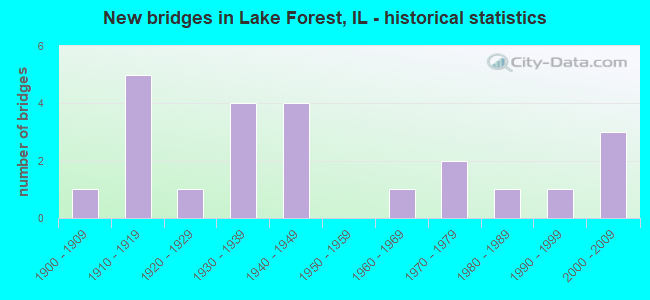
- New bridges - historical statistics
- 11900-1909
- 51910-1919
- 11920-1929
- 41930-1939
- 41940-1949
- 11960-1969
- 21970-1979
- 11980-1989
- 11990-1999
- 32000-2009

- Reconstructed bridges - Historical Statistics
- 11940-1949
- 01950-1959
- 01960-1969
- 11970-1979
- 21980-1989
- 41990-1999


- Bridge Condition - Deck
- 15.4%Very good
- 61.5%Good
- 7.7%Satisfactory
- 15.4%Fair

- Bridge Condition - Superstructure
- 26.7%Very good
- 33.3%Good
- 13.3%Satisfactory
- 13.3%Fair
- 13.3%Poor

- Bridge Condition - Substructure
- 33.3%Very good
- 33.3%Good
- 13.3%Satisfactory
- 13.3%Fair
- 6.7%Poor

- Bridge Condition - Channel
- 20.0%Very good
- 33.3%Good
- 33.3%Satisfactory
- 13.3%Poor
Find on map >> Show street view
Structure Number: 490037, Location: 0.4 M W OF IL 43 (Lat: 42.240006, Lng: -87.880642), Route carried "on" structure: State highway 60, Year Built: 1941, Year Reconstructed: 1987, Status: Open, Structure Length: 1.24m (4.07ft), Average Daily Traffic: 19,000 (year 2021), Truck Traffic: 5%, Average Future Daily Traffic: 26,712 (year 2032), Design Load: H 20, Features Intersected: MD FK N BR CHICAGO R
Minimum Vertical Clearance: 30+ m (98+ ft), Kilometerpoint: 26.344, Lanes on structure: 4, Base Highway Network: Yes, Owner: State Highway Agency, Approaching Roadway Width: 14.6m (47.9ft), Material/Design: Steel, Design/Construction: Stringer/Multi-beam, Number Of Spans In Main Unit: 1, Length of Maximum Span: 11.6m (38.1ft), Curb or Sidewalk Widths: Left: 1.5m (4.9ft), Right: 0.0m, Curb-To-Curb Width: 15.2m (49.9ft), Out-to-Out Width: 17.6m (57.7ft)
Condition: Deck: Good, Superstructure: Good, Substructure: Very good, Channel: Very good, Operating Rating: 63.5 metric tons, Method Used To Determine Operating Rating: Load Factor (LF) rating reported by rating factor (RF) method using MS18 loading, Inventory Rating: 37.9 metric tons, Method Used To Determine Inventory Rating: Load Factor (LF) rating reported by rating factor (RF) method using MS18 loading, Structural Evaluation: Better than present minimum criteria, Deck Geometry: High priority of corrective action, Waterway Adequacy: Equal to present minimum criteria, Approach Roadway Alignment: Equal to present minimum criteria, Length Of Structure Improvement: 1.86m (6.10ft), Designated Inspection Frequency: Every 24 months, Inspection Date: August 2020, Bridge Improvement Cost: $361,000, Roadway Improvement Cost: $36,000, Total Project Cost: $542,000, Deck Structure Type: Concrete Cast-file-Place, Wearing Surface/Protective System: Wearing Surface: Latex Concrete, Deck Protection: Epoxy Coated Reinforcing
Find on map >> Show street view
Structure Number: 490183, Location: 0.1 M S DEERPATH RD (Lat: 42.252314, Lng: -87.831592), Route carried "on" structure: Other road , Year Built: 2002, Status: Open, Structure Length: 3.17m (10.40ft), Average Daily Traffic: 4,000 (year 2019), Truck Traffic: 11%, Average Future Daily Traffic: 3,506 (year 2032), Features Intersected: SMALL STREAM, Facility Carried by Structure: SHERIDAN RD
Minimum Vertical Clearance: 30+ m (98+ ft), Kilometerpoint: 2.736, Lanes on structure: 2, Owner: City or Municipal Highway Agency, Approaching Roadway Width: 7.6m (24.9ft), Material/Design: Prestressed concrete continuous, Design/Construction: Stringer/Multi-beam, Number Of Spans In Main Unit: 3, Length of Maximum Span: 9.4m (30.8ft), Curb-To-Curb Width: 11.0m (36.1ft), Out-to-Out Width: 14.6m (47.9ft)
Condition: Deck: Good, Superstructure: Good, Substructure: Very good, Channel: Good, Operating Rating: 89.1 metric tons, Method Used To Determine Operating Rating: Load Factor (LF) rating reported by rating factor (RF) method using MS18 loading, Inventory Rating: 63.5 metric tons, Method Used To Determine Inventory Rating: Load Factor (LF) rating reported by rating factor (RF) method using MS18 loading, Structural Evaluation: Better than present minimum criteria, Deck Geometry: Somewhat better than minimum adequacy, Waterway Adequacy: Equal to present desirable criteria, Approach Roadway Alignment: Equal to present desirable criteria, Designated Inspection Frequency: Every 48 months, Inspection Date: June 2020, Deck Structure Type: Concrete Cast-file-Place, Wearing Surface/Protective System: Deck Protection: Epoxy Coated Reinforcing
Find on map >> Show street view
Structure Number: 490193, Location: 0.3 M S OF IL 60 (Lat: 42.235997, Lng: -87.872989), Route carried "on" structure: State highway 43, Year Built: 2003, Status: Open, Structure Length: 2.21m (7.25ft), Average Daily Traffic: 15,200 (year 2021), Truck Traffic: 7%, Average Future Daily Traffic: 17,919 (year 2032), Design Load: HS 20, Features Intersected: N BR CHICAGO RIVER
Minimum Vertical Clearance: 30+ m (98+ ft), Kilometerpoint: 83.474, Lanes on structure: 4, Base Highway Network: Yes, Owner: State Highway Agency, Approaching Roadway Width: 15.2m (49.9ft), Material/Design: Steel, Design/Construction: Stringer/Multi-beam, Number Of Spans In Main Unit: 1, Length of Maximum Span: 21.3m (69.9ft), Curb-To-Curb Width: 16.6m (54.5ft), Out-to-Out Width: 22.3m (73.2ft)
Condition: Deck: Good, Superstructure: Very good, Substructure: Very good, Channel: Very good, Operating Rating: 64.8 metric tons, Method Used To Determine Operating Rating: Load Factor (LF) rating reported by rating factor (RF) method using MS18 loading, Inventory Rating: 38.9 metric tons, Method Used To Determine Inventory Rating: Load Factor (LF) rating reported by rating factor (RF) method using MS18 loading, Structural Evaluation: Equal to present desirable criteria, Deck Geometry: Somewhat better than minimum adequacy, Waterway Adequacy: Equal to present desirable criteria, Approach Roadway Alignment: Equal to present desirable criteria, Designated Inspection Frequency: Every 48 months, Inspection Date: August 2018, Deck Structure Type: Concrete Cast-file-Place, Wearing Surface/Protective System: Deck Protection: Epoxy Coated Reinforcing
Find on map >> Show street view
Structure Number: 49685, Location: LAKE RD S OF SPRUCE (Lat: 42.263603, Lng: -87.827958), Route carried "on" structure: City street , Year Built: 1979, Status: Open, Structure Length: 5.36m (17.59ft), Average Daily Traffic: 325 (year 2019), Truck Traffic: 8%, Average Future Daily Traffic: 668 (year 2032), Design Load: HS 20, Features Intersected: RAVINE, Facility Carried by Structure: LAKE ROAD
Minimum Vertical Clearance: 30+ m (98+ ft), Kilometerpoint: 0.402, Lanes on structure: 2, Owner: City or Municipal Highway Agency, Approaching Roadway Width: 7.3m (24.0ft), Material/Design: Steel continuous, Design/Construction: Stringer/Multi-beam, Number Of Spans In Main Unit: 3, Length of Maximum Span: 20.1m (65.9ft), Curb or Sidewalk Widths: Left: 1.8m (5.9ft), Right: 0.0m, Curb-To-Curb Width: 7.3m (24.0ft), Out-to-Out Width: 10.1m (33.1ft)
Condition: Deck: Fair, Superstructure: Fair, Substructure: Satisfactory, Channel: Poor, Operating Rating: 53.8 metric tons, Method Used To Determine Operating Rating: Assigned rating based on Load Factor Design (LFD) reported by rating factor (RF) using MS18 loading, Inventory Rating: 32.4 metric tons, Method Used To Determine Inventory Rating: Assigned rating based on Load Factor Design (LFD) reported by rating factor (RF) using MS18 loading, Structural Evaluation: Somewhat better than minimum adequacy, Deck Geometry: Somewhat better than minimum adequacy, Waterway Adequacy: Superior to present desirable criteria, Approach Roadway Alignment: Equal to present desirable criteria, Designated Inspection Frequency: Every 24 months, Inspection Date: May 2021, Deck Structure Type: Concrete Cast-file-Place
Find on map >> Show street view
Structure Number: 496852, Location: LAKE RD AT WOODBINE (Lat: 42.257711, Lng: -87.824392), Route carried "on" structure: City street , Year Built: 1912, Year Reconstructed: 1978, Status: Posted for load, Structure Length: 3.23m (10.60ft), Average Daily Traffic: 325 (year 2019), Truck Traffic: 8%, Average Future Daily Traffic: 668 (year 2032), Design Load: HS 15, Features Intersected: RAVINE, Facility Carried by Structure: LAKE ROAD
Minimum Vertical Clearance: 30+ m (98+ ft), Kilometerpoint: 1.127, Lanes on structure: 2, Owner: City or Municipal Highway Agency, Approaching Roadway Width: 6.4m (21.0ft), Material/Design: Concrete, Design/Construction: Arch - Deck, Number Of Spans In Main Unit: 3, Length of Maximum Span: 12.2m (40.0ft), Curb or Sidewalk Widths: Left: 1.4m (4.6ft), Right: 0.0m, Curb-To-Curb Width: 5.5m (18.0ft), Out-to-Out Width: 8.4m (27.6ft)
Condition: Superstructure: Poor, Substructure: Poor, Channel: Satisfactory, Operating Rating: 21.1 metric tons, Method Used To Determine Operating Rating: Field evaluation and documented engineering judgment, Inventory Rating: 12.6 metric tons, Method Used To Determine Inventory Rating: Field evaluation and documented engineering judgment, Structural Evaluation: Meets minimum limits, Deck Geometry: High priority of corrective action, Waterway Adequacy: Superior to present desirable criteria, Approach Roadway Alignment: Equal to present minimum criteria, Bridge Posting: Required (Relationship of Operating Rating to Maximum Legal Load: > 39.9% below), Length Of Structure Improvement: 4.21m (13.81ft), Designated Inspection Frequency: Every 24 months, Other Special Inspection Frequency: Every 12 months, Inspection Date: April 2021, Other Special Inspection Date: April 2021, Bridge Improvement Cost: $309,000, Roadway Improvement Cost: $31,000, Total Project Cost: $464,000, Deck Structure Type: Concrete Cast-file-Place
Find on map >> Show street view
Structure Number: 496853, Location: MAYFLOWER S OF SPRNG (Lat: 42.249733, Lng: -87.822842), Route carried "on" structure: City street , Year Built: 1970, Year Reconstructed: 1997, Status: Temporarily open, Structure Length: 8.66m (28.41ft), Average Daily Traffic: 575 (year 2019), Truck Traffic: 4%, Average Future Daily Traffic: 1,401 (year 2032), Design Load: H 15, Features Intersected: RAVINE, Facility Carried by Structure: MS-1340 MAYFLOWER
Minimum Vertical Clearance: 30+ m (98+ ft), Kilometerpoint: 0.483, Lanes on structure: 2, Owner: City or Municipal Highway Agency, Approaching Roadway Width: 6.7m (22.0ft), Material/Design: Steel continuous, Design/Construction: Stringer/Multi-beam, Number Of Spans In Main Unit: 3, Number Of Approach Spans: 5, Length of Maximum Span: 24.4m (80.1ft), Curb or Sidewalk Widths: Left: 1.5m (4.9ft), Right: 0.0m, Curb-To-Curb Width: 7.3m (24.0ft), Out-to-Out Width: 10.0m (32.8ft)
Condition: Deck: Good, Superstructure: Good, Substructure: Good, Channel: Good, Structural Evaluation: High priority of corrective action, Deck Geometry: Meets minimum limits, Waterway Adequacy: Superior to present desirable criteria, Approach Roadway Alignment: Somewhat better than minimum adequacy, Designated Inspection Frequency: Every 24 months, Inspection Date: June 2020, Deck Structure Type: Concrete Cast-file-Place, Wearing Surface/Protective System: Deck Protection: Epoxy Coated Reinforcing
Find on map >> Show street view
Structure Number: 496854, Location: 0.45 MI E OF US 41 (Lat: 42.248278, Lng: -87.853933), Route carried "on" structure: Other road , Year Built: 1927, Year Reconstructed: 1953, Status: Open, Structure Length: 2.55m (8.37ft), Average Daily Traffic: 15,800 (year 2019), Truck Traffic: 5%, Average Future Daily Traffic: 16,139 (year 2032), Design Load: HS 20, Features Intersected: SKOKIE RIVER, Facility Carried by Structure: DEERPATH AVE
Minimum Vertical Clearance: 30+ m (98+ ft), Kilometerpoint: 1.481, Lanes on structure: 2, Owner: City or Municipal Highway Agency, Approaching Roadway Width: 9.1m (29.9ft), Material/Design: Steel continuous, Design/Construction: Stringer/Multi-beam, Number Of Spans In Main Unit: 3, Length of Maximum Span: 9.4m (30.8ft), Curb or Sidewalk Widths: Left: 2.1m (6.9ft), Right: 2.1m (6.9ft), Curb-To-Curb Width: 9.1m (29.9ft), Out-to-Out Width: 14.2m (46.6ft)
Condition: Deck: Very good, Superstructure: Very good, Substructure: Good, Channel: Good, Operating Rating: 45.7 metric tons, Method Used To Determine Operating Rating: Load Factor (LF) rating reported by rating factor (RF) method using MS18 loading, Inventory Rating: 27.5 metric tons, Method Used To Determine Inventory Rating: Load Factor (LF) rating reported by rating factor (RF) method using MS18 loading, Structural Evaluation: Equal to present minimum criteria, Deck Geometry: High priority of corrective action, Waterway Adequacy: Equal to present desirable criteria, Approach Roadway Alignment: Equal to present desirable criteria, Length Of Structure Improvement: 3.32m (10.89ft), Designated Inspection Frequency: Every 24 months, Inspection Date: June 2020, Bridge Improvement Cost: $330,000, Roadway Improvement Cost: $33,000, Total Project Cost: $495,000, Deck Structure Type: Concrete Cast-file-Place, Wearing Surface/Protective System: Deck Protection: Epoxy Coated Reinforcing
Find on map >> Show street view
Structure Number: 496855, Location: MAYFLOWER N OF ILL R (Lat: 42.244147, Lng: -87.820956), Route carried "on" structure: City street , Year Built: 1968, Status: Open, Structure Length: 9.21m (30.22ft), Average Daily Traffic: 375 (year 2019), Truck Traffic: 11%, Average Future Daily Traffic: 1,447 (year 2032), Design Load: H 15, Features Intersected: RAVINE, Facility Carried by Structure: MS-1340 MAYFLOWER
Minimum Vertical Clearance: 30+ m (98+ ft), Kilometerpoint: 1.127, Lanes on structure: 2, Owner: City or Municipal Highway Agency, Approaching Roadway Width: 6.4m (21.0ft), Material/Design: Prestressed concrete continuous, Design/Construction: Tee Beam, Number Of Spans In Main Unit: 6, Length of Maximum Span: 15.2m (49.9ft), Curb or Sidewalk Widths: Left: 1.1m (3.6ft), Right: 0.0m, Curb-To-Curb Width: 7.3m (24.0ft), Out-to-Out Width: 9.4m (30.8ft)
Condition: Deck: Fair, Superstructure: Fair, Substructure: Satisfactory, Channel: Satisfactory, Operating Rating: 32.7 metric tons, Method Used To Determine Operating Rating: Load Factor (LF) rating reported by rating factor (RF) method using MS18 loading, Inventory Rating: 15.2 metric tons, Method Used To Determine Inventory Rating: Load Factor (LF) rating reported by rating factor (RF) method using MS18 loading, Structural Evaluation: Meets minimum limits, Deck Geometry: Somewhat better than minimum adequacy, Waterway Adequacy: Superior to present desirable criteria, Approach Roadway Alignment: Somewhat better than minimum adequacy, Designated Inspection Frequency: Every 24 months, Inspection Date: May 2021, Deck Structure Type: Concrete Cast-file-Place
Find on map >> Show street view
Structure Number: 496858, Location: RINGWOOD AT SHERIDAN (Lat: 42.236117, Lng: -87.819892), Route carried "on" structure: City street , Year Built: 1913, Year Reconstructed: 1995, Status: Posted for load, Structure Length: 2.44m (8.01ft), Average Daily Traffic: 200 (year 2019), Truck Traffic: 10%, Average Future Daily Traffic: 223 (year 2032), Design Load: H 10, Features Intersected: RAVINE, Facility Carried by Structure: RINGWOOD ROAD SOUT
Minimum Vertical Clearance: 30+ m (98+ ft), Kilometerpoint: 0.563, Lanes on structure: 2, Owner: City or Municipal Highway Agency, Approaching Roadway Width: 4.9m (16.1ft), Material/Design: Concrete, Design/Construction: Arch - Deck, Number Of Spans In Main Unit: 1, Length of Maximum Span: 12.8m (42.0ft), Curb-To-Curb Width: 5.8m (19.0ft), Out-to-Out Width: 8.2m (26.9ft)
Condition: Superstructure: Poor, Substructure: Fair, Channel: Satisfactory, Operating Rating: 11.3 metric tons, Method Used To Determine Operating Rating: Field evaluation and documented engineering judgment, Inventory Rating: 6.8 metric tons, Method Used To Determine Inventory Rating: Field evaluation and documented engineering judgment, Structural Evaluation: High priority of corrective action, Deck Geometry: High priority of corrective action, Waterway Adequacy: Superior to present desirable criteria, Approach Roadway Alignment: High priority of corrective action, Bridge Posting: Required (Relationship of Operating Rating to Maximum Legal Load: > 39.9% below), Designated Inspection Frequency: Every 24 months, Inspection Date: June 2020, Deck Structure Type: Concrete Cast-file-Place, Wearing Surface/Protective System: Deck Protection: Epoxy Coated Reinforcing
Find on map >> Show street view
Structure Number: 496859, Location: WALDEN AT WESTLEIH (Lat: 42.233353, Lng: -87.822117), Route carried "on" structure: City street , Year Built: 1914, Year Reconstructed: 1995, Status: Open, Structure Length: 3.60m (11.81ft), Average Daily Traffic: 200 (year 2019), Truck Traffic: 13%, Average Future Daily Traffic: 111 (year 2032), Design Load: H 20, Features Intersected: RAVINE, Facility Carried by Structure: WALDEN LANE
Minimum Vertical Clearance: 30+ m (98+ ft), Kilometerpoint: 0.483, Lanes on structure: 2, Owner: City or Municipal Highway Agency, Approaching Roadway Width: 5.8m (19.0ft), Skew: 3 degrees, Material/Design: Steel, Number Of Spans In Main Unit: 1, Length of Maximum Span: 25.9m (85.0ft), Curb-To-Curb Width: 5.2m (17.1ft), Out-to-Out Width: 6.2m (20.3ft)
Condition: Deck: Good, Superstructure: Satisfactory, Substructure: Good, Channel: Satisfactory, Operating Rating: 44.4 metric tons, Method Used To Determine Operating Rating: Load Factor (LF) rating reported by rating factor (RF) method using MS18 loading, Inventory Rating: 32.4 metric tons, Method Used To Determine Inventory Rating: Load Factor (LF) rating reported by rating factor (RF) method using MS18 loading, Structural Evaluation: Equal to present minimum criteria, Deck Geometry: High priority of replacement, Waterway Adequacy: Superior to present desirable criteria, Approach Roadway Alignment: Somewhat better than minimum adequacy, Designated Inspection Frequency: Every 24 months, Inspection Date: May 2021, Deck Structure Type: Concrete Cast-file-Place, Wearing Surface/Protective System: Deck Protection: Epoxy Coated Reinforcing
Find on map >> Show street view
Structure Number: 49686, Location: WALDEN AT WESTLEIH (Lat: 42.232992, Lng: -87.821233), Route carried "on" structure: City street , Year Built: 1914, Year Reconstructed: 1995, Status: Open, Structure Length: 1.86m (6.10ft), Average Daily Traffic: 200 (year 2019), Truck Traffic: 13%, Average Future Daily Traffic: 111 (year 2032), Design Load: H 20, Features Intersected: RAVINE, Facility Carried by Structure: WALDEN LANE
Minimum Vertical Clearance: 30+ m (98+ ft), Kilometerpoint: 0.563, Lanes on structure: 2, Owner: City or Municipal Highway Agency, Approaching Roadway Width: 5.8m (19.0ft), Material/Design: Steel, Number Of Spans In Main Unit: 1, Length of Maximum Span: 14.9m (48.9ft), Curb-To-Curb Width: 5.2m (17.1ft), Out-to-Out Width: 6.2m (20.3ft)
Condition: Deck: Good, Superstructure: Satisfactory, Substructure: Fair, Channel: Poor, Operating Rating: 44.4 metric tons, Method Used To Determine Operating Rating: Load Factor (LF) rating reported by rating factor (RF) method using MS18 loading, Inventory Rating: 32.4 metric tons, Method Used To Determine Inventory Rating: Load Factor (LF) rating reported by rating factor (RF) method using MS18 loading, Structural Evaluation: Somewhat better than minimum adequacy, Deck Geometry: High priority of replacement, Waterway Adequacy: Superior to present desirable criteria, Approach Roadway Alignment: Somewhat better than minimum adequacy, Designated Inspection Frequency: Every 24 months, Inspection Date: May 2021, Deck Structure Type: Concrete Cast-file-Place, Wearing Surface/Protective System: Deck Protection: Epoxy Coated Reinforcing
Find on map >> Show street view
Structure Number: 496866, Location: 0.5M.E.OF IL-43 (Lat: 42.221825, Lng: -87.864386), Route carried "on" structure: City street , Year Built: 1987, Status: Open, Structure Length: 1.25m (4.10ft), Average Daily Traffic: 775 (year 2019), Truck Traffic: 6%, Average Future Daily Traffic: 5,009 (year 2032), Design Load: HS 20, Features Intersected: N.BR.CHICAGO RIVER, Facility Carried by Structure: EVERETT-OLD ELM RD
Minimum Vertical Clearance: 30+ m (98+ ft), Kilometerpoint: 0.145, Lanes on structure: 2, Owner: City or Municipal Highway Agency, Approaching Roadway Width: 6.1m (20.0ft), Material/Design: Steel, Design/Construction: Stringer/Multi-beam, Number Of Spans In Main Unit: 1, Length of Maximum Span: 12.5m (41.0ft), Curb-To-Curb Width: 7.9m (25.9ft), Out-to-Out Width: 10.4m (34.1ft)
Condition: Deck: Good, Superstructure: Good, Substructure: Good, Channel: Satisfactory, Operating Rating: 44.4 metric tons, Method Used To Determine Operating Rating: Assigned rating based on Load Factor Design (LFD) reported by rating factor (RF) using MS18 loading, Inventory Rating: 32.4 metric tons, Method Used To Determine Inventory Rating: Assigned rating based on Load Factor Design (LFD) reported by rating factor (RF) using MS18 loading, Structural Evaluation: Better than present minimum criteria, Deck Geometry: Somewhat better than minimum adequacy, Waterway Adequacy: Equal to present desirable criteria, Approach Roadway Alignment: Equal to present desirable criteria, Length Of Structure Improvement: 1.89m (6.20ft), Designated Inspection Frequency: Every 48 months, Inspection Date: June 2020, Bridge Improvement Cost: $147,000, Roadway Improvement Cost: $15,000, Total Project Cost: $221,000, Deck Structure Type: Concrete Cast-file-Place, Wearing Surface/Protective System: Deck Protection: Epoxy Coated Reinforcing
Find on map >> Show street view
Structure Number: 496867, Location: WESTLEIGH E OF IL 43 (Lat: 42.232689, Lng: -87.859792), Route carried "on" structure: City street , Year Built: 1916, Year Reconstructed: 1992, Status: Open, Structure Length: 2.26m (7.41ft), Average Daily Traffic: 3,250 (year 2019), Truck Traffic: 5%, Average Future Daily Traffic: 567 (year 2032), Design Load: HS 20, Features Intersected: MID FK N BR CHI RIV, Facility Carried by Structure: WESTLEIGH RD
Minimum Vertical Clearance: 30+ m (98+ ft), Kilometerpoint: 1.175, Lanes on structure: 2, Owner: City or Municipal Highway Agency, Approaching Roadway Width: 7.9m (25.9ft), Skew: 1 degrees, Material/Design: Concrete continuous, Design/Construction: Slab, Number Of Spans In Main Unit: 3, Length of Maximum Span: 8.4m (27.6ft), Curb or Sidewalk Widths: Left: 0.5m (1.6ft), Right: 2.1m (6.9ft), Curb-To-Curb Width: 7.9m (25.9ft), Out-to-Out Width: 11.7m (38.4ft)
Condition: Deck: Satisfactory, Superstructure: Good, Substructure: Very good, Channel: Good, Operating Rating: 63.5 metric tons, Method Used To Determine Operating Rating: Load Factor (LF) rating reported by rating factor (RF) method using MS18 loading, Inventory Rating: 37.9 metric tons, Method Used To Determine Inventory Rating: Load Factor (LF) rating reported by rating factor (RF) method using MS18 loading, Structural Evaluation: Better than present minimum criteria, Deck Geometry: High priority of corrective action, Waterway Adequacy: Superior to present desirable criteria, Approach Roadway Alignment: Equal to present desirable criteria, Designated Inspection Frequency: Every 24 months, Inspection Date: May 2021, Deck Structure Type: Concrete Cast-file-Place, Wearing Surface/Protective System: Deck Protection: Epoxy Coated Reinforcing
Find on map >> Show street view
Structure Number: 496868, Location: ONWENTSIA W GREEN BA (Lat: 42.237986, Lng: -87.849119), Route carried "on" structure: City street , Year Built: 1993, Status: Open, Structure Length: 2.14m (7.02ft), Average Daily Traffic: 725 (year 2019), Truck Traffic: 4%, Average Future Daily Traffic: 2,226 (year 2032), Design Load: HS 20, Features Intersected: SKOKIE RIVER, Facility Carried by Structure: ONWENTSIA ROAD
Minimum Vertical Clearance: 30+ m (98+ ft), Kilometerpoint: 0.644, Lanes on structure: 2, Owner: City or Municipal Highway Agency, Approaching Roadway Width: 6.7m (22.0ft), Skew: 1 degrees, Material/Design: Concrete continuous, Design/Construction: Slab, Number Of Spans In Main Unit: 1, Number Of Approach Spans: 2, Length of Maximum Span: 7.9m (25.9ft), Curb or Sidewalk Widths: Left: 2.1m (6.9ft), Right: 0.6m (2.0ft), Curb-To-Curb Width: 7.9m (25.9ft), Out-to-Out Width: 7.9m (25.9ft)
Condition: Deck: Very good, Superstructure: Very good, Substructure: Good, Channel: Very good, Operating Rating: 44.1 metric tons, Method Used To Determine Operating Rating: Assigned rating based on Load Factor Design (LFD) reported by rating factor (RF) using MS18 loading, Inventory Rating: 32.4 metric tons, Method Used To Determine Inventory Rating: Assigned rating based on Load Factor Design (LFD) reported by rating factor (RF) using MS18 loading, Structural Evaluation: Better than present minimum criteria, Deck Geometry: Somewhat better than minimum adequacy, Waterway Adequacy: Equal to present desirable criteria, Approach Roadway Alignment: Equal to present desirable criteria, Designated Inspection Frequency: Every 48 months, Inspection Date: June 2020, Deck Structure Type: Concrete Precast Panels, Wearing Surface/Protective System: Deck Protection: Epoxy Coated Reinforcing
Find on map >> Show street view
Structure Number: 496869, Location: .4 M E OF US41 (Lat: 42.232489, Lng: -87.844956), Route carried "on" structure: Other road , Year Built: 2001, Status: Open, Structure Length: 1.35m (4.43ft), Average Daily Traffic: 8,450 (year 2019), Truck Traffic: 8%, Average Future Daily Traffic: 9,182 (year 2032), Design Load: HS 20, Features Intersected: E BR SKOKIE DITCH, Facility Carried by Structure: WESTLEIGH AVE
Minimum Vertical Clearance: 30+ m (98+ ft), Kilometerpoint: 0.821, Lanes on structure: 2, Base Highway Network: Yes, Owner: City or Municipal Highway Agency, Approaching Roadway Width: 9.1m (29.9ft), Material/Design: Prestressed concrete, Design/Construction: Arch - Deck, Number Of Spans In Main Unit: 1, Length of Maximum Span: 13.2m (43.3ft), Curb or Sidewalk Widths: Left: 1.8m (5.9ft), Right: 1.8m (5.9ft), Curb-To-Curb Width: 11.0m (36.1ft), Out-to-Out Width: 15.7m (51.5ft)
Condition: Deck: Good, Superstructure: Very good, Substructure: Very good, Channel: Good, Operating Rating: 44.1 metric tons, Method Used To Determine Operating Rating: Assigned rating based on Load Factor Design (LFD) reported by rating factor (RF) using MS18 loading, Inventory Rating: 32.4 metric tons, Method Used To Determine Inventory Rating: Assigned rating based on Load Factor Design (LFD) reported by rating factor (RF) using MS18 loading, Structural Evaluation: Equal to present desirable criteria, Deck Geometry: Meets minimum limits, Waterway Adequacy: Superior to present desirable criteria, Approach Roadway Alignment: Equal to present desirable criteria, Designated Inspection Frequency: Every 48 months, Inspection Date: June 2020, Deck Structure Type: Concrete Cast-file-Place, Wearing Surface/Protective System: Deck Protection: Epoxy Coated Reinforcing
Find on map >> Show street view
Structure Number: 490033, Location: LAKE FOREST (Lat: 42.247100, Lng: -87.862506), Route carried "under" structure: Other road , Year Built: 1937, Structure Length: 0. m, Average Daily Traffic: 15,800 (year 2019), Truck Traffic: 5%, Features Intersected: DEERPATH RD, Facility Carried by Structure: US 41
Minimum Vertical Clearance: 4.45m (14.60ft), Kilometerpoint: 0.740, Lanes on structure: 4, Lanes under structure: 3, Material/Design: Steel continuous, Design/Construction: Stringer/Multi-beam, Length of Maximum Span: 25.3m (83.0ft)
Find on map >> Show street view
Structure Number: 490034, Location: .1 SO OF IL-60 (Lat: 42.237936, Lng: -87.859233), Route carried "under" structure: US 41, Year Built: 1937, Structure Length: 0. m, Average Daily Traffic: 40,000 (year 2021), Truck Traffic: 7%, Features Intersected: US 41 (SKOKIE HY), Facility Carried by Structure: C&NW RR
Minimum Vertical Clearance: 4.29m (14.07ft), Kilometerpoint: 71.694, Lanes under structure: 4, Material/Design: Steel, Design/Construction: Girder and Floorbeam System, Length of Maximum Span: 19.2m (63.0ft)
Find on map >> Show street view
Structure Number: 490101, Location: 0.5 M W OF ILL 43 (Lat: 42.240000, Lng: -87.882447), Route carried "under" structure: State highway 60, Year Built: 1940, Structure Length: 0. m, Average Daily Traffic: 19,000 (year 2021), Truck Traffic: 5%, Features Intersected: IL-60, Facility Carried by Structure: SOO (WICT) AMTK.RR
Minimum Vertical Clearance: 4.47m (14.67ft), Kilometerpoint: 26.199, Lanes under structure: 4, Material/Design: Steel, Design/Construction: Girder and Floorbeam System, Length of Maximum Span: 22.6m (74.1ft)
Find on map >> Show street view
Structure Number: 490109, Location: 1.2 M E OF US 41 (Lat: 42.232286, Lng: -87.832206), Route carried "under" structure: Other road , Year Built: 1942, Structure Length: 0. m, Average Daily Traffic: 7,250 (year 2019), Truck Traffic: 3%, Features Intersected: WESTLEIGH ROAD, Facility Carried by Structure: CNW RR
Minimum Vertical Clearance: 4.93m (16.17ft), Kilometerpoint: 10.477, Lanes under structure: 4, Material/Design: Steel, Design/Construction: Girder and Floorbeam System, Length of Maximum Span: 16.2m (53.1ft)
Find on map >> Show street view
Structure Number: 490116, Location: .2 SO OF IL-60 (Lat: 42.237836, Lng: -87.858867), Route carried "under" structure: US 41, Year Built: 1936, Structure Length: 0. m, Average Daily Traffic: 40,000 (year 2021), Truck Traffic: 7%, Features Intersected: US 41 (SKOKIE HWY), Facility Carried by Structure: SKOKIE VALLEY BKPA
Minimum Vertical Clearance: 4.34m (14.24ft), Kilometerpoint: 71.662, Lanes under structure: 4, Material/Design: Steel, Design/Construction: Girder and Floorbeam System, Length of Maximum Span: 18.3m (60.0ft)
Find on map >> Show street view
Structure Number: 499933, Location: 0.02M E OF US 41 (Lat: 42.247106, Lng: -87.861778), Route carried "under" structure: Other road , Year Built: 1900, Structure Length: 0. m, Average Daily Traffic: 15,800 (year 2019), Truck Traffic: 5%, Features Intersected: DEERPATH ROAD, Facility Carried by Structure: SKOKIE VALLEY BKPA
Minimum Vertical Clearance: 4.72m (15.49ft), Kilometerpoint: 0.805, Lanes under structure: 2, Material/Design: Concrete, Design/Construction: Frame, Length of Maximum Span: 15.5m (50.9ft)
Find on map >> Show street view
Structure Number: 499934, Location: 0.01 M E OF US 41 (Lat: 42.247100, Lng: -87.861969), Route carried "under" structure: Other road , Year Built: 1936, Structure Length: 0. m, Average Daily Traffic: 15,800 (year 2019), Truck Traffic: 5%, Features Intersected: DEERPATH ROAD, Facility Carried by Structure: C.N.W. R.R.
Minimum Vertical Clearance: 4.88m (16.01ft), Kilometerpoint: 0.789, Lanes under structure: 2, Material/Design: Steel, Length of Maximum Span: 17.4m (57.1ft)
Find on map >> Show street view
Structure Number: 499946, Location: 1.23 M E OF US 41 (Lat: 42.232214, Lng: -87.831861), Route carried "under" structure: Other road , Year Built: 1941, Structure Length: 0. m, Average Daily Traffic: 7,250 (year 2019), Truck Traffic: 3%, Features Intersected: WESTLEIGH RD, Facility Carried by Structure: RR - ABANDONED
Minimum Vertical Clearance: 5.05m (16.57ft), Kilometerpoint: 10.509, Lanes under structure: 4, Material/Design: Steel, Design/Construction: Girder and Floorbeam System, Length of Maximum Span: 18.6m (61.0ft)
Find on map >> Show street view
Structure Number: 49998, Location: .01M E of Western Av (Lat: 42.257694, Lng: -87.841414), Route carried "under" structure: Other road , Structure Length: 0. m, Average Daily Traffic: 4,650 (year 2019), Truck Traffic: 3%, Features Intersected: Woodland Rd, Facility Carried by Structure: UP RR
Minimum Vertical Clearance: 3.73m (12.24ft), Kilometerpoint: 7.419, Lanes under structure: 3, Material/Design: Steel, Design/Construction: Truss - Thru, Length of Maximum Span: 11.0m (36.1ft)