Bridge Statistics for Lake George, New York (NY)
Condition, Traffic, Stress, Structural Evaluation, Project Costs
- National Bridge Inventory (NBI) Statistics
- 20Number of bridges
- 194ft / 59.3mTotal length
- $27,223,000Total costs
- 136,706Total average daily traffic
- 10,337Total average daily truck traffic
- National Bridge Inventory (NBI) Registered Bridges for Lake George
- No street view available for this location
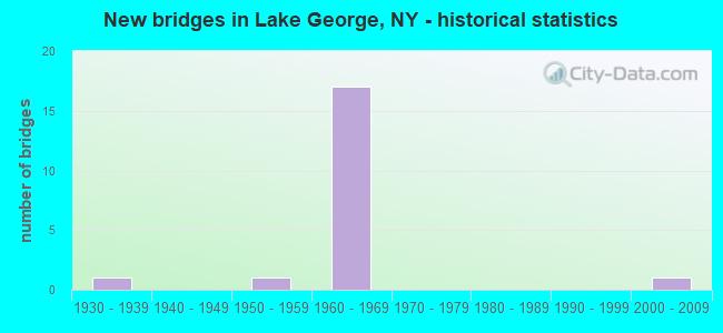
- New bridges - historical statistics
- 11930-1939
- 11950-1959
- 171960-1969
- 12000-2009


- Bridge Condition - Deck
- 11.1%Very good
- 55.6%Good
- 33.3%Satisfactory

- Bridge Condition - Superstructure
- 22.2%Very good
- 22.2%Good
- 33.3%Satisfactory
- 22.2%Fair

- Bridge Condition - Substructure
- 11.1%Good
- 33.3%Satisfactory
- 44.4%Fair
- 11.1%Poor

- Bridge Condition - Channel
- 40.0%Very good
- 20.0%Good
- 20.0%Fair
- 20.0%Poor
Find on map >> Show street view
Structure Number: 100572, Location: 0.2 MI NE JCT 9 & 9N (Lat: 43.433958, Lng: -73.715403), Route carried "on" structure: State highway 912Q, Year Built: 1964, Year Reconstructed: 2012, Status: Open, Structure Length: 4.33m (14.21ft), Average Daily Traffic: 4,922 (year 2020), Truck Traffic: 6%, Average Future Daily Traffic: 5,979 (year 2040), Design Load: HS 20, Features Intersected: Approach span, RTE 9
Minimum Vertical Clearance: 30+ m (98+ ft), Kilometerpoint: 0.354, Lanes on structure: 3, Lanes under structure: 3, Base Highway Network: Yes, Owner: State Highway Agency, Approaching Roadway Width: 14.0m (45.9ft), Skew: 20 degrees, Material/Design: Steel, Design/Construction: Stringer/Multi-beam, Number Of Spans In Main Unit: 3, Length of Maximum Span: 15.8m (51.8ft), Curb-To-Curb Width: 14.0m (45.9ft), Out-to-Out Width: 15.6m (51.2ft)
Condition: Deck: Very good, Superstructure: Very good, Substructure: Fair, Operating Rating: 77.1 metric tons, Method Used To Determine Operating Rating: Load Factor (LF), Inventory Rating: 46.3 metric tons, Method Used To Determine Inventory Rating: Load Factor (LF), Structural Evaluation: Somewhat better than minimum adequacy, Deck Geometry: Somewhat better than minimum adequacy, Underclear: High priority of corrective action, Approach Roadway Alignment: Equal to present desirable criteria, Length Of Structure Improvement: 4.32m (14.17ft), Designated Inspection Frequency: Every 24 months, Inspection Date: August 2020, Bridge Improvement Cost: $1,471,000, Roadway Improvement Cost: $862,000, Total Project Cost: $2,333,000 ( Estimate for 2021), Deck Structure Type: Concrete Cast-file-Place, Wearing Surface/Protective System: Wearing Surface: Integral Concrete, Deck Protection: Epoxy Coated Reinforcing
Find on map >> Show street view
Structure Number: 100573, Location: 0.4 MI NE JCT 9 & 9N (Lat: 43.436106, Lng: -73.718900), Route carried "on" structure: US 9, Year Built: 1957, Status: Open, Structure Length: 0.85m (2.79ft), Average Daily Traffic: 3,978 (year 2020), Truck Traffic: 6%, Average Future Daily Traffic: 4,832 (year 2040), Design Load: HS 20, Features Intersected: ENGLISH BROOK
Minimum Vertical Clearance: 30+ m (98+ ft), Kilometerpoint: 17.071, Lanes on structure: 2, Base Highway Network: Yes, Owner: State Highway Agency, Approaching Roadway Width: 11.0m (36.1ft), Skew: 22 degrees, Material/Design: Concrete, Design/Construction: Slab, Number Of Spans In Main Unit: 1, Length of Maximum Span: 7.6m (24.9ft), Curb or Sidewalk Widths: Left: 3.4m (11.2ft), Right: 1.4m (4.6ft), Curb-To-Curb Width: 12.5m (41.0ft), Out-to-Out Width: 18.1m (59.4ft)
Condition: Deck: Satisfactory, Superstructure: Satisfactory, Substructure: Satisfactory, Channel: Fair, Operating Rating: 52.6 metric tons, Method Used To Determine Operating Rating: Load Factor (LF), Inventory Rating: 30.8 metric tons, Method Used To Determine Inventory Rating: Load Factor (LF), Structural Evaluation: Equal to present minimum criteria, Deck Geometry: Equal to present minimum criteria, Waterway Adequacy: Superior to present desirable criteria, Approach Roadway Alignment: Equal to present desirable criteria, Length Of Structure Improvement: 0.85m (2.79ft), Designated Inspection Frequency: Every 24 months, Inspection Date: August 2021, Bridge Improvement Cost: $995,000, Roadway Improvement Cost: $582,000, Total Project Cost: $1,577,000 ( Estimate for 2021)
Find on map >> Show street view
Structure Number: 1005741, Location: JCT I87 & US 9 (Lat: 43.453125, Lng: -73.735381), Route carried "on" structure: Interstate 87, Year Built: 1965, Year Reconstructed: 2007, Status: Open, Structure Length: 10.09m (33.10ft), Average Daily Traffic: 11,066 (year 2014), Truck Traffic: 26%, Design Load: H 20, Features Intersected: RTE 9, ENGLISH BROOK
Minimum Vertical Clearance: 30+ m (98+ ft), Kilometerpoint: 22.542, Lanes on structure: 2, Lanes under structure: 2, Base Highway Network: Yes, Owner: State Highway Agency, Approaching Roadway Width: 9.1m (29.9ft), Skew: 4 degrees, Material/Design: Steel, Design/Construction: Stringer/Multi-beam, Number Of Spans In Main Unit: 3, Length of Maximum Span: 33.8m (110.9ft), Curb-To-Curb Width: 9.2m (30.2ft), Out-to-Out Width: 10.1m (33.1ft)
Condition: Deck: Good, Superstructure: Fair, Substructure: Fair, Channel: Very good, Operating Rating: 54.4 metric tons, Method Used To Determine Operating Rating: Load Factor (LF), Inventory Rating: 31.8 metric tons, Method Used To Determine Inventory Rating: Load Factor (LF), Structural Evaluation: Somewhat better than minimum adequacy, Deck Geometry: Meets minimum limits, Underclear: Somewhat better than minimum adequacy, Waterway Adequacy: Superior to present desirable criteria, Approach Roadway Alignment: Equal to present desirable criteria, Length Of Structure Improvement: 10.08m (33.07ft), Designated Inspection Frequency: Every 24 months, Inspection Date: June 2021, Bridge Improvement Cost: $2,367,000, Roadway Improvement Cost: $1,386,000, Total Project Cost: $3,753,000 ( Estimate for 2021), Deck Structure Type: Concrete Cast-file-Place, Wearing Surface/Protective System: Wearing Surface: Monolithic Concrete
Find on map >> Show street view
Structure Number: 1005742, Location: JCT I87 & US 9 (Lat: 43.452939, Lng: -73.734989), Route carried "on" structure: Interstate 87, Year Built: 1965, Status: Open, Structure Length: 10.09m (33.10ft), Average Daily Traffic: 9,868 (year 2020), Truck Traffic: 27%, Average Future Daily Traffic: 11,753 (year 2040), Design Load: H 20, Features Intersected: RTE 9, ENGLISH BROOK
Minimum Vertical Clearance: 30+ m (98+ ft), Kilometerpoint: 22.526, Lanes on structure: 3, Lanes under structure: 2, Base Highway Network: Yes, Owner: State Highway Agency, Approaching Roadway Width: 12.8m (42.0ft), Skew: 4 degrees, Material/Design: Steel, Design/Construction: Stringer/Multi-beam, Number Of Spans In Main Unit: 3, Length of Maximum Span: 33.8m (110.9ft), Curb-To-Curb Width: 12.9m (42.3ft), Out-to-Out Width: 13.8m (45.3ft)
Condition: Deck: Good, Superstructure: Fair, Substructure: Poor, Channel: Very good, Operating Rating: 79.8 metric tons, Method Used To Determine Operating Rating: Load Factor (LF), Inventory Rating: 47.2 metric tons, Method Used To Determine Inventory Rating: Load Factor (LF), Structural Evaluation: Meets minimum limits, Deck Geometry: Meets minimum limits, Underclear: Somewhat better than minimum adequacy, Waterway Adequacy: Superior to present desirable criteria, Approach Roadway Alignment: Equal to present desirable criteria, Length Of Structure Improvement: 10.08m (33.07ft), Designated Inspection Frequency: Every 24 months, Inspection Date: June 2021, Bridge Improvement Cost: $3,157,000, Roadway Improvement Cost: $1,849,000, Total Project Cost: $5,006,000 ( Estimate for 2021), Deck Structure Type: Concrete Cast-file-Place, Wearing Surface/Protective System: Wearing Surface: Bituminous
Find on map >> Show street view
Structure Number: 1006761, Location: JCT RTES 9N & I87 (Lat: 43.402211, Lng: -73.713186), Route carried "on" structure: Interstate 87, Year Built: 1963, Status: Open, Structure Length: 6.71m (22.01ft), Average Daily Traffic: 20,139 (year 2002), Truck Traffic: 9%, Design Load: H 20, Features Intersected: RTE 9N
Minimum Vertical Clearance: 30+ m (98+ ft), Kilometerpoint: 16.444, Lanes on structure: 4, Lanes under structure: 2, Base Highway Network: Yes, Owner: State Highway Agency, Approaching Roadway Width: 18.6m (61.0ft), Skew: 1 degrees, Material/Design: Steel, Design/Construction: Stringer/Multi-beam, Number Of Spans In Main Unit: 3, Length of Maximum Span: 23.7m (77.8ft), Curb or Sidewalk Widths: Left: 0.5m (1.6ft), Right: 0.5m (1.6ft), Curb-To-Curb Width: 16.5m (54.1ft), Out-to-Out Width: 18.0m (59.1ft)
Condition: Deck: Satisfactory, Superstructure: Good, Substructure: Satisfactory, Operating Rating: 55.3 metric tons, Method Used To Determine Operating Rating: Load Factor (LF), Inventory Rating: 32.7 metric tons, Method Used To Determine Inventory Rating: Load Factor (LF), Structural Evaluation: Equal to present minimum criteria, Deck Geometry: Meets minimum limits, Underclear: Meets minimum limits, Approach Roadway Alignment: Equal to present desirable criteria, Length Of Structure Improvement: 6.70m (21.98ft), Designated Inspection Frequency: Every 24 months, Inspection Date: July 2021, Bridge Improvement Cost: $2,595,000, Roadway Improvement Cost: $1,519,000, Total Project Cost: $4,114,000 ( Estimate for 2021), Deck Structure Type: Concrete Cast-file-Place, Wearing Surface/Protective System: Wearing Surface: Integral Concrete
Find on map >> Show street view
Structure Number: 1006762, Location: JCT RTES 9N & I87 (Lat: 43.403042, Lng: -73.712122), Route carried "on" structure: Interstate 87, Year Built: 1963, Status: Open, Structure Length: 5.06m (16.60ft), Average Daily Traffic: 9,949 (year 2018), Truck Traffic: 18%, Average Future Daily Traffic: 15,766 (year 2040), Design Load: H 20, Features Intersected: RTE 9N
Minimum Vertical Clearance: 30+ m (98+ ft), Kilometerpoint: 16.444, Lanes on structure: 3, Lanes under structure: 2, Base Highway Network: Yes, Owner: State Highway Agency, Approaching Roadway Width: 14.0m (45.9ft), Material/Design: Steel, Design/Construction: Stringer/Multi-beam, Number Of Spans In Main Unit: 3, Length of Maximum Span: 22.5m (73.8ft), Curb or Sidewalk Widths: Left: 0.5m (1.6ft), Right: 0.5m (1.6ft), Curb-To-Curb Width: 12.8m (42.0ft), Out-to-Out Width: 14.3m (46.9ft)
Condition: Deck: Good, Superstructure: Satisfactory, Substructure: Satisfactory, Operating Rating: 71.7 metric tons, Method Used To Determine Operating Rating: Load Factor (LF), Inventory Rating: 42.6 metric tons, Method Used To Determine Inventory Rating: Load Factor (LF), Structural Evaluation: Equal to present minimum criteria, Deck Geometry: High priority of replacement, Underclear: Somewhat better than minimum adequacy, Approach Roadway Alignment: Equal to present desirable criteria, Length Of Structure Improvement: 5.05m (16.57ft), Designated Inspection Frequency: Every 24 months, Inspection Date: July 2021, Bridge Improvement Cost: $1,569,000, Roadway Improvement Cost: $919,000, Total Project Cost: $2,487,000 ( Estimate for 2021), Deck Structure Type: Concrete Cast-file-Place, Wearing Surface/Protective System: Wearing Surface: Integral Concrete
Find on map >> Show street view
Structure Number: 103353, Location: 1.8 MI S JCT I87 & US9 (Lat: 43.429681, Lng: -73.720403), Route carried "on" structure: Ramp Interstate 912Q, Year Built: 1964, Status: Open, Structure Length: 11.55m (37.89ft), Average Daily Traffic: 2,010 (year 2018), Truck Traffic: 18%, Average Future Daily Traffic: 3,185 (year 2040), Design Load: H 20, Features Intersected: 87I 87I17101123NB, RTE I
Minimum Vertical Clearance: 30+ m (98+ ft), Kilometerpoint: 0.628, Lanes on structure: 2, Lanes under structure: 5, Owner: State Highway Agency, Approaching Roadway Width: 11.0m (36.1ft), Skew: 24 degrees, Material/Design: Steel, Design/Construction: Stringer/Multi-beam, Number Of Spans In Main Unit: 5, Length of Maximum Span: 24.0m (78.7ft), Curb-To-Curb Width: 9.8m (32.2ft), Out-to-Out Width: 11.4m (37.4ft)
Condition: Deck: Satisfactory, Superstructure: Satisfactory, Substructure: Fair, Operating Rating: 80.7 metric tons, Method Used To Determine Operating Rating: Load Factor (LF), Inventory Rating: 48.1 metric tons, Method Used To Determine Inventory Rating: Load Factor (LF), Structural Evaluation: Somewhat better than minimum adequacy, Deck Geometry: Equal to present minimum criteria, Underclear: High priority of corrective action, Approach Roadway Alignment: Equal to present desirable criteria, Length Of Structure Improvement: 11.55m (37.89ft), Designated Inspection Frequency: Every 24 months, Inspection Date: June 2021, Bridge Improvement Cost: $2,720,000, Roadway Improvement Cost: $1,593,000, Total Project Cost: $4,313,000 ( Estimate for 2021), Deck Structure Type: Concrete Cast-file-Place, Wearing Surface/Protective System: Wearing Surface: Integral Concrete
Find on map >> Show street view
Structure Number: 103354, Location: JCT EXIT 22 OF I87 & US 9 (Lat: 43.434756, Lng: -73.714622), Route carried "on" structure: Ramp Interstate 912Q, Year Built: 1964, Status: Open, Structure Length: 0.85m (2.79ft), Average Daily Traffic: 4,922 (year 2020), Truck Traffic: 6%, Average Future Daily Traffic: 5,979 (year 2040), Features Intersected: ENGLISH BROOK
Minimum Vertical Clearance: 30+ m (98+ ft), Kilometerpoint: 0.467, Lanes on structure: 2, Base Highway Network: Yes, Owner: State Highway Agency, Approaching Roadway Width: 14.6m (47.9ft), Skew: 22 degrees, Material/Design: Concrete, Design/Construction: Culvert, Number Of Spans In Main Unit: 2, Length of Maximum Span: 4.0m (13.1ft)
Condition: Channel: Poor, Culverts: Good, Structural Evaluation: Better than present minimum criteria, Waterway Adequacy: Superior to present desirable criteria, Approach Roadway Alignment: Equal to present desirable criteria, Length Of Structure Improvement: 0.85m (2.79ft), Designated Inspection Frequency: Every 24 months, Inspection Date: August 2021, Bridge Improvement Cost: $220,000, Roadway Improvement Cost: $129,000, Total Project Cost: $349,000 ( Estimate for 2021)
Find on map >> Show street view
Structure Number: 106039, Location: 0.7 MI N JCT I87 & 9N (Lat: 43.410839, Lng: -73.721644), Route carried "on" structure: ServiceOther road 917A, Year Built: 1964, Status: Open, Structure Length: 8.84m (29.00ft), Average Daily Traffic: 256 (year 2016), Truck Traffic: 2%, Average Future Daily Traffic: 358 (year 2036), Design Load: H 20, Features Intersected: 87I 87I17101110, RTE I87
Minimum Vertical Clearance: 30+ m (98+ ft), Kilometerpoint: 0.837, Lanes on structure: 2, Lanes under structure: 6, Base Highway Network: Yes, Toll: On toll road, Owner: State Highway Agency, Approaching Roadway Width: 11.9m (39.0ft), Skew: 2 degrees, Material/Design: Steel, Design/Construction: Stringer/Multi-beam, Number Of Spans In Main Unit: 5, Length of Maximum Span: 20.4m (66.9ft), Curb or Sidewalk Widths: Left: 0.5m (1.6ft), Right: 0.5m (1.6ft), Curb-To-Curb Width: 9.1m (29.9ft), Out-to-Out Width: 10.7m (35.1ft)
Condition: Deck: Good, Superstructure: Very good, Substructure: Fair, Operating Rating: 67.1 metric tons, Method Used To Determine Operating Rating: Load Factor (LF), Inventory Rating: 39.9 metric tons, Method Used To Determine Inventory Rating: Load Factor (LF), Structural Evaluation: Somewhat better than minimum adequacy, Deck Geometry: Equal to present minimum criteria, Underclear: High priority of corrective action, Approach Roadway Alignment: Equal to present desirable criteria, Length Of Structure Improvement: 8.83m (28.97ft), Designated Inspection Frequency: Every 24 months, Inspection Date: November 2020, Bridge Improvement Cost: $1,958,000, Roadway Improvement Cost: $1,147,000, Total Project Cost: $3,105,000 ( Estimate for 2021), Deck Structure Type: Concrete Cast-file-Place, Wearing Surface/Protective System: Wearing Surface: Bituminous
Find on map >> Show street view
Structure Number: 337017, Location: .6MI N I-87 EXIT22 +RTE.9 (Lat: 43.439942, Lng: -73.722703), Route carried "on" structure: Other road , Year Built: 2004, Status: Open, Structure Length: 0.94m (3.08ft), Average Daily Traffic: 76 (year 2018), Average Future Daily Traffic: 106 (year 2038), Design Load: HS 25 or greater, Features Intersected: ENGLISH BROOK, Facility Carried by Structure: BIG HOLLOW ROAD
Minimum Vertical Clearance: 30+ m (98+ ft), Kilometerpoint: 3.089, Lanes on structure: 1, Owner: Town or Township Highway Agency, Approaching Roadway Width: 3.7m (12.1ft), Material/Design: Concrete, Design/Construction: Frame, Number Of Spans In Main Unit: 1, Length of Maximum Span: 9.1m (29.9ft), Curb-To-Curb Width: 3.6m (11.8ft), Out-to-Out Width: 4.3m (14.1ft)
Condition: Deck: Good, Superstructure: Good, Substructure: Good, Channel: Good, Inventory Rating: 61.7 metric tons, Method Used To Determine Inventory Rating: Load Factor (LF), Structural Evaluation: Better than present minimum criteria, Deck Geometry: High priority of corrective action, Waterway Adequacy: Superior to present desirable criteria, Approach Roadway Alignment: Somewhat better than minimum adequacy, Length Of Structure Improvement: 0.94m (3.08ft), Designated Inspection Frequency: Every 24 months, Inspection Date: April 2020, Bridge Improvement Cost: $117,000, Roadway Improvement Cost: $69,000, Total Project Cost: $186,000 ( Estimate for 2021), Wearing Surface/Protective System: Wearing Surface: Bituminous
Find on map >> Show street view
Structure Number: 100572, Location: 0.2 MI NE JCT 9 & 9N (Lat: 43.433958, Lng: -73.715403), Route carried "under" structure: US 9, Year Built: 1964, Structure Length: 0. m, Average Daily Traffic: 4,596 (year 2000), Features Intersected: Approach span, RTE 9
Minimum Vertical Clearance: 4.75m (15.58ft), Kilometerpoint: 14.159, Lanes on structure: 3, Lanes under structure: 3, Material/Design: Steel, Design/Construction: Stringer/Multi-beam, Length of Maximum Span: 15.8m (51.8ft)
Find on map >> Show street view
Structure Number: 1005741, Location: JCT I87 & US 9 (Lat: 43.453125, Lng: -73.735381), Route carried "under" structure: US 9, Year Built: 1965, Structure Length: 0. m, Average Daily Traffic: 4,596 (year 2000), Features Intersected: RTE 9, ENGLISH BROOK, Facility Carried by Structure: RTE I87
Minimum Vertical Clearance: 16.99m (55.74ft), Kilometerpoint: 16.830, Lanes on structure: 2, Lanes under structure: 2, Material/Design: Steel, Design/Construction: Stringer/Multi-beam, Length of Maximum Span: 33.8m (110.9ft)
Find on map >> Show street view
Structure Number: 1005742, Location: JCT I87 & US 9 (Lat: 43.452939, Lng: -73.734989), Route carried "under" structure: US 9, Year Built: 1965, Structure Length: 0. m, Average Daily Traffic: 4,596 (year 2000), Features Intersected: RTE 9, ENGLISH BROOK, Facility Carried by Structure: RTE I87
Minimum Vertical Clearance: 16.99m (55.74ft), Kilometerpoint: 16.814, Lanes on structure: 3, Lanes under structure: 2, Material/Design: Steel, Design/Construction: Stringer/Multi-beam, Length of Maximum Span: 33.8m (110.9ft)
Find on map >> Show street view
Structure Number: 1006761, Location: JCT RTES 9N & I87 (Lat: 43.402211, Lng: -73.713186), Route carried "under" structure: US 9N, Year Built: 1963, Structure Length: 0. m, Average Daily Traffic: 10,962 (year 2000), Features Intersected: RTE 9N, Facility Carried by Structure: RTE I87
Minimum Vertical Clearance: 7.99m (26.21ft), Kilometerpoint: 18.053, Lanes on structure: 4, Lanes under structure: 2, Material/Design: Steel, Design/Construction: Stringer/Multi-beam, Length of Maximum Span: 23.7m (77.8ft)
Find on map >> Show street view
Structure Number: 1006762, Location: JCT RTES 9N & I87 (Lat: 43.403042, Lng: -73.712122), Route carried "under" structure: US 9N, Year Built: 1963, Structure Length: 0. m, Average Daily Traffic: 10,962 (year 2000), Features Intersected: RTE 9N, Facility Carried by Structure: RTE I87
Minimum Vertical Clearance: 4.62m (15.16ft), Kilometerpoint: 18.182, Lanes on structure: 3, Lanes under structure: 2, Material/Design: Steel, Design/Construction: Stringer/Multi-beam, Length of Maximum Span: 22.5m (73.8ft)
Find on map >> Show street view
Structure Number: 103352, Location: 2.1 MI S JCT I87 & 9 (Lat: 43.425500, Lng: -73.721003), Route carried "under" structure: Interstate 87, Year Built: 1964, Structure Length: 0. m, Average Daily Traffic: 9,314 (year 1998), Features Intersected: 87I 87I17101120 NB, RTE, Facility Carried by Structure: PROSPECT MT TRAIL
Minimum Vertical Clearance: 8.99m (29.49ft), Kilometerpoint: 19.662, Lanes under structure: 3, Material/Design: Steel, Design/Construction: Girder and Floorbeam System, Length of Maximum Span: 22.8m (74.8ft)
Find on map >> Show street view
Structure Number: 103352, Location: 2.1 MI S JCT I87 & 9 (Lat: 43.425500, Lng: -73.721003), Route carried "under" structure: Interstate , Year Built: 1964, Structure Length: 0. m, Average Daily Traffic: 2,000 (year 2021), Features Intersected: 87I 87I17101120 NB, RTE, Facility Carried by Structure: PROSPECT MT TRAIL
Minimum Vertical Clearance: 4.65m (15.26ft), Kilometerpoint: 19.662, Lanes under structure: 1, Material/Design: Steel, Design/Construction: Girder and Floorbeam System, Length of Maximum Span: 22.8m (74.8ft)
Find on map >> Show street view
Structure Number: 103353, Location: 1.8 MI S JCT I87 & US9 (Lat: 43.429681, Lng: -73.720403), Route carried "under" structure: Interstate 87, Year Built: 1964, Structure Length: 0. m, Average Daily Traffic: 9,314 (year 1998), Features Intersected: 87I 87I17101123NB, RTE I, Facility Carried by Structure: RTE 912Q
Minimum Vertical Clearance: 5.89m (19.32ft), Kilometerpoint: 20.129, Lanes on structure: 2, Lanes under structure: 2, Material/Design: Steel, Design/Construction: Stringer/Multi-beam, Length of Maximum Span: 24.0m (78.7ft)
Find on map >> Show street view
Structure Number: 106039, Location: 0.7 MI N JCT I87 & 9N (Lat: 43.410839, Lng: -73.721644), Route carried "under" structure: Interstate 87, Year Built: 1964, Structure Length: 0. m, Average Daily Traffic: 9,314 (year 1998), Features Intersected: 87I 87I17101110, RTE I87, Facility Carried by Structure: RTE 917A
Minimum Vertical Clearance: 5.11m (16.77ft), Kilometerpoint: 18.037, Lanes on structure: 2, Lanes under structure: 3, Material/Design: Steel, Design/Construction: Stringer/Multi-beam, Length of Maximum Span: 20.4m (66.9ft)
Find on map >> Show street view
Structure Number: 300665, Location: 0.3 MI NE JCT 9 + 9L (Lat: 43.411075, Lng: -73.706703), Route carried "under" structure: State highway 9L, Year Built: 1938, Structure Length: 0. m, Average Daily Traffic: 3,866 (year 1998), Features Intersected: RTE 9L, Facility Carried by Structure: COUNTY BIKE PATH
Minimum Vertical Clearance: 4.34m (14.24ft), Kilometerpoint: 29.445, Lanes under structure: 2, Material/Design: Steel, Design/Construction: Girder and Floorbeam System, Length of Maximum Span: 21.3m (69.9ft)