Bridge Statistics for Lake Murray of Richland, South Carolina (SC)
Condition, Traffic, Stress, Structural Evaluation, Project Costs
- National Bridge Inventory (NBI) Statistics
- 13Number of bridges
- 384ft / 117mTotal length
- $4,908,000Total costs
- 179,650Total average daily traffic
- 22,994Total average daily truck traffic
- National Bridge Inventory (NBI) Registered Bridges for Lake Murray of Richland
- No street view available for this location
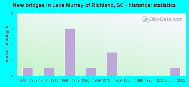
- New bridges - historical statistics
- 11930-1939
- 11940-1949
- 61950-1959
- 11960-1969
- 31970-1979
- 12000-2009


- Bridge Condition - Deck
- 40.0%Good
- 20.0%Satisfactory
- 40.0%Fair

- Bridge Condition - Superstructure
- 50.0%Good
- 10.0%Satisfactory
- 20.0%Fair
- 20.0%Poor

- Bridge Condition - Substructure
- 20.0%Good
- 30.0%Satisfactory
- 40.0%Fair
- 10.0%Poor

- Bridge Condition - Channel
- 62.5%Very good
- 12.5%Satisfactory
- 25.0%Fair
Find on map >> Show street view
Structure Number: 969, Location: 4 MI NW OF IRMO (Lat: 34.125531, Lng: -81.231344), Route carried "on" structure: US 76, Year Built: 1939, Status: Posted for load, Structure Length: 12.07m (39.60ft), Average Daily Traffic: 21,200 (year 2021), Truck Traffic: 3%, Average Future Daily Traffic: 28,620 (year 2041), Design Load: H 15, Features Intersected: RR CSXT
Minimum Vertical Clearance: 30+ m (98+ ft), Kilometerpoint: 8.164, Lanes on structure: 2, Owner: State Highway Agency, Approaching Roadway Width: 11.9m (39.0ft), Material/Design: Steel, Design/Construction: Stringer/Multi-beam, Number Of Spans In Main Unit: 9, Length of Maximum Span: 13.4m (44.0ft), Curb or Sidewalk Widths: Left: 1.4m (4.6ft), Right: 1.4m (4.6ft), Curb-To-Curb Width: 9.1m (29.9ft), Out-to-Out Width: 12.9m (42.3ft)
Condition: Deck: Good, Superstructure: Fair, Substructure: Fair, Operating Rating: 21.1 metric tons, Method Used To Determine Operating Rating: Load and Resistance Factor Rating (LRFR) rating reported by rating factor(RF) method using HL-93 loadings, Inventory Rating: 16.2 metric tons, Method Used To Determine Inventory Rating: Load and Resistance Factor Rating (LRFR) rating reported by rating factor(RF) method using HL-93 loadings, Structural Evaluation: Meets minimum limits, Deck Geometry: Meets minimum limits, Underclear: Meets minimum limits, Approach Roadway Alignment: Equal to present desirable criteria, Bridge Posting: Required (Relationship of Operating Rating to Maximum Legal Load: 20.0 - 29.9% below), Length Of Structure Improvement: 12.07m (39.60ft), Designated Inspection Frequency: Every 24 months, Critical Feature Inspection Frequency: Every 24 months, Other Special Inspection Frequency: Every 24 months, Inspection Date: December 2021, Critical Feature Inspection Date: December 2021, Other Special Inspection Date: December 2021, Deck Structure Type: Concrete Cast-file-Place, Wearing Surface/Protective System: Wearing Surface: Bituminous
Find on map >> Show street view
Structure Number: 1646, Location: 6 MI E OF CHAPIN (Lat: 34.158656, Lng: -81.253628), Route carried "on" structure: US 176, Year Built: 1949, Status: Open, Structure Length: 0.64m (2.10ft), Average Daily Traffic: 10,700 (year 2021), Truck Traffic: 4%, Average Future Daily Traffic: 14,445 (year 2041), Design Load: H 15, Features Intersected: BOYD BRANCH
Minimum Vertical Clearance: 30+ m (98+ ft), Kilometerpoint: 11.113, Lanes on structure: 2, Owner: State Highway Agency, Approaching Roadway Width: 15.2m (49.9ft), Material/Design: Concrete, Design/Construction: Culvert, Number Of Spans In Main Unit: 2, Length of Maximum Span: 3.0m (9.8ft), Curb-To-Curb Width: 15.2m (49.9ft), Out-to-Out Width: 15.8m (51.8ft)
Condition: Channel: Very good, Culverts: Satisfactory, Operating Rating: 22.4 metric tons, Method Used To Determine Operating Rating: Load and Resistance Factor Rating (LRFR) rating reported by rating factor(RF) method using HL-93 loadings, Inventory Rating: 17.2 metric tons, Method Used To Determine Inventory Rating: Load and Resistance Factor Rating (LRFR) rating reported by rating factor(RF) method using HL-93 loadings, Structural Evaluation: Meets minimum limits, Deck Geometry: Superior to present desirable criteria, Waterway Adequacy: Better than present minimum criteria, Approach Roadway Alignment: Equal to present desirable criteria, Length Of Structure Improvement: 0.64m (2.10ft), Designated Inspection Frequency: Every 24 months, Inspection Date: December 2021
Find on map >> Show street view
Structure Number: 2245, Location: 2 MI NW OF WHITE ROCK (Lat: 34.156136, Lng: -81.299097), Route carried "on" structure: State highway 405, Year Built: 1955, Year Reconstructed: 1993, Status: Open, Structure Length: 1.71m (5.61ft), Average Daily Traffic: 1,900 (year 2020), Truck Traffic: 4%, Average Future Daily Traffic: 3,686 (year 2040), Design Load: H 10, Features Intersected: WATEREE CREEK
Minimum Vertical Clearance: 30+ m (98+ ft), Kilometerpoint: 2.501, Lanes on structure: 2, Owner: State Highway Agency, Approaching Roadway Width: 7.3m (24.0ft), Material/Design: Concrete, Design/Construction: Slab, Number Of Spans In Main Unit: 4, Length of Maximum Span: 4.3m (14.1ft), Curb-To-Curb Width: 7.3m (24.0ft), Out-to-Out Width: 7.7m (25.3ft)
Condition: Deck: Satisfactory, Superstructure: Satisfactory, Substructure: Satisfactory, Channel: Very good, Operating Rating: 20.1 metric tons, Method Used To Determine Operating Rating: Load and Resistance Factor Rating (LRFR) rating reported by rating factor(RF) method using HL-93 loadings, Inventory Rating: 15.2 metric tons, Method Used To Determine Inventory Rating: Load and Resistance Factor Rating (LRFR) rating reported by rating factor(RF) method using HL-93 loadings, Structural Evaluation: Meets minimum limits, Deck Geometry: Meets minimum limits, Waterway Adequacy: Better than present minimum criteria, Approach Roadway Alignment: Equal to present desirable criteria, Bridge Posting: Required (Relationship of Operating Rating to Maximum Legal Load: 30.0 - 39.9% below), Length Of Structure Improvement: 1.71m (5.61ft), Designated Inspection Frequency: Every 24 months, Inspection Date: December 2020, Deck Structure Type: Concrete Precast Panels, Wearing Surface/Protective System: Wearing Surface: Bituminous
Find on map >> Show street view
Structure Number: 2298, Location: 10MI SW OF BEAUFORT (Lat: 32.374275, Lng: -80.834586), Route carried "on" structure: State highway 170, Year Built: 2004, Status: Open, Structure Length: 56.51m (185.40ft), Average Daily Traffic: 24,900 (year 2020), Truck Traffic: 5%, Average Future Daily Traffic: 61,503 (year 2040), Design Load: HS 25 or greater, Features Intersected: CHECHESSEE RIVER
Minimum Vertical Clearance: 3.63m (11.91ft), Kilometerpoint: 25.989, Lanes on structure: 4, Base Highway Network: Yes, Owner: State Highway Agency, Approaching Roadway Width: 19.5m (64.0ft), Skew: 20 degrees, Navigation Control: Yes ( Vertical Clearance: 6.1m (20.0ft), Horizontal Clearance: 20.1m (65.9ft)), Material/Design: Prestressed concrete continuous, Design/Construction: Stringer/Multi-beam, Number Of Spans In Main Unit: 13, Length of Maximum Span: 44.8m (147.0ft), Curb-To-Curb Width: 23.8m (78.1ft), Out-to-Out Width: 24.7m (81.0ft)
Condition: Deck: Fair, Superstructure: Good, Substructure: Good, Channel: Very good, Operating Rating: 45.7 metric tons, Method Used To Determine Operating Rating: Load and Resistance Factor Rating (LRFR) rating reported by rating factor(RF) method using HL-93 loadings, Inventory Rating: 26.9 metric tons, Method Used To Determine Inventory Rating: Load and Resistance Factor Rating (LRFR) rating reported by rating factor(RF) method using HL-93 loadings, Structural Evaluation: Equal to present minimum criteria, Deck Geometry: Superior to present desirable criteria, Waterway Adequacy: Equal to present minimum criteria, Approach Roadway Alignment: Equal to present desirable criteria, Length Of Structure Improvement: 56.51m (185.40ft), Designated Inspection Frequency: Every 24 months, Underwater Inspection Frequency: Every 60 months, Inspection Date: March 2020, Underwater Inspection Date: January 2021, Deck Structure Type: Concrete Cast-file-Place, Wearing Surface/Protective System: Wearing Surface: Monolithic Concrete
Find on map >> Show street view
Structure Number: 2523, Location: 13.5MI NW WINNSBORO (Lat: 34.551411, Lng: -81.192439), Route carried "on" structure: State highway 214, Year Built: 1957, Status: Posted for load, Structure Length: 2.74m (8.99ft), Average Daily Traffic: 125 (year 2020), Truck Traffic: 5%, Average Future Daily Traffic: 160 (year 2040), Design Load: H 15, Features Intersected: BIG CREEK
Minimum Vertical Clearance: 30+ m (98+ ft), Kilometerpoint: 2.713, Lanes on structure: 2, Owner: State Highway Agency, Approaching Roadway Width: 9.1m (29.9ft), Material/Design: Prestressed concrete, Design/Construction: Stringer/Multi-beam, Number Of Spans In Main Unit: 3, Length of Maximum Span: 9.1m (29.9ft), Curb-To-Curb Width: 7.3m (24.0ft), Out-to-Out Width: 7.8m (25.6ft)
Condition: Deck: Fair, Superstructure: Fair, Substructure: Fair, Channel: Fair, Operating Rating: 13.6 metric tons, Method Used To Determine Operating Rating: Load and Resistance Factor Rating (LRFR) rating reported by rating factor(RF) method using HL-93 loadings, Inventory Rating: 7.5 metric tons, Method Used To Determine Inventory Rating: Load and Resistance Factor Rating (LRFR) rating reported by rating factor(RF) method using HL-93 loadings, Structural Evaluation: High priority of replacement, Deck Geometry: Somewhat better than minimum adequacy, Waterway Adequacy: Equal to present desirable criteria, Approach Roadway Alignment: Equal to present desirable criteria, Bridge Posting: Required (Relationship of Operating Rating to Maximum Legal Load: > 39.9% below), Length Of Structure Improvement: 3.57m (11.71ft), Designated Inspection Frequency: Every 12 months, Inspection Date: December 2021, Bridge Improvement Cost: $284,000, Roadway Improvement Cost: $71,000, Total Project Cost: $426,000 ( Estimate for 2021), Deck Structure Type: Concrete Precast Panels, Wearing Surface/Protective System: Wearing Surface: Bituminous
Find on map >> Show street view
Structure Number: 2829, Location: 1 MI N OF WHITE ROCK (Lat: 34.159642, Lng: -81.273097), Route carried "on" structure: State highway 234, Year Built: 1958, Status: Open, Structure Length: 6.55m (21.49ft), Average Daily Traffic: 5,200 (year 2020), Truck Traffic: 3%, Average Future Daily Traffic: 10,088 (year 2040), Design Load: HS 15, Features Intersected: I-26
Minimum Vertical Clearance: 30+ m (98+ ft), Kilometerpoint: 1.725, Lanes on structure: 2, Lanes under structure: 4, Owner: State Highway Agency, Approaching Roadway Width: 11.9m (39.0ft), Material/Design: Concrete, Design/Construction: Tee Beam, Number Of Spans In Main Unit: 4, Length of Maximum Span: 17.1m (56.1ft), Curb or Sidewalk Widths: Left: 0.5m (1.6ft), Right: 0.5m (1.6ft), Curb-To-Curb Width: 7.9m (25.9ft), Out-to-Out Width: 9.1m (29.9ft)
Condition: Deck: Fair, Superstructure: Poor, Substructure: Satisfactory, Operating Rating: 25.9 metric tons, Method Used To Determine Operating Rating: Load and Resistance Factor Rating (LRFR) rating reported by rating factor(RF) method using HL-93 loadings, Inventory Rating: 18.5 metric tons, Method Used To Determine Inventory Rating: Load and Resistance Factor Rating (LRFR) rating reported by rating factor(RF) method using HL-93 loadings, Structural Evaluation: Meets minimum limits, Deck Geometry: High priority of corrective action, Underclear: Meets minimum limits, Approach Roadway Alignment: Equal to present desirable criteria, Length Of Structure Improvement: 7.55m (24.77ft), Designated Inspection Frequency: Every 12 months, Inspection Date: January 2021, Bridge Improvement Cost: $955,000, Roadway Improvement Cost: $239,000, Total Project Cost: $1,433,000 ( Estimate for 2021), Deck Structure Type: Concrete Cast-file-Place, Wearing Surface/Protective System: Wearing Surface: Bituminous
Find on map >> Show street view
Structure Number: 3085, Location: 2 MI NW OF WHITE ROCK (Lat: 34.166561, Lng: -81.291672), Route carried "on" structure: State highway 405, Year Built: 1959, Status: Open, Structure Length: 6.64m (21.78ft), Average Daily Traffic: 1,900 (year 2020), Truck Traffic: 4%, Average Future Daily Traffic: 3,686 (year 2040), Design Load: HS 15, Features Intersected: I-26
Minimum Vertical Clearance: 5.21m (17.09ft), Kilometerpoint: 1.004, Lanes on structure: 2, Lanes under structure: 4, Owner: State Highway Agency, Approaching Roadway Width: 7.9m (25.9ft), Skew: 1 degrees, Material/Design: Concrete, Design/Construction: Tee Beam, Number Of Spans In Main Unit: 4, Length of Maximum Span: 17.1m (56.1ft), Curb or Sidewalk Widths: Left: 0.5m (1.6ft), Right: 0.5m (1.6ft), Curb-To-Curb Width: 7.9m (25.9ft), Out-to-Out Width: 9.2m (30.2ft)
Condition: Deck: Satisfactory, Superstructure: Poor, Substructure: Satisfactory, Operating Rating: 23.0 metric tons, Method Used To Determine Operating Rating: Load and Resistance Factor Rating (LRFR) rating reported by rating factor(RF) method using HL-93 loadings, Inventory Rating: 16.2 metric tons, Method Used To Determine Inventory Rating: Load and Resistance Factor Rating (LRFR) rating reported by rating factor(RF) method using HL-93 loadings, Structural Evaluation: Meets minimum limits, Deck Geometry: Meets minimum limits, Underclear: High priority of replacement, Approach Roadway Alignment: Equal to present desirable criteria, Bridge Posting: Required (Relationship of Operating Rating to Maximum Legal Load: 20.0 - 29.9% below), Length Of Structure Improvement: 7.64m (25.07ft), Designated Inspection Frequency: Every 12 months, Other Special Inspection Frequency: Every 24 months, Inspection Date: January 2021, Other Special Inspection Date: July 2021, Bridge Improvement Cost: $771,000, Roadway Improvement Cost: $193,000, Total Project Cost: $1,157,000 ( Estimate for 2021), Deck Structure Type: Concrete Cast-file-Place, Wearing Surface/Protective System: Wearing Surface: Monolithic Concrete
Find on map >> Show street view
Structure Number: 3963, Location: 2.0 MI SE CENTRAL (Lat: 34.704897, Lng: -82.756983), Route carried "on" structure: State highway 18, Year Built: 1962, Status: Open, Structure Length: 4.57m (14.99ft), Average Daily Traffic: 8,400 (year 2020), Truck Traffic: 6%, Average Future Daily Traffic: 17,304 (year 2040), Design Load: HS 15, Features Intersected: EIGHTEEN MILE CREEK
Minimum Vertical Clearance: 30+ m (98+ ft), Kilometerpoint: 1.735, Lanes on structure: 2, Owner: State Highway Agency, Approaching Roadway Width: 7.3m (24.0ft), Skew: 2 degrees, Material/Design: Concrete, Design/Construction: Tee Beam, Number Of Spans In Main Unit: 5, Length of Maximum Span: 9.1m (29.9ft), Curb-To-Curb Width: 8.6m (28.2ft), Out-to-Out Width: 9.6m (31.5ft)
Condition: Deck: Fair, Superstructure: Good, Substructure: Poor, Channel: Fair, Operating Rating: 30.5 metric tons, Method Used To Determine Operating Rating: Load and Resistance Factor Rating (LRFR) rating reported by rating factor(RF) method using HL-93 loadings, Inventory Rating: 23.7 metric tons, Method Used To Determine Inventory Rating: Load and Resistance Factor Rating (LRFR) rating reported by rating factor(RF) method using HL-93 loadings, Structural Evaluation: Meets minimum limits, Deck Geometry: High priority of replacement, Waterway Adequacy: Equal to present desirable criteria, Approach Roadway Alignment: Equal to present desirable criteria, Length Of Structure Improvement: 5.49m (18.01ft), Designated Inspection Frequency: Every 12 months, Inspection Date: December 2021, Bridge Improvement Cost: $694,000, Roadway Improvement Cost: $174,000, Total Project Cost: $1,041,000 ( Estimate for 2021), Deck Structure Type: Concrete Cast-file-Place, Wearing Surface/Protective System: Wearing Surface: Monolithic Concrete
Find on map >> Show street view
Structure Number: 6147, Location: 4 MI SE OF BISHOPVILLE (Lat: 34.187794, Lng: -80.193319), Route carried "on" structure: Interstate 20, Year Built: 1972, Status: Open, Structure Length: 18.29m (60.01ft), Average Daily Traffic: 12,300 (year 2020), Truck Traffic: 19%, Average Future Daily Traffic: 19,680 (year 2040), Design Load: HS 20+Mod, Features Intersected: LYNCHES RIVER
Minimum Vertical Clearance: 30+ m (98+ ft), Kilometerpoint: 194.552, Lanes on structure: 2, Base Highway Network: Yes, Owner: State Highway Agency, Approaching Roadway Width: 12.2m (40.0ft), Material/Design: Concrete, Design/Construction: Slab, Number Of Spans In Main Unit: 20, Length of Maximum Span: 9.1m (29.9ft), Curb-To-Curb Width: 12.2m (40.0ft), Out-to-Out Width: 13.3m (43.6ft)
Condition: Deck: Good, Superstructure: Good, Substructure: Good, Channel: Satisfactory, Operating Rating: 55.1 metric tons, Method Used To Determine Operating Rating: Load and Resistance Factor Rating (LRFR) rating reported by rating factor(RF) method using HL-93 loadings, Inventory Rating: 42.4 metric tons, Method Used To Determine Inventory Rating: Load and Resistance Factor Rating (LRFR) rating reported by rating factor(RF) method using HL-93 loadings, Structural Evaluation: Better than present minimum criteria, Deck Geometry: Better than present minimum criteria, Waterway Adequacy: Better than present minimum criteria, Approach Roadway Alignment: Equal to present desirable criteria, Length Of Structure Improvement: 18.29m (60.01ft), Designated Inspection Frequency: Every 24 months, Underwater Inspection Frequency: Every 60 months, Inspection Date: August 2020, Underwater Inspection Date: September 2021, Deck Structure Type: Concrete Cast-file-Place, Wearing Surface/Protective System: Wearing Surface: Monolithic Concrete
Find on map >> Show street view
Structure Number: 7163, Location: 6 MI NE OF CHAPIN (Lat: 34.196408, Lng: -81.259264), Route carried "on" structure: State highway 698, Year Built: 1978, Status: Open, Structure Length: 5.49m (18.01ft), Average Daily Traffic: 275 (year 2020), Truck Traffic: 5%, Average Future Daily Traffic: 352 (year 2040), Design Load: H 15, Features Intersected: WATEREE CREEK
Minimum Vertical Clearance: 30+ m (98+ ft), Kilometerpoint: 2.353, Lanes on structure: 2, Owner: State Highway Agency, Approaching Roadway Width: 10.4m (34.1ft), Material/Design: Prestressed concrete, Design/Construction: Channel Beam, Number Of Spans In Main Unit: 6, Length of Maximum Span: 9.1m (29.9ft), Curb-To-Curb Width: 9.9m (32.5ft), Out-to-Out Width: 10.3m (33.8ft)
Condition: Deck: Good, Superstructure: Good, Substructure: Fair, Channel: Very good, Operating Rating: 13.3 metric tons, Method Used To Determine Operating Rating: Allowable Stress (AS) rating reported by rating factor (RF) method using MS18 loading, Inventory Rating: 6.2 metric tons, Method Used To Determine Inventory Rating: Allowable Stress (AS) rating reported by rating factor (RF) method using MS18 loading, Structural Evaluation: High priority of replacement, Deck Geometry: Better than present minimum criteria, Waterway Adequacy: Better than present minimum criteria, Approach Roadway Alignment: Equal to present desirable criteria, Bridge Posting: Required (Relationship of Operating Rating to Maximum Legal Load: > 39.9% below), Length Of Structure Improvement: 6.44m (21.13ft), Designated Inspection Frequency: Every 24 months, Inspection Date: December 2020, Bridge Improvement Cost: $567,000, Roadway Improvement Cost: $142,000, Total Project Cost: $851,000 ( Estimate for 2021), Deck Structure Type: Concrete Cast-file-Place, Wearing Surface/Protective System: Wearing Surface: Bituminous
Find on map >> Show street view
Structure Number: 7293, Location: 4 MI NW OF BALLENTINE (Lat: 34.184311, Lng: -81.270447), Route carried "on" structure: State highway 2480, Year Built: 1979, Status: Open, Structure Length: 1.37m (4.49ft), Average Daily Traffic: 750 (year 2020), Truck Traffic: 5%, Average Future Daily Traffic: 960 (year 2040), Design Load: H 10, Features Intersected: BR OF WATEREE CREEK
Minimum Vertical Clearance: 30+ m (98+ ft), Kilometerpoint: 1.979, Lanes on structure: 2, Owner: State Highway Agency, Approaching Roadway Width: 9.8m (32.2ft), Material/Design: Concrete, Design/Construction: Slab, Number Of Spans In Main Unit: 3, Length of Maximum Span: 4.6m (15.1ft), Curb-To-Curb Width: 9.6m (31.5ft), Out-to-Out Width: 10.1m (33.1ft)
Condition: Deck: Good, Superstructure: Good, Substructure: Fair, Channel: Very good, Operating Rating: 21.4 metric tons, Method Used To Determine Operating Rating: Load and Resistance Factor Rating (LRFR) rating reported by rating factor(RF) method using HL-93 loadings, Inventory Rating: 16.5 metric tons, Method Used To Determine Inventory Rating: Load and Resistance Factor Rating (LRFR) rating reported by rating factor(RF) method using HL-93 loadings, Structural Evaluation: Meets minimum limits, Deck Geometry: Equal to present minimum criteria, Waterway Adequacy: Better than present minimum criteria, Approach Roadway Alignment: Equal to present minimum criteria, Bridge Posting: Required (Relationship of Operating Rating to Maximum Legal Load: 20.0 - 29.9% below), Length Of Structure Improvement: 1.37m (4.49ft), Designated Inspection Frequency: Every 24 months, Inspection Date: December 2020, Deck Structure Type: Concrete Cast-file-Place, Wearing Surface/Protective System: Wearing Surface: Bituminous
Find on map >> Show street view
Structure Number: 2829, Location: 1 MI N OF WHITE ROCK (Lat: 34.159642, Lng: -81.273097), Route carried "under" structure: Interstate 26, Year Built: 1958, Structure Length: 0. m, Average Daily Traffic: 46,000 (year 2020), Truck Traffic: 19%, Features Intersected: I-26, Facility Carried by Structure: S-40-234
Minimum Vertical Clearance: 4.95m (16.24ft), Kilometerpoint: 151.793, Lanes on structure: 2, Lanes under structure: 4, Material/Design: Concrete, Design/Construction: Tee Beam, Length of Maximum Span: 17.1m (56.1ft)
Find on map >> Show street view
Structure Number: 3085, Location: 2 MI NW OF WHITE ROCK (Lat: 34.166561, Lng: -81.291672), Route carried "under" structure: Interstate 26, Year Built: 1959, Structure Length: 0. m, Average Daily Traffic: 46,000 (year 2020), Truck Traffic: 19%, Features Intersected: I-26, Facility Carried by Structure: S-40-405
Minimum Vertical Clearance: 5.21m (17.09ft), Kilometerpoint: 149.926, Lanes on structure: 2, Lanes under structure: 4, Material/Design: Concrete, Design/Construction: Tee Beam, Length of Maximum Span: 17.1m (56.1ft)