Bridge Statistics for Lake Ozark, Missouri (MO)
Condition, Traffic, Stress, Structural Evaluation, Project Costs
- National Bridge Inventory (NBI) Statistics
- 22Number of bridges
- 732ft / 223mTotal length
- $13,061,000Total costs
- 103,268Total average daily traffic
- 10,415Total average daily truck traffic
- National Bridge Inventory (NBI) Registered Bridges for Lake Ozark
- No street view available for this location
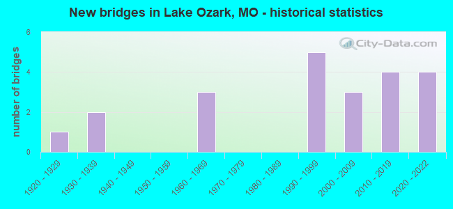
- New bridges - historical statistics
- 11920-1929
- 21930-1939
- 31960-1969
- 51990-1999
- 32000-2009
- 42010-2019
- 42020-2022
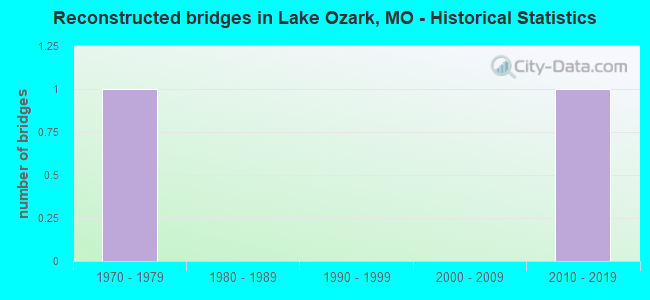
- Reconstructed bridges - Historical Statistics
- 11970-1979
- 01980-1989
- 01990-1999
- 02000-2009
- 12010-2019
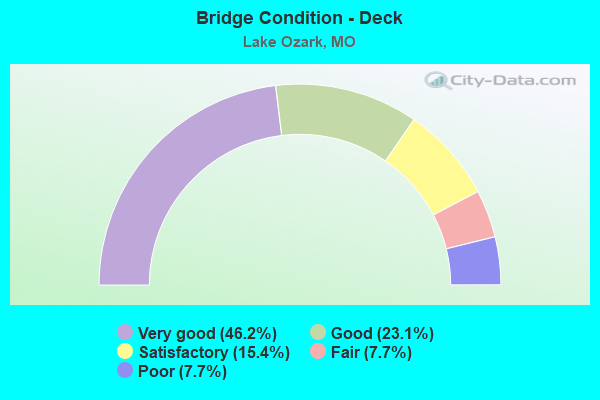
- Bridge Condition - Deck
- 46.2%Very good
- 23.1%Good
- 15.4%Satisfactory
- 7.7%Fair
- 7.7%Poor
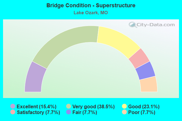
- Bridge Condition - Superstructure
- 15.4%Excellent
- 38.5%Very good
- 23.1%Good
- 7.7%Satisfactory
- 7.7%Fair
- 7.7%Poor
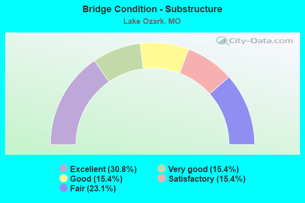
- Bridge Condition - Substructure
- 30.8%Excellent
- 15.4%Very good
- 15.4%Good
- 15.4%Satisfactory
- 23.1%Fair
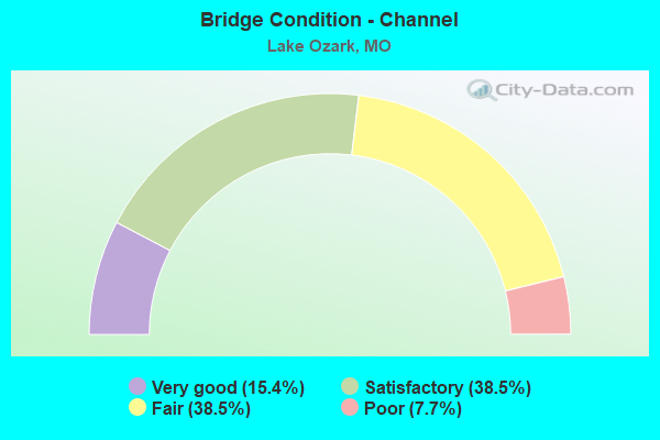
- Bridge Condition - Channel
- 15.4%Very good
- 38.5%Satisfactory
- 38.5%Fair
- 7.7%Poor
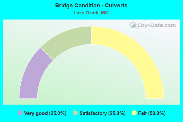
- Bridge Condition - Culverts
- 25.0%Very good
- 25.0%Satisfactory
- 50.0%Fair
Find on map >> Show street view
Structure Number: 1224, Location: S 29 T 40 N R 15 W (Lat: 38.191242, Lng: -92.607525), Route carried "on" structure: US 54, Year Built: 1966, Status: Open, Structure Length: 26.49m (86.91ft), Average Daily Traffic: 9,834 (year 2021), Truck Traffic: 9%, Average Future Daily Traffic: 17,210 (year 2041), Design Load: H 20, Features Intersected: OSAGE RVR
Minimum Vertical Clearance: 30+ m (98+ ft), Kilometerpoint: 233.128, Lanes on structure: 2, Base Highway Network: Yes, Owner: State Highway Agency, Approaching Roadway Width: 13.4m (44.0ft), Material/Design: Steel continuous, Design/Construction: Stringer/Multi-beam, Number Of Spans In Main Unit: 5, Length of Maximum Span: 61.0m (200.1ft), Curb-To-Curb Width: 9.8m (32.2ft), Out-to-Out Width: 10.5m (34.4ft)
Condition: Deck: Satisfactory, Superstructure: Fair, Substructure: Fair, Channel: Satisfactory, Operating Rating: 54.9 metric tons, Method Used To Determine Operating Rating: Load Factor (LF), Inventory Rating: 32.4 metric tons, Method Used To Determine Inventory Rating: Load Factor (LF), Structural Evaluation: Somewhat better than minimum adequacy, Deck Geometry: Meets minimum limits, Waterway Adequacy: Equal to present desirable criteria, Approach Roadway Alignment: Equal to present desirable criteria, Designated Inspection Frequency: Every 24 months, Underwater Inspection Frequency: Every 60 months, Inspection Date: October 2021, Underwater Inspection Date: July 2018, Deck Structure Type: Concrete Cast-file-Place, Wearing Surface/Protective System: Wearing Surface: Latex Concrete
Find on map >> Show street view
Structure Number: 1367, Location: S 7 T 40 N R 15 W (Lat: 38.233475, Lng: -92.621169), Route carried "on" structure: US 54, Year Built: 1966, Year Reconstructed: 2016, Status: Open, Structure Length: 6.46m (21.19ft), Average Daily Traffic: 7,737 (year 2021), Truck Traffic: 16%, Average Future Daily Traffic: 13,540 (year 2041), Design Load: H 20, Features Intersected: LITTLE GRAVOIS CR
Minimum Vertical Clearance: 30+ m (98+ ft), Kilometerpoint: 209.709, Lanes on structure: 2, Base Highway Network: Yes, Owner: State Highway Agency, Approaching Roadway Width: 11.6m (38.1ft), Material/Design: Steel continuous, Design/Construction: Stringer/Multi-beam, Number Of Spans In Main Unit: 3, Length of Maximum Span: 25.0m (82.0ft), Curb-To-Curb Width: 9.8m (32.2ft), Out-to-Out Width: 10.6m (34.8ft)
Condition: Deck: Very good, Superstructure: Good, Substructure: Good, Channel: Satisfactory, Operating Rating: 36.0 metric tons, Method Used To Determine Operating Rating: Load Factor (LF), Inventory Rating: 21.6 metric tons, Method Used To Determine Inventory Rating: Load Factor (LF), Structural Evaluation: Somewhat better than minimum adequacy, Deck Geometry: Meets minimum limits, Waterway Adequacy: Equal to present desirable criteria, Approach Roadway Alignment: Equal to present desirable criteria, Designated Inspection Frequency: Every 24 months, Inspection Date: November 2020, Deck Structure Type: Concrete Cast-file-Place, Wearing Surface/Protective System: Wearing Surface: Monolithic Concrete
Find on map >> Show street view
Structure Number: 16168, Location: S 26 T 41 N R 16 W (Lat: 38.283028, Lng: -92.671203), Route carried "on" structure: County highway 112, Year Built: 1994, Status: Posted for load, Structure Length: 0.85m (2.79ft), Average Daily Traffic: 50 (year 2021), Truck Traffic: 10%, Average Future Daily Traffic: 85 (year 2041), Features Intersected: BLUE SPRINGS CR, Facility Carried by Structure: HONEYSUCKLE RD
Minimum Vertical Clearance: 30+ m (98+ ft), Kilometerpoint: 4.828, Lanes on structure: 1, Owner: County Highway Agency, Approaching Roadway Width: 4.9m (16.1ft), Material/Design: Steel, Design/Construction: Stringer/Multi-beam, Number Of Spans In Main Unit: 1, Length of Maximum Span: 7.0m (23.0ft), Curb-To-Curb Width: 4.6m (15.1ft), Out-to-Out Width: 4.9m (16.1ft)
Condition: Deck: Very good, Superstructure: Good, Substructure: Fair, Channel: Fair, Operating Rating: 23.4 metric tons, Method Used To Determine Operating Rating: Load Factor (LF), Inventory Rating: 13.5 metric tons, Method Used To Determine Inventory Rating: Load Factor (LF), Structural Evaluation: Meets minimum limits, Deck Geometry: Better than present minimum criteria, Waterway Adequacy: Better than present minimum criteria, Approach Roadway Alignment: Equal to present desirable criteria, Bridge Posting: Required (Relationship of Operating Rating to Maximum Legal Load: 30.0 - 39.9% below), Designated Inspection Frequency: Every 24 months, Inspection Date: January 2021, Deck Structure Type: Concrete Cast-file-Place
Find on map >> Show street view
Structure Number: 17643, Location: S 7 T 40 N R 15 W (Lat: 38.237083, Lng: -92.629611), Route carried "on" structure: County highway 158, Year Built: 1930, Status: Open, Structure Length: 1.37m (4.49ft), Average Daily Traffic: 45 (year 2021), Truck Traffic: 10%, Average Future Daily Traffic: 77 (year 2041), Features Intersected: LIT GRAVOIS CR, Facility Carried by Structure: BLUESPRING RD
Minimum Vertical Clearance: 30+ m (98+ ft), Kilometerpoint: 5.955, Lanes on structure: 1, Owner: County Highway Agency, Approaching Roadway Width: 6.7m (22.0ft), Material/Design: Concrete, Design/Construction: Slab, Number Of Spans In Main Unit: 8, Length of Maximum Span: 1.2m (3.9ft), Curb-To-Curb Width: 5.0m (16.4ft), Out-to-Out Width: 5.0m (16.4ft)
Condition: Deck: Poor, Superstructure: Poor, Substructure: Fair, Channel: Poor, Operating Rating: 49.5 metric tons, Method Used To Determine Operating Rating: Allowable Stress (AS), Inventory Rating: 16.2 metric tons, Method Used To Determine Inventory Rating: Allowable Stress (AS), Structural Evaluation: Meets minimum limits, Deck Geometry: High priority of corrective action, Waterway Adequacy: Meets minimum limits, Approach Roadway Alignment: Meets minimum limits, Length Of Structure Improvement: 0.20m (0.66ft), Designated Inspection Frequency: Every 24 months, Inspection Date: January 2021, Bridge Improvement Cost: $146,000, Roadway Improvement Cost: $15,000, Total Project Cost: $220,000 ( Estimate for 2022), Deck Structure Type: Concrete Cast-file-Place, Wearing Surface/Protective System: Wearing Surface: Monolithic Concrete
Find on map >> Show street view
Structure Number: 28505, Location: S 1 T 40 N R 16 W (Lat: 38.245667, Lng: -92.643750), Route carried "on" structure: County highway 158, Year Built: 1995, Status: Open, Structure Length: 0.67m (2.20ft), Average Daily Traffic: 45 (year 2021), Truck Traffic: 10%, Average Future Daily Traffic: 77 (year 2041), Features Intersected: BLUE SPRINGS CR, Facility Carried by Structure: BLUESPRING RD
Minimum Vertical Clearance: 30+ m (98+ ft), Kilometerpoint: 4.184, Lanes on structure: 2, Owner: County Highway Agency, Approaching Roadway Width: 4.0m (13.1ft), Material/Design: Steel, Design/Construction: Culvert, Number Of Spans In Main Unit: 4, Length of Maximum Span: 1.2m (3.9ft), Curb-To-Curb Width: 5.5m (18.0ft), Out-to-Out Width: 5.5m (18.0ft)
Condition: Channel: Satisfactory, Culverts: Fair, Structural Evaluation: Somewhat better than minimum adequacy, Deck Geometry: Meets minimum limits, Waterway Adequacy: Meets minimum limits, Approach Roadway Alignment: Meets minimum limits, Designated Inspection Frequency: Every 24 months, Inspection Date: January 2021, Deck Structure Type: Corrugated Steel, Wearing Surface/Protective System: Wearing Surface: Monolithic Concrete
Find on map >> Show street view
Structure Number: 28834, Location: S 7 T 40 N R 15 W (Lat: 38.230806, Lng: -92.625972), Route carried "on" structure: County highway 337, Year Built: 1930, Status: Open, Structure Length: 0.85m (2.79ft), Average Daily Traffic: 15 (year 2021), Truck Traffic: 10%, Average Future Daily Traffic: 26 (year 2041), Features Intersected: GIER BR, Facility Carried by Structure: LAKELAND RD
Minimum Vertical Clearance: 30+ m (98+ ft), Kilometerpoint: 0.322, Lanes on structure: 2, Owner: County Highway Agency, Approaching Roadway Width: 11.9m (39.0ft), Material/Design: Concrete, Design/Construction: Culvert, Number Of Spans In Main Unit: 2, Length of Maximum Span: 3.8m (12.5ft), Curb-To-Curb Width: 11.7m (38.4ft), Out-to-Out Width: 12.3m (40.4ft)
Condition: Channel: Fair, Culverts: Satisfactory, Operating Rating: 24.3 metric tons, Method Used To Determine Operating Rating: Load Factor (LF), Inventory Rating: 16.2 metric tons, Method Used To Determine Inventory Rating: Load Factor (LF), Structural Evaluation: Somewhat better than minimum adequacy, Deck Geometry: Better than present minimum criteria, Waterway Adequacy: Better than present minimum criteria, Approach Roadway Alignment: Equal to present desirable criteria, Designated Inspection Frequency: Every 24 months, Inspection Date: January 2021, Deck Structure Type: Concrete Cast-file-Place
Find on map >> Show street view
Structure Number: 32883, Location: S 32 T 40 N R 15 W (Lat: 38.181561, Lng: -92.608619), Route carried "on" structure: State highway 242, Year Built: 2009, Status: Open, Structure Length: 6.20m (20.34ft), Average Daily Traffic: 5,596 (year 2021), Truck Traffic: 11%, Average Future Daily Traffic: 11,752 (year 2041), Features Intersected: US 54
Minimum Vertical Clearance: 30+ m (98+ ft), Kilometerpoint: 0.649, Lanes on structure: 4, Lanes under structure: 5, Base Highway Network: Yes, Owner: State Highway Agency, Approaching Roadway Width: 14.0m (45.9ft), Skew: 4 degrees, Material/Design: Prestressed concrete continuous, Design/Construction: Tee Beam, Number Of Spans In Main Unit: 2, Length of Maximum Span: 31.4m (103.0ft), Curb-To-Curb Width: 14.0m (45.9ft), Out-to-Out Width: 14.8m (48.6ft)
Condition: Deck: Good, Superstructure: Very good, Substructure: Excellent, Operating Rating: 77.4 metric tons, Method Used To Determine Operating Rating: Load Factor (LF), Inventory Rating: 46.8 metric tons, Method Used To Determine Inventory Rating: Load Factor (LF), Structural Evaluation: Equal to present desirable criteria, Deck Geometry: High priority of replacement, Underclear: Meets minimum limits, Approach Roadway Alignment: Equal to present desirable criteria, Length Of Structure Improvement: 0.72m (2.36ft), Designated Inspection Frequency: Every 24 months, Inspection Date: November 2020, Bridge Improvement Cost: $963,000, Roadway Improvement Cost: $96,000, Total Project Cost: $1,444,000 ( Estimate for 2022), Deck Structure Type: Concrete Cast-file-Place, Wearing Surface/Protective System: Wearing Surface: Monolithic Concrete, Deck Protection: Epoxy Coated Reinforcing
Find on map >> Show street view
Structure Number: 33395, Location: S 27 T 41 N R 16 W (Lat: 38.278000, Lng: -92.659417), Route carried "on" structure: County highway , Year Built: 2010, Status: Open, Structure Length: 1.25m (4.10ft), Average Daily Traffic: 50 (year 2021), Truck Traffic: 10%, Average Future Daily Traffic: 85 (year 2041), Features Intersected: BLUE SPRINGS CR, Facility Carried by Structure: HONEYSUCKLE RD
Minimum Vertical Clearance: 30+ m (98+ ft), Kilometerpoint: 0.000, Lanes on structure: 1, Owner: County Highway Agency, Approaching Roadway Width: 5.5m (18.0ft), Material/Design: Concrete, Design/Construction: Slab, Number Of Spans In Main Unit: 2, Length of Maximum Span: 6.3m (20.7ft), Curb-To-Curb Width: 5.2m (17.1ft), Out-to-Out Width: 5.5m (18.0ft)
Condition: Deck: Very good, Superstructure: Very good, Substructure: Good, Channel: Fair, Operating Rating: 50.4 metric tons, Method Used To Determine Operating Rating: Load Factor (LF), Inventory Rating: 29.7 metric tons, Method Used To Determine Inventory Rating: Load Factor (LF), Structural Evaluation: Better than present minimum criteria, Deck Geometry: High priority of corrective action, Waterway Adequacy: Better than present minimum criteria, Approach Roadway Alignment: Equal to present minimum criteria, Designated Inspection Frequency: Every 24 months, Inspection Date: January 2021, Deck Structure Type: Concrete Cast-file-Place
Find on map >> Show street view
Structure Number: 33396, Location: S 1 T 40 N R 16 W (Lat: 38.258111, Lng: -92.649778), Route carried "on" structure: County highway , Year Built: 2010, Status: Open, Structure Length: 1.19m (3.90ft), Average Daily Traffic: 20 (year 2021), Truck Traffic: 10%, Average Future Daily Traffic: 34 (year 2041), Features Intersected: BLUE SPRINGS CR, Facility Carried by Structure: WITT RD
Minimum Vertical Clearance: 30+ m (98+ ft), Kilometerpoint: 0.000, Lanes on structure: 1, Owner: County Highway Agency, Approaching Roadway Width: 5.5m (18.0ft), Material/Design: Concrete, Design/Construction: Slab, Number Of Spans In Main Unit: 2, Length of Maximum Span: 5.5m (18.0ft), Curb-To-Curb Width: 5.2m (17.1ft), Out-to-Out Width: 5.5m (18.0ft)
Condition: Deck: Very good, Superstructure: Very good, Substructure: Very good, Channel: Fair, Operating Rating: 86.4 metric tons, Method Used To Determine Operating Rating: Load Factor (LF), Inventory Rating: 51.3 metric tons, Method Used To Determine Inventory Rating: Load Factor (LF), Structural Evaluation: Equal to present desirable criteria, Deck Geometry: High priority of corrective action, Waterway Adequacy: Meets minimum limits, Approach Roadway Alignment: Equal to present minimum criteria, Designated Inspection Frequency: Every 24 months, Inspection Date: January 2021, Deck Structure Type: Concrete Cast-file-Place
Find on map >> Show street view
Structure Number: 33397, Location: S 36 T 41 N R 16 W (Lat: 38.263139, Lng: -92.640417), Route carried "on" structure: County highway , Year Built: 2011, Status: Open, Structure Length: 1.13m (3.71ft), Average Daily Traffic: 20 (year 2021), Truck Traffic: 10%, Average Future Daily Traffic: 34 (year 2041), Features Intersected: LITTLE GRAVOIS CRE, Facility Carried by Structure: WITT RD
Minimum Vertical Clearance: 30+ m (98+ ft), Kilometerpoint: 0.000, Lanes on structure: 1, Owner: County Highway Agency, Approaching Roadway Width: 4.6m (15.1ft), Skew: 1 degrees, Material/Design: Concrete, Design/Construction: Channel Beam, Number Of Spans In Main Unit: 1, Length of Maximum Span: 10.1m (33.1ft), Curb-To-Curb Width: 5.2m (17.1ft), Out-to-Out Width: 5.6m (18.4ft)
Condition: Deck: Good, Superstructure: Good, Substructure: Very good, Channel: Satisfactory, Operating Rating: 49.5 metric tons, Method Used To Determine Operating Rating: Load Factor (LF), Inventory Rating: 29.7 metric tons, Method Used To Determine Inventory Rating: Load Factor (LF), Structural Evaluation: Better than present minimum criteria, Deck Geometry: High priority of corrective action, Waterway Adequacy: Meets minimum limits, Approach Roadway Alignment: Equal to present minimum criteria, Designated Inspection Frequency: Every 24 months, Inspection Date: January 2021, Deck Structure Type: Concrete Precast Panels
Find on map >> Show street view
Structure Number: 3598, Location: S 36 T 41 N R 16 W (Lat: 38.262522, Lng: -92.652631), Route carried "on" structure: County highway 148, Year Built: 2017, Status: Open, Structure Length: 1.01m (3.31ft), Average Daily Traffic: 25 (year 2021), Truck Traffic: 10%, Average Future Daily Traffic: 43 (year 2041), Design Load: HS 20, Features Intersected: TRIB BLUE SPRG CR, Facility Carried by Structure: BLUE SPRING DR
Minimum Vertical Clearance: 30+ m (98+ ft), Kilometerpoint: 0.000, Lanes on structure: 2, Owner: County Highway Agency, Approaching Roadway Width: 6.1m (20.0ft), Material/Design: Steel continuous, Design/Construction: Culvert, Number Of Spans In Main Unit: 6, Length of Maximum Span: 1.2m (3.9ft)
Condition: Channel: Satisfactory, Culverts: Very good, Operating Rating: 54.0 metric tons, Method Used To Determine Operating Rating: Load Factor (LF), Inventory Rating: 32.4 metric tons, Method Used To Determine Inventory Rating: Load Factor (LF), Structural Evaluation: Equal to present desirable criteria, Waterway Adequacy: Equal to present desirable criteria, Approach Roadway Alignment: Equal to present desirable criteria, Designated Inspection Frequency: Every 24 months, Inspection Date: January 2021, Wearing Surface/Protective System: Wearing Surface: Gravel
Find on map >> Show street view
Structure Number: 36185, Location: S 19 T 40 N R 15 W (Lat: 38.213911, Lng: -92.621250), Route carried "on" structure: US 54, Year Built: 2020, Status: Open, Structure Length: 3.15m (10.33ft), Average Daily Traffic: 9,834 (year 2021), Truck Traffic: 12%, Average Future Daily Traffic: 17,210 (year 2041), Features Intersected: CST CONNECTOR RD
Minimum Vertical Clearance: 30+ m (98+ ft), Kilometerpoint: 230.106, Lanes on structure: 2, Lanes under structure: 2, Base Highway Network: Yes, Owner: State Highway Agency, Approaching Roadway Width: 11.9m (39.0ft), Material/Design: Prestressed concrete, Design/Construction: Stringer/Multi-beam, Number Of Spans In Main Unit: 1, Length of Maximum Span: 30.5m (100.1ft), Curb-To-Curb Width: 11.9m (39.0ft), Out-to-Out Width: 12.7m (41.7ft)
Condition: Deck: Very good, Superstructure: Excellent, Substructure: Excellent, Operating Rating: 80.1 metric tons, Method Used To Determine Operating Rating: Load Factor (LF), Inventory Rating: 49.5 metric tons, Method Used To Determine Inventory Rating: Load Factor (LF), Structural Evaluation: Superior to present desirable criteria, Deck Geometry: Better than present minimum criteria, Underclear: Superior to present desirable criteria, Approach Roadway Alignment: Equal to present desirable criteria, Designated Inspection Frequency: Every 24 months, Inspection Date: January 2022, Deck Structure Type: Concrete Cast-file-Place, Wearing Surface/Protective System: Wearing Surface: Monolithic Concrete, Deck Protection: Epoxy Coated Reinforcing
Find on map >> Show street view
Structure Number: 36186, Location: S 17 T 40 N R 15 W (Lat: 38.214050, Lng: -92.621900), Route carried "on" structure: US 54, Year Built: 2020, Status: Open, Structure Length: 3.15m (10.33ft), Average Daily Traffic: 10,248 (year 2021), Truck Traffic: 16%, Average Future Daily Traffic: 17,934 (year 2041), Features Intersected: CST WILMORE LN
Minimum Vertical Clearance: 30+ m (98+ ft), Kilometerpoint: 207.389, Lanes on structure: 2, Lanes under structure: 2, Base Highway Network: Yes, Owner: State Highway Agency, Approaching Roadway Width: 11.9m (39.0ft), Material/Design: Prestressed concrete, Design/Construction: Stringer/Multi-beam, Number Of Spans In Main Unit: 1, Length of Maximum Span: 30.5m (100.1ft), Curb-To-Curb Width: 11.9m (39.0ft), Out-to-Out Width: 12.7m (41.7ft)
Condition: Deck: Very good, Superstructure: Excellent, Substructure: Excellent, Operating Rating: 80.1 metric tons, Method Used To Determine Operating Rating: Load Factor (LF), Inventory Rating: 49.5 metric tons, Method Used To Determine Inventory Rating: Load Factor (LF), Structural Evaluation: Superior to present desirable criteria, Deck Geometry: Better than present minimum criteria, Underclear: Superior to present desirable criteria, Approach Roadway Alignment: Equal to present desirable criteria, Designated Inspection Frequency: Every 24 months, Inspection Date: January 2022, Deck Structure Type: Concrete Cast-file-Place, Wearing Surface/Protective System: Wearing Surface: Monolithic Concrete, Deck Protection: Epoxy Coated Reinforcing
Find on map >> Show street view
Structure Number: 4383, Location: S 25 T 40 N R 16 W (Lat: 38.187531, Lng: -92.641931), Route carried "on" structure: City street , Year Built: 1996, Status: Open, Structure Length: 6.77m (22.21ft), Average Daily Traffic: 12,040 (year 2021), Truck Traffic: 7%, Average Future Daily Traffic: 24,080 (year 2041), Design Load: HS 20, Features Intersected: RT MM, Facility Carried by Structure: BAGNELL DAM BLVD N
Minimum Vertical Clearance: 30+ m (98+ ft), Kilometerpoint: 4.244, Lanes on structure: 3, Lanes under structure: 2, Owner: State Highway Agency, Approaching Roadway Width: 9.1m (29.9ft), Material/Design: Steel continuous, Design/Construction: Stringer/Multi-beam, Number Of Spans In Main Unit: 2, Length of Maximum Span: 34.2m (112.2ft), Curb or Sidewalk Widths: Left: 0.2m (0.7ft), Right: 0.2m (0.7ft), Curb-To-Curb Width: 11.8m (38.7ft), Out-to-Out Width: 12.6m (41.3ft)
Condition: Deck: Good, Superstructure: Very good, Substructure: Excellent, Operating Rating: 50.4 metric tons, Method Used To Determine Operating Rating: Load Factor (LF), Inventory Rating: 30.6 metric tons, Method Used To Determine Inventory Rating: Load Factor (LF), Structural Evaluation: Better than present minimum criteria, Deck Geometry: High priority of corrective action, Underclear: High priority of corrective action, Approach Roadway Alignment: Equal to present desirable criteria, Length Of Structure Improvement: 0.78m (2.56ft), Designated Inspection Frequency: Every 24 months, Inspection Date: January 2022, Bridge Improvement Cost: $856,000, Roadway Improvement Cost: $86,000, Total Project Cost: $1,285,000 ( Estimate for 2022), Deck Structure Type: Concrete Cast-file-Place, Wearing Surface/Protective System: Wearing Surface: Monolithic Concrete, Deck Protection: Epoxy Coated Reinforcing
Find on map >> Show street view
Structure Number: 4384, Location: S 25 T 40 N R 16 W (Lat: 38.183544, Lng: -92.644497), Route carried "on" structure: State highway MM, Year Built: 1998, Status: Open, Structure Length: 82.36m (270.21ft), Average Daily Traffic: 3,362 (year 2021), Truck Traffic: 7%, Average Future Daily Traffic: 7,733 (year 2041), Design Load: HS 20, Features Intersected: LAKE OF THE OZARKS
Minimum Vertical Clearance: 30+ m (98+ ft), Kilometerpoint: 10.697, Lanes on structure: 2, Base Highway Network: Yes, Toll: Toll bridge, Owner: Local Toll Authority, Approaching Roadway Width: 11.9m (39.0ft), Material/Design: Steel continuous, Design/Construction: Stringer/Multi-beam, Number Of Spans In Main Unit: 11, Length of Maximum Span: 74.7m (245.1ft), Curb-To-Curb Width: 11.9m (39.0ft), Out-to-Out Width: 12.5m (41.0ft)
Condition: Deck: Satisfactory, Superstructure: Very good, Substructure: Satisfactory, Channel: Very good, Operating Rating: 63.9 metric tons, Method Used To Determine Operating Rating: Load Factor (LF), Inventory Rating: 38.7 metric tons, Method Used To Determine Inventory Rating: Load Factor (LF), Structural Evaluation: Equal to present minimum criteria, Deck Geometry: Somewhat better than minimum adequacy, Waterway Adequacy: Superior to present desirable criteria, Approach Roadway Alignment: Equal to present desirable criteria, Designated Inspection Frequency: Every 24 months, Underwater Inspection Frequency: Every 60 months, Inspection Date: January 2022, Underwater Inspection Date: April 2018, Deck Structure Type: Concrete Cast-file-Place, Wearing Surface/Protective System: Wearing Surface: Monolithic Concrete, Deck Protection: Epoxy Coated Reinforcing
Find on map >> Show street view
Structure Number: 442, Location: S 35 T 41 N R 16 W (Lat: 38.273181, Lng: -92.657275), Route carried "on" structure: State highway Z, Year Built: 1960, Status: Open, Structure Length: 0.91m (2.99ft), Average Daily Traffic: 194 (year 2021), Truck Traffic: 11%, Average Future Daily Traffic: 359 (year 2041), Design Load: HS 20, Features Intersected: BLUE SPRING CR
Minimum Vertical Clearance: 30+ m (98+ ft), Kilometerpoint: 7.652, Lanes on structure: 2, Owner: State Highway Agency, Approaching Roadway Width: 7.3m (24.0ft), Material/Design: Steel, Design/Construction: Culvert, Number Of Spans In Main Unit: 7, Length of Maximum Span: 0.9m (3.0ft)
Condition: Channel: Fair, Culverts: Fair, Structural Evaluation: Somewhat better than minimum adequacy, Waterway Adequacy: High priority of replacement, Approach Roadway Alignment: Equal to present minimum criteria, Designated Inspection Frequency: Every 24 months, Inspection Date: November 2020
Find on map >> Show street view
Structure Number: 6694, Location: S 29 T 40 N R 15 W (Lat: 38.203369, Lng: -92.625208), Route carried "on" structure: City street , Year Built: 1929, Year Reconstructed: 1983, Status: Not yet open, Structure Length: 78.73m (258.30ft), Average Daily Traffic: 10,548 (year 2021), Truck Traffic: 7%, Average Future Daily Traffic: 19,514 (year 2041), Design Load: H 15, Features Intersected: BAGNELL DAM, Facility Carried by Structure: BAGNELL DAM BLVD S
Minimum Vertical Clearance: 4.52m (14.83ft), Kilometerpoint: 1.854, Lanes on structure: 2, Owner: Private, Maintenance Responsibility: State Highway Agency, Approaching Roadway Width: 6.1m (20.0ft), Material/Design: Steel, Design/Construction: Stringer/Multi-beam, Number Of Spans In Main Unit: 13, Number Of Approach Spans: 47, Length of Maximum Span: 18.3m (60.0ft), Curb or Sidewalk Widths: Left: 0.0m, Right: 0.9m (3.0ft), Curb-To-Curb Width: 6.2m (20.3ft), Out-to-Out Width: 7.9m (25.9ft)
Condition: Deck: Fair, Superstructure: Satisfactory, Substructure: Satisfactory, Channel: Very good, Operating Rating: 54.0 metric tons, Method Used To Determine Operating Rating: Load Factor (LF), Inventory Rating: 32.4 metric tons, Method Used To Determine Inventory Rating: Load Factor (LF), Structural Evaluation: Equal to present minimum criteria, Deck Geometry: High priority of replacement, Waterway Adequacy: Equal to present minimum criteria, Approach Roadway Alignment: Equal to present minimum criteria, Length Of Structure Improvement: 7.87m (25.82ft), Designated Inspection Frequency: Every 24 months, Inspection Date: October 2019, Bridge Improvement Cost: $6,741,000, Roadway Improvement Cost: $674,000, Total Project Cost: $10,112,000 ( Estimate for 2022), Deck Structure Type: Concrete Cast-file-Place, Wearing Surface/Protective System: Wearing Surface: Latex Concrete, Membrane: Built-up, Deck Protection: Internally Sealed
Find on map >> Show street view
Structure Number: 32883, Location: S 32 T 40 N R 15 W (Lat: 38.181561, Lng: -92.608619), Route carried "under" structure: US 54, Year Built: 2009, Structure Length: 0. m, Average Daily Traffic: 9,098 (year 2021), Truck Traffic: 13%, Features Intersected: US 54, Facility Carried by Structure: MO 242 W
Minimum Vertical Clearance: 5.33m (17.49ft), Kilometerpoint: 234.376, Lanes on structure: 4, Lanes under structure: 3, Material/Design: Prestressed concrete continuous, Design/Construction: Tee Beam, Length of Maximum Span: 31.4m (103.0ft)
Find on map >> Show street view
Structure Number: 32883, Location: S 32 T 40 N R 15 W (Lat: 38.181561, Lng: -92.608619), Route carried "under" structure: US 54, Year Built: 2009, Structure Length: 0. m, Average Daily Traffic: 10,243 (year 2021), Truck Traffic: 8%, Features Intersected: US 54, Facility Carried by Structure: MO 242 W
Minimum Vertical Clearance: 5.55m (18.21ft), Kilometerpoint: 203.114, Lanes on structure: 4, Lanes under structure: 2, Material/Design: Prestressed concrete continuous, Design/Construction: Tee Beam, Length of Maximum Span: 31.4m (103.0ft)
Find on map >> Show street view
Structure Number: 36185, Location: S 19 T 40 N R 15 W (Lat: 38.213911, Lng: -92.621250), Route carried "under" structure: City street , Year Built: 2020, Structure Length: 0. m, Average Daily Traffic: 5,451 (year 2021), Truck Traffic: 7%, Features Intersected: BU 54, Facility Carried by Structure: US 54 W
Minimum Vertical Clearance: 5.59m (18.34ft), Kilometerpoint: 0.183, Lanes on structure: 2, Lanes under structure: 2, Material/Design: Prestressed concrete, Design/Construction: Stringer/Multi-beam, Length of Maximum Span: 30.5m (100.1ft)
Find on map >> Show street view
Structure Number: 36186, Location: S 17 T 40 N R 15 W (Lat: 38.214050, Lng: -92.621900), Route carried "under" structure: City street , Year Built: 2020, Structure Length: 0. m, Average Daily Traffic: 5,451 (year 2021), Truck Traffic: 7%, Features Intersected: BU 54, Facility Carried by Structure: US 54 E
Minimum Vertical Clearance: 5.36m (17.59ft), Kilometerpoint: 0.158, Lanes on structure: 2, Lanes under structure: 2, Material/Design: Prestressed concrete, Design/Construction: Stringer/Multi-beam, Length of Maximum Span: 30.5m (100.1ft)
Find on map >> Show street view
Structure Number: 4383, Location: S 25 T 40 N R 16 W (Lat: 38.187531, Lng: -92.641931), Route carried "under" structure: State highway MM, Year Built: 1996, Structure Length: 0. m, Average Daily Traffic: 3,362 (year 2021), Truck Traffic: 7%, Features Intersected: RT MM, Facility Carried by Structure: BAGNELL DAM BLVD N
Minimum Vertical Clearance: 7.44m (24.41ft), Kilometerpoint: 11.611, Lanes on structure: 3, Lanes under structure: 2, Material/Design: Steel continuous, Design/Construction: Stringer/Multi-beam, Length of Maximum Span: 34.2m (112.2ft)