Bridge Statistics for Lake Village, Arkansas (AR)
Condition, Traffic, Stress, Structural Evaluation, Project Costs
- National Bridge Inventory (NBI) Statistics
- 16Number of bridges
- 223ft / 68.4mTotal length
- $1,060,000Total costs
- 31,894Total average daily traffic
- 1,956Total average daily truck traffic
- 35,117Total future (year 2007) average daily traffic
- National Bridge Inventory (NBI) Registered Bridges for Lake Village
- No street view available for this location
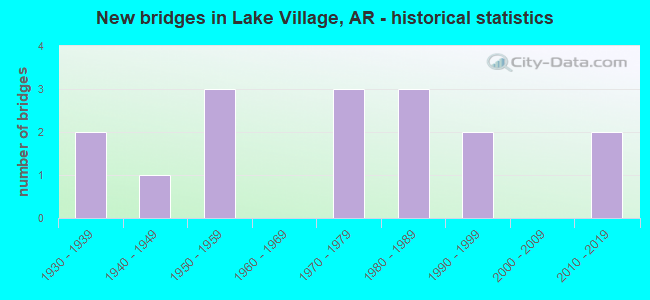
- New bridges - historical statistics
- 21930-1939
- 11940-1949
- 31950-1959
- 31970-1979
- 31980-1989
- 21990-1999
- 22010-2019


- Bridge Condition - Deck
- 28.6%Very good
- 42.9%Good
- 28.6%Satisfactory

- Bridge Condition - Superstructure
- 14.3%Excellent
- 7.1%Very good
- 57.1%Good
- 7.1%Satisfactory
- 7.1%Fair
- 7.1%Poor

- Bridge Condition - Substructure
- 14.3%Excellent
- 7.1%Very good
- 64.3%Good
- 7.1%Satisfactory
- 7.1%Fair

- Bridge Condition - Channel
- 20.0%Very good
- 73.3%Good
- 6.7%Satisfactory

- Bridge Condition - Culverts
- 50.0%Very good
- 50.0%Good
Find on map >> Show street view
Structure Number: 2072, Location: 0.5 Mi N SH144-LakeVillag (Lat: 33.395472, Lng: -91.312522), Route carried "on" structure: US 65, Year Built: 1938, Year Reconstructed: 1989, Status: Open, Structure Length: 4.63m (15.19ft), Average Daily Traffic: 6,100 (year 2018), Truck Traffic: 24%, Average Future Daily Traffic: 6,318 (year 2028), Design Load: HS 20, Features Intersected: Swift Bayou
Minimum Vertical Clearance: 30+ m (98+ ft), Kilometerpoint: 19.972, Lanes on structure: 4, Base Highway Network: Yes, Owner: State Highway Agency, Approaching Roadway Width: 23.8m (78.1ft), Skew: 32 degrees, Material/Design: Steel, Design/Construction: Stringer/Multi-beam, Number Of Spans In Main Unit: 3, Length of Maximum Span: 15.2m (49.9ft), Curb-To-Curb Width: 21.6m (70.9ft), Out-to-Out Width: 22.9m (75.1ft)
Condition: Deck: Very good, Superstructure: Good, Substructure: Good, Channel: Good, Operating Rating: 54.4 metric tons, Method Used To Determine Operating Rating: Load Factor (LF), Inventory Rating: 32.7 metric tons, Method Used To Determine Inventory Rating: Load Factor (LF), Structural Evaluation: Better than present minimum criteria, Deck Geometry: Superior to present desirable criteria, Waterway Adequacy: Equal to present desirable criteria, Approach Roadway Alignment: Equal to present desirable criteria, Designated Inspection Frequency: Every 24 months, Critical Feature Inspection Frequency: Every 24 months, Inspection Date: March 2021, Deck Structure Type: Concrete Cast-file-Place, Wearing Surface/Protective System: Wearing Surface: Monolithic Concrete, Deck Protection: Epoxy Coated Reinforcing
Find on map >> Show street view
Structure Number: 2352, Location: 2.7 Mi W US65-LakeVillage (Lat: 33.314478, Lng: -91.334408), Route carried "on" structure: US 82, Year Built: 1950, Status: Open, Structure Length: 6.95m (22.80ft), Average Daily Traffic: 2,900 (year 2018), Truck Traffic: 1%, Average Future Daily Traffic: 3,576 (year 2028), Design Load: H 20, Features Intersected: Bayou Macon
Minimum Vertical Clearance: 30+ m (98+ ft), Kilometerpoint: 11.748, Lanes on structure: 2, Base Highway Network: Yes, Owner: State Highway Agency, Approaching Roadway Width: 9.8m (32.2ft), Material/Design: Steel, Design/Construction: Stringer/Multi-beam, Number Of Spans In Main Unit: 5, Length of Maximum Span: 13.7m (44.9ft), Curb or Sidewalk Widths: Left: 0.5m (1.6ft), Right: 0.5m (1.6ft), Curb-To-Curb Width: 7.9m (25.9ft), Out-to-Out Width: 9.0m (29.5ft)
Condition: Deck: Satisfactory, Superstructure: Poor, Substructure: Good, Channel: Satisfactory, Operating Rating: 41.7 metric tons, Method Used To Determine Operating Rating: Load Factor (LF), Inventory Rating: 24.5 metric tons, Method Used To Determine Inventory Rating: Load Factor (LF), Structural Evaluation: Meets minimum limits, Deck Geometry: High priority of corrective action, Waterway Adequacy: Equal to present desirable criteria, Approach Roadway Alignment: Equal to present desirable criteria, Length Of Structure Improvement: 7.99m (26.21ft), Designated Inspection Frequency: Every 24 months, Critical Feature Inspection Frequency: Every 24 months, Other Special Inspection Frequency: Every 24 months, Inspection Date: May 2021, Other Special Inspection Date: June 2020, Roadway Improvement Cost: $235,000, Total Project Cost: $830,000, Deck Structure Type: Concrete Cast-file-Place, Wearing Surface/Protective System: Wearing Surface: Bituminous
Find on map >> Show street view
Structure Number: 2358, Location: 1.0 M W US 65-LakeVillage (Lat: 33.324094, Lng: -91.308386), Route carried "on" structure: US 82, Year Built: 1950, Status: Open, Structure Length: 1.31m (4.30ft), Average Daily Traffic: 2,900 (year 2018), Truck Traffic: 1%, Average Future Daily Traffic: 3,576 (year 2028), Design Load: H 20, Features Intersected: Little Lake Relief
Minimum Vertical Clearance: 30+ m (98+ ft), Kilometerpoint: 14.404, Lanes on structure: 2, Base Highway Network: Yes, Owner: State Highway Agency, Approaching Roadway Width: 10.4m (34.1ft), Material/Design: Concrete, Design/Construction: Slab, Number Of Spans In Main Unit: 2, Length of Maximum Span: 6.4m (21.0ft), Curb or Sidewalk Widths: Left: 0.3m (1.0ft), Right: 0.3m (1.0ft), Curb-To-Curb Width: 11.6m (38.1ft), Out-to-Out Width: 12.7m (41.7ft)
Condition: Deck: Satisfactory, Superstructure: Satisfactory, Substructure: Good, Channel: Good, Operating Rating: 46.3 metric tons, Method Used To Determine Operating Rating: Load Factor (LF), Inventory Rating: 28.1 metric tons, Method Used To Determine Inventory Rating: Load Factor (LF), Structural Evaluation: Equal to present minimum criteria, Deck Geometry: Somewhat better than minimum adequacy, Waterway Adequacy: Equal to present desirable criteria, Approach Roadway Alignment: Equal to present desirable criteria, Designated Inspection Frequency: Every 24 months, Critical Feature Inspection Frequency: Every 24 months, Inspection Date: April 2021, Deck Structure Type: Concrete Cast-file-Place, Wearing Surface/Protective System: Wearing Surface: Bituminous
Find on map >> Show street view
Structure Number: 433, Location: 0.53 Mi W SH 159-Jennie (Lat: 33.256753, Lng: -91.294483), Route carried "on" structure: County highway 22, Year Built: 1977, Status: Open, Structure Length: 5.30m (17.39ft), Average Daily Traffic: 240 (year 2018), Truck Traffic: 1%, Average Future Daily Traffic: 191 (year 2007), Design Load: H 15, Features Intersected: Macon Bayou
Minimum Vertical Clearance: 30+ m (98+ ft), Kilometerpoint: 0.853, Lanes on structure: 2, Owner: County Highway Agency, Approaching Roadway Width: 7.3m (24.0ft), Material/Design: Steel, Design/Construction: Stringer/Multi-beam, Number Of Spans In Main Unit: 4, Length of Maximum Span: 13.1m (43.0ft), Curb-To-Curb Width: 7.9m (25.9ft), Out-to-Out Width: 8.8m (28.9ft)
Condition: Deck: Good, Superstructure: Good, Substructure: Good, Channel: Good, Operating Rating: 42.6 metric tons, Method Used To Determine Operating Rating: Load Factor (LF), Inventory Rating: 25.4 metric tons, Method Used To Determine Inventory Rating: Load Factor (LF), Structural Evaluation: Equal to present minimum criteria, Deck Geometry: Somewhat better than minimum adequacy, Waterway Adequacy: Equal to present desirable criteria, Approach Roadway Alignment: Equal to present desirable criteria, Designated Inspection Frequency: Every 24 months, Critical Feature Inspection Frequency: Every 24 months, Inspection Date: Febuary 2022, Deck Structure Type: Concrete Cast-file-Place, Wearing Surface/Protective System: Wearing Surface: Monolithic Concrete
Find on map >> Show street view
Structure Number: 4512, Location: 2.39 Mi W US65-LakeVllage (Lat: 33.284986, Lng: -91.321603), Route carried "on" structure: County highway 280, Year Built: 1985, Status: Open, Structure Length: 3.26m (10.70ft), Average Daily Traffic: 660 (year 2018), Truck Traffic: 1%, Average Future Daily Traffic: 111 (year 2007), Design Load: H 20, Features Intersected: Bayou Macon
Minimum Vertical Clearance: 30+ m (98+ ft), Kilometerpoint: 3.846, Lanes on structure: 2, Owner: County Highway Agency, Approaching Roadway Width: 8.5m (27.9ft), Material/Design: Concrete, Design/Construction: Channel Beam, Number Of Spans In Main Unit: 5, Length of Maximum Span: 9.4m (30.8ft), Curb-To-Curb Width: 8.5m (27.9ft), Out-to-Out Width: 9.4m (30.8ft)
Condition: Deck: Very good, Superstructure: Very good, Substructure: Very good, Channel: Good, Operating Rating: 54.4 metric tons, Method Used To Determine Operating Rating: Load Factor (LF), Inventory Rating: 32.7 metric tons, Method Used To Determine Inventory Rating: Load Factor (LF), Structural Evaluation: Equal to present desirable criteria, Deck Geometry: Somewhat better than minimum adequacy, Waterway Adequacy: Equal to present desirable criteria, Approach Roadway Alignment: Equal to present minimum criteria, Designated Inspection Frequency: Every 24 months, Critical Feature Inspection Frequency: Every 24 months, Inspection Date: April 2020, Deck Structure Type: Concrete Precast Panels, Wearing Surface/Protective System: Wearing Surface: Monolithic Concrete
Find on map >> Show street view
Structure Number: 4631, Location: 0.12 Mi E SH 144 (Lat: 33.367578, Lng: -91.255153), Route carried "on" structure: County highway 69, Year Built: 1990, Status: Open, Structure Length: 3.72m (12.20ft), Average Daily Traffic: 120 (year 1987), Truck Traffic: 1%, Average Future Daily Traffic: 143 (year 2007), Design Load: HS 20, Features Intersected: Lake Chicot
Minimum Vertical Clearance: 30+ m (98+ ft), Kilometerpoint: 0.193, Lanes on structure: 2, Owner: County Highway Agency, Approaching Roadway Width: 6.7m (22.0ft), Material/Design: Steel, Design/Construction: Stringer/Multi-beam, Number Of Spans In Main Unit: 3, Length of Maximum Span: 12.2m (40.0ft), Curb-To-Curb Width: 9.1m (29.9ft), Out-to-Out Width: 10.0m (32.8ft)
Condition: Deck: Good, Superstructure: Good, Substructure: Satisfactory, Channel: Good, Operating Rating: 54.4 metric tons, Method Used To Determine Operating Rating: Load Factor (LF), Inventory Rating: 32.7 metric tons, Method Used To Determine Inventory Rating: Load Factor (LF), Structural Evaluation: Equal to present minimum criteria, Deck Geometry: Equal to present minimum criteria, Waterway Adequacy: Equal to present desirable criteria, Approach Roadway Alignment: Equal to present desirable criteria, Designated Inspection Frequency: Every 24 months, Critical Feature Inspection Frequency: Every 24 months, Inspection Date: March 2020, Deck Structure Type: Concrete Cast-file-Place, Wearing Surface/Protective System: Wearing Surface: Monolithic Concrete
Find on map >> Show street view
Structure Number: 5417, Location: 2.2 M N US65,LakeVillage (Lat: 33.351711, Lng: -91.269950), Route carried "on" structure: State highway 144, Year Built: 1973, Status: Open, Structure Length: 7.38m (24.21ft), Average Daily Traffic: 2,300 (year 2018), Truck Traffic: 3%, Average Future Daily Traffic: 2,742 (year 2028), Design Load: HS 20, Features Intersected: Cove of Lake Chicot
Minimum Vertical Clearance: 30+ m (98+ ft), Kilometerpoint: 3.589, Lanes on structure: 2, Owner: State Highway Agency, Approaching Roadway Width: 8.5m (27.9ft), Material/Design: Steel, Design/Construction: Stringer/Multi-beam, Number Of Spans In Main Unit: 4, Length of Maximum Span: 18.3m (60.0ft), Curb-To-Curb Width: 9.1m (29.9ft), Out-to-Out Width: 10.1m (33.1ft)
Condition: Deck: Satisfactory, Superstructure: Good, Substructure: Good, Channel: Good, Operating Rating: 54.4 metric tons, Method Used To Determine Operating Rating: Load Factor (LF), Inventory Rating: 32.7 metric tons, Method Used To Determine Inventory Rating: Load Factor (LF), Structural Evaluation: Better than present minimum criteria, Deck Geometry: Meets minimum limits, Waterway Adequacy: Equal to present desirable criteria, Approach Roadway Alignment: Equal to present desirable criteria, Designated Inspection Frequency: Every 24 months, Critical Feature Inspection Frequency: Every 24 months, Inspection Date: March 2020, Deck Structure Type: Concrete Cast-file-Place, Wearing Surface/Protective System: Wearing Surface: Monolithic Concrete
Find on map >> Show street view
Structure Number: 5418, Location: 3.7 Mi E US 65 (Lat: 33.368989, Lng: -91.256169), Route carried "on" structure: State highway 144, Year Built: 1973, Status: Open, Structure Length: 8.44m (27.69ft), Average Daily Traffic: 1,840 (year 2018), Truck Traffic: 1%, Average Future Daily Traffic: 2,384 (year 2028), Design Load: HS 20, Features Intersected: Connerly Bayou
Minimum Vertical Clearance: 30+ m (98+ ft), Kilometerpoint: 5.938, Lanes on structure: 2, Owner: State Highway Agency, Approaching Roadway Width: 9.1m (29.9ft), Material/Design: Steel, Design/Construction: Stringer/Multi-beam, Number Of Spans In Main Unit: 5, Length of Maximum Span: 16.8m (55.1ft), Curb-To-Curb Width: 9.1m (29.9ft), Out-to-Out Width: 10.1m (33.1ft)
Condition: Deck: Good, Superstructure: Good, Substructure: Good, Channel: Good, Operating Rating: 54.4 metric tons, Method Used To Determine Operating Rating: Load Factor (LF), Inventory Rating: 32.7 metric tons, Method Used To Determine Inventory Rating: Load Factor (LF), Structural Evaluation: Better than present minimum criteria, Deck Geometry: Somewhat better than minimum adequacy, Waterway Adequacy: Equal to present desirable criteria, Approach Roadway Alignment: Equal to present desirable criteria, Designated Inspection Frequency: Every 24 months, Critical Feature Inspection Frequency: Every 24 months, Inspection Date: March 2020, Deck Structure Type: Concrete Cast-file-Place, Wearing Surface/Protective System: Wearing Surface: Monolithic Concrete
Find on map >> Show street view
Structure Number: 7338, Location: 5.10 Mi NE US65-LkVillage (Lat: 33.378708, Lng: -91.235778), Route carried "on" structure: State highway 144, Year Built: 2015, Status: Open, Structure Length: 3.47m (11.38ft), Average Daily Traffic: 1,029 (year 2018), Truck Traffic: 9%, Average Future Daily Traffic: 900 (year 2035), Design Load: HL 93, Features Intersected: Johnson Creek
Minimum Vertical Clearance: 30.44m (99.87ft), Kilometerpoint: 8.208, Lanes on structure: 2, Owner: State Highway Agency, Approaching Roadway Width: 9.1m (29.9ft), Material/Design: Steel continuous, Design/Construction: Stringer/Multi-beam, Number Of Spans In Main Unit: 3, Length of Maximum Span: 13.7m (44.9ft), Curb-To-Curb Width: 9.1m (29.9ft), Out-to-Out Width: 10.1m (33.1ft)
Condition: Deck: Very good, Superstructure: Excellent, Substructure: Excellent, Channel: Good, Operating Rating: 36.3 metric tons, Method Used To Determine Operating Rating: Load and Resistance Factor (LRFR), Inventory Rating: 28.1 metric tons, Method Used To Determine Inventory Rating: Load and Resistance Factor (LRFR), Structural Evaluation: Better than present minimum criteria, Deck Geometry: Somewhat better than minimum adequacy, Waterway Adequacy: Equal to present desirable criteria, Approach Roadway Alignment: Equal to present desirable criteria, Designated Inspection Frequency: Every 24 months, Critical Feature Inspection Frequency: Every 24 months, Inspection Date: August 2020, Deck Structure Type: Concrete Cast-file-Place, Wearing Surface/Protective System: Wearing Surface: Monolithic Concrete
Find on map >> Show street view
Structure Number: 7339, Location: 5.91 Mi NE US65-LkVillage (Lat: 33.380519, Lng: -91.222078), Route carried "on" structure: State highway 144, Year Built: 2015, Status: Open, Structure Length: 4.30m (14.11ft), Average Daily Traffic: 1,029 (year 2018), Truck Traffic: 9%, Average Future Daily Traffic: 900 (year 2035), Design Load: HL 93, Features Intersected: Ferry Bayou
Minimum Vertical Clearance: 30+ m (98+ ft), Kilometerpoint: 9.511, Lanes on structure: 2, Owner: State Highway Agency, Approaching Roadway Width: 9.1m (29.9ft), Material/Design: Steel continuous, Design/Construction: Stringer/Multi-beam, Number Of Spans In Main Unit: 3, Length of Maximum Span: 17.1m (56.1ft), Curb-To-Curb Width: 9.1m (29.9ft), Out-to-Out Width: 10.1m (33.1ft)
Condition: Deck: Very good, Superstructure: Excellent, Substructure: Excellent, Channel: Very good, Operating Rating: 37.2 metric tons, Method Used To Determine Operating Rating: Load and Resistance Factor (LRFR), Inventory Rating: 29.0 metric tons, Method Used To Determine Inventory Rating: Load and Resistance Factor (LRFR), Structural Evaluation: Better than present minimum criteria, Deck Geometry: Somewhat better than minimum adequacy, Waterway Adequacy: Equal to present desirable criteria, Approach Roadway Alignment: Equal to present desirable criteria, Designated Inspection Frequency: Every 24 months, Critical Feature Inspection Frequency: Every 24 months, Inspection Date: August 2020, Deck Structure Type: Concrete Cast-file-Place, Wearing Surface/Protective System: Wearing Surface: Monolithic Concrete
Find on map >> Show street view
Structure Number: 21227, Location: 0.37 Mi W US65-LakeVillge (Lat: 33.347183, Lng: -91.298761), Route carried "on" structure: County highway 317, Year Built: 1992, Status: Posted for load, Structure Length: 1.25m (4.10ft), Average Daily Traffic: 186 (year 2018), Truck Traffic: 1%, Average Future Daily Traffic: 32 (year 2007), Features Intersected: Little Lake Bayou
Minimum Vertical Clearance: 30+ m (98+ ft), Kilometerpoint: 0.595, Lanes on structure: 2, Owner: County Highway Agency, Approaching Roadway Width: 4.9m (16.1ft), Material/Design: Steel, Design/Construction: Orthotropic, Number Of Spans In Main Unit: 1, Length of Maximum Span: 9.8m (32.2ft), Curb or Sidewalk Widths: Left: 0.1m (0.3ft), Right: 0.1m (0.3ft), Curb-To-Curb Width: 5.3m (17.4ft), Out-to-Out Width: 5.5m (18.0ft)
Condition: Deck: Satisfactory, Superstructure: Fair, Substructure: Fair, Channel: Good, Operating Rating: 36.3 metric tons, Method Used To Determine Operating Rating: Load Factor (LF), Inventory Rating: 21.8 metric tons, Method Used To Determine Inventory Rating: Load Factor (LF), Structural Evaluation: Somewhat better than minimum adequacy, Waterway Adequacy: Equal to present minimum criteria, Approach Roadway Alignment: Equal to present minimum criteria, Length Of Structure Improvement: 1.98m (6.50ft), Designated Inspection Frequency: Every 12 months, Critical Feature Inspection Frequency: Every 12 months, Inspection Date: May 2021, Critical Feature Inspection Date: May 2021, Roadway Improvement Cost: $109,000, Total Project Cost: $230,000, Deck Structure Type: Steel plate, Wearing Surface/Protective System: Wearing Surface: Gravel
Find on map >> Show street view
Structure Number: A2073, Location: 2.2 Mi N US82-LakeVillage (Lat: 33.361358, Lng: -91.297731), Route carried "on" structure: US 65, Year Built: 1938, Year Reconstructed: 1989, Status: Open, Structure Length: 3.17m (10.40ft), Average Daily Traffic: 6,900 (year 2018), Truck Traffic: 1%, Average Future Daily Traffic: 7,272 (year 2028), Design Load: HS 20, Features Intersected: Little Lake Bayou
Minimum Vertical Clearance: 30+ m (98+ ft), Kilometerpoint: 23.979, Lanes on structure: 4, Base Highway Network: Yes, Owner: State Highway Agency, Approaching Roadway Width: 23.8m (78.1ft), Skew: 30 degrees, Material/Design: Steel, Design/Construction: Stringer/Multi-beam, Number Of Spans In Main Unit: 3, Length of Maximum Span: 10.4m (34.1ft), Curb-To-Curb Width: 21.6m (70.9ft), Out-to-Out Width: 22.9m (75.1ft)
Condition: Deck: Good, Superstructure: Good, Substructure: Good, Channel: Good, Operating Rating: 53.5 metric tons, Method Used To Determine Operating Rating: Load Factor (LF), Inventory Rating: 31.8 metric tons, Method Used To Determine Inventory Rating: Load Factor (LF), Structural Evaluation: Better than present minimum criteria, Deck Geometry: Superior to present desirable criteria, Waterway Adequacy: Equal to present desirable criteria, Approach Roadway Alignment: Equal to present desirable criteria, Designated Inspection Frequency: Every 24 months, Critical Feature Inspection Frequency: Every 24 months, Inspection Date: March 2021, Deck Structure Type: Concrete Cast-file-Place, Wearing Surface/Protective System: Wearing Surface: Monolithic Concrete
Find on map >> Show street view
Structure Number: M1206, Location: 0.9 MI S US 82-LakeVillag (Lat: 33.263544, Lng: -91.251886), Route carried "on" structure: US 65, Year Built: 1944, Status: Open, Structure Length: 0.64m (2.10ft), Average Daily Traffic: 4,100 (year 2018), Truck Traffic: 1%, Average Future Daily Traffic: 4,800 (year 2038), Features Intersected: Ditch
Minimum Vertical Clearance: 30+ m (98+ ft), Kilometerpoint: 9.189, Lanes on structure: 2, Base Highway Network: Yes, Owner: State Highway Agency, Approaching Roadway Width: 9.8m (32.2ft), Material/Design: Concrete, Design/Construction: Culvert, Number Of Spans In Main Unit: 2, Length of Maximum Span: 3.0m (9.8ft)
Condition: Channel: Good, Culverts: Good, Operating Rating: 39.9 metric tons, Method Used To Determine Operating Rating: Load Factor (LF), Inventory Rating: 23.6 metric tons, Method Used To Determine Inventory Rating: Load Factor (LF), Structural Evaluation: Equal to present minimum criteria, Waterway Adequacy: Equal to present desirable criteria, Approach Roadway Alignment: Equal to present desirable criteria, Designated Inspection Frequency: Every 24 months, Critical Feature Inspection Frequency: Every 24 months, Inspection Date: May 2020
Find on map >> Show street view
Structure Number: X0396, Location: 0.57 MI E US65-McMillJnct (Lat: 33.387256, Lng: -91.298583), Route carried "on" structure: State highway 257, Year Built: 1980, Status: Open, Structure Length: 0.76m (2.49ft), Average Daily Traffic: 650 (year 2018), Truck Traffic: 1%, Average Future Daily Traffic: 572 (year 2028), Design Load: H 20, Features Intersected: Ditch
Minimum Vertical Clearance: 30+ m (98+ ft), Kilometerpoint: 0.917, Lanes on structure: 2, Owner: State Highway Agency, Approaching Roadway Width: 8.5m (27.9ft), Skew: 3 degrees, Material/Design: Concrete, Design/Construction: Culvert, Number Of Spans In Main Unit: 2, Length of Maximum Span: 3.0m (9.8ft)
Condition: Channel: Very good, Culverts: Very good, Operating Rating: 41.7 metric tons, Method Used To Determine Operating Rating: Load Factor (LF), Inventory Rating: 25.4 metric tons, Method Used To Determine Inventory Rating: Load Factor (LF), Structural Evaluation: Equal to present minimum criteria, Waterway Adequacy: Equal to present desirable criteria, Approach Roadway Alignment: Equal to present desirable criteria, Designated Inspection Frequency: Every 48 months, Critical Feature Inspection Frequency: Every 24 months, Inspection Date: April 2019
Find on map >> Show street view
Structure Number: CEPMVKAR000001, Location: 1.5MI.N.OF MOUNTAIN PINE (Lat: 34.571092, Lng: -93.194661), Route carried "on" structure: ServiceFederal lands road , Year Built: 1953, Status: Open, Structure Length: 0.91m (2.99ft), Average Daily Traffic: 700 (year 2020), Truck Traffic: 5%, Average Future Daily Traffic: 1,350 (year 2036), Design Load: HS 20, Features Intersected: L.OUACHITA PWRPL CO2 RM, Facility Carried by Structure: Blakely Dam Road
Minimum Vertical Clearance: 30+ m (98+ ft), Kilometerpoint: 0.000, Lanes on structure: 2, Owner: Corps of Engineers (Civil), Approaching Roadway Width: 6.7m (22.0ft), Material/Design: Concrete, Design/Construction: Stringer/Multi-beam, Number Of Spans In Main Unit: 1, Length of Maximum Span: 9.1m (29.9ft), Curb-To-Curb Width: 6.7m (22.0ft), Out-to-Out Width: 7.3m (24.0ft)
Condition: Deck: Good, Superstructure: Good, Substructure: Good, Operating Rating: 47.0 metric tons, Method Used To Determine Operating Rating: Load and Resistance Factor Rating (LRFR) rating reported by rating factor(RF) method using HL-93 loadings, Inventory Rating: 36.3 metric tons, Method Used To Determine Inventory Rating: Load and Resistance Factor Rating (LRFR) rating reported by rating factor(RF) method using HL-93 loadings, Structural Evaluation: Better than present minimum criteria, Deck Geometry: Meets minimum limits, Approach Roadway Alignment: Equal to present desirable criteria, Length Of Structure Improvement: 0.91m (2.99ft), Designated Inspection Frequency: Every 24 months, Inspection Date: July 2020, Deck Structure Type: Concrete Cast-file-Place, Wearing Surface/Protective System: Wearing Surface: Bituminous
Find on map >> Show street view
Structure Number: CEPMVKAR0000011, Location: LK.CHICOT PUMPING STATION (Lat: 33.431653, Lng: -91.240283), Route carried "on" structure: ServiceOther road , Year Built: 1980, Status: Open, Structure Length: 12.95m (42.49ft), Average Daily Traffic: 240 (year 2020), Truck Traffic: 1%, Average Future Daily Traffic: 250 (year 2040), Design Load: HS 20, Features Intersected: CONNERLY BAYOU, Facility Carried by Structure: LEVEE ROAD
Minimum Vertical Clearance: 30+ m (98+ ft), Kilometerpoint: 0.000, Lanes on structure: 2, Owner: Corps of Engineers (Civil), Approaching Roadway Width: 6.7m (22.0ft), Material/Design: Concrete, Design/Construction: Slab, Number Of Spans In Main Unit: 15, Length of Maximum Span: 9.7m (31.8ft), Curb or Sidewalk Widths: Left: 0.4m (1.3ft), Right: 0.4m (1.3ft), Curb-To-Curb Width: 7.3m (24.0ft), Out-to-Out Width: 8.1m (26.6ft)
Condition: Deck: Good, Superstructure: Good, Substructure: Good, Channel: Very good, Operating Rating: 97.2 metric tons, Method Used To Determine Operating Rating: Load and Resistance Factor Rating (LRFR) rating reported by rating factor(RF) method using HL-93 loadings, Inventory Rating: 97.2 metric tons, Method Used To Determine Inventory Rating: Load and Resistance Factor Rating (LRFR) rating reported by rating factor(RF) method using HL-93 loadings, Structural Evaluation: Better than present minimum criteria, Deck Geometry: Somewhat better than minimum adequacy, Waterway Adequacy: Superior to present desirable criteria, Approach Roadway Alignment: Equal to present minimum criteria, Length Of Structure Improvement: 21.71m (71.23ft), Designated Inspection Frequency: Every 24 months, Inspection Date: May 2020, Deck Structure Type: Concrete Cast-file-Place, Wearing Surface/Protective System: Wearing Surface: Monolithic Concrete