Bridge Statistics for Lake Wales, Florida (FL)
Condition, Traffic, Stress, Structural Evaluation, Project Costs
- National Bridge Inventory (NBI) Statistics
- 11Number of bridges
- 85ft / 25.8mTotal length
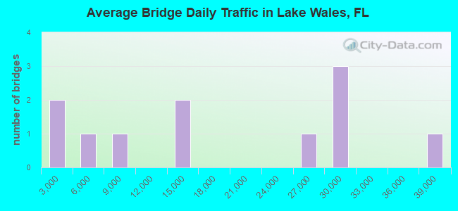
- 190,303Total average daily traffic
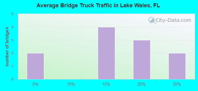
- 26,218Total average daily truck traffic
- National Bridge Inventory (NBI) Registered Bridges for Lake Wales
- No street view available for this location
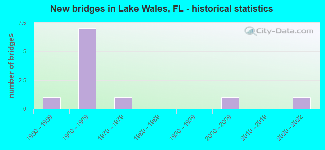
- New bridges - historical statistics
- 11950-1959
- 71960-1969
- 11970-1979
- 12000-2009
- 12020-2022
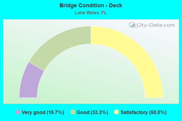
- Bridge Condition - Deck
- 16.7%Very good
- 33.3%Good
- 50.0%Satisfactory
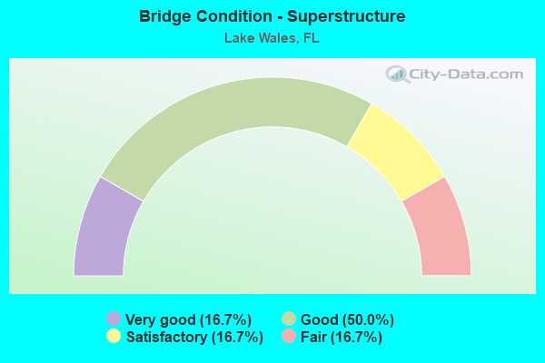
- Bridge Condition - Superstructure
- 16.7%Very good
- 50.0%Good
- 16.7%Satisfactory
- 16.7%Fair
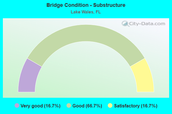
- Bridge Condition - Substructure
- 16.7%Very good
- 66.7%Good
- 16.7%Satisfactory
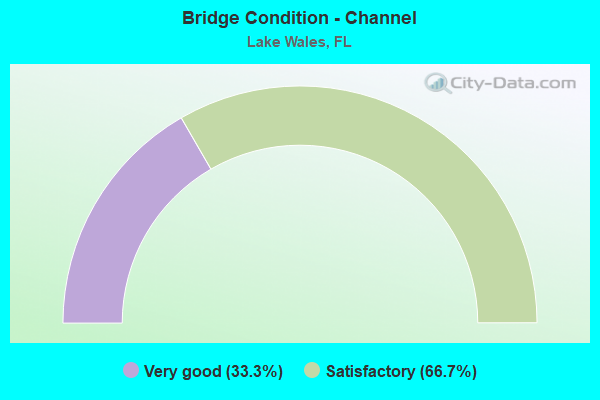
- Bridge Condition - Channel
- 33.3%Very good
- 66.7%Satisfactory
Find on map >> Show street view
Structure Number: 160018, Location: INTERSECT OF SR-60 US-27 (Lat: 27.897694, Lng: -81.599869), Route carried "on" structure: State highway 60, Year Built: 1966, Status: Open, Structure Length: 6.21m (20.37ft), Average Daily Traffic: 13,500 (year 2020), Truck Traffic: 20%, Average Future Daily Traffic: 23,422 (year 2042), Design Load: HS 20, Features Intersected: US-27 (SR-25)
Minimum Vertical Clearance: 30+ m (98+ ft), Kilometerpoint: 47.374, Lanes on structure: 3, Lanes under structure: 5, Base Highway Network: Yes, Owner: State Highway Agency, Approaching Roadway Width: 12.4m (40.7ft), Skew: 1 degrees, Material/Design: Prestressed concrete, Design/Construction: Stringer/Multi-beam, Number Of Spans In Main Unit: 4, Length of Maximum Span: 19.8m (65.0ft), Curb-To-Curb Width: 12.4m (40.7ft), Out-to-Out Width: 14.0m (45.9ft)
Condition: Deck: Satisfactory, Superstructure: Fair, Substructure: Good, Operating Rating: 67.5 metric tons, Method Used To Determine Operating Rating: Load Factor (LF), Inventory Rating: 42.1 metric tons, Method Used To Determine Inventory Rating: Load Factor (LF), Structural Evaluation: Somewhat better than minimum adequacy, Deck Geometry: Meets minimum limits, Underclear: Equal to present minimum criteria, Approach Roadway Alignment: Better than present minimum criteria, Designated Inspection Frequency: Every 24 months, Other Special Inspection Frequency: Every 12 months, Inspection Date: August 2020, Other Special Inspection Date: August 2021, Deck Structure Type: Concrete Cast-file-Place
Find on map >> Show street view
Structure Number: 160038, Location: 1.2 MI EAST OF US-27 (Lat: 27.894183, Lng: -81.581339), Route carried "on" structure: State highway 60, Year Built: 1966, Status: Open, Structure Length: 4.91m (16.11ft), Average Daily Traffic: 28,500 (year 2020), Truck Traffic: 16%, Average Future Daily Traffic: 49,448 (year 2042), Design Load: HS 20, Features Intersected: ALT. US-27 (SR-17)
Minimum Vertical Clearance: 30+ m (98+ ft), Kilometerpoint: 0.000, Lanes on structure: 4, Lanes under structure: 2, Base Highway Network: Yes, Owner: State Highway Agency, Approaching Roadway Width: 18.9m (62.0ft), Skew: 21 degrees, Material/Design: Prestressed concrete, Design/Construction: Stringer/Multi-beam, Number Of Spans In Main Unit: 3, Length of Maximum Span: 22.9m (75.1ft), Curb-To-Curb Width: 18.9m (62.0ft), Out-to-Out Width: 20.4m (66.9ft)
Condition: Deck: Good, Superstructure: Good, Substructure: Good, Operating Rating: 62.6 metric tons, Method Used To Determine Operating Rating: Allowable Stress (AS), Inventory Rating: 46.3 metric tons, Method Used To Determine Inventory Rating: Allowable Stress (AS), Structural Evaluation: Better than present minimum criteria, Deck Geometry: Equal to present minimum criteria, Underclear: Better than present minimum criteria, Approach Roadway Alignment: Better than present minimum criteria, Designated Inspection Frequency: Every 24 months, Inspection Date: August 2020, Deck Structure Type: Concrete Cast-file-Place
Find on map >> Show street view
Structure Number: 160134, Location: INTERSECT US-27 AND SR-60 (Lat: 27.897522, Lng: -81.599861), Route carried "on" structure: State highway 60, Year Built: 1966, Status: Open, Structure Length: 6.24m (20.47ft), Average Daily Traffic: 13,500 (year 2020), Truck Traffic: 20%, Average Future Daily Traffic: 23,422 (year 2042), Design Load: HS 20, Features Intersected: US-27 (SR-25)
Minimum Vertical Clearance: 30+ m (98+ ft), Kilometerpoint: 47.374, Lanes on structure: 2, Lanes under structure: 5, Base Highway Network: Yes, Owner: State Highway Agency, Approaching Roadway Width: 8.6m (28.2ft), Skew: 1 degrees, Material/Design: Prestressed concrete, Design/Construction: Stringer/Multi-beam, Number Of Spans In Main Unit: 4, Length of Maximum Span: 20.0m (65.6ft), Curb-To-Curb Width: 9.1m (29.9ft), Out-to-Out Width: 10.7m (35.1ft)
Condition: Deck: Satisfactory, Superstructure: Good, Substructure: Good, Operating Rating: 72.6 metric tons, Method Used To Determine Operating Rating: Allowable Stress (AS), Inventory Rating: 64.4 metric tons, Method Used To Determine Inventory Rating: Allowable Stress (AS), Structural Evaluation: Better than present minimum criteria, Deck Geometry: Meets minimum limits, Underclear: Equal to present minimum criteria, Approach Roadway Alignment: Better than present minimum criteria, Designated Inspection Frequency: Every 24 months, Inspection Date: August 2020, Deck Structure Type: Concrete Cast-file-Place
Find on map >> Show street view
Structure Number: 16015, Location: 2.4 MI. SOUTH OF SR-540 (Lat: 27.946139, Lng: -81.616167), Route carried "on" structure: US 27, Year Built: 1958, Year Reconstructed: 2004, Status: Open, Structure Length: 0.64m (2.10ft), Average Daily Traffic: 37,000 (year 2020), Truck Traffic: 11%, Average Future Daily Traffic: 64,195 (year 2042), Design Load: H 15, Features Intersected: PEACE CREEK SLOUGH
Minimum Vertical Clearance: 30+ m (98+ ft), Kilometerpoint: 5.646, Lanes on structure: 6, Base Highway Network: Yes, Owner: State Highway Agency, Approaching Roadway Width: 25.3m (83.0ft), Skew: 22 degrees, Material/Design: Concrete, Design/Construction: Culvert, Number Of Spans In Main Unit: 2, Length of Maximum Span: 3.2m (10.5ft)
Condition: Channel: Satisfactory, Culverts: Satisfactory, Inventory Rating: 62.0 metric tons, Method Used To Determine Inventory Rating: Load Factor (LF), Structural Evaluation: Equal to present minimum criteria, Waterway Adequacy: Better than present minimum criteria, Approach Roadway Alignment: Equal to present desirable criteria, Designated Inspection Frequency: Every 24 months, Underwater Inspection Frequency: Every 24 months, Inspection Date: Febuary 2022, Underwater Inspection Date: January 2022
Find on map >> Show street view
Structure Number: 160345, Location: 0.5 MI. NORTH OF SR-60 (Lat: 27.904881, Lng: -81.600800), Route carried "on" structure: US 27, Year Built: 2008, Status: Open, Structure Length: 2.96m (9.71ft), Average Daily Traffic: 29,500 (year 2020), Truck Traffic: 13%, Average Future Daily Traffic: 51,182 (year 2042), Design Load: HL 93, Features Intersected: CSXT RR
Minimum Vertical Clearance: 30+ m (98+ ft), Kilometerpoint: 0.806, Lanes on structure: 6, Base Highway Network: Yes, Owner: State Highway Agency, Approaching Roadway Width: 27.9m (91.5ft), Skew: 21 degrees, Material/Design: Prestressed concrete, Design/Construction: Stringer/Multi-beam, Number Of Spans In Main Unit: 1, Length of Maximum Span: 29.6m (97.1ft), Curb or Sidewalk Widths: Left: 2.4m (7.9ft), Right: 2.4m (7.9ft), Curb-To-Curb Width: 27.9m (91.5ft), Out-to-Out Width: 42.5m (139.4ft)
Condition: Deck: Good, Superstructure: Good, Substructure: Good, Inventory Rating: 58.9 metric tons, Method Used To Determine Inventory Rating: Load Factor (LF), Structural Evaluation: Better than present minimum criteria, Deck Geometry: Superior to present desirable criteria, Underclear: Meets minimum limits, Approach Roadway Alignment: Better than present minimum criteria, Designated Inspection Frequency: Every 24 months, Inspection Date: Febuary 2022, Deck Structure Type: Concrete Cast-file-Place
Find on map >> Show street view
Structure Number: 164338, Location: 0.2MI WEST OF US-27 (Lat: 27.956944, Lng: -81.625444), Route carried "on" structure: County highway 17A, Year Built: 1976, Status: Open, Structure Length: 2.44m (8.01ft), Average Daily Traffic: 6,600 (year 2020), Truck Traffic: 4%, Average Future Daily Traffic: 11,451 (year 2042), Features Intersected: PEACE CREEK DRAIN CANAL, Facility Carried by Structure: THOMPSON NURSERY
Minimum Vertical Clearance: 30+ m (98+ ft), Kilometerpoint: 10.911, Lanes on structure: 2, Owner: County Highway Agency, Approaching Roadway Width: 8.6m (28.2ft), Skew: 2 degrees, Material/Design: Prestressed concrete, Design/Construction: Channel Beam, Number Of Spans In Main Unit: 4, Length of Maximum Span: 6.1m (20.0ft), Curb-To-Curb Width: 8.6m (28.2ft), Out-to-Out Width: 9.3m (30.5ft)
Condition: Deck: Satisfactory, Superstructure: Satisfactory, Substructure: Satisfactory, Channel: Satisfactory, Operating Rating: 41.1 metric tons, Method Used To Determine Operating Rating: Load Factor (LF), Inventory Rating: 27.8 metric tons, Method Used To Determine Inventory Rating: Load Factor (LF), Structural Evaluation: Equal to present minimum criteria, Deck Geometry: High priority of replacement, Waterway Adequacy: Better than present minimum criteria, Approach Roadway Alignment: Equal to present desirable criteria, Designated Inspection Frequency: Every 24 months, Underwater Inspection Frequency: Every 23 months, Inspection Date: June 2021, Underwater Inspection Date: June 2021, Deck Structure Type: Concrete Cast-file-Place
Find on map >> Show street view
Structure Number: 164555, Location: 3.7 MI N/O CR-630 E (Lat: 27.812056, Lng: -81.444167), Route carried "on" structure: City street , Year Built: 2021, Status: Open, Structure Length: 2.38m (7.81ft), Average Daily Traffic: 912 (year 2021), Truck Traffic: 11%, Average Future Daily Traffic: 1,582 (year 2041), Design Load: HL 93, Features Intersected: TIGER CREEK, Facility Carried by Structure: WALK-IN-WATER RD
Minimum Vertical Clearance: 30+ m (98+ ft), Kilometerpoint: 0.000, Lanes on structure: 2, Owner: County Highway Agency, Approaching Roadway Width: 12.3m (40.4ft), Material/Design: Prestressed concrete, Design/Construction: Stringer/Multi-beam, Number Of Spans In Main Unit: 1, Length of Maximum Span: 23.8m (78.1ft), Curb-To-Curb Width: 12.3m (40.4ft), Out-to-Out Width: 13.0m (42.7ft)
Condition: Deck: Very good, Superstructure: Very good, Substructure: Very good, Channel: Very good, Operating Rating: 50.0 metric tons, Method Used To Determine Operating Rating: Load and Resistance Factor (LRFR), Inventory Rating: 38.6 metric tons, Method Used To Determine Inventory Rating: Load and Resistance Factor (LRFR), Structural Evaluation: Equal to present desirable criteria, Deck Geometry: Superior to present desirable criteria, Waterway Adequacy: Equal to present desirable criteria, Approach Roadway Alignment: Equal to present minimum criteria, Designated Inspection Frequency: Every 24 months, Inspection Date: November 2021, Deck Structure Type: Concrete Cast-file-Place
Find on map >> Show street view
Structure Number: 160018, Location: INTERSECT OF SR-60 US-27 (Lat: 27.897694, Lng: -81.599869), Route carried "under" structure: US 27, Year Built: 1966, Structure Length: 0. m, Average Daily Traffic: 29,500 (year 2020), Truck Traffic: 13%, Features Intersected: US-27 (SR-25), Facility Carried by Structure: SR-60 WB
Minimum Vertical Clearance: 4.75m (15.58ft), Kilometerpoint: 0.002, Lanes on structure: 3, Lanes under structure: 5, Material/Design: Prestressed concrete, Design/Construction: Stringer/Multi-beam, Length of Maximum Span: 19.8m (65.0ft)
Find on map >> Show street view
Structure Number: 160038, Location: 1.2 MI EAST OF US-27 (Lat: 27.894183, Lng: -81.581339), Route carried "under" structure: Alternate US 27, Year Built: 1966, Structure Length: 0. m, Average Daily Traffic: 4,900 (year 2020), Truck Traffic: 4%, Features Intersected: ALT. US-27 (SR-17), Facility Carried by Structure: SR-60
Minimum Vertical Clearance: 4.94m (16.21ft), Kilometerpoint: 30.257, Lanes on structure: 4, Lanes under structure: 2, Material/Design: Prestressed concrete, Design/Construction: Stringer/Multi-beam, Length of Maximum Span: 22.9m (75.1ft)
Find on map >> Show street view
Structure Number: 160134, Location: INTERSECT US-27 AND SR-60 (Lat: 27.897522, Lng: -81.599861), Route carried "under" structure: US 27, Year Built: 1966, Structure Length: 0. m, Average Daily Traffic: 24,191 (year 2020), Truck Traffic: 15%, Features Intersected: US-27 (SR-25), Facility Carried by Structure: SR-60 EB
Minimum Vertical Clearance: 4.75m (15.58ft), Kilometerpoint: 30.270, Lanes on structure: 2, Lanes under structure: 5, Material/Design: Prestressed concrete, Design/Construction: Stringer/Multi-beam, Length of Maximum Span: 20.0m (65.6ft)
Find on map >> Show street view
Structure Number: 160951, Location: 1.3 MI EAST OF US-27 (Lat: 27.894286, Lng: -81.580256), Route carried "under" structure: City street , Year Built: 1966, Structure Length: 0. m, Average Daily Traffic: 2,200 (year 2020), Truck Traffic: 15%, Features Intersected: CSX R/R & PALM AVE, Facility Carried by Structure: SR-60
Minimum Vertical Clearance: 4.72m (15.49ft), Kilometerpoint: 0.352, Lanes on structure: 4, Lanes under structure: 2, Material/Design: Prestressed concrete, Design/Construction: Stringer/Multi-beam, Length of Maximum Span: 18.6m (61.0ft)