Bridge Statistics for Lake Worth, Texas (TX)
Condition, Traffic, Stress, Structural Evaluation, Project Costs
- National Bridge Inventory (NBI) Statistics
- 13Number of bridges
- 161ft / 48.6mTotal length
- 374,341Total average daily traffic
- 20,070Total average daily truck traffic
- National Bridge Inventory (NBI) Registered Bridges for Lake Worth
- No street view available for this location
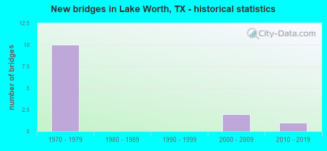
- New bridges - historical statistics
- 101970-1979
- 22000-2009
- 12010-2019


- Bridge Condition - Deck
- 16.7%Very good
- 83.3%Good

- Bridge Condition - Superstructure
- 33.3%Very good
- 50.0%Good
- 16.7%Satisfactory

- Bridge Condition - Substructure
- 16.7%Very good
- 66.7%Good
- 16.7%Satisfactory

- Bridge Condition - Channel
- 33.3%Good
- 66.7%Satisfactory

- Bridge Condition - Culverts
- 50.0%Good
- 50.0%Satisfactory
Find on map >> Show street view
Structure Number: 22200000814231, Location: 0.45 MI SW OF FM 1220 (Lat: 32.809153, Lng: -97.418772), Route carried "on" structure: ServiceInterstate 820, Year Built: 1976, Status: Open, Structure Length: 6.86m (22.51ft), Average Daily Traffic: 15,301 (year 2019), Truck Traffic: 8%, Average Future Daily Traffic: 13,070 (year 2035), Design Load: HS 20, Features Intersected: SH 199
Minimum Vertical Clearance: 30+ m (98+ ft), Kilometerpoint: 18.223, Lanes on structure: 2, Lanes under structure: 8, Owner: State Highway Agency, Approaching Roadway Width: 10.4m (34.1ft), Material/Design: Prestressed concrete, Design/Construction: Stringer/Multi-beam, Number Of Spans In Main Unit: 2, Number Of Approach Spans: 2, Length of Maximum Span: 24.4m (80.1ft), Curb-To-Curb Width: 10.4m (34.1ft), Out-to-Out Width: 10.9m (35.8ft)
Condition: Deck: Good, Superstructure: Satisfactory, Substructure: Good, Operating Rating: 54.4 metric tons, Method Used To Determine Operating Rating: Assigned rating based on Load Factor Design (LFD) reported in metric tons, Inventory Rating: 32.7 metric tons, Method Used To Determine Inventory Rating: Assigned rating based on Load Factor Design (LFD) reported in metric tons, Structural Evaluation: Equal to present minimum criteria, Deck Geometry: Meets minimum limits, Underclear: Equal to present minimum criteria, Approach Roadway Alignment: Equal to present desirable criteria, Designated Inspection Frequency: Every 24 months, Inspection Date: July 2021, Deck Structure Type: Concrete Cast-file-Place, Wearing Surface/Protective System: Wearing Surface: Bituminous
Find on map >> Show street view
Structure Number: 22200000814232, Location: 0.45 MI SW OF FM 1220 (Lat: 32.808983, Lng: -97.418447), Route carried "on" structure: Interstate 820, Year Built: 1976, Status: Open, Structure Length: 6.86m (22.51ft), Average Daily Traffic: 39,330 (year 2013), Truck Traffic: 6%, Average Future Daily Traffic: 55,060 (year 2033), Design Load: HS 20, Features Intersected: SH 199
Minimum Vertical Clearance: 30+ m (98+ ft), Kilometerpoint: 18.223, Lanes on structure: 3, Lanes under structure: 8, Base Highway Network: Yes, Owner: State Highway Agency, Approaching Roadway Width: 18.3m (60.0ft), Material/Design: Prestressed concrete, Design/Construction: Stringer/Multi-beam, Number Of Spans In Main Unit: 2, Number Of Approach Spans: 2, Length of Maximum Span: 24.4m (80.1ft), Curb-To-Curb Width: 18.3m (60.0ft), Out-to-Out Width: 18.8m (61.7ft)
Condition: Deck: Very good, Superstructure: Good, Substructure: Good, Operating Rating: 54.4 metric tons, Method Used To Determine Operating Rating: Assigned rating based on Load Factor Design (LFD) reported in metric tons, Inventory Rating: 32.7 metric tons, Method Used To Determine Inventory Rating: Assigned rating based on Load Factor Design (LFD) reported in metric tons, Structural Evaluation: Better than present minimum criteria, Deck Geometry: Better than present minimum criteria, Underclear: Equal to present minimum criteria, Approach Roadway Alignment: Equal to present desirable criteria, Designated Inspection Frequency: Every 24 months, Inspection Date: July 2021, Deck Structure Type: Concrete Cast-file-Place, Wearing Surface/Protective System: Wearing Surface: Bituminous
Find on map >> Show street view
Structure Number: 22200000814233, Location: 0.45 MI SW OF FM 1220 (Lat: 32.808931, Lng: -97.418347), Route carried "on" structure: Interstate 820, Year Built: 1976, Status: Open, Structure Length: 6.86m (22.51ft), Average Daily Traffic: 39,330 (year 2013), Truck Traffic: 6%, Average Future Daily Traffic: 55,060 (year 2033), Design Load: HS 20, Features Intersected: SH 199
Minimum Vertical Clearance: 30+ m (98+ ft), Kilometerpoint: 18.223, Lanes on structure: 3, Lanes under structure: 8, Base Highway Network: Yes, Owner: State Highway Agency, Approaching Roadway Width: 18.3m (60.0ft), Material/Design: Prestressed concrete, Design/Construction: Stringer/Multi-beam, Number Of Spans In Main Unit: 2, Number Of Approach Spans: 2, Length of Maximum Span: 24.4m (80.1ft), Curb-To-Curb Width: 18.3m (60.0ft), Out-to-Out Width: 18.8m (61.7ft)
Condition: Deck: Good, Superstructure: Very good, Substructure: Good, Operating Rating: 54.4 metric tons, Method Used To Determine Operating Rating: Assigned rating based on Load Factor Design (LFD) reported in metric tons, Inventory Rating: 32.7 metric tons, Method Used To Determine Inventory Rating: Assigned rating based on Load Factor Design (LFD) reported in metric tons, Structural Evaluation: Better than present minimum criteria, Deck Geometry: Better than present minimum criteria, Underclear: Equal to present minimum criteria, Approach Roadway Alignment: Equal to present desirable criteria, Designated Inspection Frequency: Every 24 months, Inspection Date: July 2021, Deck Structure Type: Concrete Cast-file-Place, Wearing Surface/Protective System: Wearing Surface: Bituminous
Find on map >> Show street view
Structure Number: 22200000814234, Location: 0.45 MI SW OF FM 1220 (Lat: 32.808753, Lng: -97.418039), Route carried "on" structure: ServiceInterstate 820, Year Built: 1976, Status: Open, Structure Length: 6.86m (22.51ft), Average Daily Traffic: 16,489 (year 2019), Truck Traffic: 8%, Average Future Daily Traffic: 13,070 (year 2035), Design Load: HS 20, Features Intersected: SH 199
Minimum Vertical Clearance: 30+ m (98+ ft), Kilometerpoint: 18.223, Lanes on structure: 2, Lanes under structure: 8, Base Highway Network: Yes, Owner: State Highway Agency, Approaching Roadway Width: 10.4m (34.1ft), Material/Design: Prestressed concrete, Design/Construction: Stringer/Multi-beam, Number Of Spans In Main Unit: 2, Number Of Approach Spans: 2, Length of Maximum Span: 24.4m (80.1ft), Curb-To-Curb Width: 10.4m (34.1ft), Out-to-Out Width: 10.9m (35.8ft)
Condition: Deck: Good, Superstructure: Good, Substructure: Good, Operating Rating: 54.4 metric tons, Method Used To Determine Operating Rating: Assigned rating based on Load Factor Design (LFD) reported in metric tons, Inventory Rating: 32.7 metric tons, Method Used To Determine Inventory Rating: Assigned rating based on Load Factor Design (LFD) reported in metric tons, Structural Evaluation: Better than present minimum criteria, Deck Geometry: Meets minimum limits, Underclear: Equal to present minimum criteria, Approach Roadway Alignment: Equal to present desirable criteria, Designated Inspection Frequency: Every 24 months, Inspection Date: July 2021, Deck Structure Type: Concrete Cast-file-Place, Wearing Surface/Protective System: Wearing Surface: Bituminous
Find on map >> Show street view
Structure Number: 22200000814285, Location: 0.5 MI N OF US 199 (Lat: 32.813733, Lng: -97.412944), Route carried "on" structure: State highway 1220, Year Built: 1976, Status: Open, Structure Length: 17.07m (56.00ft), Average Daily Traffic: 27,520 (year 2015), Truck Traffic: 11%, Average Future Daily Traffic: 38,530 (year 2035), Design Load: HS 20, Features Intersected: IH-820
Minimum Vertical Clearance: 30+ m (98+ ft), Kilometerpoint: 16.967, Lanes on structure: 4, Lanes under structure: 8, Base Highway Network: Yes, Owner: State Highway Agency, Approaching Roadway Width: 20.7m (67.9ft), Skew: 4 degrees, Material/Design: Prestressed concrete, Design/Construction: Stringer/Multi-beam, Number Of Spans In Main Unit: 2, Number Of Approach Spans: 4, Length of Maximum Span: 38.1m (125.0ft), Curb or Sidewalk Widths: Left: 0.7m (2.3ft), Right: 0.7m (2.3ft), Curb-To-Curb Width: 26.8m (87.9ft), Out-to-Out Width: 29.0m (95.1ft)
Condition: Deck: Good, Superstructure: Good, Substructure: Satisfactory, Operating Rating: 54.4 metric tons, Method Used To Determine Operating Rating: Assigned rating based on Load Factor Design (LFD) reported in metric tons, Inventory Rating: 32.7 metric tons, Method Used To Determine Inventory Rating: Assigned rating based on Load Factor Design (LFD) reported in metric tons, Structural Evaluation: Equal to present minimum criteria, Deck Geometry: Superior to present desirable criteria, Underclear: Equal to present minimum criteria, Approach Roadway Alignment: Equal to present desirable criteria, Designated Inspection Frequency: Every 24 months, Inspection Date: July 2021, Deck Structure Type: Concrete Cast-file-Place, Wearing Surface/Protective System: Wearing Surface: Bituminous
Find on map >> Show street view
Structure Number: 22200017105235, Location: 1.4 MI W OF IH-820 (Lat: 32.816983, Lng: -97.440736), Route carried "on" structure: State highway 199, Year Built: 2006, Status: Open, Structure Length: 0.73m (2.40ft), Average Daily Traffic: 19,000 (year 2015), Truck Traffic: 3%, Average Future Daily Traffic: 19,050 (year 2035), Design Load: HS 20, Features Intersected: TRIB TO LAKE WORTH
Minimum Vertical Clearance: 30+ m (98+ ft), Kilometerpoint: 13.662, Lanes on structure: 4, Owner: State Highway Agency, Approaching Roadway Width: 11.6m (38.1ft), Skew: 23 degrees, Material/Design: Concrete, Design/Construction: Culvert, Number Of Spans In Main Unit: 2, Length of Maximum Span: 2.7m (8.9ft)
Condition: Channel: Satisfactory, Culverts: Satisfactory, Operating Rating: 54.4 metric tons, Method Used To Determine Operating Rating: Assigned rating based on Load Factor Design (LFD) reported in metric tons, Inventory Rating: 32.7 metric tons, Method Used To Determine Inventory Rating: Assigned rating based on Load Factor Design (LFD) reported in metric tons, Structural Evaluation: Equal to present minimum criteria, Waterway Adequacy: Equal to present desirable criteria, Approach Roadway Alignment: Equal to present desirable criteria, Designated Inspection Frequency: Every 48 months, Inspection Date: August 2021
Find on map >> Show street view
Structure Number: 22200017105236, Location: .6 MI W OF IH-820 (Lat: 32.810075, Lng: -97.429308), Route carried "on" structure: ServiceState highway 199, Year Built: 2006, Status: Open, Structure Length: 0.88m (2.89ft), Average Daily Traffic: 10,114 (year 2019), Truck Traffic: 3%, Average Future Daily Traffic: 19,050 (year 2035), Design Load: HS 20, Features Intersected: TRIB TO LAKE WORTH
Minimum Vertical Clearance: 30+ m (98+ ft), Kilometerpoint: 15.070, Lanes on structure: 3, Owner: State Highway Agency, Approaching Roadway Width: 11.6m (38.1ft), Skew: 4 degrees, Material/Design: Concrete, Design/Construction: Culvert, Number Of Spans In Main Unit: 2, Length of Maximum Span: 3.0m (9.8ft)
Condition: Channel: Satisfactory, Culverts: Good, Operating Rating: 54.4 metric tons, Method Used To Determine Operating Rating: Assigned rating based on Load Factor Design (LFD) reported in metric tons, Inventory Rating: 32.7 metric tons, Method Used To Determine Inventory Rating: Assigned rating based on Load Factor Design (LFD) reported in metric tons, Structural Evaluation: Better than present minimum criteria, Waterway Adequacy: Equal to present desirable criteria, Approach Roadway Alignment: Equal to present desirable criteria, Designated Inspection Frequency: Every 48 months, Inspection Date: August 2021
Find on map >> Show street view
Structure Number: 22200R00240001, Location: 0.7 MI N IH820 SW SH199 (Lat: 32.807683, Lng: -97.442778), Route carried "on" structure: City street , Year Built: 2011, Status: Open, Structure Length: 2.44m (8.01ft), Average Daily Traffic: 3,397 (year 2019), Truck Traffic: 1%, Average Future Daily Traffic: 3,120 (year 2034), Design Load: HL 93, Features Intersected: TRIB TO LAKE WORTH, Facility Carried by Structure: SHAWNEE TRAIL
Minimum Vertical Clearance: 30+ m (98+ ft), Kilometerpoint: 0.402, Lanes on structure: 2, Owner: City or Municipal Highway Agency, Approaching Roadway Width: 9.4m (30.8ft), Material/Design: Prestressed concrete, Design/Construction: Slab, Number Of Spans In Main Unit: 3, Length of Maximum Span: 9.1m (29.9ft), Curb or Sidewalk Widths: Left: 1.8m (5.9ft), Right: 1.8m (5.9ft), Curb-To-Curb Width: 11.0m (36.1ft), Out-to-Out Width: 15.3m (50.2ft)
Condition: Deck: Good, Superstructure: Very good, Substructure: Very good, Channel: Good, Operating Rating: 54.4 metric tons, Method Used To Determine Operating Rating: Assigned ratings based on Load and Resistance Factor Design (LRFD) reported in metric tons, Inventory Rating: 32.7 metric tons, Method Used To Determine Inventory Rating: Assigned ratings based on Load and Resistance Factor Design (LRFD) reported in metric tons, Structural Evaluation: Equal to present desirable criteria, Deck Geometry: Somewhat better than minimum adequacy, Waterway Adequacy: Equal to present desirable criteria, Approach Roadway Alignment: Equal to present desirable criteria, Designated Inspection Frequency: Every 24 months, Inspection Date: Febuary 2020, Deck Structure Type: Concrete Cast-file-Place, Wearing Surface/Protective System: Deck Protection: Epoxy Coated Reinforcing
Find on map >> Show street view
Structure Number: 22200000814231, Location: 0.45 MI SW OF FM 1220 (Lat: 32.809153, Lng: -97.418772), Route carried "under" structure: State highway 199, Year Built: 1976, Structure Length: 0. m, Average Daily Traffic: 34,040 (year 2013), Truck Traffic: 3%, Features Intersected: SH 199, Facility Carried by Structure: IH 820 WBFR
Minimum Vertical Clearance: 5.33m (17.49ft), Kilometerpoint: 16.132, Lanes on structure: 2, Lanes under structure: 8, Material/Design: Prestressed concrete, Design/Construction: Stringer/Multi-beam, Length of Maximum Span: 24.4m (80.1ft)
Find on map >> Show street view
Structure Number: 22200000814232, Location: 0.45 MI SW OF FM 1220 (Lat: 32.808983, Lng: -97.418447), Route carried "under" structure: State highway 199, Year Built: 1976, Structure Length: 0. m, Average Daily Traffic: 34,040 (year 2013), Truck Traffic: 3%, Features Intersected: SH 199, Facility Carried by Structure: IH 820 WB
Minimum Vertical Clearance: 5.28m (17.32ft), Kilometerpoint: 16.158, Lanes on structure: 3, Lanes under structure: 8, Material/Design: Prestressed concrete, Design/Construction: Stringer/Multi-beam, Length of Maximum Span: 24.4m (80.1ft)
Find on map >> Show street view
Structure Number: 22200000814233, Location: 0.45 MI SW OF FM 1220 (Lat: 32.808931, Lng: -97.418347), Route carried "under" structure: State highway 199, Year Built: 1976, Structure Length: 0. m, Average Daily Traffic: 21,850 (year 2013), Truck Traffic: 3%, Features Intersected: SH 199, Facility Carried by Structure: IH 820 EBL
Minimum Vertical Clearance: 5.21m (17.09ft), Kilometerpoint: 16.184, Lanes on structure: 3, Lanes under structure: 8, Material/Design: Prestressed concrete, Design/Construction: Stringer/Multi-beam, Length of Maximum Span: 24.4m (80.1ft)
Find on map >> Show street view
Structure Number: 22200000814234, Location: 0.45 MI SW OF FM 1220 (Lat: 32.808753, Lng: -97.418039), Route carried "under" structure: State highway 199, Year Built: 1976, Structure Length: 0. m, Average Daily Traffic: 21,850 (year 2013), Truck Traffic: 3%, Features Intersected: SH 199, Facility Carried by Structure: IH 820 EBFR
Minimum Vertical Clearance: 4.98m (16.34ft), Kilometerpoint: 16.208, Lanes on structure: 2, Lanes under structure: 8, Material/Design: Prestressed concrete, Design/Construction: Stringer/Multi-beam, Length of Maximum Span: 24.4m (80.1ft)
Find on map >> Show street view
Structure Number: 22200000814285, Location: 0.5 MI N OF US 199 (Lat: 32.813733, Lng: -97.412944), Route carried "under" structure: Interstate 820, Year Built: 1976, Structure Length: 0. m, Average Daily Traffic: 92,080 (year 2013), Truck Traffic: 6%, Features Intersected: IH-820, Facility Carried by Structure: FM 1220
Minimum Vertical Clearance: 7.19m (23.59ft), Kilometerpoint: 19.005, Lanes on structure: 4, Lanes under structure: 8, Material/Design: Prestressed concrete, Design/Construction: Stringer/Multi-beam, Length of Maximum Span: 38.1m (125.0ft)