Bridge Statistics for Lakemont, Pennsylvania (PA)
Condition, Traffic, Stress, Structural Evaluation, Project Costs
- National Bridge Inventory (NBI) Statistics
- 12Number of bridges
- 98ft / 29.9mTotal length
- $335,000Total costs
- 194,986Total average daily traffic
- 18,425Total average daily truck traffic
- National Bridge Inventory (NBI) Registered Bridges for Lakemont
- No street view available for this location
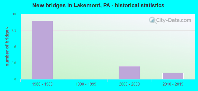
- New bridges - historical statistics
- 91980-1989
- 22000-2009
- 12010-2019


- Bridge Condition - Superstructure
- 33.3%Very good
- 16.7%Good
- 50.0%Satisfactory

- Bridge Condition - Substructure
- 33.3%Very good
- 50.0%Good
- 16.7%Satisfactory

- Bridge Condition - Channel
- 33.3%Very good
- 33.3%Good
- 33.3%Satisfactory
Find on map >> Show street view
Structure Number: 5597, Location: .5 MI.S.OF ALTOONA (Lat: 40.465394, Lng: -78.408033), Route carried "on" structure: Interstate 99, Year Built: 1984, Year Reconstructed: 2013, Status: Open, Structure Length: 4.36m (14.30ft), Average Daily Traffic: 26,782 (year 2021), Truck Traffic: 14%, Average Future Daily Traffic: 20,767 (year 2032), Design Load: HS 20, Features Intersected: SR 1001/BUSINESS US 220
Minimum Vertical Clearance: 30+ m (98+ ft), Kilometerpoint: 25.896, Lanes on structure: 3, Lanes under structure: 5, Base Highway Network: Yes, Owner: State Highway Agency, Approaching Roadway Width: 19.8m (65.0ft), Skew: 11 degrees, Material/Design: Steel, Design/Construction: Stringer/Multi-beam, Number Of Spans In Main Unit: 1, Length of Maximum Span: 42.1m (138.1ft), Curb or Sidewalk Widths: Left: 0.2m (0.7ft), Right: 0.2m (0.7ft), Curb-To-Curb Width: 18.9m (62.0ft), Out-to-Out Width: 20.0m (65.6ft)
Condition: Deck: Good, Superstructure: Satisfactory, Substructure: Good, Operating Rating: 88.0 metric tons, Method Used To Determine Operating Rating: Load Factor (LF), Inventory Rating: 52.6 metric tons, Method Used To Determine Inventory Rating: Load Factor (LF), Structural Evaluation: Equal to present minimum criteria, Deck Geometry: Superior to present desirable criteria, Underclear: High priority of corrective action, Approach Roadway Alignment: Equal to present desirable criteria, Length Of Structure Improvement: 5.20m (17.06ft), Designated Inspection Frequency: Every 24 months, Inspection Date: June 2021, Bridge Improvement Cost: $25,000, Roadway Improvement Cost: $73,000, Total Project Cost: $335,000, Deck Structure Type: Concrete Cast-file-Place, Wearing Surface/Protective System: Wearing Surface: Epoxy Overlay, Deck Protection: Epoxy Coated Reinforcing
Find on map >> Show street view
Structure Number: 5598, Location: .5 MI.S.OF ALTOONA (Lat: 40.465622, Lng: -78.407625), Route carried "on" structure: Interstate 99, Year Built: 1984, Year Reconstructed: 2013, Status: Open, Structure Length: 4.39m (14.40ft), Average Daily Traffic: 25,286 (year 2021), Truck Traffic: 15%, Average Future Daily Traffic: 20,116 (year 2032), Design Load: HS 20, Features Intersected: SR 1001/BUSINESS US 220
Minimum Vertical Clearance: 30+ m (98+ ft), Kilometerpoint: 25.939, Lanes on structure: 2, Lanes under structure: 5, Base Highway Network: Yes, Owner: State Highway Agency, Approaching Roadway Width: 11.9m (39.0ft), Skew: 11 degrees, Material/Design: Steel, Design/Construction: Stringer/Multi-beam, Number Of Spans In Main Unit: 1, Length of Maximum Span: 42.1m (138.1ft), Curb or Sidewalk Widths: Left: 0.2m (0.7ft), Right: 0.2m (0.7ft), Curb-To-Curb Width: 12.8m (42.0ft), Out-to-Out Width: 13.9m (45.6ft)
Condition: Deck: Good, Superstructure: Satisfactory, Substructure: Good, Inventory Rating: 53.5 metric tons, Method Used To Determine Inventory Rating: Load Factor (LF), Structural Evaluation: Equal to present minimum criteria, Deck Geometry: Equal to present desirable criteria, Underclear: High priority of corrective action, Approach Roadway Alignment: Equal to present desirable criteria, Length Of Structure Improvement: 5.20m (17.06ft), Designated Inspection Frequency: Every 24 months, Inspection Date: June 2021, Deck Structure Type: Concrete Cast-file-Place, Wearing Surface/Protective System: Wearing Surface: Epoxy Overlay, Deck Protection: Epoxy Coated Reinforcing
Find on map >> Show street view
Structure Number: 5689, Location: .25 MI.S.OF ALTOONA (Lat: 40.479558, Lng: -78.394417), Route carried "on" structure: State highway , Year Built: 1985, Year Reconstructed: 2013, Status: Open, Structure Length: 7.38m (24.21ft), Average Daily Traffic: 12,387 (year 2022), Truck Traffic: 3%, Average Future Daily Traffic: 17,989 (year 2032), Design Load: HS 25 or greater, Features Intersected: I-99 /US 220 & RAMPS, Facility Carried by Structure: SR 1009
Minimum Vertical Clearance: 30+ m (98+ ft), Kilometerpoint: 5.654, Lanes on structure: 2, Lanes under structure: 6, Owner: State Highway Agency, Approaching Roadway Width: 13.1m (43.0ft), Skew: 20 degrees, Material/Design: Prestressed concrete, Design/Construction: Box Beam or Girders - Multiple, Number Of Spans In Main Unit: 2, Length of Maximum Span: 38.1m (125.0ft), Curb or Sidewalk Widths: Left: 0.2m (0.7ft), Right: 0.2m (0.7ft), Curb-To-Curb Width: 12.8m (42.0ft), Out-to-Out Width: 26.7m (87.6ft)
Condition: Deck: Good, Superstructure: Good, Substructure: Satisfactory, Inventory Rating: 38.1 metric tons, Method Used To Determine Inventory Rating: Load Factor (LF), Structural Evaluation: Equal to present minimum criteria, Deck Geometry: Somewhat better than minimum adequacy, Underclear: High priority of corrective action, Approach Roadway Alignment: Equal to present desirable criteria, Length Of Structure Improvement: 8.30m (27.23ft), Designated Inspection Frequency: Every 24 months, Inspection Date: June 2021, Deck Structure Type: Concrete Cast-file-Place, Wearing Surface/Protective System: Wearing Surface: Epoxy Overlay, Deck Protection: Epoxy Coated Reinforcing
Find on map >> Show street view
Structure Number: 41853, Location: 500'WEST OF SR 36 (Lat: 40.457286, Lng: -78.397789), Route carried "on" structure: County highway , Year Built: 2001, Status: Open, Structure Length: 8.35m (27.40ft), Average Daily Traffic: 14,880 (year 2021), Truck Traffic: 8%, Average Future Daily Traffic: 18,600 (year 2041), Design Load: HL 93, Features Intersected: BRUSH RUN, Facility Carried by Structure: CNTY105,Conv Cen B
Minimum Vertical Clearance: 30+ m (98+ ft), Kilometerpoint: 0.000, Lanes on structure: 4, Owner: County Highway Agency, Approaching Roadway Width: 21.0m (68.9ft), Skew: 20 degrees, Material/Design: Prestressed concrete, Design/Construction: Stringer/Multi-beam, Number Of Spans In Main Unit: 2, Length of Maximum Span: 40.8m (133.9ft), Curb or Sidewalk Widths: Left: 0.2m (0.7ft), Right: 0.2m (0.7ft), Curb-To-Curb Width: 21.2m (69.6ft), Out-to-Out Width: 22.1m (72.5ft)
Condition: Deck: Good, Superstructure: Satisfactory, Substructure: Good, Channel: Good, Operating Rating: 58.1 metric tons, Method Used To Determine Operating Rating: Load and Resistance Factor (LRFR), Inventory Rating: 42.6 metric tons, Method Used To Determine Inventory Rating: Load and Resistance Factor (LRFR), Structural Evaluation: Equal to present minimum criteria, Deck Geometry: Superior to present desirable criteria, Waterway Adequacy: Superior to present desirable criteria, Approach Roadway Alignment: Equal to present desirable criteria, Length Of Structure Improvement: 9.30m (30.51ft), Designated Inspection Frequency: Every 24 months, Inspection Date: December 2019, Deck Structure Type: Concrete Cast-file-Place, Wearing Surface/Protective System: Wearing Surface: Monolithic Concrete, Deck Protection: Epoxy Coated Reinforcing
Find on map >> Show street view
Structure Number: 45616, Location: LAKEMONT (Lat: 40.466500, Lng: -78.395519), Route carried "on" structure: State highway , Year Built: 2009, Status: Open, Structure Length: 2.87m (9.42ft), Average Daily Traffic: 5,774 (year 2020), Truck Traffic: 2%, Average Future Daily Traffic: 6,860 (year 2032), Design Load: HL 93, Features Intersected: BRUSH RUN, Facility Carried by Structure: SR 1021
Minimum Vertical Clearance: 30+ m (98+ ft), Kilometerpoint: 0.000, Lanes on structure: 2, Owner: State Highway Agency, Approaching Roadway Width: 9.1m (29.9ft), Skew: 22 degrees, Material/Design: Prestressed concrete, Design/Construction: Box Beam or Girders - Single/Spread, Number Of Spans In Main Unit: 1, Length of Maximum Span: 27.4m (89.9ft), Curb or Sidewalk Widths: Left: 0.2m (0.7ft), Right: 1.5m (4.9ft), Curb-To-Curb Width: 10.5m (34.4ft), Out-to-Out Width: 28.8m (94.5ft)
Condition: Deck: Good, Superstructure: Very good, Substructure: Very good, Channel: Satisfactory, Operating Rating: 68.9 metric tons, Method Used To Determine Operating Rating: Load and Resistance Factor (LRFR), Inventory Rating: 36.3 metric tons, Method Used To Determine Inventory Rating: Load and Resistance Factor (LRFR), Structural Evaluation: Equal to present desirable criteria, Deck Geometry: Meets minimum limits, Waterway Adequacy: Superior to present desirable criteria, Approach Roadway Alignment: Equal to present desirable criteria, Designated Inspection Frequency: Every 24 months, Inspection Date: July 2020, Deck Structure Type: Concrete Cast-file-Place, Wearing Surface/Protective System: Wearing Surface: Monolithic Concrete, Deck Protection: Epoxy Coated Reinforcing
Find on map >> Show street view
Structure Number: 54752, Location: VILLAGE OF LAKEMONT (Lat: 40.464500, Lng: -78.395764), Route carried "on" structure: State highway 36, Year Built: 2017, Status: Open, Structure Length: 2.56m (8.40ft), Average Daily Traffic: 12,825 (year 2021), Truck Traffic: 6%, Average Future Daily Traffic: 15,747 (year 2032), Design Load: HL 93, Features Intersected: BRUSH RUN
Minimum Vertical Clearance: 30+ m (98+ ft), Kilometerpoint: 24.143, Lanes on structure: 2, Base Highway Network: Yes, Owner: State Highway Agency, Approaching Roadway Width: 27.4m (89.9ft), Skew: 6 degrees, Material/Design: Prestressed concrete, Design/Construction: Box Beam or Girders - Single/Spread, Number Of Spans In Main Unit: 1, Length of Maximum Span: 23.8m (78.1ft), Curb or Sidewalk Widths: Left: 0.2m (0.7ft), Right: 0.2m (0.7ft), Curb-To-Curb Width: 27.4m (89.9ft), Out-to-Out Width: 28.5m (93.5ft)
Condition: Deck: Good, Superstructure: Very good, Substructure: Very good, Channel: Very good, Operating Rating: 47.6 metric tons, Method Used To Determine Operating Rating: Assigned ratings based on Load and Resistance Factor Design (LRFD) reported by rating factor (RF) using HL93 loadings, Inventory Rating: 36.6 metric tons, Method Used To Determine Inventory Rating: Assigned ratings based on Load and Resistance Factor Design (LRFD) reported by rating factor (RF) using HL93 loadings, Structural Evaluation: Equal to present desirable criteria, Deck Geometry: Superior to present desirable criteria, Waterway Adequacy: Equal to present minimum criteria, Approach Roadway Alignment: Equal to present desirable criteria, Length Of Structure Improvement: 2.60m (8.53ft), Designated Inspection Frequency: Every 24 months, Inspection Date: August 2021, Deck Structure Type: Concrete Cast-file-Place, Wearing Surface/Protective System: Wearing Surface: Monolithic Concrete, Deck Protection: Epoxy Coated Reinforcing
Find on map >> Show street view
Structure Number: 5597, Location: .5 MI.S.OF ALTOONA (Lat: 40.465394, Lng: -78.408033), Route carried "under" structure: US 220B, Year Built: 1984, Structure Length: 0. m, Average Daily Traffic: 11,060 (year 2022), Truck Traffic: 2%, Features Intersected: SR 1001/BUSINESS US 220, Facility Carried by Structure: I-99 / US 220 NBL
Minimum Vertical Clearance: 4.76m (15.62ft), Kilometerpoint: 3.600, Lanes on structure: 3, Lanes under structure: 3, Material/Design: Steel, Design/Construction: Stringer/Multi-beam, Length of Maximum Span: 42.1m (138.1ft)
Find on map >> Show street view
Structure Number: 5597, Location: .5 MI.S.OF ALTOONA (Lat: 40.465394, Lng: -78.408033), Route carried "under" structure: US 220B, Year Built: 1984, Structure Length: 0. m, Average Daily Traffic: 11,432 (year 2022), Truck Traffic: 2%, Features Intersected: SR 1001/BUSINESS US 220, Facility Carried by Structure: I-99 / US 220 NBL
Minimum Vertical Clearance: 4.93m (16.17ft), Kilometerpoint: 3.610, Lanes on structure: 3, Lanes under structure: 2, Material/Design: Steel, Design/Construction: Stringer/Multi-beam, Length of Maximum Span: 42.1m (138.1ft)
Find on map >> Show street view
Structure Number: 5598, Location: .5 MI.S.OF ALTOONA (Lat: 40.465622, Lng: -78.407625), Route carried "under" structure: US 220B, Year Built: 1984, Structure Length: 0. m, Average Daily Traffic: 11,432 (year 2022), Truck Traffic: 2%, Features Intersected: SR 1001/BUSINESS US 220, Facility Carried by Structure: I-99 / US 220 SBL
Minimum Vertical Clearance: 4.72m (15.49ft), Kilometerpoint: 3.610, Lanes on structure: 2, Lanes under structure: 2, Material/Design: Steel, Design/Construction: Stringer/Multi-beam, Length of Maximum Span: 42.1m (138.1ft)
Find on map >> Show street view
Structure Number: 5598, Location: .5 MI.S.OF ALTOONA (Lat: 40.465622, Lng: -78.407625), Route carried "under" structure: US 220B, Year Built: 1984, Structure Length: 0. m, Average Daily Traffic: 11,060 (year 2022), Truck Traffic: 2%, Features Intersected: SR 1001/BUSINESS US 220, Facility Carried by Structure: I-99 / US 220 SBL
Minimum Vertical Clearance: 4.58m (15.03ft), Kilometerpoint: 3.600, Lanes on structure: 2, Lanes under structure: 3, Material/Design: Steel, Design/Construction: Stringer/Multi-beam, Length of Maximum Span: 42.1m (138.1ft)
Find on map >> Show street view
Structure Number: 5689, Location: .25 MI.S.OF ALTOONA (Lat: 40.479558, Lng: -78.394417), Route carried "under" structure: Interstate 99, Year Built: 1985, Structure Length: 0. m, Average Daily Traffic: 26,782 (year 2021), Truck Traffic: 14%, Features Intersected: I-99 /US 220 & RAMPS, Facility Carried by Structure: SR 1009
Minimum Vertical Clearance: 4.62m (15.16ft), Kilometerpoint: 27.512, Lanes on structure: 2, Lanes under structure: 3, Material/Design: Prestressed concrete, Design/Construction: Box Beam or Girders - Multiple, Length of Maximum Span: 38.1m (125.0ft)
Find on map >> Show street view
Structure Number: 5689, Location: .25 MI.S.OF ALTOONA (Lat: 40.479558, Lng: -78.394417), Route carried "under" structure: Interstate 99, Year Built: 1985, Structure Length: 0. m, Average Daily Traffic: 25,286 (year 2021), Truck Traffic: 15%, Features Intersected: I-99 /US 220 & RAMPS, Facility Carried by Structure: SR 1009
Minimum Vertical Clearance: 4.93m (16.17ft), Kilometerpoint: 27.507, Lanes on structure: 2, Lanes under structure: 3, Material/Design: Prestressed concrete, Design/Construction: Box Beam or Girders - Multiple, Length of Maximum Span: 38.1m (125.0ft)