Bridge Statistics for Lakeville, New York (NY)
Condition, Traffic, Stress, Structural Evaluation, Project Costs
- National Bridge Inventory (NBI) Statistics
- 14Number of bridges
- 279ft / 85.2mTotal length
- $45,552,000Total costs
- 100,563Total average daily traffic
- 3,447Total average daily truck traffic
- National Bridge Inventory (NBI) Registered Bridges for Lakeville
- No street view available for this location
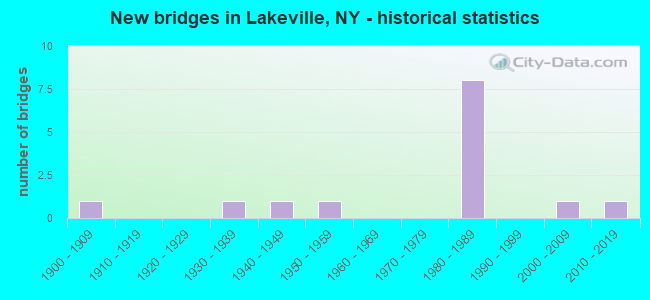
- New bridges - historical statistics
- 11900-1909
- 11930-1939
- 11940-1949
- 11950-1959
- 81980-1989
- 12000-2009
- 12010-2019


- Bridge Condition - Deck
- 11.1%Excellent
- 22.2%Very good
- 44.4%Good
- 11.1%Satisfactory
- 11.1%Poor

- Bridge Condition - Superstructure
- 22.2%Excellent
- 22.2%Very good
- 44.4%Good
- 11.1%Poor

- Bridge Condition - Substructure
- 11.1%Excellent
- 22.2%Good
- 66.7%Satisfactory

- Bridge Condition - Channel
- 16.7%Excellent
- 66.7%Very good
- 16.7%Satisfactory
Find on map >> Show street view
Structure Number: 101621, Location: .1 MI W JCT US20A & SH15 (Lat: 42.836292, Lng: -77.705939), Route carried "on" structure: US 20A, Year Built: 1957, Year Reconstructed: 2007, Status: Open, Structure Length: 1.74m (5.71ft), Average Daily Traffic: 6,050 (year 2020), Truck Traffic: 4%, Average Future Daily Traffic: 6,087 (year 2040), Design Load: HL 93, Features Intersected: CONESUS LK OUTLET
Minimum Vertical Clearance: 30+ m (98+ ft), Kilometerpoint: 24.248, Lanes on structure: 3, Base Highway Network: Yes, Owner: State Highway Agency, Approaching Roadway Width: 11.3m (37.1ft), Skew: 1 degrees, Material/Design: Prestressed concrete, Design/Construction: Box Beam or Girders - Multiple, Number Of Spans In Main Unit: 1, Length of Maximum Span: 16.2m (53.1ft), Curb or Sidewalk Widths: Left: 1.6m (5.2ft), Right: 1.6m (5.2ft), Curb-To-Curb Width: 14.4m (47.2ft), Out-to-Out Width: 18.2m (59.7ft)
Condition: Deck: Excellent, Superstructure: Excellent, Substructure: Good, Channel: Very good, Inventory Rating: 87.1 metric tons, Method Used To Determine Inventory Rating: Load Factor (LF), Structural Evaluation: Better than present minimum criteria, Deck Geometry: Somewhat better than minimum adequacy, Waterway Adequacy: Superior to present desirable criteria, Approach Roadway Alignment: Better than present minimum criteria, Length Of Structure Improvement: 1.73m (5.68ft), Designated Inspection Frequency: Every 24 months, Inspection Date: October 2021, Bridge Improvement Cost: $1,073,000, Roadway Improvement Cost: $629,000, Total Project Cost: $1,702,000 ( Estimate for 2021), Wearing Surface/Protective System: Wearing Surface: Bituminous, Membrane: Preformed Fabric
Find on map >> Show street view
Structure Number: 104349, Location: 0.1MI S JCT RTS 256 + 15 (Lat: 42.854011, Lng: -77.715633), Route carried "on" structure: State highway 256, Year Built: 1940, Status: Posted for load-capacity, Structure Length: 0.79m (2.59ft), Average Daily Traffic: 2,954 (year 2016), Truck Traffic: 6%, Average Future Daily Traffic: 2,972 (year 2040), Features Intersected: Conesus Creek
Minimum Vertical Clearance: 30+ m (98+ ft), Kilometerpoint: 33.725, Lanes on structure: 2, Base Highway Network: Yes, Owner: State Highway Agency, Approaching Roadway Width: 9.1m (29.9ft), Material/Design: Steel, Design/Construction: Stringer/Multi-beam, Number Of Spans In Main Unit: 1, Length of Maximum Span: 7.3m (24.0ft), Curb-To-Curb Width: 9.5m (31.2ft), Out-to-Out Width: 10.3m (33.8ft)
Condition: Deck: Poor, Superstructure: Poor, Substructure: Satisfactory, Channel: Satisfactory, Operating Rating: 20.7 metric tons, Method Used To Determine Operating Rating: Load and Resistance Factor Rating (LRFR) rating reported by rating factor(RF) method using HL-93 loadings, Inventory Rating: 15.9 metric tons, Method Used To Determine Inventory Rating: Load and Resistance Factor Rating (LRFR) rating reported by rating factor(RF) method using HL-93 loadings, Structural Evaluation: Meets minimum limits, Deck Geometry: Meets minimum limits, Waterway Adequacy: Equal to present minimum criteria, Approach Roadway Alignment: Equal to present minimum criteria, Length Of Structure Improvement: 0.79m (2.59ft), Designated Inspection Frequency: Every 24 months, Inspection Date: August 2021, Bridge Improvement Cost: $541,000, Roadway Improvement Cost: $317,000, Total Project Cost: $857,000 ( Estimate for 2021), Deck Structure Type: Concrete Cast-file-Place, Wearing Surface/Protective System: Wearing Surface: Bituminous
Find on map >> Show street view
Structure Number: 1071111, Location: 2.4 MI N JCT I390 & US20A (Lat: 42.862017, Lng: -77.728319), Route carried "on" structure: Interstate 390, Year Built: 1980, Status: Open, Structure Length: 26.30m (86.29ft), Average Daily Traffic: 7,105 (year 2013), Truck Traffic: 16%, Design Load: HS 20+Mod, Features Intersected: LIV AVON & LKVLLE, CONES
Minimum Vertical Clearance: 30+ m (98+ ft), Kilometerpoint: 47.321, Lanes on structure: 2, Base Highway Network: Yes, Owner: State Highway Agency, Approaching Roadway Width: 12.8m (42.0ft), Material/Design: Steel continuous, Design/Construction: Stringer/Multi-beam, Number Of Spans In Main Unit: 4, Length of Maximum Span: 73.1m (239.8ft), Curb-To-Curb Width: 12.8m (42.0ft), Out-to-Out Width: 13.7m (44.9ft)
Condition: Deck: Good, Superstructure: Good, Substructure: Satisfactory, Channel: Very good, Operating Rating: 61.7 metric tons, Method Used To Determine Operating Rating: Load Factor (LF), Inventory Rating: 36.3 metric tons, Method Used To Determine Inventory Rating: Load Factor (LF), Structural Evaluation: Equal to present minimum criteria, Deck Geometry: Equal to present desirable criteria, Underclear: Superior to present desirable criteria, Waterway Adequacy: Equal to present minimum criteria, Approach Roadway Alignment: Equal to present desirable criteria, Length Of Structure Improvement: 26.30m (86.29ft), Designated Inspection Frequency: Every 24 months, Inspection Date: September 2021, Bridge Improvement Cost: $8,181,000, Roadway Improvement Cost: $4,791,000, Total Project Cost: $12,972,000 ( Estimate for 2021), Deck Structure Type: Concrete Cast-file-Place, Wearing Surface/Protective System: Wearing Surface: Other, Deck Protection: Epoxy Coated Reinforcing
Find on map >> Show street view
Structure Number: 1071112, Location: 2.4 MI N JCT I390 & US20A (Lat: 42.862403, Lng: -77.727161), Route carried "on" structure: Interstate 390, Year Built: 1980, Status: Open, Structure Length: 28.16m (92.39ft), Average Daily Traffic: 5,825 (year 2018), Truck Traffic: 16%, Average Future Daily Traffic: 7,145 (year 2040), Design Load: HS 20+Mod, Features Intersected: LIV AVON & LKVLLE, CONES
Minimum Vertical Clearance: 30+ m (98+ ft), Kilometerpoint: 47.337, Lanes on structure: 2, Base Highway Network: Yes, Owner: State Highway Agency, Approaching Roadway Width: 12.8m (42.0ft), Material/Design: Steel continuous, Design/Construction: Stringer/Multi-beam, Number Of Spans In Main Unit: 4, Length of Maximum Span: 73.1m (239.8ft), Curb-To-Curb Width: 12.8m (42.0ft), Out-to-Out Width: 13.7m (44.9ft)
Condition: Deck: Good, Superstructure: Good, Substructure: Satisfactory, Channel: Very good, Operating Rating: 58.1 metric tons, Method Used To Determine Operating Rating: Load Factor (LF), Inventory Rating: 34.5 metric tons, Method Used To Determine Inventory Rating: Load Factor (LF), Structural Evaluation: Equal to present minimum criteria, Deck Geometry: Equal to present desirable criteria, Underclear: Superior to present desirable criteria, Waterway Adequacy: Superior to present desirable criteria, Approach Roadway Alignment: Equal to present desirable criteria, Length Of Structure Improvement: 28.16m (92.39ft), Designated Inspection Frequency: Every 24 months, Inspection Date: September 2021, Bridge Improvement Cost: $8,730,000, Roadway Improvement Cost: $5,112,000, Total Project Cost: $13,842,000 ( Estimate for 2021), Deck Structure Type: Concrete Cast-file-Place, Wearing Surface/Protective System: Wearing Surface: Other, Deck Protection: Epoxy Coated Reinforcing
Find on map >> Show street view
Structure Number: 107113, Location: 1.2 MI N JCT.RTS 390I&20A (Lat: 42.845553, Lng: -77.730247), Route carried "on" structure: Other road , Year Built: 1980, Status: Open, Structure Length: 8.75m (28.71ft), Average Daily Traffic: 1,844 (year 2019), Truck Traffic: 1%, Average Future Daily Traffic: 2,582 (year 2039), Design Load: HS 20, Features Intersected: 390I390I42021283 NB, RTE, Facility Carried by Structure: LIMA ROAD
Minimum Vertical Clearance: 30+ m (98+ ft), Kilometerpoint: 6.742, Lanes on structure: 2, Lanes under structure: 4, Owner: State Highway Agency, Approaching Roadway Width: 9.8m (32.2ft), Skew: 2 degrees, Material/Design: Steel continuous, Design/Construction: Stringer/Multi-beam, Number Of Spans In Main Unit: 2, Length of Maximum Span: 43.2m (141.7ft), Curb-To-Curb Width: 10.7m (35.1ft), Out-to-Out Width: 11.6m (38.1ft)
Condition: Deck: Satisfactory, Superstructure: Good, Substructure: Satisfactory, Operating Rating: 57.2 metric tons, Method Used To Determine Operating Rating: Load Factor (LF), Inventory Rating: 33.6 metric tons, Method Used To Determine Inventory Rating: Load Factor (LF), Structural Evaluation: Equal to present minimum criteria, Deck Geometry: Equal to present minimum criteria, Underclear: Equal to present minimum criteria, Approach Roadway Alignment: Equal to present desirable criteria, Length Of Structure Improvement: 8.74m (28.67ft), Designated Inspection Frequency: Every 24 months, Inspection Date: July 2021, Bridge Improvement Cost: $2,483,000, Roadway Improvement Cost: $1,454,000, Total Project Cost: $3,937,000 ( Estimate for 2021), Deck Structure Type: Concrete Cast-file-Place, Wearing Surface/Protective System: Wearing Surface: Integral Concrete, Deck Protection: Epoxy Coated Reinforcing
Find on map >> Show street view
Structure Number: 107114, Location: 2 MI N JCT I390 & S.H.20A (Lat: 42.856175, Lng: -77.729881), Route carried "on" structure: County highway , Year Built: 1980, Status: Open, Structure Length: 8.26m (27.10ft), Average Daily Traffic: 814 (year 2018), Truck Traffic: 7%, Average Future Daily Traffic: 1,140 (year 2038), Design Load: HS 20, Features Intersected: 390I390I42021290 NB, RTE, Facility Carried by Structure: Triphammer Rd CR5
Minimum Vertical Clearance: 30+ m (98+ ft), Kilometerpoint: 3.604, Lanes on structure: 2, Lanes under structure: 4, Owner: State Highway Agency, Approaching Roadway Width: 10.7m (35.1ft), Material/Design: Steel continuous, Design/Construction: Stringer/Multi-beam, Number Of Spans In Main Unit: 2, Length of Maximum Span: 40.5m (132.9ft), Curb-To-Curb Width: 10.7m (35.1ft), Out-to-Out Width: 11.6m (38.1ft)
Condition: Deck: Good, Superstructure: Good, Substructure: Satisfactory, Operating Rating: 59.9 metric tons, Method Used To Determine Operating Rating: Load Factor (LF), Inventory Rating: 36.3 metric tons, Method Used To Determine Inventory Rating: Load Factor (LF), Structural Evaluation: Equal to present minimum criteria, Deck Geometry: Equal to present minimum criteria, Underclear: Better than present minimum criteria, Approach Roadway Alignment: Equal to present desirable criteria, Length Of Structure Improvement: 8.26m (27.10ft), Designated Inspection Frequency: Every 24 months, Inspection Date: August 2021, Bridge Improvement Cost: $2,298,000, Roadway Improvement Cost: $1,346,000, Total Project Cost: $3,644,000 ( Estimate for 2021), Deck Structure Type: Concrete Cast-file-Place, Wearing Surface/Protective System: Wearing Surface: Integral Concrete, Deck Protection: Epoxy Coated Reinforcing
Find on map >> Show street view
Structure Number: 107115, Location: JCT I390 & S.H.15 (Lat: 42.868242, Lng: -77.713061), Route carried "on" structure: State highway 15, Year Built: 1980, Status: Open, Structure Length: 8.14m (26.71ft), Average Daily Traffic: 8,207 (year 2020), Truck Traffic: 8%, Average Future Daily Traffic: 8,257 (year 2040), Design Load: HS 20, Features Intersected: 390I390I42021303 WB, RTE
Minimum Vertical Clearance: 30+ m (98+ ft), Kilometerpoint: 38.182, Lanes on structure: 2, Lanes under structure: 4, Base Highway Network: Yes, Owner: State Highway Agency, Approaching Roadway Width: 19.5m (64.0ft), Skew: 22 degrees, Material/Design: Steel continuous, Design/Construction: Stringer/Multi-beam, Number Of Spans In Main Unit: 2, Length of Maximum Span: 39.9m (130.9ft), Curb-To-Curb Width: 19.5m (64.0ft), Out-to-Out Width: 20.4m (66.9ft)
Condition: Deck: Good, Superstructure: Very good, Substructure: Good, Operating Rating: 64.4 metric tons, Method Used To Determine Operating Rating: Load Factor (LF), Inventory Rating: 38.1 metric tons, Method Used To Determine Inventory Rating: Load Factor (LF), Structural Evaluation: Better than present minimum criteria, Deck Geometry: Superior to present desirable criteria, Underclear: Equal to present minimum criteria, Approach Roadway Alignment: Equal to present desirable criteria, Length Of Structure Improvement: 8.13m (26.67ft), Designated Inspection Frequency: Every 24 months, Inspection Date: May 2021, Bridge Improvement Cost: $4,034,000, Roadway Improvement Cost: $2,362,000, Total Project Cost: $6,396,000 ( Estimate for 2021), Deck Structure Type: Concrete Cast-file-Place, Wearing Surface/Protective System: Wearing Surface: Integral Concrete, Deck Protection: Epoxy Coated Reinforcing
Find on map >> Show street view
Structure Number: 331618, Location: 1.9 MI NW OF LAKEVILLE (Lat: 42.859639, Lng: -77.738472), Route carried "on" structure: Other road , Year Built: 2015, Status: Open, Structure Length: 1.77m (5.81ft), Average Daily Traffic: 652 (year 2017), Truck Traffic: 11%, Average Future Daily Traffic: 913 (year 2037), Design Load: HL 93, Features Intersected: CONESUS OUTLET, Facility Carried by Structure: POLE BRIDGE RD
Minimum Vertical Clearance: 30+ m (98+ ft), Kilometerpoint: 5.696, Lanes on structure: 2, Owner: County Highway Agency, Approaching Roadway Width: 6.7m (22.0ft), Material/Design: Wood or Timber, Design/Construction: Stringer/Multi-beam, Number Of Spans In Main Unit: 1, Length of Maximum Span: 16.5m (54.1ft), Curb-To-Curb Width: 7.9m (25.9ft), Out-to-Out Width: 8.5m (27.9ft)
Condition: Deck: Very good, Superstructure: Excellent, Substructure: Excellent, Channel: Excellent, Operating Rating: 53.5 metric tons, Method Used To Determine Operating Rating: Allowable Stress (AS), Inventory Rating: 36.3 metric tons, Method Used To Determine Inventory Rating: Allowable Stress (AS), Structural Evaluation: Superior to present desirable criteria, Deck Geometry: Somewhat better than minimum adequacy, Waterway Adequacy: Better than present minimum criteria, Approach Roadway Alignment: Somewhat better than minimum adequacy, Length Of Structure Improvement: 1.76m (5.77ft), Designated Inspection Frequency: Every 24 months, Inspection Date: September 2021, Bridge Improvement Cost: $664,000, Roadway Improvement Cost: $389,000, Total Project Cost: $1,053,000 ( Estimate for 2021), Deck Structure Type: Wood or Timber, Wearing Surface/Protective System: Wearing Surface: Bituminous
Find on map >> Show street view
Structure Number: 331619, Location: 2 MI NW OF LAKEVILLE (Lat: 42.855922, Lng: -77.717267), Route carried "on" structure: County highway , Year Built: 2001, Status: Open, Structure Length: 1.25m (4.10ft), Average Daily Traffic: 886 (year 2016), Truck Traffic: 10%, Average Future Daily Traffic: 1,240 (year 2036), Design Load: HS 25 or greater, Features Intersected: CONESUS OUTLET, Facility Carried by Structure: TRIPHAMMER ROAD
Minimum Vertical Clearance: 30+ m (98+ ft), Kilometerpoint: 1.609, Lanes on structure: 2, Owner: County Highway Agency, Approaching Roadway Width: 8.8m (28.9ft), Design/Construction: Slab, Number Of Spans In Main Unit: 1, Length of Maximum Span: 12.1m (39.7ft), Curb-To-Curb Width: 9.0m (29.5ft), Out-to-Out Width: 10.0m (32.8ft)
Condition: Deck: Very good, Superstructure: Very good, Substructure: Satisfactory, Channel: Very good, Operating Rating: 81.3 metric tons, Method Used To Determine Operating Rating: Field evaluation and documented engineering judgment, Inventory Rating: 40.8 metric tons, Method Used To Determine Inventory Rating: Field evaluation and documented engineering judgment, Structural Evaluation: Equal to present minimum criteria, Deck Geometry: Somewhat better than minimum adequacy, Waterway Adequacy: Better than present minimum criteria, Approach Roadway Alignment: Equal to present desirable criteria, Length Of Structure Improvement: 1.24m (4.07ft), Designated Inspection Frequency: Every 24 months, Inspection Date: September 2021, Bridge Improvement Cost: $725,000, Roadway Improvement Cost: $425,000, Total Project Cost: $1,149,000 ( Estimate for 2021), Wearing Surface/Protective System: Wearing Surface: Bituminous, Membrane: Other
Find on map >> Show street view
Structure Number: 107113, Location: 1.2 MI N JCT.RTS 390I&20A (Lat: 42.845553, Lng: -77.730247), Route carried "under" structure: Interstate 390, Year Built: 1980, Structure Length: 0. m, Average Daily Traffic: 17,188 (year 2002), Features Intersected: 390I390I42021283 NB, RTE, Facility Carried by Structure: LIMA ROAD
Minimum Vertical Clearance: 5.13m (16.83ft), Kilometerpoint: 45.663, Lanes on structure: 2, Lanes under structure: 2, Material/Design: Steel continuous, Design/Construction: Stringer/Multi-beam, Length of Maximum Span: 43.2m (141.7ft)
Find on map >> Show street view
Structure Number: 107114, Location: 2 MI N JCT I390 & S.H.20A (Lat: 42.856175, Lng: -77.729881), Route carried "under" structure: Interstate 390, Year Built: 1980, Structure Length: 0. m, Average Daily Traffic: 17,188 (year 2002), Features Intersected: 390I390I42021290 NB, RTE, Facility Carried by Structure: Triphammer Rd CR5
Minimum Vertical Clearance: 5.28m (17.32ft), Kilometerpoint: 46.822, Lanes on structure: 2, Lanes under structure: 2, Material/Design: Steel continuous, Design/Construction: Stringer/Multi-beam, Length of Maximum Span: 40.5m (132.9ft)
Find on map >> Show street view
Structure Number: 107115, Location: JCT I390 & S.H.15 (Lat: 42.868242, Lng: -77.713061), Route carried "under" structure: Interstate 390, Year Built: 1980, Structure Length: 0. m, Average Daily Traffic: 20,826 (year 2002), Features Intersected: 390I390I42021303 WB, RTE, Facility Carried by Structure: RTE 15
Minimum Vertical Clearance: 5.13m (16.83ft), Kilometerpoint: 48.946, Lanes on structure: 2, Lanes under structure: 2, Material/Design: Steel continuous, Design/Construction: Stringer/Multi-beam, Length of Maximum Span: 39.9m (130.9ft)
Find on map >> Show street view
Structure Number: 701149, Location: 3.2MI S JCT RTS 15 + 5+20 (Lat: 42.863739, Lng: -77.713750), Route carried "under" structure: US 15, Year Built: 1931, Structure Length: 0. m, Average Daily Traffic: 10,372 (year 2000), Features Intersected: RTE 15, Facility Carried by Structure: LIV AVON & LKVLLE
Minimum Vertical Clearance: 4.47m (14.67ft), Kilometerpoint: 37.860, Lanes under structure: 2, Material/Design: Steel, Design/Construction: Girder and Floorbeam System, Length of Maximum Span: 15.5m (50.9ft)
Find on map >> Show street view
Structure Number: 721085, Location: 2 MI NW OF LAKEVILLE (Lat: 42.859978, Lng: -77.738567), Route carried "under" structure: Other road , Year Built: 1900, Structure Length: 0. m, Average Daily Traffic: 652 (year 2017), Truck Traffic: 11%, Features Intersected: POLE BRIDGE ROAD, Facility Carried by Structure: LIV AVON & LKVIL
Minimum Vertical Clearance: 3.61m (11.84ft), Kilometerpoint: 3.926, Lanes under structure: 2, Material/Design: Steel, Design/Construction: Stringer/Multi-beam, Length of Maximum Span: 10.0m (32.8ft)