Bridge Statistics for Lakewood, Washington (WA)
Condition, Traffic, Stress, Structural Evaluation, Project Costs
- National Bridge Inventory (NBI) Statistics
- 39Number of bridges
- 446ft / 136mTotal length
- $109,519,000Total costs
- 2,107,363Total average daily traffic
- 180,463Total average daily truck traffic
- National Bridge Inventory (NBI) Registered Bridges for Lakewood
- No street view available for this location
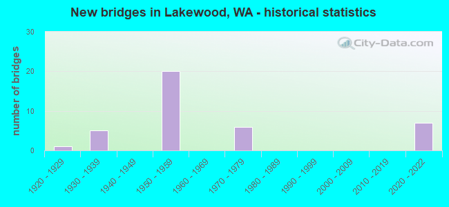
- New bridges - historical statistics
- 11920-1929
- 51930-1939
- 201950-1959
- 61970-1979
- 72020-2022
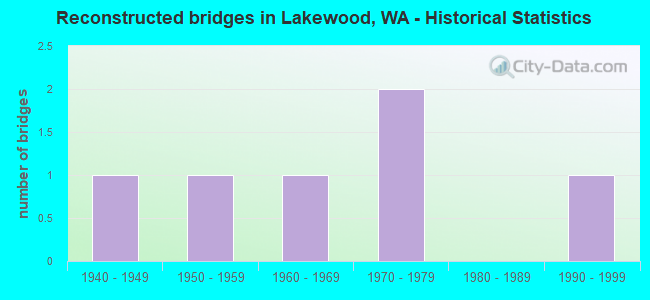
- Reconstructed bridges - Historical Statistics
- 11940-1949
- 11950-1959
- 11960-1969
- 21970-1979
- 01980-1989
- 11990-1999
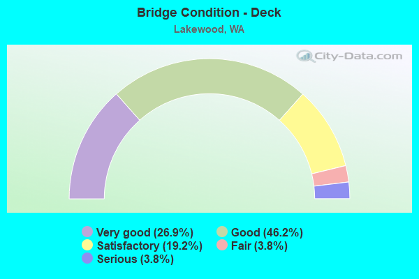
- Bridge Condition - Deck
- 26.9%Very good
- 46.2%Good
- 19.2%Satisfactory
- 3.8%Fair
- 3.8%Serious
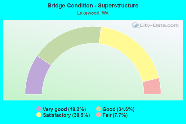
- Bridge Condition - Superstructure
- 19.2%Very good
- 34.6%Good
- 38.5%Satisfactory
- 7.7%Fair
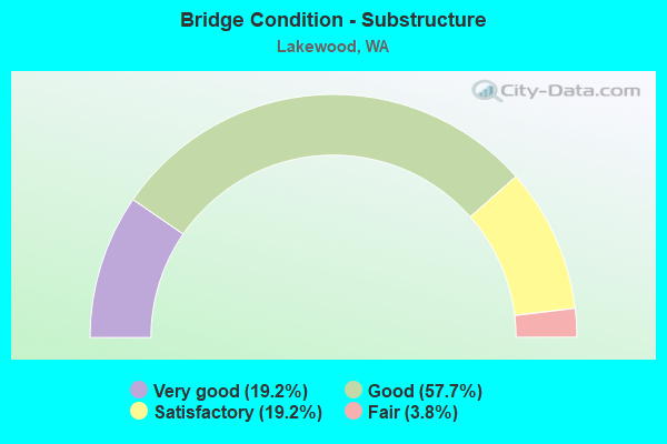
- Bridge Condition - Substructure
- 19.2%Very good
- 57.7%Good
- 19.2%Satisfactory
- 3.8%Fair
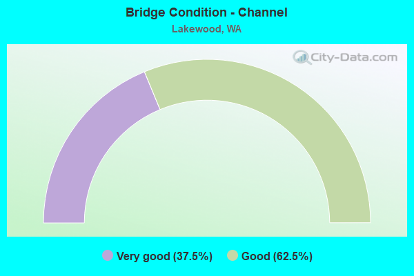
- Bridge Condition - Channel
- 37.5%Very good
- 62.5%Good
Find on map >> Show street view
Structure Number: PB, Location: 0.6 E JCT I-5 (Lat: 47.159967, Lng: -122.467847), Route carried "on" structure: County highway , Year Built: 1975, Status: Open, Structure Length: 4.21m (13.81ft), Average Daily Traffic: 13,792 (year 2020), Truck Traffic: 8%, Average Future Daily Traffic: 23,498 (year 2040), Design Load: HS 20+Mod, Features Intersected: SR 512, Facility Carried by Structure: STEELE ST
Minimum Vertical Clearance: 30+ m (98+ ft), Kilometerpoint: 0.097, Lanes on structure: 2, Lanes under structure: 8, Base Highway Network: Yes, Owner: State Highway Agency, Approaching Roadway Width: 8.5m (27.9ft), Skew: 1 degrees, Material/Design: Concrete continuous, Design/Construction: Slab, Number Of Spans In Main Unit: 2, Length of Maximum Span: 20.7m (67.9ft), Curb or Sidewalk Widths: Left: 1.2m (3.9ft), Right: 1.0m (3.3ft), Curb-To-Curb Width: 7.9m (25.9ft), Out-to-Out Width: 10.3m (33.8ft)
Condition: Deck: Good, Superstructure: Good, Substructure: Good, Operating Rating: 87.1 metric tons, Method Used To Determine Operating Rating: Load Factor (LF), Inventory Rating: 54.4 metric tons, Method Used To Determine Inventory Rating: Load Factor (LF), Structural Evaluation: Better than present minimum criteria, Deck Geometry: High priority of replacement, Underclear: High priority of corrective action, Approach Roadway Alignment: Equal to present minimum criteria, Length Of Structure Improvement: 4.21m (13.81ft), Designated Inspection Frequency: Every 48 months, Inspection Date: July 2021, Bridge Improvement Cost: $828,000, Roadway Improvement Cost: $166,000, Total Project Cost: $1,656,000 ( Estimate for 2014), Deck Structure Type: Concrete Cast-file-Place, Wearing Surface/Protective System: Wearing Surface: Latex Concrete
Find on map >> Show street view
Structure Number: 5523A, Location: 10.4 N THURSTON C0 (Lat: 47.141639, Lng: -122.515194), Route carried "on" structure: City street , Year Built: 1957, Status: Open, Structure Length: 4.24m (13.91ft), Average Daily Traffic: 2,358 (year 2002), Truck Traffic: 1%, Average Future Daily Traffic: 4,282 (year 2036), Design Load: HS 20, Features Intersected: I-5, Facility Carried by Structure: NEW YORK AVE
Minimum Vertical Clearance: 30+ m (98+ ft), Kilometerpoint: 0.113, Lanes on structure: 2, Lanes under structure: 8, Owner: State Highway Agency, Approaching Roadway Width: 9.1m (29.9ft), Material/Design: Concrete continuous, Design/Construction: Slab, Number Of Spans In Main Unit: 2, Length of Maximum Span: 20.7m (67.9ft), Curb or Sidewalk Widths: Left: 0.8m (2.6ft), Right: 0.8m (2.6ft), Curb-To-Curb Width: 7.9m (25.9ft), Out-to-Out Width: 10.1m (33.1ft)
Condition: Deck: Satisfactory, Superstructure: Fair, Substructure: Good, Operating Rating: 82.5 metric tons, Method Used To Determine Operating Rating: Load Factor (LF), Inventory Rating: 49.0 metric tons, Method Used To Determine Inventory Rating: Load Factor (LF), Structural Evaluation: Somewhat better than minimum adequacy, Deck Geometry: High priority of corrective action, Underclear: High priority of corrective action, Approach Roadway Alignment: Equal to present minimum criteria, Length Of Structure Improvement: 4.24m (13.91ft), Designated Inspection Frequency: Every 24 months, Inspection Date: September 2021, Bridge Improvement Cost: $890,000, Roadway Improvement Cost: $178,000, Total Project Cost: $1,779,000 ( Estimate for 2014), Deck Structure Type: Concrete Cast-file-Place, Wearing Surface/Protective System: Wearing Surface: Monolithic Concrete
Find on map >> Show street view
Structure Number: 5523B, Location: 10.9 N THURSTON CO (Lat: 47.145000, Lng: -122.508222), Route carried "on" structure: Interstate 5, Year Built: 1957, Year Reconstructed: 1974, Status: Open, Structure Length: 2.10m (6.89ft), Average Daily Traffic: 134,047 (year 2019), Truck Traffic: 9%, Average Future Daily Traffic: 194,100 (year 2039), Design Load: HS 20, Features Intersected: CLOVER CREEK
Minimum Vertical Clearance: 30+ m (98+ ft), Kilometerpoint: 202.198, Lanes on structure: 10, Base Highway Network: Yes, Owner: State Highway Agency, Approaching Roadway Width: 48.8m (160.1ft), Skew: 33 degrees, Material/Design: Concrete continuous, Design/Construction: Slab, Number Of Spans In Main Unit: 3, Length of Maximum Span: 8.2m (26.9ft), Curb-To-Curb Width: 48.8m (160.1ft), Out-to-Out Width: 50.9m (167.0ft)
Condition: Deck: Satisfactory, Superstructure: Good, Substructure: Satisfactory, Channel: Good, Operating Rating: 55.3 metric tons, Method Used To Determine Operating Rating: Load Factor (LF), Inventory Rating: 32.7 metric tons, Method Used To Determine Inventory Rating: Load Factor (LF), Structural Evaluation: Equal to present minimum criteria, Deck Geometry: Superior to present desirable criteria, Waterway Adequacy: Equal to present desirable criteria, Approach Roadway Alignment: Equal to present desirable criteria, Length Of Structure Improvement: 2.10m (6.89ft), Designated Inspection Frequency: Every 24 months, Inspection Date: June 2021, Bridge Improvement Cost: $2,236,000, Roadway Improvement Cost: $447,000, Total Project Cost: $4,471,000 ( Estimate for 2014), Deck Structure Type: Concrete Cast-file-Place, Wearing Surface/Protective System: Wearing Surface: Latex Concrete
Find on map >> Show street view
Structure Number: 5523C, Location: 11.3 N THURSTON CO (Lat: 47.150581, Lng: -122.499178), Route carried "on" structure: City street , Year Built: 1957, Status: Open, Structure Length: 9.66m (31.69ft), Average Daily Traffic: 3,217 (year 2002), Truck Traffic: 1%, Average Future Daily Traffic: 4,420 (year 2036), Design Load: HS 20, Features Intersected: I-5, Facility Carried by Structure: 47TH AVE SW
Minimum Vertical Clearance: 30+ m (98+ ft), Kilometerpoint: 0.177, Lanes on structure: 2, Lanes under structure: 8, Owner: State Highway Agency, Approaching Roadway Width: 7.9m (25.9ft), Material/Design: Concrete continuous, Design/Construction: Box Beam or Girders - Multiple, Number Of Spans In Main Unit: 4, Length of Maximum Span: 27.7m (90.9ft), Curb or Sidewalk Widths: Left: 0.6m (2.0ft), Right: 0.6m (2.0ft), Curb-To-Curb Width: 7.9m (25.9ft), Out-to-Out Width: 10.4m (34.1ft)
Condition: Deck: Good, Superstructure: Fair, Substructure: Good, Operating Rating: 57.0 metric tons, Method Used To Determine Operating Rating: Load and Resistance Factor Rating (LRFR) rating reported by rating factor(RF) method using HL-93 loadings, Inventory Rating: 44.1 metric tons, Method Used To Determine Inventory Rating: Load and Resistance Factor Rating (LRFR) rating reported by rating factor(RF) method using HL-93 loadings, Structural Evaluation: Somewhat better than minimum adequacy, Deck Geometry: High priority of corrective action, Underclear: High priority of corrective action, Approach Roadway Alignment: Equal to present desirable criteria, Length Of Structure Improvement: 9.66m (31.69ft), Designated Inspection Frequency: Every 24 months, Inspection Date: November 2021, Bridge Improvement Cost: $1,775,000, Roadway Improvement Cost: $355,000, Total Project Cost: $3,550,000 ( Estimate for 2014), Deck Structure Type: Concrete Cast-file-Place, Wearing Surface/Protective System: Wearing Surface: Monolithic Concrete
Find on map >> Show street view
Structure Number: 5582A, Location: 11.1 N THURSTON CO (Lat: 47.147558, Lng: -122.504419), Route carried "on" structure: City street , Year Built: 1958, Status: Open, Structure Length: 8.96m (29.40ft), Average Daily Traffic: 13,128 (year 2016), Truck Traffic: 5%, Average Future Daily Traffic: 21,372 (year 2038), Design Load: HS 20, Features Intersected: I-5, Facility Carried by Structure: BRIDGEPORT WAY
Minimum Vertical Clearance: 30+ m (98+ ft), Kilometerpoint: 0.080, Lanes on structure: 4, Lanes under structure: 8, Base Highway Network: Yes, Owner: State Highway Agency, Approaching Roadway Width: 16.2m (53.1ft), Skew: 3 degrees, Material/Design: Concrete continuous, Design/Construction: Box Beam or Girders - Multiple, Number Of Spans In Main Unit: 4, Length of Maximum Span: 26.8m (87.9ft), Curb or Sidewalk Widths: Left: 1.5m (4.9ft), Right: 0.8m (2.6ft), Curb-To-Curb Width: 16.2m (53.1ft), Out-to-Out Width: 19.2m (63.0ft)
Condition: Deck: Good, Superstructure: Satisfactory, Substructure: Good, Operating Rating: 79.8 metric tons, Method Used To Determine Operating Rating: Load Factor (LF), Inventory Rating: 47.2 metric tons, Method Used To Determine Inventory Rating: Load Factor (LF), Structural Evaluation: Equal to present minimum criteria, Deck Geometry: Meets minimum limits, Underclear: High priority of corrective action, Approach Roadway Alignment: Equal to present desirable criteria, Length Of Structure Improvement: 8.96m (29.40ft), Designated Inspection Frequency: Every 24 months, Inspection Date: November 2021, Bridge Improvement Cost: $3,234,000, Roadway Improvement Cost: $647,000, Total Project Cost: $6,468,000 ( Estimate for 2014), Deck Structure Type: Concrete Cast-file-Place, Wearing Surface/Protective System: Wearing Surface: Latex Concrete
Find on map >> Show street view
Structure Number: 5651A, Location: 12.1 N THURSTON CO (Lat: 47.159764, Lng: -122.483589), Route carried "on" structure: City street , Year Built: 1958, Status: Open, Structure Length: 8.63m (28.31ft), Average Daily Traffic: 17,105 (year 2021), Truck Traffic: 6%, Average Future Daily Traffic: 19,158 (year 2041), Design Load: HS 20, Features Intersected: I-5, Facility Carried by Structure: S TACOMA WAY
Minimum Vertical Clearance: 30+ m (98+ ft), Kilometerpoint: 14.886, Lanes on structure: 2, Lanes under structure: 9, Base Highway Network: Yes, Owner: State Highway Agency, Approaching Roadway Width: 12.2m (40.0ft), Material/Design: Concrete continuous, Design/Construction: Box Beam or Girders - Multiple, Number Of Spans In Main Unit: 2, Length of Maximum Span: 41.5m (136.2ft), Curb or Sidewalk Widths: Left: 1.4m (4.6ft), Right: 1.4m (4.6ft), Curb-To-Curb Width: 8.5m (27.9ft), Out-to-Out Width: 12.2m (40.0ft)
Condition: Deck: Good, Superstructure: Satisfactory, Substructure: Good, Operating Rating: 29.5 metric tons, Method Used To Determine Operating Rating: Load and Resistance Factor Rating (LRFR) rating reported by rating factor(RF) method using HL-93 loadings, Inventory Rating: 23.0 metric tons, Method Used To Determine Inventory Rating: Load and Resistance Factor Rating (LRFR) rating reported by rating factor(RF) method using HL-93 loadings, Structural Evaluation: Somewhat better than minimum adequacy, Deck Geometry: Meets minimum limits, Underclear: High priority of corrective action, Approach Roadway Alignment: Equal to present desirable criteria, Length Of Structure Improvement: 8.63m (28.31ft), Designated Inspection Frequency: Every 24 months, Inspection Date: November 2020, Bridge Improvement Cost: $2,377,000, Roadway Improvement Cost: $475,000, Total Project Cost: $4,754,000 ( Estimate for 2014), Deck Structure Type: Concrete Cast-file-Place, Wearing Surface/Protective System: Wearing Surface: Latex Concrete
Find on map >> Show street view
Structure Number: 5655A, Location: 12.7 N THURSTON CO (Lat: 47.163331, Lng: -122.480278), Route carried "on" structure: State highway 512, Year Built: 1958, Status: Open, Structure Length: 6.43m (21.10ft), Average Daily Traffic: 78,216 (year 2019), Truck Traffic: 8%, Average Future Daily Traffic: 113,256 (year 2039), Design Load: HS 20, Features Intersected: I-5
Minimum Vertical Clearance: 30+ m (98+ ft), Kilometerpoint: 0.001, Lanes on structure: 6, Lanes under structure: 12, Base Highway Network: Yes, Owner: State Highway Agency, Approaching Roadway Width: 23.8m (78.1ft), Skew: 31 degrees, Material/Design: Concrete continuous, Design/Construction: Slab, Number Of Spans In Main Unit: 4, Length of Maximum Span: 18.0m (59.1ft), Curb-To-Curb Width: 23.8m (78.1ft), Out-to-Out Width: 25.6m (84.0ft)
Condition: Deck: Fair, Superstructure: Satisfactory, Substructure: Satisfactory, Operating Rating: 51.7 metric tons, Method Used To Determine Operating Rating: Load Factor (LF), Inventory Rating: 30.8 metric tons, Method Used To Determine Inventory Rating: Load Factor (LF), Structural Evaluation: Equal to present minimum criteria, Deck Geometry: Meets minimum limits, Underclear: High priority of corrective action, Approach Roadway Alignment: Equal to present desirable criteria, Length Of Structure Improvement: 6.43m (21.10ft), Designated Inspection Frequency: Every 24 months, Inspection Date: November 2021, Bridge Improvement Cost: $3,376,000, Roadway Improvement Cost: $675,000, Total Project Cost: $6,752,000 ( Estimate for 2014), Deck Structure Type: Concrete Cast-file-Place, Wearing Surface/Protective System: Wearing Surface: Latex Concrete
Find on map >> Show street view
Structure Number: 5667A, Location: 0.6 N JCT SR 512 (Lat: 47.170111, Lng: -122.472556), Route carried "on" structure: Interstate 5, Year Built: 1958, Status: Open, Structure Length: 2.65m (8.69ft), Average Daily Traffic: 89,243 (year 2019), Truck Traffic: 11%, Average Future Daily Traffic: 129,223 (year 2039), Design Load: HS 20, Features Intersected: S96TH ST
Minimum Vertical Clearance: 30+ m (98+ ft), Kilometerpoint: 206.093, Lanes on structure: 4, Lanes under structure: 4, Base Highway Network: Yes, Owner: State Highway Agency, Approaching Roadway Width: 20.1m (65.9ft), Skew: 3 degrees, Material/Design: Concrete, Design/Construction: Box Beam or Girders - Multiple, Number Of Spans In Main Unit: 1, Length of Maximum Span: 25.3m (83.0ft), Curb-To-Curb Width: 19.2m (63.0ft), Out-to-Out Width: 20.1m (65.9ft)
Condition: Deck: Good, Superstructure: Satisfactory, Substructure: Good, Operating Rating: 89.8 metric tons, Method Used To Determine Operating Rating: Load Factor (LF), Inventory Rating: 89.8 metric tons, Method Used To Determine Inventory Rating: Load Factor (LF), Structural Evaluation: Equal to present minimum criteria, Deck Geometry: Somewhat better than minimum adequacy, Underclear: Meets minimum limits, Approach Roadway Alignment: Equal to present desirable criteria, Length Of Structure Improvement: 2.65m (8.69ft), Designated Inspection Frequency: Every 24 months, Inspection Date: April 2021, Bridge Improvement Cost: $1,183,000, Roadway Improvement Cost: $237,000, Total Project Cost: $2,366,000 ( Estimate for 2014), Deck Structure Type: Concrete Cast-file-Place, Wearing Surface/Protective System: Wearing Surface: Latex Concrete
Find on map >> Show street view
Structure Number: 5667B, Location: 0.6 N JCT SR 512 (Lat: 47.170111, Lng: -122.472889), Route carried "on" structure: Interstate 5, Year Built: 1958, Status: Open, Structure Length: 2.62m (8.60ft), Average Daily Traffic: 89,243 (year 2019), Truck Traffic: 11%, Average Future Daily Traffic: 129,223 (year 2039), Design Load: HS 20, Features Intersected: S 96TH ST
Minimum Vertical Clearance: 30+ m (98+ ft), Kilometerpoint: 206.093, Lanes on structure: 4, Lanes under structure: 4, Base Highway Network: Yes, Owner: State Highway Agency, Approaching Roadway Width: 20.1m (65.9ft), Skew: 2 degrees, Material/Design: Concrete, Design/Construction: Box Beam or Girders - Multiple, Number Of Spans In Main Unit: 1, Length of Maximum Span: 25.3m (83.0ft), Curb-To-Curb Width: 20.1m (65.9ft), Out-to-Out Width: 21.2m (69.6ft)
Condition: Deck: Good, Superstructure: Good, Substructure: Good, Operating Rating: 89.8 metric tons, Method Used To Determine Operating Rating: Load Factor (LF), Inventory Rating: 89.8 metric tons, Method Used To Determine Inventory Rating: Load Factor (LF), Structural Evaluation: Better than present minimum criteria, Deck Geometry: Equal to present minimum criteria, Underclear: Somewhat better than minimum adequacy, Approach Roadway Alignment: Equal to present desirable criteria, Length Of Structure Improvement: 2.62m (8.60ft), Designated Inspection Frequency: Every 24 months, Inspection Date: April 2021, Bridge Improvement Cost: $1,170,000, Roadway Improvement Cost: $234,000, Total Project Cost: $2,339,000 ( Estimate for 2014), Deck Structure Type: Concrete Cast-file-Place, Wearing Surface/Protective System: Wearing Surface: Latex Concrete
Find on map >> Show street view
Structure Number: 5943A, Location: 9.7 N THURSTON CO (Lat: 47.137111, Lng: -122.525611), Route carried "on" structure: City street , Year Built: 1959, Status: Open, Structure Length: 4.42m (14.50ft), Average Daily Traffic: 14,297 (year 2010), Truck Traffic: 5%, Average Future Daily Traffic: 24,333 (year 2036), Design Load: HS 20, Features Intersected: I-5, Facility Carried by Structure: GRAVELLY LAKE DRIV
Minimum Vertical Clearance: 30+ m (98+ ft), Kilometerpoint: 0.032, Lanes on structure: 4, Lanes under structure: 8, Base Highway Network: Yes, Owner: State Highway Agency, Approaching Roadway Width: 17.1m (56.1ft), Material/Design: Concrete continuous, Design/Construction: Slab, Number Of Spans In Main Unit: 2, Length of Maximum Span: 21.6m (70.9ft), Curb or Sidewalk Widths: Left: 1.2m (3.9ft), Right: 1.2m (3.9ft), Curb-To-Curb Width: 17.1m (56.1ft), Out-to-Out Width: 20.8m (68.2ft)
Condition: Deck: Satisfactory, Superstructure: Satisfactory, Substructure: Satisfactory, Operating Rating: 71.7 metric tons, Method Used To Determine Operating Rating: Load Factor (LF), Inventory Rating: 41.7 metric tons, Method Used To Determine Inventory Rating: Load Factor (LF), Structural Evaluation: Equal to present minimum criteria, Deck Geometry: Somewhat better than minimum adequacy, Underclear: Meets minimum limits, Approach Roadway Alignment: Equal to present desirable criteria, Length Of Structure Improvement: 4.42m (14.50ft), Designated Inspection Frequency: Every 24 months, Inspection Date: November 2021, Bridge Improvement Cost: $1,682,000, Roadway Improvement Cost: $336,000, Total Project Cost: $3,364,000 ( Estimate for 2014), Deck Structure Type: Concrete Cast-file-Place, Wearing Surface/Protective System: Wearing Surface: Monolithic Concrete
Find on map >> Show street view
Structure Number: 5943B, Location: 9.7 N THURSTON CO (Lat: 47.137500, Lng: -122.525889), Route carried "on" structure: City street 5, Year Built: 1959, Status: Open, Structure Length: 0.82m (2.69ft), Average Daily Traffic: 27,805 (year 2002), Truck Traffic: 5%, Average Future Daily Traffic: 53,330 (year 2036), Design Load: HS 20, Features Intersected: BNRR (NP), Facility Carried by Structure: GRAVELLY LAKE DR
Minimum Vertical Clearance: 30+ m (98+ ft), Kilometerpoint: 0.113, Lanes on structure: 4, Base Highway Network: Yes, Owner: State Highway Agency, Approaching Roadway Width: 17.1m (56.1ft), Skew: 1 degrees, Material/Design: Concrete, Design/Construction: Slab, Number Of Spans In Main Unit: 1, Length of Maximum Span: 7.6m (24.9ft), Curb or Sidewalk Widths: Left: 1.1m (3.6ft), Right: 1.1m (3.6ft), Curb-To-Curb Width: 17.1m (56.1ft), Out-to-Out Width: 20.4m (66.9ft)
Condition: Deck: Serious, Superstructure: Satisfactory, Substructure: Good, Operating Rating: 52.8 metric tons, Method Used To Determine Operating Rating: Load and Resistance Factor Rating (LRFR) rating reported by rating factor(RF) method using HL-93 loadings, Inventory Rating: 40.8 metric tons, Method Used To Determine Inventory Rating: Load and Resistance Factor Rating (LRFR) rating reported by rating factor(RF) method using HL-93 loadings, Structural Evaluation: Equal to present minimum criteria, Deck Geometry: Somewhat better than minimum adequacy, Underclear: Meets minimum limits, Approach Roadway Alignment: Equal to present desirable criteria, Length Of Structure Improvement: 0.82m (2.69ft), Designated Inspection Frequency: Every 24 months, Inspection Date: November 2021, Bridge Improvement Cost: $313,000, Roadway Improvement Cost: $63,000, Total Project Cost: $626,000 ( Estimate for 2014), Deck Structure Type: Concrete Cast-file-Place, Wearing Surface/Protective System: Wearing Surface: Bituminous, Membrane: Preformed Fabric
Find on map >> Show street view
Structure Number: 5985A, Location: 0.6 E JCT I-5 (Lat: 47.159936, Lng: -122.467719), Route carried "on" structure: County highway , Year Built: 1959, Status: Open, Structure Length: 4.24m (13.91ft), Average Daily Traffic: 13,792 (year 2020), Truck Traffic: 8%, Average Future Daily Traffic: 23,498 (year 2040), Design Load: HS 20, Features Intersected: SR 512, Facility Carried by Structure: STEELE ST
Minimum Vertical Clearance: 30+ m (98+ ft), Kilometerpoint: 0.097, Lanes on structure: 2, Lanes under structure: 8, Base Highway Network: Yes, Owner: State Highway Agency, Approaching Roadway Width: 9.1m (29.9ft), Skew: 1 degrees, Material/Design: Concrete continuous, Design/Construction: Slab, Number Of Spans In Main Unit: 2, Length of Maximum Span: 19.8m (65.0ft), Curb or Sidewalk Widths: Left: 1.2m (3.9ft), Right: 0.5m (1.6ft), Curb-To-Curb Width: 7.9m (25.9ft), Out-to-Out Width: 10.4m (34.1ft)
Condition: Deck: Satisfactory, Superstructure: Satisfactory, Substructure: Good, Operating Rating: 89.8 metric tons, Method Used To Determine Operating Rating: Load Factor (LF), Inventory Rating: 54.4 metric tons, Method Used To Determine Inventory Rating: Load Factor (LF), Structural Evaluation: Equal to present minimum criteria, Deck Geometry: High priority of replacement, Underclear: Somewhat better than minimum adequacy, Approach Roadway Alignment: Equal to present desirable criteria, Length Of Structure Improvement: 4.24m (13.91ft), Designated Inspection Frequency: Every 24 months, Inspection Date: July 2021, Bridge Improvement Cost: $890,000, Roadway Improvement Cost: $178,000, Total Project Cost: $1,779,000 ( Estimate for 2014), Deck Structure Type: Concrete Cast-file-Place, Wearing Surface/Protective System: Wearing Surface: Latex Concrete
Find on map >> Show street view
Structure Number: 9574A, Location: 12.5 N THURSTON CO (Lat: 47.160042, Lng: -122.483572), Route carried "on" structure: City street , Year Built: 1974, Status: Open, Structure Length: 1.95m (6.40ft), Average Daily Traffic: 17,105 (year 2021), Truck Traffic: 6%, Average Future Daily Traffic: 19,158 (year 2041), Design Load: HS 20+Mod, Features Intersected: RAMP, Facility Carried by Structure: SOUTH TACOMA WAY
Minimum Vertical Clearance: 30+ m (98+ ft), Kilometerpoint: 14.903, Lanes on structure: 2, Lanes under structure: 1, Base Highway Network: Yes, Owner: State Highway Agency, Approaching Roadway Width: 10.4m (34.1ft), Skew: 5 degrees, Material/Design: Prestressed concrete, Design/Construction: Stringer/Multi-beam, Number Of Spans In Main Unit: 1, Length of Maximum Span: 17.4m (57.1ft), Curb or Sidewalk Widths: Left: 1.6m (5.2ft), Right: 1.6m (5.2ft), Curb-To-Curb Width: 8.5m (27.9ft), Out-to-Out Width: 12.3m (40.4ft)
Condition: Deck: Very good, Superstructure: Good, Substructure: Good, Operating Rating: 61.7 metric tons, Method Used To Determine Operating Rating: Load Factor (LF), Inventory Rating: 36.3 metric tons, Method Used To Determine Inventory Rating: Load Factor (LF), Structural Evaluation: Better than present minimum criteria, Deck Geometry: High priority of replacement, Underclear: Equal to present minimum criteria, Approach Roadway Alignment: Equal to present desirable criteria, Length Of Structure Improvement: 1.95m (6.40ft), Designated Inspection Frequency: Every 48 months, Inspection Date: Febuary 2021, Bridge Improvement Cost: $461,000, Roadway Improvement Cost: $92,000, Total Project Cost: $922,000 ( Estimate for 2014), Deck Structure Type: Concrete Cast-file-Place, Wearing Surface/Protective System: Wearing Surface: Integral Concrete
Find on map >> Show street view
Structure Number: 19133A, Location: 7.7 N THURSTON CO (Lat: 47.118583, Lng: -122.557083), Route carried "on" structure: City street , Year Built: 2020, Status: Not yet open, Structure Length: 15.91m (52.20ft), Average Daily Traffic: 14,599 (year 2010), Truck Traffic: 2%, Average Future Daily Traffic: 23,709 (year 2036), Design Load: HL 93, Features Intersected: I-5, Facility Carried by Structure: BERKELEY ST
Minimum Vertical Clearance: 30+ m (98+ ft), Kilometerpoint: 0.001, Lanes on structure: 5, Lanes under structure: 8, Owner: State Highway Agency, Approaching Roadway Width: 19.5m (64.0ft), Material/Design: Prestressed concrete continuous, Design/Construction: Stringer/Multi-beam, Number Of Spans In Main Unit: 4, Length of Maximum Span: 48.2m (158.1ft), Curb or Sidewalk Widths: Left: 0.0m, Right: 4.3m (14.1ft), Curb-To-Curb Width: 16.8m (55.1ft), Out-to-Out Width: 26.2m (86.0ft)
Condition: Deck: Very good, Superstructure: Very good, Substructure: Very good, Operating Rating: 47.3 metric tons, Method Used To Determine Operating Rating: Load and Resistance Factor Rating (LRFR) rating reported by rating factor(RF) method using HL-93 loadings, Inventory Rating: 35.3 metric tons, Method Used To Determine Inventory Rating: Load and Resistance Factor Rating (LRFR) rating reported by rating factor(RF) method using HL-93 loadings, Structural Evaluation: Equal to present desirable criteria, Deck Geometry: High priority of replacement, Underclear: Somewhat better than minimum adequacy, Approach Roadway Alignment: Equal to present desirable criteria, Length Of Structure Improvement: 15.91m (52.20ft), Designated Inspection Frequency: Every 24 months, Inspection Date: March 2020, Bridge Improvement Cost: $6,890,000, Roadway Improvement Cost: $1,378,000, Total Project Cost: $13,781,000 ( Estimate for 2014), Deck Structure Type: Concrete Cast-file-Place, Wearing Surface/Protective System: Wearing Surface: Monolithic Concrete, Deck Protection: Epoxy Coated Reinforcing
Find on map >> Show street view
Structure Number: 19133B, Location: 7.7 N THURSTON CO (Lat: 47.118514, Lng: -122.557472), Route carried "on" structure: Ramp Interstate 5, Year Built: 2020, Status: Open, Structure Length: 5.00m (16.40ft), Average Daily Traffic: 4,682 (year 2018), Truck Traffic: 5%, Average Future Daily Traffic: 7,096 (year 2039), Design Load: HL 93, Features Intersected: I-5, Facility Carried by Structure: SB ON RAMP
Minimum Vertical Clearance: 30+ m (98+ ft), Kilometerpoint: 0.001, Lanes on structure: 3, Owner: State Highway Agency, Approaching Roadway Width: 12.2m (40.0ft), Material/Design: Prestressed concrete, Design/Construction: Stringer/Multi-beam, Number Of Spans In Main Unit: 1, Length of Maximum Span: 46.9m (153.9ft), Curb-To-Curb Width: 12.2m (40.0ft), Out-to-Out Width: 13.1m (43.0ft)
Condition: Deck: Very good, Superstructure: Very good, Substructure: Very good, Operating Rating: 59.3 metric tons, Method Used To Determine Operating Rating: Load and Resistance Factor Rating (LRFR) rating reported by rating factor(RF) method using HL-93 loadings, Inventory Rating: 44.1 metric tons, Method Used To Determine Inventory Rating: Load and Resistance Factor Rating (LRFR) rating reported by rating factor(RF) method using HL-93 loadings, Structural Evaluation: Equal to present desirable criteria, Deck Geometry: High priority of corrective action, Approach Roadway Alignment: Equal to present desirable criteria, Length Of Structure Improvement: 5.00m (16.40ft), Designated Inspection Frequency: Every 24 months, Inspection Date: March 2020, Bridge Improvement Cost: $1,378,000, Roadway Improvement Cost: $276,000, Total Project Cost: $2,755,000 ( Estimate for 2014), Deck Structure Type: Concrete Cast-file-Place, Wearing Surface/Protective System: Wearing Surface: Monolithic Concrete, Deck Protection: Epoxy Coated Reinforcing
Find on map >> Show street view
Structure Number: 19133C, Location: 7.7 N THURSTON CO (Lat: 47.118789, Lng: -122.557222), Route carried "on" structure: Ramp Interstate 5, Year Built: 2020, Status: Open, Structure Length: 5.09m (16.70ft), Average Daily Traffic: 6,801 (year 2018), Truck Traffic: 5%, Average Future Daily Traffic: 10,308 (year 2039), Design Load: HL 93, Features Intersected: I-5, Facility Carried by Structure: SB OFF RAMP
Minimum Vertical Clearance: 30+ m (98+ ft), Kilometerpoint: 193.137, Lanes on structure: 3, Owner: State Highway Agency, Approaching Roadway Width: 15.2m (49.9ft), Material/Design: Prestressed concrete, Design/Construction: Stringer/Multi-beam, Number Of Spans In Main Unit: 1, Length of Maximum Span: 47.9m (157.2ft), Curb-To-Curb Width: 15.2m (49.9ft), Out-to-Out Width: 16.2m (53.1ft)
Condition: Deck: Very good, Superstructure: Very good, Substructure: Very good, Operating Rating: 52.8 metric tons, Method Used To Determine Operating Rating: Load and Resistance Factor Rating (LRFR) rating reported by rating factor(RF) method using HL-93 loadings, Inventory Rating: 40.5 metric tons, Method Used To Determine Inventory Rating: Load and Resistance Factor Rating (LRFR) rating reported by rating factor(RF) method using HL-93 loadings, Structural Evaluation: Equal to present desirable criteria, Deck Geometry: Superior to present desirable criteria, Approach Roadway Alignment: Equal to present desirable criteria, Length Of Structure Improvement: 5.09m (16.70ft), Designated Inspection Frequency: Every 24 months, Inspection Date: March 2020, Bridge Improvement Cost: $1,737,000, Roadway Improvement Cost: $347,000, Total Project Cost: $3,474,000 ( Estimate for 2014), Deck Structure Type: Concrete Cast-file-Place, Wearing Surface/Protective System: Wearing Surface: Monolithic Concrete, Deck Protection: Epoxy Coated Reinforcing
Find on map >> Show street view
Structure Number: 19133D, Location: 8.5 N THURSTON CO (Lat: 47.127006, Lng: -122.544067), Route carried "on" structure: City street 5, Year Built: 2020, Status: Open, Structure Length: 10.49m (34.42ft), Average Daily Traffic: 11,765 (year 2016), Truck Traffic: 1%, Average Future Daily Traffic: 19,153 (year 2038), Design Load: HL 93, Features Intersected: I-5, Facility Carried by Structure: THORNE RD
Minimum Vertical Clearance: 30+ m (98+ ft), Kilometerpoint: 0.016, Lanes on structure: 2, Lanes under structure: 8, Owner: State Highway Agency, Approaching Roadway Width: 7.3m (24.0ft), Skew: 10 degrees, Material/Design: Prestressed concrete continuous, Design/Construction: Stringer/Multi-beam, Number Of Spans In Main Unit: 3, Length of Maximum Span: 46.9m (153.9ft), Curb or Sidewalk Widths: Left: 4.3m (14.1ft), Right: 0.0m, Curb-To-Curb Width: 8.5m (27.9ft), Out-to-Out Width: 14.0m (45.9ft)
Condition: Deck: Very good, Superstructure: Very good, Substructure: Very good, Operating Rating: 52.5 metric tons, Method Used To Determine Operating Rating: Load and Resistance Factor Rating (LRFR) rating reported by rating factor(RF) method using HL-93 loadings, Inventory Rating: 38.9 metric tons, Method Used To Determine Inventory Rating: Load and Resistance Factor Rating (LRFR) rating reported by rating factor(RF) method using HL-93 loadings, Structural Evaluation: Equal to present desirable criteria, Deck Geometry: Meets minimum limits, Underclear: Somewhat better than minimum adequacy, Approach Roadway Alignment: Equal to present desirable criteria, Length Of Structure Improvement: 10.49m (34.42ft), Designated Inspection Frequency: Every 24 months, Inspection Date: December 2020, Bridge Improvement Cost: $1,789,000, Roadway Improvement Cost: $358,000, Total Project Cost: $3,578,000 ( Estimate for 2014), Deck Structure Type: Concrete Cast-file-Place, Wearing Surface/Protective System: Wearing Surface: Monolithic Concrete, Deck Protection: Epoxy Coated Reinforcing
Find on map >> Show street view
Structure Number: 19133E, Location: 8.7 N THURSTON CO (Lat: 47.127350, Lng: -122.542250), Route carried "on" structure: City street , Year Built: 2020, Status: Open, Structure Length: 4.94m (16.21ft), Average Daily Traffic: 11,765 (year 2016), Truck Traffic: 1%, Average Future Daily Traffic: 19,153 (year 2038), Design Load: HL 93, Features Intersected: I-5, Facility Carried by Structure: MURRAY RD SW
Minimum Vertical Clearance: 30+ m (98+ ft), Kilometerpoint: 0.097, Lanes on structure: 2, Lanes under structure: 6, Owner: State Highway Agency, Approaching Roadway Width: 9.8m (32.2ft), Skew: 1 degrees, Material/Design: Prestressed concrete, Design/Construction: Stringer/Multi-beam, Number Of Spans In Main Unit: 1, Length of Maximum Span: 48.5m (159.1ft), Curb-To-Curb Width: 9.8m (32.2ft), Out-to-Out Width: 10.7m (35.1ft)
Condition: Deck: Very good, Superstructure: Very good, Substructure: Very good, Operating Rating: 60.3 metric tons, Method Used To Determine Operating Rating: Load and Resistance Factor Rating (LRFR) rating reported by rating factor(RF) method using HL-93 loadings, Inventory Rating: 45.0 metric tons, Method Used To Determine Inventory Rating: Load and Resistance Factor Rating (LRFR) rating reported by rating factor(RF) method using HL-93 loadings, Structural Evaluation: Equal to present desirable criteria, Deck Geometry: Meets minimum limits, Underclear: Superior to present desirable criteria, Approach Roadway Alignment: Equal to present desirable criteria, Length Of Structure Improvement: 4.94m (16.21ft), Designated Inspection Frequency: Every 24 months, Inspection Date: January 2021, Bridge Improvement Cost: $1,102,000, Roadway Improvement Cost: $220,000, Total Project Cost: $2,203,000 ( Estimate for 2014), Deck Structure Type: Concrete Cast-file-Place, Wearing Surface/Protective System: Wearing Surface: Monolithic Concrete, Deck Protection: Epoxy Coated Reinforcing
Find on map >> Show street view
Structure Number: 79845, Location: 1.5 NW JCT SR 5 (Lat: 47.155819, Lng: -122.523136), Route carried "on" structure: City street 91170, Year Built: 1938, Year Reconstructed: 1958, Status: Open, Structure Length: 1.46m (4.79ft), Average Daily Traffic: 16,270 (year 2020), Truck Traffic: 5%, Average Future Daily Traffic: 26,800 (year 2041), Design Load: HS 15, Features Intersected: CLOVER CREEK, Facility Carried by Structure: GRAVELLY LK DR SW
Minimum Vertical Clearance: 30+ m (98+ ft), Kilometerpoint: 3.524, Lanes on structure: 5, Base Highway Network: Yes, Owner: City or Municipal Highway Agency, Approaching Roadway Width: 18.3m (60.0ft), Skew: 3 degrees, Material/Design: Prestressed concrete, Design/Construction: Tee Beam, Number Of Spans In Main Unit: 1, Length of Maximum Span: 14.0m (45.9ft), Curb or Sidewalk Widths: Left: 1.2m (3.9ft), Right: 2.7m (8.9ft), Curb-To-Curb Width: 18.3m (60.0ft), Out-to-Out Width: 22.3m (73.2ft)
Condition: Deck: Good, Superstructure: Good, Substructure: Good, Channel: Good, Operating Rating: 56.2 metric tons, Method Used To Determine Operating Rating: Load and Resistance Factor (LRFR), Inventory Rating: 33.6 metric tons, Method Used To Determine Inventory Rating: Load and Resistance Factor (LRFR), Structural Evaluation: Better than present minimum criteria, Deck Geometry: High priority of replacement, Waterway Adequacy: Equal to present desirable criteria, Approach Roadway Alignment: Equal to present desirable criteria, Length Of Structure Improvement: 1.77m (5.81ft), Designated Inspection Frequency: Every 24 months, Inspection Date: September 2021, Bridge Improvement Cost: $1,717,000, Roadway Improvement Cost: $343,000, Total Project Cost: $3,434,000 ( Estimate for 2020), Deck Structure Type: Other, Wearing Surface/Protective System: Wearing Surface: Bituminous
Find on map >> Show street view
Structure Number: 79998, Location: 1.0 E JCT GRVLY LK (Lat: 47.166267, Lng: -122.541928), Route carried "on" structure: City street 3060, Year Built: 1927, Year Reconstructed: 1951, Status: Posted for load, Structure Length: 20.79m (68.21ft), Average Daily Traffic: 2,300 (year 2020), Truck Traffic: 3%, Average Future Daily Traffic: 3,400 (year 2041), Design Load: H 15, Features Intersected: STEILACOOM LAKE, Facility Carried by Structure: INTERLAAKEN DR SW
Minimum Vertical Clearance: 30+ m (98+ ft), Kilometerpoint: 0.001, Lanes on structure: 2, Owner: City or Municipal Highway Agency, Approaching Roadway Width: 6.1m (20.0ft), Material/Design: Wood or Timber, Design/Construction: Stringer/Multi-beam, Number Of Spans In Main Unit: 43, Length of Maximum Span: 8.8m (28.9ft), Curb or Sidewalk Widths: Left: 1.2m (3.9ft), Right: 0.0m, Curb-To-Curb Width: 5.8m (19.0ft), Out-to-Out Width: 7.3m (24.0ft)
Condition: Deck: Very good, Superstructure: Satisfactory, Substructure: Fair, Channel: Good, Operating Rating: 23.6 metric tons, Method Used To Determine Operating Rating: Allowable Stress (AS), Inventory Rating: 13.6 metric tons, Method Used To Determine Inventory Rating: Allowable Stress (AS), Structural Evaluation: Meets minimum limits, Deck Geometry: High priority of replacement, Waterway Adequacy: Equal to present desirable criteria, Approach Roadway Alignment: Equal to present minimum criteria, Bridge Posting: Required (Relationship of Operating Rating to Maximum Legal Load: > 39.9% below), Length Of Structure Improvement: 21.09m (69.19ft), Designated Inspection Frequency: Every 24 months, Underwater Inspection Frequency: Every 60 months, Inspection Date: September 2021, Underwater Inspection Date: May 2017, Bridge Improvement Cost: $10,518,000, Roadway Improvement Cost: $2,104,000, Total Project Cost: $21,037,000 ( Estimate for 2014), Deck Structure Type: Concrete Precast Panels, Wearing Surface/Protective System: Wearing Surface: Bituminous
Find on map >> Show street view
Structure Number: 81214, Location: .2 S JCT SR 5 (Lat: 47.144322, Lng: -122.504522), Route carried "on" structure: City street 90430, Year Built: 1937, Year Reconstructed: 1970, Status: Open, Structure Length: 1.31m (4.30ft), Average Daily Traffic: 15,340 (year 2019), Truck Traffic: 5%, Average Future Daily Traffic: 2,500 (year 2040), Design Load: HS 20, Features Intersected: CLOVER CREEK, Facility Carried by Structure: BRIDGEPORT WY SW
Minimum Vertical Clearance: 30+ m (98+ ft), Kilometerpoint: 0.579, Lanes on structure: 4, Base Highway Network: Yes, Owner: City or Municipal Highway Agency, Approaching Roadway Width: 13.4m (44.0ft), Material/Design: Concrete, Design/Construction: Tee Beam, Number Of Spans In Main Unit: 1, Length of Maximum Span: 12.2m (40.0ft), Curb or Sidewalk Widths: Left: 1.2m (3.9ft), Right: 1.2m (3.9ft), Curb-To-Curb Width: 15.8m (51.8ft), Out-to-Out Width: 18.3m (60.0ft)
Condition: Deck: Satisfactory, Superstructure: Good, Substructure: Satisfactory, Channel: Very good, Operating Rating: 64.4 metric tons, Method Used To Determine Operating Rating: Load and Resistance Factor (LRFR), Inventory Rating: 39.0 metric tons, Method Used To Determine Inventory Rating: Load and Resistance Factor (LRFR), Structural Evaluation: Equal to present minimum criteria, Deck Geometry: Meets minimum limits, Waterway Adequacy: Equal to present desirable criteria, Approach Roadway Alignment: Equal to present desirable criteria, Length Of Structure Improvement: 1.62m (5.31ft), Designated Inspection Frequency: Every 24 months, Inspection Date: September 2021, Bridge Improvement Cost: $1,314,000, Roadway Improvement Cost: $263,000, Total Project Cost: $2,629,000 ( Estimate for 2020), Deck Structure Type: Concrete Cast-file-Place, Wearing Surface/Protective System: Wearing Surface: Monolithic Concrete
Find on map >> Show street view
Structure Number: 81239, Location: .5 NW JCT SR 5 (Lat: 47.145861, Lng: -122.510250), Route carried "on" structure: City street 90150, Year Built: 1937, Year Reconstructed: 1970, Status: Posted for load, Structure Length: 1.80m (5.91ft), Average Daily Traffic: 7,400 (year 2019), Truck Traffic: 5%, Average Future Daily Traffic: 12,000 (year 2040), Design Load: H 15, Features Intersected: CLOVER CREEK, Facility Carried by Structure: PACIFIC HWY SW
Minimum Vertical Clearance: 30+ m (98+ ft), Kilometerpoint: 0.001, Lanes on structure: 5, Owner: City or Municipal Highway Agency, Approaching Roadway Width: 17.7m (58.1ft), Material/Design: Concrete, Design/Construction: Slab, Number Of Spans In Main Unit: 1, Length of Maximum Span: 9.1m (29.9ft), Curb-To-Curb Width: 21.8m (71.5ft), Out-to-Out Width: 21.9m (71.9ft)
Condition: Deck: Good, Superstructure: Satisfactory, Substructure: Good, Channel: Very good, Operating Rating: 29.8 metric tons, Method Used To Determine Operating Rating: Load Factor (LF) rating reported by rating factor (RF) method using MS18 loading, Inventory Rating: 17.8 metric tons, Method Used To Determine Inventory Rating: Load Factor (LF) rating reported by rating factor (RF) method using MS18 loading, Structural Evaluation: Meets minimum limits, Deck Geometry: Somewhat better than minimum adequacy, Waterway Adequacy: Equal to present desirable criteria, Approach Roadway Alignment: Equal to present desirable criteria, Bridge Posting: Required (Relationship of Operating Rating to Maximum Legal Load: 10.0 - 19.9% below), Length Of Structure Improvement: 2.10m (6.89ft), Designated Inspection Frequency: Every 24 months, Inspection Date: September 2021, Bridge Improvement Cost: $2,042,000, Roadway Improvement Cost: $408,000, Total Project Cost: $4,085,000 ( Estimate for 2020), Deck Structure Type: Concrete Cast-file-Place, Wearing Surface/Protective System: Wearing Surface: Bituminous
Find on map >> Show street view
Structure Number: 8347, Location: .1 W JCT 61 AVESW (Lat: 47.189300, Lng: -122.520125), Route carried "on" structure: City street 9280, Year Built: 1970, Status: Open, Structure Length: 3.81m (12.50ft), Average Daily Traffic: 1,500 (year 2020), Truck Traffic: 5%, Average Future Daily Traffic: 2,500 (year 2041), Design Load: HS 20, Features Intersected: FLETT CREEK, Facility Carried by Structure: 75 ST W
Minimum Vertical Clearance: 30+ m (98+ ft), Kilometerpoint: 0.001, Lanes on structure: 2, Owner: City or Municipal Highway Agency, Approaching Roadway Width: 9.8m (32.2ft), Material/Design: Prestressed concrete, Design/Construction: Stringer/Multi-beam, Number Of Spans In Main Unit: 1, Length of Maximum Span: 36.6m (120.1ft), Curb or Sidewalk Widths: Left: 0.0m, Right: 1.2m (3.9ft), Curb-To-Curb Width: 9.1m (29.9ft), Out-to-Out Width: 11.0m (36.1ft)
Condition: Deck: Good, Superstructure: Good, Substructure: Good, Channel: Good, Operating Rating: 86.2 metric tons, Method Used To Determine Operating Rating: Load and Resistance Factor (LRFR), Inventory Rating: 51.7 metric tons, Method Used To Determine Inventory Rating: Load and Resistance Factor (LRFR), Structural Evaluation: Better than present minimum criteria, Deck Geometry: Somewhat better than minimum adequacy, Waterway Adequacy: Equal to present desirable criteria, Approach Roadway Alignment: Equal to present desirable criteria, Length Of Structure Improvement: 4.11m (13.48ft), Designated Inspection Frequency: Every 24 months, Inspection Date: October 2021, Bridge Improvement Cost: $2,052,000, Roadway Improvement Cost: $410,000, Total Project Cost: $4,104,000 ( Estimate for 2020), Deck Structure Type: Concrete Cast-file-Place, Wearing Surface/Protective System: Wearing Surface: Bituminous
Find on map >> Show street view
Structure Number: 84651, Location: 1.0 W BRIDGEPORT (Lat: 47.177772, Lng: -122.535836), Route carried "on" structure: City street 91500, Year Built: 1939, Year Reconstructed: 1995, Status: Open, Structure Length: 1.46m (4.79ft), Average Daily Traffic: 24,900 (year 2020), Truck Traffic: 5%, Average Future Daily Traffic: 41,000 (year 2041), Design Load: H 15, Features Intersected: CHAMBERS CREEK, Facility Carried by Structure: STEILACOOM BLVD SW
Minimum Vertical Clearance: 30+ m (98+ ft), Kilometerpoint: 5.504, Lanes on structure: 5, Base Highway Network: Yes, Owner: City or Municipal Highway Agency, Approaching Roadway Width: 14.6m (47.9ft), Material/Design: Concrete, Design/Construction: Tee Beam, Number Of Spans In Main Unit: 1, Length of Maximum Span: 14.0m (45.9ft), Curb or Sidewalk Widths: Left: 1.2m (3.9ft), Right: 2.0m (6.6ft), Curb-To-Curb Width: 18.0m (59.1ft), Out-to-Out Width: 21.2m (69.6ft)
Condition: Deck: Good, Superstructure: Satisfactory, Substructure: Satisfactory, Channel: Good, Operating Rating: 27.2 metric tons, Method Used To Determine Operating Rating: Load and Resistance Factor (LRFR), Inventory Rating: 16.3 metric tons, Method Used To Determine Inventory Rating: Load and Resistance Factor (LRFR), Structural Evaluation: Meets minimum limits, Deck Geometry: High priority of replacement, Waterway Adequacy: Equal to present desirable criteria, Approach Roadway Alignment: Equal to present desirable criteria, Length Of Structure Improvement: 1.77m (5.81ft), Designated Inspection Frequency: Every 24 months, Inspection Date: October 2021, Bridge Improvement Cost: $1,717,000, Roadway Improvement Cost: $343,000, Total Project Cost: $3,434,000 ( Estimate for 2014), Deck Structure Type: Concrete Cast-file-Place, Wearing Surface/Protective System: Wearing Surface: Monolithic Concrete
Find on map >> Show street view
Structure Number: 84759, Location: .5 N JCT SHR 1 (Lat: 47.183389, Lng: -122.508572), Route carried "on" structure: City street 93210, Year Built: 1972, Status: Open, Structure Length: 1.31m (4.30ft), Average Daily Traffic: 19,100 (year 2018), Truck Traffic: 5%, Average Future Daily Traffic: 32,000 (year 2039), Design Load: HS 20, Features Intersected: FLETT CREEK, Facility Carried by Structure: LAKEWOOD DR SW
Minimum Vertical Clearance: 30+ m (98+ ft), Kilometerpoint: 2.124, Lanes on structure: 4, Base Highway Network: Yes, Owner: City or Municipal Highway Agency, Approaching Roadway Width: 14.6m (47.9ft), Material/Design: Prestressed concrete, Design/Construction: Stringer/Multi-beam, Number Of Spans In Main Unit: 1, Length of Maximum Span: 12.2m (40.0ft), Curb or Sidewalk Widths: Left: 2.7m (8.9ft), Right: 1.7m (5.6ft), Curb-To-Curb Width: 15.8m (51.8ft), Out-to-Out Width: 18.8m (61.7ft)
Condition: Deck: Good, Superstructure: Good, Substructure: Good, Channel: Very good, Operating Rating: 84.4 metric tons, Method Used To Determine Operating Rating: Load and Resistance Factor (LRFR), Inventory Rating: 50.8 metric tons, Method Used To Determine Inventory Rating: Load and Resistance Factor (LRFR), Structural Evaluation: Better than present minimum criteria, Deck Geometry: Meets minimum limits, Waterway Adequacy: Equal to present desirable criteria, Approach Roadway Alignment: Equal to present desirable criteria, Length Of Structure Improvement: 1.62m (5.31ft), Designated Inspection Frequency: Every 24 months, Inspection Date: October 2021, Bridge Improvement Cost: $1,314,000, Roadway Improvement Cost: $263,000, Total Project Cost: $2,629,000 ( Estimate for 2020), Deck Structure Type: Concrete Cast-file-Place, Wearing Surface/Protective System: Wearing Surface: Bituminous
Find on map >> Show street view
Structure Number: 85646, Location: 00.1 MI E GRAV LK (Lat: 47.138889, Lng: -122.523642), Route carried "on" structure: City street 90150, Year Built: 1959, Status: Open, Structure Length: 1.25m (4.10ft), Average Daily Traffic: 5,800 (year 2019), Truck Traffic: 5%, Average Future Daily Traffic: 9,700 (year 2040), Design Load: H 20, Features Intersected: SOUND TRANSIT RAILROAD, Facility Carried by Structure: PACIFIC HWY SW
Minimum Vertical Clearance: 30+ m (98+ ft), Kilometerpoint: 0.001, Lanes on structure: 2, Owner: City or Municipal Highway Agency, Approaching Roadway Width: 12.2m (40.0ft), Skew: 4 degrees, Material/Design: Concrete, Design/Construction: Slab, Number Of Spans In Main Unit: 1, Length of Maximum Span: 11.0m (36.1ft), Curb or Sidewalk Widths: Left: 1.4m (4.6ft), Right: 1.4m (4.6ft), Curb-To-Curb Width: 7.3m (24.0ft), Out-to-Out Width: 10.7m (35.1ft)
Condition: Deck: Good, Superstructure: Good, Substructure: Good, Operating Rating: 89.8 metric tons, Method Used To Determine Operating Rating: Load Factor (LF), Inventory Rating: 59.0 metric tons, Method Used To Determine Inventory Rating: Load Factor (LF), Structural Evaluation: Better than present minimum criteria, Deck Geometry: High priority of replacement, Underclear: Equal to present desirable criteria, Approach Roadway Alignment: Equal to present minimum criteria, Length Of Structure Improvement: 1.55m (5.09ft), Designated Inspection Frequency: Every 24 months, Inspection Date: September 2021, Bridge Improvement Cost: $775,000, Roadway Improvement Cost: $155,000, Total Project Cost: $1,550,000 ( Estimate for 2014), Deck Structure Type: Concrete Cast-file-Place, Wearing Surface/Protective System: Wearing Surface: Monolithic Concrete
Find on map >> Show street view
Structure Number: PB, Location: 0.6 E JCT I-5 (Lat: 47.159967, Lng: -122.467847), Route carried "under" structure: State highway 512, Year Built: 1975, Structure Length: 0. m, Average Daily Traffic: 111,640 (year 2019), Truck Traffic: 8%, Features Intersected: SR 512, Facility Carried by Structure: STEELE ST
Minimum Vertical Clearance: 5.21m (17.09ft), Kilometerpoint: 0.998, Lanes on structure: 2, Lanes under structure: 8, Material/Design: Concrete continuous, Design/Construction: Slab, Length of Maximum Span: 20.7m (67.9ft)
Find on map >> Show street view
Structure Number: 5523A, Location: 10.4 N THURSTON CO (Lat: 47.141639, Lng: -122.515194), Route carried "under" structure: Interstate 5, Year Built: 1957, Structure Length: 0. m, Average Daily Traffic: 151,772 (year 2019), Truck Traffic: 9%, Features Intersected: I-5, Facility Carried by Structure: NEW YORK AVE
Minimum Vertical Clearance: 4.93m (16.17ft), Kilometerpoint: 201.538, Lanes on structure: 2, Lanes under structure: 8, Material/Design: Concrete continuous, Design/Construction: Slab, Length of Maximum Span: 20.7m (67.9ft)
Find on map >> Show street view
Structure Number: 5523C, Location: 11.3 N THURSTON CO (Lat: 47.150581, Lng: -122.499178), Route carried "under" structure: Interstate 5, Year Built: 1957, Structure Length: 0. m, Average Daily Traffic: 134,047 (year 2019), Truck Traffic: 9%, Features Intersected: I-5, Facility Carried by Structure: 47TH AVE SW
Minimum Vertical Clearance: 4.85m (15.91ft), Kilometerpoint: 203.083, Lanes on structure: 2, Lanes under structure: 8, Material/Design: Concrete continuous, Design/Construction: Box Beam or Girders - Multiple, Length of Maximum Span: 27.7m (90.9ft)
Find on map >> Show street view
Structure Number: 5582A, Location: 11.1 N THURSTON CO (Lat: 47.147558, Lng: -122.504419), Route carried "under" structure: Interstate 5, Year Built: 1958, Structure Length: 0. m, Average Daily Traffic: 134,047 (year 2019), Truck Traffic: 9%, Features Intersected: I-5, Facility Carried by Structure: BRIDGEPORT WAY
Minimum Vertical Clearance: 4.83m (15.85ft), Kilometerpoint: 202.552, Lanes on structure: 4, Lanes under structure: 8, Material/Design: Concrete continuous, Design/Construction: Box Beam or Girders - Multiple, Length of Maximum Span: 26.8m (87.9ft)
Find on map >> Show street view
Structure Number: 5651A, Location: 12.1 N THURSTON CO (Lat: 47.159764, Lng: -122.483589), Route carried "under" structure: Interstate 5, Year Built: 1958, Structure Length: 0. m, Average Daily Traffic: 111,438 (year 2019), Truck Traffic: 9%, Features Intersected: I-5, Facility Carried by Structure: S TACOMA WAY
Minimum Vertical Clearance: 5.97m (19.59ft), Kilometerpoint: 204.644, Lanes on structure: 2, Lanes under structure: 9, Material/Design: Concrete continuous, Design/Construction: Box Beam or Girders - Multiple, Length of Maximum Span: 41.5m (136.2ft)
Find on map >> Show street view
Structure Number: 5655A, Location: 12.4 N THURSTON CO (Lat: 47.163331, Lng: -122.480278), Route carried "under" structure: Interstate 5, Year Built: 1958, Structure Length: 0. m, Average Daily Traffic: 111,438 (year 2019), Truck Traffic: 9%, Features Intersected: I-5
Minimum Vertical Clearance: 4.85m (15.91ft), Kilometerpoint: 205.159, Lanes on structure: 6, Lanes under structure: 12, Material/Design: Concrete continuous, Design/Construction: Slab, Length of Maximum Span: 18.0m (59.1ft)
Find on map >> Show street view
Structure Number: 5801A, Location: 11.5 N THURSTON CO (Lat: 47.152250, Lng: -122.495583), Route carried "under" structure: Interstate 5, Year Built: 1958, Structure Length: 0. m, Average Daily Traffic: 150,721 (year 2019), Truck Traffic: 9%, Features Intersected: I-5, Facility Carried by Structure: LIGHT RAIL (ST)
Minimum Vertical Clearance: 4.67m (15.32ft), Kilometerpoint: 203.437, Lanes under structure: 6, Material/Design: Steel, Design/Construction: Girder and Floorbeam System, Length of Maximum Span: 11.0m (36.1ft)
Find on map >> Show street view
Structure Number: 5943A, Location: 9.7 N THURSTON CO (Lat: 47.137111, Lng: -122.525611), Route carried "under" structure: Interstate 5, Year Built: 1959, Structure Length: 0. m, Average Daily Traffic: 138,873 (year 2019), Truck Traffic: 9%, Features Intersected: I-5, Facility Carried by Structure: GRAVELLY LAKE DRIV
Minimum Vertical Clearance: 5.13m (16.83ft), Kilometerpoint: 200.589, Lanes on structure: 4, Lanes under structure: 8, Material/Design: Concrete continuous, Design/Construction: Slab, Length of Maximum Span: 21.6m (70.9ft)
Find on map >> Show street view
Structure Number: 5985A, Location: 0.6 E JCT I-5 (Lat: 47.159936, Lng: -122.467719), Route carried "under" structure: State highway 512, Year Built: 1959, Structure Length: 0. m, Average Daily Traffic: 111,640 (year 2019), Truck Traffic: 8%, Features Intersected: SR 512, Facility Carried by Structure: STEELE ST
Minimum Vertical Clearance: 5.23m (17.16ft), Kilometerpoint: 1.014, Lanes on structure: 2, Lanes under structure: 8, Material/Design: Concrete continuous, Design/Construction: Slab, Length of Maximum Span: 19.8m (65.0ft)
Find on map >> Show street view
Structure Number: 9574A, Location: 12.4 N THURSTON CO (Lat: 47.160042, Lng: -122.483572), Route carried "under" structure: Ramp Interstate 5, Year Built: 1974, Structure Length: 0. m, Average Daily Traffic: 19,764 (year 2019), Truck Traffic: 5%, Features Intersected: RAMP, Facility Carried by Structure: SOUTH TACOMA WAY
Minimum Vertical Clearance: 5.23m (17.16ft), Kilometerpoint: 0.740, Lanes on structure: 2, Lanes under structure: 1, Material/Design: Prestressed concrete, Design/Construction: Stringer/Multi-beam, Length of Maximum Span: 17.4m (57.1ft)
Find on map >> Show street view
Structure Number: 19133A, Location: 7.7 N THURSTON CO (Lat: 47.118583, Lng: -122.557083), Route carried "under" structure: Interstate 5, Year Built: 2020, Structure Length: 0. m, Average Daily Traffic: 126,102 (year 2019), Truck Traffic: 10%, Features Intersected: I-5, Facility Carried by Structure: BERKELEY ST
Minimum Vertical Clearance: 5.54m (18.18ft), Kilometerpoint: 197.386, Lanes on structure: 5, Lanes under structure: 6, Material/Design: Prestressed concrete continuous, Design/Construction: Stringer/Multi-beam, Length of Maximum Span: 48.2m (158.1ft)
Find on map >> Show street view
Structure Number: 19133D, Location: 8.5 N THURSTON CO (Lat: 47.127006, Lng: -122.544067), Route carried "under" structure: Interstate 5, Year Built: 2020, Structure Length: 0. m, Average Daily Traffic: 137,452 (year 2018), Truck Traffic: 10%, Features Intersected: I-5, Facility Carried by Structure: THORNE RD
Minimum Vertical Clearance: 5.82m (19.09ft), Kilometerpoint: 198.786, Lanes on structure: 2, Lanes under structure: 6, Material/Design: Prestressed concrete continuous, Design/Construction: Stringer/Multi-beam, Length of Maximum Span: 46.9m (153.9ft)
Find on map >> Show street view
Structure Number: 8142, Location: .8 NE JCT SR 5 (Lat: 47.154889, Lng: -122.495225), Route carried "under" structure: City street 90150, Year Built: 1935, Structure Length: 0. m, Average Daily Traffic: 12,859 (year 2021), Truck Traffic: 5%, Features Intersected: PACIFIC HWY SW, Facility Carried by Structure: BNSF RAILROAD
Minimum Vertical Clearance: 4.44m (14.57ft), Kilometerpoint: 0.001, Lanes under structure: 4, Material/Design: Steel, Design/Construction: Girder and Floorbeam System, Length of Maximum Span: 32.3m (106.0ft)