Bridge Statistics for Lakin, Kansas (KS)
Condition, Traffic, Stress, Structural Evaluation, Project Costs
- National Bridge Inventory (NBI) Statistics
- 20Number of bridges
- 138ft / 42.0mTotal length
- $520,000Total costs
- 10,814Total average daily traffic
- 2,006Total average daily truck traffic
- 12,805Total future (year 2041) average daily traffic
- National Bridge Inventory (NBI) Registered Bridges for Lakin
- No street view available for this location
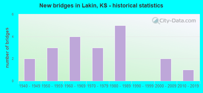
- New bridges - historical statistics
- 21940-1949
- 31950-1959
- 41960-1969
- 31970-1979
- 51980-1989
- 22000-2009
- 12010-2019


- Bridge Condition - Deck
- 54.5%Good
- 45.5%Satisfactory

- Bridge Condition - Superstructure
- 9.1%Very good
- 9.1%Good
- 72.7%Satisfactory
- 9.1%Fair

- Bridge Condition - Substructure
- 9.1%Very good
- 45.5%Good
- 36.4%Satisfactory
- 9.1%Fair

- Bridge Condition - Channel
- 15.0%Very good
- 40.0%Good
- 45.0%Satisfactory

- Bridge Condition - Culverts
- 22.2%Very good
- 44.4%Good
- 22.2%Satisfactory
- 11.1%Fair
Find on map >> Show street view
Structure Number: 4701, Location: 0.5S.W. OF LAKIN (Lat: 37.931389, Lng: -101.268861), Route carried "on" structure: County highway 358, Year Built: 1952, Status: Open, Structure Length: 1.33m (4.36ft), Average Daily Traffic: 500 (year 2018), Truck Traffic: 10%, Average Future Daily Traffic: 600 (year 2041), Design Load: H 15, Features Intersected: SAND CREEK
Minimum Vertical Clearance: 30.47m (99.97ft), Kilometerpoint: 0.000, Lanes on structure: 2, Owner: County Highway Agency, Approaching Roadway Width: 7.4m (24.3ft), Material/Design: Concrete, Design/Construction: Culvert, Number Of Spans In Main Unit: 3, Length of Maximum Span: 4.3m (14.1ft), Curb or Sidewalk Widths: Left: 0.3m (1.0ft), Right: 0.3m (1.0ft), Curb-To-Curb Width: 7.9m (25.9ft), Out-to-Out Width: 8.5m (27.9ft)
Condition: Channel: Satisfactory, Culverts: Satisfactory, Operating Rating: 32.4 metric tons, Method Used To Determine Operating Rating: Allowable Stress (AS), Inventory Rating: 23.6 metric tons, Method Used To Determine Inventory Rating: Allowable Stress (AS), Structural Evaluation: Equal to present minimum criteria, Deck Geometry: Somewhat better than minimum adequacy, Waterway Adequacy: Somewhat better than minimum adequacy, Approach Roadway Alignment: Better than present minimum criteria, Designated Inspection Frequency: Every 24 months, Inspection Date: November 2021, Deck Structure Type: Concrete Cast-file-Place, Wearing Surface/Protective System: Wearing Surface: Gravel
Find on map >> Show street view
Structure Number: 470385005828, Location: 0.5N 3.6W OF LAKIN (Lat: 37.946667, Lng: -101.322167), Route carried "on" structure: County highway , Year Built: 1978, Status: Posted for load, Structure Length: 1.10m (3.61ft), Average Daily Traffic: 80 (year 2018), Truck Traffic: 5%, Average Future Daily Traffic: 80 (year 2041), Design Load: H 20, Features Intersected: TRIB. TO SAND CREEK, Facility Carried by Structure: LOCAL RD. N
Minimum Vertical Clearance: 30.47m (99.97ft), Kilometerpoint: 0.000, Lanes on structure: 2, Owner: County Highway Agency, Approaching Roadway Width: 7.8m (25.6ft), Skew: 3 degrees, Material/Design: Concrete, Design/Construction: Culvert, Number Of Spans In Main Unit: 3, Length of Maximum Span: 3.5m (11.5ft), Curb-To-Curb Width: 9.1m (29.9ft), Out-to-Out Width: 10.1m (33.1ft)
Condition: Channel: Good, Culverts: Satisfactory, Operating Rating: 31.7 metric tons, Method Used To Determine Operating Rating: Load Factor (LF), Inventory Rating: 19.0 metric tons, Method Used To Determine Inventory Rating: Load Factor (LF), Structural Evaluation: Somewhat better than minimum adequacy, Deck Geometry: Better than present minimum criteria, Waterway Adequacy: Equal to present minimum criteria, Approach Roadway Alignment: Better than present minimum criteria, Bridge Posting: Required (Relationship of Operating Rating to Maximum Legal Load: 20.0 - 29.9% below), Designated Inspection Frequency: Every 24 months, Inspection Date: November 2021, Deck Structure Type: Concrete Cast-file-Place, Wearing Surface/Protective System: Wearing Surface: Gravel
Find on map >> Show street view
Structure Number: 470385005847, Location: 0.4S 3.6W OF LAKIN (Lat: 37.934967, Lng: -101.322178), Route carried "on" structure: County highway , Year Built: 1978, Status: Posted for load, Structure Length: 1.01m (3.31ft), Average Daily Traffic: 100 (year 2018), Truck Traffic: 5%, Average Future Daily Traffic: 100 (year 2041), Design Load: H 20, Features Intersected: SAND CREEK, Facility Carried by Structure: LOCAL RD. N
Minimum Vertical Clearance: 30.47m (99.97ft), Kilometerpoint: 0.000, Lanes on structure: 2, Owner: County Highway Agency, Approaching Roadway Width: 7.7m (25.3ft), Skew: 3 degrees, Material/Design: Concrete, Design/Construction: Culvert, Number Of Spans In Main Unit: 2, Length of Maximum Span: 4.9m (16.1ft), Curb-To-Curb Width: 9.0m (29.5ft), Out-to-Out Width: 10.1m (33.1ft)
Condition: Channel: Good, Culverts: Good, Operating Rating: 30.2 metric tons, Method Used To Determine Operating Rating: Load Factor (LF), Inventory Rating: 18.1 metric tons, Method Used To Determine Inventory Rating: Load Factor (LF), Structural Evaluation: Somewhat better than minimum adequacy, Deck Geometry: Better than present minimum criteria, Waterway Adequacy: Equal to present minimum criteria, Approach Roadway Alignment: Better than present minimum criteria, Bridge Posting: Required (Relationship of Operating Rating to Maximum Legal Load: 30.0 - 39.9% below), Designated Inspection Frequency: Every 24 months, Inspection Date: November 2021, Deck Structure Type: Concrete Cast-file-Place, Wearing Surface/Protective System: Wearing Surface: Gravel
Find on map >> Show street view
Structure Number: 470387005903, Location: 2.7W 3.0S OF LAKIN (Lat: 37.896833, Lng: -101.285667), Route carried "on" structure: County highway , Year Built: 1986, Status: Open, Structure Length: 0.73m (2.40ft), Average Daily Traffic: 25 (year 2018), Truck Traffic: 5%, Average Future Daily Traffic: 25 (year 2041), Features Intersected: SOUTHSIDE DITCH, Facility Carried by Structure: Local RD. R
Minimum Vertical Clearance: 30.47m (99.97ft), Kilometerpoint: 0.000, Lanes on structure: 2, Owner: County Highway Agency, Approaching Roadway Width: 6.1m (20.0ft), Skew: 2 degrees, Material/Design: Steel, Design/Construction: Stringer/Multi-beam, Number Of Spans In Main Unit: 1, Length of Maximum Span: 6.9m (22.6ft), Curb-To-Curb Width: 9.7m (31.8ft), Out-to-Out Width: 9.7m (31.8ft)
Condition: Deck: Good, Superstructure: Satisfactory, Substructure: Satisfactory, Channel: Satisfactory, Operating Rating: 59.1 metric tons, Method Used To Determine Operating Rating: Load Factor (LF), Inventory Rating: 35.4 metric tons, Method Used To Determine Inventory Rating: Load Factor (LF), Structural Evaluation: Equal to present minimum criteria, Deck Geometry: Better than present minimum criteria, Waterway Adequacy: Equal to present minimum criteria, Approach Roadway Alignment: Better than present minimum criteria, Designated Inspection Frequency: Every 24 months, Inspection Date: November 2021, Deck Structure Type: Concrete Cast-file-Place, Wearing Surface/Protective System: Wearing Surface: Gravel
Find on map >> Show street view
Structure Number: 47038770586, Location: 2.0W 0.7S OF LAKIN (Lat: 37.929722, Lng: -101.292583), Route carried "on" structure: County highway , Year Built: 1981, Status: Open, Structure Length: 1.29m (4.23ft), Average Daily Traffic: 40 (year 2018), Truck Traffic: 5%, Average Future Daily Traffic: 75 (year 2041), Design Load: H 20, Features Intersected: AMAZON DITCH, Facility Carried by Structure: LOCAL RD. 140
Minimum Vertical Clearance: 30.47m (99.97ft), Kilometerpoint: 0.000, Lanes on structure: 2, Owner: County Highway Agency, Approaching Roadway Width: 7.8m (25.6ft), Skew: 4 degrees, Material/Design: Concrete, Design/Construction: Culvert, Number Of Spans In Main Unit: 1, Length of Maximum Span: 12.9m (42.3ft), Curb-To-Curb Width: 11.3m (37.1ft), Out-to-Out Width: 12.0m (39.4ft)
Condition: Channel: Satisfactory, Culverts: Fair, Operating Rating: 56.4 metric tons, Method Used To Determine Operating Rating: Load Factor (LF), Inventory Rating: 33.7 metric tons, Method Used To Determine Inventory Rating: Load Factor (LF), Structural Evaluation: Somewhat better than minimum adequacy, Deck Geometry: Superior to present desirable criteria, Waterway Adequacy: Equal to present minimum criteria, Approach Roadway Alignment: Better than present minimum criteria, Designated Inspection Frequency: Every 24 months, Inspection Date: November 2021, Deck Structure Type: Concrete Cast-file-Place, Wearing Surface/Protective System: Wearing Surface: Gravel
Find on map >> Show street view
Structure Number: 47038960566, Location: 9.0N 0.5W OF LAKIN (Lat: 38.075500, Lng: -101.273028), Route carried "on" structure: County highway , Year Built: 1981, Status: Posted for load, Structure Length: 0.98m (3.22ft), Average Daily Traffic: 20 (year 2018), Truck Traffic: 5%, Average Future Daily Traffic: 20 (year 2041), Features Intersected: TRIB. TO MATTOX DRAW, Facility Carried by Structure: LOCAL RD. 240
Minimum Vertical Clearance: 30.47m (99.97ft), Kilometerpoint: 0.000, Lanes on structure: 2, Owner: County Highway Agency, Approaching Roadway Width: 6.8m (22.3ft), Material/Design: Steel, Design/Construction: Stringer/Multi-beam, Number Of Spans In Main Unit: 1, Length of Maximum Span: 9.4m (30.8ft), Curb-To-Curb Width: 9.0m (29.5ft), Out-to-Out Width: 9.1m (29.9ft)
Condition: Deck: Good, Superstructure: Satisfactory, Substructure: Good, Channel: Satisfactory, Operating Rating: 23.4 metric tons, Method Used To Determine Operating Rating: Load Factor (LF), Inventory Rating: 14.0 metric tons, Method Used To Determine Inventory Rating: Load Factor (LF), Structural Evaluation: Meets minimum limits, Deck Geometry: Better than present minimum criteria, Waterway Adequacy: Equal to present minimum criteria, Approach Roadway Alignment: Better than present minimum criteria, Bridge Posting: Required (Relationship of Operating Rating to Maximum Legal Load: > 39.9% below), Designated Inspection Frequency: Every 24 months, Inspection Date: November 2021, Deck Structure Type: Concrete Cast-file-Place, Wearing Surface/Protective System: Wearing Surface: Gravel
Find on map >> Show street view
Structure Number: 4703897059, Location: 1.0W 2.6S OF LAKIN (Lat: 37.900786, Lng: -101.274611), Route carried "on" structure: County highway , Year Built: 1966, Status: Posted for load, Structure Length: 0.81m (2.66ft), Average Daily Traffic: 25 (year 2018), Truck Traffic: 5%, Average Future Daily Traffic: 25 (year 2041), Features Intersected: SOUTHSIDE DITCH, Facility Carried by Structure: LOCAL RD. 120
Minimum Vertical Clearance: 30.47m (99.97ft), Kilometerpoint: 0.000, Lanes on structure: 2, Owner: County Highway Agency, Approaching Roadway Width: 6.1m (20.0ft), Skew: 6 degrees, Material/Design: Steel, Design/Construction: Stringer/Multi-beam, Number Of Spans In Main Unit: 1, Length of Maximum Span: 7.6m (24.9ft), Curb-To-Curb Width: 7.9m (25.9ft), Out-to-Out Width: 8.0m (26.2ft)
Condition: Deck: Satisfactory, Superstructure: Satisfactory, Substructure: Fair, Channel: Satisfactory, Operating Rating: 14.9 metric tons, Method Used To Determine Operating Rating: Load Factor (LF), Inventory Rating: 9.0 metric tons, Method Used To Determine Inventory Rating: Load Factor (LF), Structural Evaluation: High priority of replacement, Deck Geometry: Equal to present minimum criteria, Waterway Adequacy: Equal to present minimum criteria, Approach Roadway Alignment: Better than present minimum criteria, Bridge Posting: Required (Relationship of Operating Rating to Maximum Legal Load: > 39.9% below), Length Of Structure Improvement: 1.22m (4.00ft), Designated Inspection Frequency: Every 24 months, Inspection Date: November 2021, Bridge Improvement Cost: $180,000, Roadway Improvement Cost: $80,000, Total Project Cost: $260,000 ( Estimate for 2021), Deck Structure Type: Corrugated Steel, Wearing Surface/Protective System: Wearing Surface: Gravel
Find on map >> Show street view
Structure Number: 470389805846, Location: W. EDGE OF LAKIN (Lat: 37.936944, Lng: -101.267889), Route carried "on" structure: County highway , Year Built: 1968, Status: Posted for load, Structure Length: 0.67m (2.20ft), Average Daily Traffic: 100 (year 2018), Truck Traffic: 5%, Average Future Daily Traffic: 100 (year 2041), Features Intersected: W. LAKIN WATERSHED, Facility Carried by Structure: LOCAL RD (LINCOLN)
Minimum Vertical Clearance: 30.47m (99.97ft), Kilometerpoint: 0.000, Lanes on structure: 2, Owner: County Highway Agency, Approaching Roadway Width: 5.9m (19.4ft), Material/Design: Steel, Design/Construction: Stringer/Multi-beam, Number Of Spans In Main Unit: 1, Length of Maximum Span: 6.4m (21.0ft), Curb-To-Curb Width: 7.9m (25.9ft), Out-to-Out Width: 8.0m (26.2ft)
Condition: Deck: Good, Superstructure: Satisfactory, Substructure: Good, Channel: Good, Operating Rating: 35.9 metric tons, Method Used To Determine Operating Rating: Load Factor (LF), Inventory Rating: 21.5 metric tons, Method Used To Determine Inventory Rating: Load Factor (LF), Structural Evaluation: Equal to present minimum criteria, Deck Geometry: Equal to present minimum criteria, Waterway Adequacy: Equal to present minimum criteria, Approach Roadway Alignment: Better than present minimum criteria, Bridge Posting: Required (Relationship of Operating Rating to Maximum Legal Load: 10.0 - 19.9% below), Designated Inspection Frequency: Every 24 months, Inspection Date: November 2021, Deck Structure Type: Concrete Cast-file-Place, Wearing Surface/Protective System: Wearing Surface: Monolithic Concrete
Find on map >> Show street view
Structure Number: 47039120582, Location: 0.4W 1.3N OF LAKIN (Lat: 37.958833, Lng: -101.264639), Route carried "on" structure: County highway , Year Built: 1964, Status: Posted for load, Structure Length: 1.04m (3.41ft), Average Daily Traffic: 100 (year 2018), Truck Traffic: 5%, Average Future Daily Traffic: 100 (year 2041), Features Intersected: AMAZON DITCH, Facility Carried by Structure: LOCAL RD. 160
Minimum Vertical Clearance: 30.47m (99.97ft), Kilometerpoint: 0.000, Lanes on structure: 2, Owner: County Highway Agency, Approaching Roadway Width: 6.3m (20.7ft), Material/Design: Steel, Design/Construction: Stringer/Multi-beam, Number Of Spans In Main Unit: 1, Length of Maximum Span: 9.6m (31.5ft), Curb-To-Curb Width: 7.9m (25.9ft), Out-to-Out Width: 7.9m (25.9ft)
Condition: Deck: Satisfactory, Superstructure: Fair, Substructure: Satisfactory, Channel: Satisfactory, Operating Rating: 18.9 metric tons, Method Used To Determine Operating Rating: Load Factor (LF), Inventory Rating: 11.4 metric tons, Method Used To Determine Inventory Rating: Load Factor (LF), Structural Evaluation: Meets minimum limits, Deck Geometry: Equal to present minimum criteria, Waterway Adequacy: Equal to present minimum criteria, Approach Roadway Alignment: Better than present minimum criteria, Bridge Posting: Required (Relationship of Operating Rating to Maximum Legal Load: 20.0 - 29.9% below), Designated Inspection Frequency: Every 24 months, Inspection Date: November 2021, Deck Structure Type: Corrugated Steel, Wearing Surface/Protective System: Wearing Surface: Bituminous
Find on map >> Show street view
Structure Number: 470391805807, Location: 1.6N 0.1E OF LAKIN (Lat: 37.964764, Lng: -101.254017), Route carried "on" structure: County highway , Year Built: 2015, Status: Open, Structure Length: 0.73m (2.40ft), Average Daily Traffic: 90 (year 2018), Truck Traffic: 5%, Average Future Daily Traffic: 90 (year 2041), Design Load: HL 93, Features Intersected: AMAZON DITCH, Facility Carried by Structure: T Road
Minimum Vertical Clearance: 30.47m (99.97ft), Kilometerpoint: 0.000, Lanes on structure: 2, Owner: County Highway Agency, Approaching Roadway Width: 7.4m (24.3ft), Material/Design: Concrete, Design/Construction: Culvert, Number Of Spans In Main Unit: 1, Length of Maximum Span: 7.3m (24.0ft), Curb or Sidewalk Widths: Left: 0.4m (1.3ft), Right: 0.4m (1.3ft), Curb-To-Curb Width: 11.6m (38.1ft), Out-to-Out Width: 12.3m (40.4ft)
Condition: Channel: Good, Culverts: Very good, Operating Rating: 61.6 metric tons, Method Used To Determine Operating Rating: Load and Resistance Factor Rating (LRFR) rating reported by rating factor(RF) method using HL-93 loadings, Inventory Rating: 47.6 metric tons, Method Used To Determine Inventory Rating: Load and Resistance Factor Rating (LRFR) rating reported by rating factor(RF) method using HL-93 loadings, Structural Evaluation: Equal to present desirable criteria, Deck Geometry: Superior to present desirable criteria, Waterway Adequacy: Better than present minimum criteria, Approach Roadway Alignment: Equal to present minimum criteria, Designated Inspection Frequency: Every 24 months, Inspection Date: November 2021, Deck Structure Type: Concrete Cast-file-Place, Wearing Surface/Protective System: Wearing Surface: Bituminous
Find on map >> Show street view
Structure Number: 470393005801, Location: 0.3E 2.1N OF LAKIN (Lat: 37.972167, Lng: -101.249333), Route carried "on" structure: County highway , Year Built: 1953, Status: Open, Structure Length: 0.73m (2.40ft), Average Daily Traffic: 80 (year 2018), Truck Traffic: 5%, Average Future Daily Traffic: 80 (year 2041), Design Load: H 15, Features Intersected: AMAZON DITCH, Facility Carried by Structure: MINOR COL (RD T)
Minimum Vertical Clearance: 30.47m (99.97ft), Kilometerpoint: 0.000, Lanes on structure: 2, Owner: County Highway Agency, Approaching Roadway Width: 7.0m (23.0ft), Material/Design: Concrete, Design/Construction: Culvert, Number Of Spans In Main Unit: 1, Length of Maximum Span: 7.3m (24.0ft), Curb-To-Curb Width: 7.9m (25.9ft), Out-to-Out Width: 8.5m (27.9ft)
Condition: Channel: Good, Culverts: Good, Operating Rating: 32.4 metric tons, Method Used To Determine Operating Rating: Allowable Stress (AS), Inventory Rating: 24.3 metric tons, Method Used To Determine Inventory Rating: Allowable Stress (AS), Structural Evaluation: Equal to present minimum criteria, Deck Geometry: Equal to present minimum criteria, Waterway Adequacy: Equal to present minimum criteria, Approach Roadway Alignment: Better than present minimum criteria, Designated Inspection Frequency: Every 24 months, Inspection Date: November 2021, Deck Structure Type: Concrete Cast-file-Place, Wearing Surface/Protective System: Wearing Surface: Monolithic Concrete
Find on map >> Show street view
Structure Number: 47039320584, Location: 0.3E OF LAKIN (Lat: 37.943611, Lng: -101.245056), Route carried "on" structure: County highway , Year Built: 1979, Status: Posted for load, Structure Length: 0.82m (2.69ft), Average Daily Traffic: 20 (year 2018), Truck Traffic: 5%, Average Future Daily Traffic: 20 (year 2041), Features Intersected: LAKIN DRAINAGE DITCH, Facility Carried by Structure: 150 Road
Minimum Vertical Clearance: 30.47m (99.97ft), Kilometerpoint: 0.000, Lanes on structure: 2, Owner: County Highway Agency, Approaching Roadway Width: 3.9m (12.8ft), Skew: 2 degrees, Material/Design: Steel, Design/Construction: Stringer/Multi-beam, Number Of Spans In Main Unit: 1, Length of Maximum Span: 7.9m (25.9ft), Curb-To-Curb Width: 8.6m (28.2ft), Out-to-Out Width: 9.1m (29.9ft)
Condition: Deck: Satisfactory, Superstructure: Satisfactory, Substructure: Satisfactory, Channel: Satisfactory, Operating Rating: 39.5 metric tons, Method Used To Determine Operating Rating: Load Factor (LF), Inventory Rating: 23.6 metric tons, Method Used To Determine Inventory Rating: Load Factor (LF), Structural Evaluation: Equal to present minimum criteria, Deck Geometry: Better than present minimum criteria, Waterway Adequacy: Equal to present minimum criteria, Approach Roadway Alignment: Equal to present minimum criteria, Bridge Posting: Required (Relationship of Operating Rating to Maximum Legal Load: 10.0 - 19.9% below), Designated Inspection Frequency: Every 24 months, Inspection Date: November 2021, Deck Structure Type: Corrugated Steel, Wearing Surface/Protective System: Wearing Surface: Bituminous
Find on map >> Show street view
Structure Number: 470395005882, Location: 1.2E 1.7S OF LAKIN (Lat: 37.912333, Lng: -101.231306), Route carried "on" structure: County highway , Year Built: 1986, Status: Open, Structure Length: 1.11m (3.64ft), Average Daily Traffic: 25 (year 2018), Truck Traffic: 5%, Average Future Daily Traffic: 25 (year 2041), Features Intersected: SOUTHSIDE DITCH, Facility Carried by Structure: LOCAL RD. U
Minimum Vertical Clearance: 30.47m (99.97ft), Kilometerpoint: 0.000, Lanes on structure: 2, Owner: County Highway Agency, Approaching Roadway Width: 6.2m (20.3ft), Skew: 5 degrees, Material/Design: Steel, Design/Construction: Stringer/Multi-beam, Number Of Spans In Main Unit: 1, Length of Maximum Span: 10.3m (33.8ft), Curb-To-Curb Width: 9.8m (32.2ft), Out-to-Out Width: 9.8m (32.2ft)
Condition: Deck: Good, Superstructure: Satisfactory, Substructure: Satisfactory, Channel: Satisfactory, Operating Rating: 56.5 metric tons, Method Used To Determine Operating Rating: Load Factor (LF), Inventory Rating: 33.6 metric tons, Method Used To Determine Inventory Rating: Load Factor (LF), Structural Evaluation: Equal to present minimum criteria, Deck Geometry: Equal to present desirable criteria, Waterway Adequacy: Equal to present minimum criteria, Approach Roadway Alignment: Better than present minimum criteria, Designated Inspection Frequency: Every 24 months, Inspection Date: November 2021, Deck Structure Type: Concrete Cast-file-Place, Wearing Surface/Protective System: Wearing Surface: Gravel
Find on map >> Show street view
Structure Number: 47039580578, Location: 4.3W 0.7N OF DEERFIELD (Lat: 37.988333, Lng: -101.216583), Route carried "on" structure: County highway , Year Built: 1940, Status: Posted for load, Structure Length: 0.73m (2.40ft), Average Daily Traffic: 40 (year 2018), Truck Traffic: 5%, Average Future Daily Traffic: 40 (year 2041), Features Intersected: AMAZON DITCH, Facility Carried by Structure: LOCAL RD. 180
Minimum Vertical Clearance: 30.47m (99.97ft), Kilometerpoint: 0.000, Lanes on structure: 2, Owner: County Highway Agency, Approaching Roadway Width: 7.3m (24.0ft), Material/Design: Steel, Design/Construction: Stringer/Multi-beam, Number Of Spans In Main Unit: 1, Length of Maximum Span: 7.0m (23.0ft), Curb-To-Curb Width: 7.4m (24.3ft), Out-to-Out Width: 7.7m (25.3ft)
Condition: Deck: Satisfactory, Superstructure: Satisfactory, Substructure: Good, Channel: Good, Operating Rating: 27.0 metric tons, Method Used To Determine Operating Rating: Load Factor (LF), Inventory Rating: 15.4 metric tons, Method Used To Determine Inventory Rating: Load Factor (LF), Structural Evaluation: Meets minimum limits, Deck Geometry: Equal to present minimum criteria, Waterway Adequacy: Equal to present minimum criteria, Approach Roadway Alignment: Equal to present minimum criteria, Bridge Posting: Required (Relationship of Operating Rating to Maximum Legal Load: 30.0 - 39.9% below), Designated Inspection Frequency: Every 24 months, Inspection Date: November 2021, Deck Structure Type: Concrete Cast-file-Place, Wearing Surface/Protective System: Wearing Surface: Gravel
Find on map >> Show street view
Structure Number: 47039750586, Location: 3.3S 3.6W OF DEERFIELD (Lat: 37.930000, Lng: -101.204639), Route carried "on" structure: County highway , Year Built: 1966, Status: Posted for load, Structure Length: 0.88m (2.89ft), Average Daily Traffic: 35 (year 2018), Truck Traffic: 5%, Average Future Daily Traffic: 35 (year 2041), Features Intersected: SOUTHSIDE DITCH, Facility Carried by Structure: LOCAL RD. 140
Minimum Vertical Clearance: 30.47m (99.97ft), Kilometerpoint: 0.000, Lanes on structure: 2, Owner: County Highway Agency, Approaching Roadway Width: 6.7m (22.0ft), Skew: 6 degrees, Material/Design: Steel, Design/Construction: Stringer/Multi-beam, Number Of Spans In Main Unit: 1, Length of Maximum Span: 8.2m (26.9ft), Curb-To-Curb Width: 8.5m (27.9ft), Out-to-Out Width: 8.5m (27.9ft)
Condition: Deck: Satisfactory, Superstructure: Satisfactory, Substructure: Good, Channel: Satisfactory, Operating Rating: 14.7 metric tons, Method Used To Determine Operating Rating: Load Factor (LF), Inventory Rating: 8.8 metric tons, Method Used To Determine Inventory Rating: Load Factor (LF), Structural Evaluation: High priority of corrective action, Deck Geometry: Better than present minimum criteria, Waterway Adequacy: Equal to present minimum criteria, Approach Roadway Alignment: Better than present minimum criteria, Bridge Posting: Required (Relationship of Operating Rating to Maximum Legal Load: > 39.9% below), Length Of Structure Improvement: 1.22m (4.00ft), Designated Inspection Frequency: Every 24 months, Inspection Date: November 2021, Bridge Improvement Cost: $180,000, Roadway Improvement Cost: $80,000, Total Project Cost: $260,000 ( Estimate for 2021), Deck Structure Type: Corrugated Steel, Wearing Surface/Protective System: Wearing Surface: Bituminous
Find on map >> Show street view
Structure Number: 999902500470111, Location: 2.08 MI N US50 (Lat: 37.973333, Lng: -101.267500), Route carried "on" structure: State highway 25, Year Built: 1952, Status: Open, Structure Length: 0.96m (3.15ft), Average Daily Traffic: 1,166 (year 2020), Truck Traffic: 16%, Average Future Daily Traffic: 1,570 (year 2041), Design Load: H 20, Features Intersected: AMAZON DITCH DRAINAGE
Minimum Vertical Clearance: 30.47m (99.97ft), Kilometerpoint: 30.487, Lanes on structure: 2, Base Highway Network: Yes, Owner: State Highway Agency, Approaching Roadway Width: 7.3m (24.0ft), Material/Design: Concrete, Design/Construction: Culvert, Number Of Spans In Main Unit: 3, Length of Maximum Span: 3.0m (9.8ft), Curb-To-Curb Width: 8.5m (27.9ft), Out-to-Out Width: 10.5m (34.4ft)
Condition: Channel: Good, Culverts: Good, Operating Rating: 28.9 metric tons, Method Used To Determine Operating Rating: Load Factor (LF), Inventory Rating: 17.3 metric tons, Method Used To Determine Inventory Rating: Load Factor (LF), Structural Evaluation: Meets minimum limits, Deck Geometry: Somewhat better than minimum adequacy, Waterway Adequacy: Equal to present desirable criteria, Approach Roadway Alignment: Better than present minimum criteria, Length Of Structure Improvement: 3.16m (10.37ft), Designated Inspection Frequency: Every 24 months, Inspection Date: April 2021, Deck Structure Type: Concrete Cast-file-Place, Wearing Surface/Protective System: Wearing Surface: Bituminous
Find on map >> Show street view
Structure Number: 999902500470141, Location: 1.59 MI. SOUTH OF US-50 (Lat: 37.924444, Lng: -101.254444), Route carried "on" structure: State highway 25, Year Built: 1983, Status: Open, Structure Length: 22.87m (75.03ft), Average Daily Traffic: 2,538 (year 2020), Truck Traffic: 12%, Average Future Daily Traffic: 3,097 (year 2041), Design Load: HS 20, Features Intersected: ARKANSAS RIVER
Minimum Vertical Clearance: 30.47m (99.97ft), Kilometerpoint: 24.522, Lanes on structure: 2, Base Highway Network: Yes, Owner: State Highway Agency, Approaching Roadway Width: 7.3m (24.0ft), Material/Design: Steel continuous, Design/Construction: Stringer/Multi-beam, Number Of Spans In Main Unit: 13, Length of Maximum Span: 21.9m (71.9ft), Curb-To-Curb Width: 8.5m (27.9ft), Out-to-Out Width: 9.1m (29.9ft)
Condition: Deck: Good, Superstructure: Good, Substructure: Good, Channel: Good, Operating Rating: 72.6 metric tons, Method Used To Determine Operating Rating: Load Factor (LF), Inventory Rating: 43.5 metric tons, Method Used To Determine Inventory Rating: Load Factor (LF), Structural Evaluation: Better than present minimum criteria, Deck Geometry: Meets minimum limits, Waterway Adequacy: Equal to present desirable criteria, Approach Roadway Alignment: Better than present minimum criteria, Length Of Structure Improvement: 75.05m (246.23ft), Designated Inspection Frequency: Every 12 months, Other Special Inspection Frequency: Every 24 months, Inspection Date: April 2021, Other Special Inspection Date: June 2020, Wearing Surface/Protective System: Wearing Surface: Monolithic Concrete, Deck Protection: Epoxy Coated Reinforcing
Find on map >> Show street view
Structure Number: 999902500470191, Location: .75 MI N US-50 (Lat: 37.954444, Lng: -101.266111), Route carried "on" structure: State highway 25, Year Built: 2003, Status: Open, Structure Length: 2.53m (8.30ft), Average Daily Traffic: 1,166 (year 2020), Truck Traffic: 16%, Average Future Daily Traffic: 1,570 (year 2041), Design Load: HS 20, Features Intersected: AMAZON DITCH
Minimum Vertical Clearance: 30.47m (99.97ft), Kilometerpoint: 28.378, Lanes on structure: 2, Base Highway Network: Yes, Owner: State Highway Agency, Approaching Roadway Width: 11.6m (38.1ft), Skew: 3 degrees, Material/Design: Prestressed concrete, Design/Construction: Tee Beam, Number Of Spans In Main Unit: 1, Length of Maximum Span: 25.3m (83.0ft), Curb-To-Curb Width: 11.0m (36.1ft), Out-to-Out Width: 11.6m (38.1ft)
Condition: Deck: Good, Superstructure: Very good, Substructure: Very good, Channel: Very good, Operating Rating: 89.8 metric tons, Method Used To Determine Operating Rating: Load Factor (LF), Inventory Rating: 66.3 metric tons, Method Used To Determine Inventory Rating: Load Factor (LF), Structural Evaluation: Equal to present desirable criteria, Deck Geometry: Equal to present minimum criteria, Waterway Adequacy: Equal to present desirable criteria, Approach Roadway Alignment: Meets minimum limits, Length Of Structure Improvement: 8.30m (27.23ft), Designated Inspection Frequency: Every 24 months, Inspection Date: April 2021, Wearing Surface/Protective System: Wearing Surface: Monolithic Concrete, Deck Protection: Epoxy Coated Reinforcing
Find on map >> Show street view
Structure Number: 999905000470041, Location: 12.22 MI E HAMILTON COLN (Lat: 37.944167, Lng: -101.317778), Route carried "on" structure: US 50, Year Built: 1949, Year Reconstructed: 2000, Status: Open, Structure Length: 0.96m (3.15ft), Average Daily Traffic: 2,177 (year 2020), Truck Traffic: 24%, Average Future Daily Traffic: 2,405 (year 2041), Design Load: H 20, Features Intersected: SAND CREEK DRAINAGE
Minimum Vertical Clearance: 30.47m (99.97ft), Kilometerpoint: 19.657, Lanes on structure: 2, Base Highway Network: Yes, Owner: State Highway Agency, Approaching Roadway Width: 13.4m (44.0ft), Material/Design: Concrete, Design/Construction: Culvert, Number Of Spans In Main Unit: 3, Length of Maximum Span: 3.0m (9.8ft), Curb-To-Curb Width: 13.4m (44.0ft), Out-to-Out Width: 25.2m (82.7ft)
Condition: Channel: Very good, Culverts: Good, Operating Rating: 36.6 metric tons, Method Used To Determine Operating Rating: Load Factor (LF), Inventory Rating: 21.9 metric tons, Method Used To Determine Inventory Rating: Load Factor (LF), Structural Evaluation: Somewhat better than minimum adequacy, Deck Geometry: Better than present minimum criteria, Waterway Adequacy: Equal to present desirable criteria, Approach Roadway Alignment: Equal to present desirable criteria, Length Of Structure Improvement: 3.16m (10.37ft), Designated Inspection Frequency: Every 24 months, Inspection Date: April 2021, Deck Structure Type: Concrete Cast-file-Place, Wearing Surface/Protective System: Wearing Surface: Bituminous
Find on map >> Show street view
Structure Number: 999905000470181, Location: 1.02 MI W K-25 HWY (Lat: 37.944167, Lng: -101.276944), Route carried "on" structure: US 50, Year Built: 2002, Status: Open, Structure Length: 0.73m (2.40ft), Average Daily Traffic: 2,487 (year 2020), Truck Traffic: 29%, Average Future Daily Traffic: 2,748 (year 2041), Design Load: HS 25 or greater, Features Intersected: AMAZON CANAL
Minimum Vertical Clearance: 30.47m (99.97ft), Kilometerpoint: 23.258, Lanes on structure: 2, Base Highway Network: Yes, Owner: State Highway Agency, Approaching Roadway Width: 13.4m (44.0ft), Material/Design: Concrete, Design/Construction: Culvert, Number Of Spans In Main Unit: 1, Length of Maximum Span: 7.3m (24.0ft), Curb-To-Curb Width: 18.2m (59.7ft), Out-to-Out Width: 19.0m (62.3ft)
Condition: Channel: Very good, Culverts: Very good, Operating Rating: 54.4 metric tons, Method Used To Determine Operating Rating: Load Factor (LF), Inventory Rating: 32.7 metric tons, Method Used To Determine Inventory Rating: Load Factor (LF), Structural Evaluation: Equal to present desirable criteria, Deck Geometry: Superior to present desirable criteria, Waterway Adequacy: Equal to present desirable criteria, Approach Roadway Alignment: Equal to present desirable criteria, Length Of Structure Improvement: 2.40m (7.87ft), Designated Inspection Frequency: Every 24 months, Inspection Date: April 2021, Deck Structure Type: Concrete Cast-file-Place, Wearing Surface/Protective System: Wearing Surface: Bituminous