Bridge Statistics for Lamar, Arkansas (AR)
Condition, Traffic, Stress, Structural Evaluation, Project Costs
- National Bridge Inventory (NBI) Statistics
- 24Number of bridges
- 210ft / 64.2mTotal length
- $674,000Total costs
- 138,310Total average daily traffic
- 32,624Total average daily truck traffic
- National Bridge Inventory (NBI) Registered Bridges for Lamar
- No street view available for this location
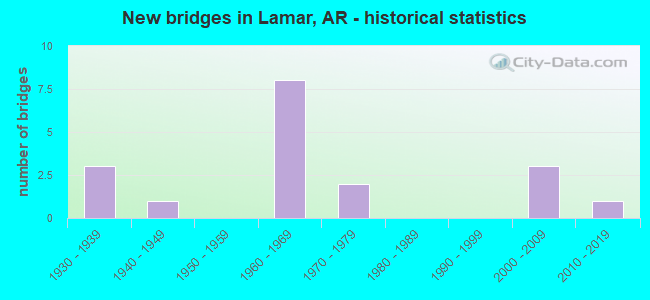
- New bridges - historical statistics
- 31930-1939
- 11940-1949
- 81960-1969
- 21970-1979
- 32000-2009
- 12010-2019


- Bridge Condition - Deck
- 16.7%Very good
- 25.0%Good
- 33.3%Satisfactory
- 25.0%Fair

- Bridge Condition - Superstructure
- 16.7%Very good
- 8.3%Good
- 58.3%Satisfactory
- 16.7%Fair

- Bridge Condition - Substructure
- 41.7%Good
- 33.3%Satisfactory
- 25.0%Fair

- Bridge Condition - Channel
- 7.7%Very good
- 76.9%Good
- 15.4%Satisfactory

- Bridge Condition - Culverts
- 33.3%Very good
- 66.7%Good
Find on map >> Show street view
Structure Number: 2539, Location: 1 MI W SH 123 (Lat: 35.478183, Lng: -93.402500), Route carried "on" structure: State highway 164, Year Built: 1947, Status: Open, Structure Length: 0.98m (3.22ft), Average Daily Traffic: 490 (year 2018), Truck Traffic: 1%, Average Future Daily Traffic: 656 (year 2028), Design Load: H 15, Features Intersected: Greenbrair Creek
Minimum Vertical Clearance: 30+ m (98+ ft), Kilometerpoint: 4.023, Lanes on structure: 2, Owner: State Highway Agency, Approaching Roadway Width: 7.0m (23.0ft), Material/Design: Steel, Design/Construction: Stringer/Multi-beam, Number Of Spans In Main Unit: 1, Length of Maximum Span: 9.8m (32.2ft), Curb or Sidewalk Widths: Left: 0.5m (1.6ft), Right: 0.5m (1.6ft), Curb-To-Curb Width: 6.0m (19.7ft), Out-to-Out Width: 7.7m (25.3ft)
Condition: Deck: Satisfactory, Superstructure: Satisfactory, Substructure: Satisfactory, Channel: Good, Operating Rating: 39.9 metric tons, Method Used To Determine Operating Rating: Load Factor (LF), Inventory Rating: 23.6 metric tons, Method Used To Determine Inventory Rating: Load Factor (LF), Structural Evaluation: Equal to present minimum criteria, Deck Geometry: High priority of replacement, Waterway Adequacy: Better than present minimum criteria, Approach Roadway Alignment: Equal to present desirable criteria, Length Of Structure Improvement: 1.68m (5.51ft), Designated Inspection Frequency: Every 24 months, Critical Feature Inspection Frequency: Every 24 months, Inspection Date: May 2020, Roadway Improvement Cost: $109,000, Total Project Cost: $218,000, Deck Structure Type: Concrete Cast-file-Place, Wearing Surface/Protective System: Wearing Surface: Bituminous
Find on map >> Show street view
Structure Number: 3862, Location: 0.50 mile west of SH 64 (Lat: 35.434639, Lng: -93.412697), Route carried "on" structure: County highway 39, Year Built: 1965, Status: Open, Structure Length: 9.94m (32.61ft), Average Daily Traffic: 343 (year 1987), Truck Traffic: 1%, Average Future Daily Traffic: 166 (year 2007), Design Load: H 15, Features Intersected: I 40-SEC 21, Facility Carried by Structure: Riverpoint Rd
Minimum Vertical Clearance: 30+ m (98+ ft), Kilometerpoint: 2.414, Lanes on structure: 2, Lanes under structure: 4, Owner: State Highway Agency, Approaching Roadway Width: 8.2m (26.9ft), Skew: 5 degrees, Material/Design: Steel, Design/Construction: Stringer/Multi-beam, Number Of Spans In Main Unit: 5, Length of Maximum Span: 20.7m (67.9ft), Curb or Sidewalk Widths: Left: 0.3m (1.0ft), Right: 0.3m (1.0ft), Curb-To-Curb Width: 7.3m (24.0ft), Out-to-Out Width: 8.7m (28.5ft)
Condition: Deck: Satisfactory, Superstructure: Satisfactory, Substructure: Good, Operating Rating: 47.2 metric tons, Method Used To Determine Operating Rating: Load Factor (LF), Inventory Rating: 28.1 metric tons, Method Used To Determine Inventory Rating: Load Factor (LF), Structural Evaluation: Equal to present minimum criteria, Deck Geometry: Somewhat better than minimum adequacy, Underclear: High priority of corrective action, Approach Roadway Alignment: Equal to present desirable criteria, Designated Inspection Frequency: Every 24 months, Critical Feature Inspection Frequency: Every 24 months, Inspection Date: Febuary 2020, Deck Structure Type: Concrete Cast-file-Place, Wearing Surface/Protective System: Wearing Surface: Monolithic Concrete
Find on map >> Show street view
Structure Number: 6756, Location: 0.20 MI. W. JCT.SH 315 (Lat: 35.448250, Lng: -93.337939), Route carried "on" structure: State highway 359, Year Built: 2001, Status: Open, Structure Length: 11.22m (36.81ft), Average Daily Traffic: 999 (year 2018), Truck Traffic: 5%, Average Future Daily Traffic: 1,338 (year 2028), Design Load: HS 20, Features Intersected: Little Piney Creek
Minimum Vertical Clearance: 30+ m (98+ ft), Kilometerpoint: 15.981, Lanes on structure: 2, Owner: State Highway Agency, Approaching Roadway Width: 9.9m (32.5ft), Material/Design: Steel, Design/Construction: Stringer/Multi-beam, Number Of Spans In Main Unit: 7, Length of Maximum Span: 16.2m (53.1ft), Curb-To-Curb Width: 9.6m (31.5ft), Out-to-Out Width: 10.5m (34.4ft)
Condition: Deck: Good, Superstructure: Good, Substructure: Good, Channel: Satisfactory, Operating Rating: 54.4 metric tons, Method Used To Determine Operating Rating: Load Factor (LF), Inventory Rating: 32.7 metric tons, Method Used To Determine Inventory Rating: Load Factor (LF), Structural Evaluation: Better than present minimum criteria, Deck Geometry: Equal to present minimum criteria, Waterway Adequacy: Equal to present desirable criteria, Approach Roadway Alignment: Equal to present desirable criteria, Designated Inspection Frequency: Every 24 months, Critical Feature Inspection Frequency: Every 24 months, Inspection Date: October 2021, Deck Structure Type: Concrete Cast-file-Place, Wearing Surface/Protective System: Wearing Surface: Monolithic Concrete
Find on map >> Show street view
Structure Number: 1436, Location: .55 W Hwy 64 (Lat: 35.415889, Lng: -93.389944), Route carried "on" structure: County highway 42, Year Built: 1970, Status: Posted for load, Structure Length: 0.73m (2.40ft), Average Daily Traffic: 203 (year 2018), Truck Traffic: 1%, Average Future Daily Traffic: 235 (year 2007), Features Intersected: Creek, Facility Carried by Structure: Red Oak Rd.
Minimum Vertical Clearance: 30+ m (98+ ft), Kilometerpoint: 0.885, Lanes on structure: 2, Owner: County Highway Agency, Approaching Roadway Width: 5.5m (18.0ft), Material/Design: Concrete, Design/Construction: Slab, Number Of Spans In Main Unit: 1, Length of Maximum Span: 7.3m (24.0ft), Curb or Sidewalk Widths: Left: 0.3m (1.0ft), Right: 0.3m (1.0ft), Curb-To-Curb Width: 4.9m (16.1ft), Out-to-Out Width: 5.5m (18.0ft)
Condition: Deck: Satisfactory, Superstructure: Satisfactory, Substructure: Good, Channel: Good, Operating Rating: 28.1 metric tons, Method Used To Determine Operating Rating: Load Factor (LF), Inventory Rating: 17.2 metric tons, Method Used To Determine Inventory Rating: Load Factor (LF), Structural Evaluation: Somewhat better than minimum adequacy, Deck Geometry: High priority of replacement, Waterway Adequacy: Better than present minimum criteria, Approach Roadway Alignment: Equal to present desirable criteria, Bridge Posting: Required (Relationship of Operating Rating to Maximum Legal Load: 20.0 - 29.9% below), Length Of Structure Improvement: 1.43m (4.69ft), Designated Inspection Frequency: Every 24 months, Critical Feature Inspection Frequency: Every 24 months, Inspection Date: Febuary 2022, Roadway Improvement Cost: $109,000, Total Project Cost: $207,000, Deck Structure Type: Concrete Cast-file-Place, Wearing Surface/Protective System: Wearing Surface: Gravel
Find on map >> Show street view
Structure Number: 14361, Location: .98 M NW CORD 42 & SH 64 (Lat: 35.420111, Lng: -93.394889), Route carried "on" structure: County highway 42, Year Built: 1930, Status: Open, Structure Length: 1.65m (5.41ft), Average Daily Traffic: 203 (year 2018), Truck Traffic: 1%, Average Future Daily Traffic: 235 (year 2007), Features Intersected: Cabin Creek, Facility Carried by Structure: Red Oak Rd.
Minimum Vertical Clearance: 30+ m (98+ ft), Kilometerpoint: 1.577, Lanes on structure: 2, Owner: County Highway Agency, Approaching Roadway Width: 4.9m (16.1ft), Material/Design: Concrete, Design/Construction: Stringer/Multi-beam, Number Of Spans In Main Unit: 1, Length of Maximum Span: 16.5m (54.1ft), Curb-To-Curb Width: 4.9m (16.1ft), Out-to-Out Width: 6.1m (20.0ft)
Condition: Deck: Satisfactory, Superstructure: Fair, Substructure: Satisfactory, Channel: Good, Operating Rating: 52.6 metric tons, Method Used To Determine Operating Rating: Load Factor (LF), Inventory Rating: 31.8 metric tons, Method Used To Determine Inventory Rating: Load Factor (LF), Structural Evaluation: Somewhat better than minimum adequacy, Deck Geometry: High priority of replacement, Waterway Adequacy: Equal to present desirable criteria, Approach Roadway Alignment: Somewhat better than minimum adequacy, Length Of Structure Improvement: 2.38m (7.81ft), Designated Inspection Frequency: Every 24 months, Critical Feature Inspection Frequency: Every 24 months, Inspection Date: Febuary 2021, Roadway Improvement Cost: $109,000, Total Project Cost: $249,000, Deck Structure Type: Concrete Cast-file-Place, Wearing Surface/Protective System: Wearing Surface: Monolithic Concrete
Find on map >> Show street view
Structure Number: 19233, Location: .40 Mi So HWY 64 (Lat: 35.438450, Lng: -93.392806), Route carried "on" structure: City street 14200, Year Built: 1976, Status: Posted for load, Structure Length: 1.07m (3.51ft), Average Daily Traffic: 453 (year 2018), Truck Traffic: 1%, Average Future Daily Traffic: 749 (year 2007), Features Intersected: Cabin Creek, Facility Carried by Structure: S. Cumberland St
Minimum Vertical Clearance: 30+ m (98+ ft), Kilometerpoint: 0.595, Lanes on structure: 2, Owner: City or Municipal Highway Agency, Approaching Roadway Width: 6.2m (20.3ft), Material/Design: Concrete, Design/Construction: Slab, Number Of Spans In Main Unit: 2, Length of Maximum Span: 5.2m (17.1ft), Curb or Sidewalk Widths: Left: 1.5m (4.9ft), Right: 0.0m, Curb-To-Curb Width: 7.6m (24.9ft), Out-to-Out Width: 8.2m (26.9ft)
Condition: Deck: Fair, Superstructure: Fair, Substructure: Fair, Channel: Good, Operating Rating: 32.7 metric tons, Method Used To Determine Operating Rating: Load Factor (LF), Inventory Rating: 20.0 metric tons, Method Used To Determine Inventory Rating: Load Factor (LF), Structural Evaluation: Somewhat better than minimum adequacy, Deck Geometry: Meets minimum limits, Waterway Adequacy: Better than present minimum criteria, Approach Roadway Alignment: Equal to present desirable criteria, Designated Inspection Frequency: Every 24 months, Critical Feature Inspection Frequency: Every 24 months, Inspection Date: May 2021, Deck Structure Type: Concrete Cast-file-Place, Wearing Surface/Protective System: Wearing Surface: Integral Concrete
Find on map >> Show street view
Structure Number: 233, Location: 0.35 Mi. S. of SH 64 (Lat: 35.437358, Lng: -93.391667), Route carried "on" structure: City street 17950, Year Built: 2010, Status: Open, Structure Length: 1.21m (3.97ft), Average Daily Traffic: 390 (year 2018), Truck Traffic: 15%, Average Future Daily Traffic: 2,200 (year 2030), Design Load: HS 20+Mod, Features Intersected: Cabin Creek, Facility Carried by Structure: Elberta Street
Minimum Vertical Clearance: 30+ m (98+ ft), Kilometerpoint: 0.386, Lanes on structure: 2, Owner: City or Municipal Highway Agency, Approaching Roadway Width: 7.3m (24.0ft), Material/Design: Concrete, Design/Construction: Culvert, Number Of Spans In Main Unit: 3, Length of Maximum Span: 3.7m (12.1ft), Curb or Sidewalk Widths: Left: 1.5m (4.9ft), Right: 1.5m (4.9ft)
Condition: Channel: Very good, Culverts: Very good, Operating Rating: 31.8 metric tons, Method Used To Determine Operating Rating: Load Factor (LF), Inventory Rating: 19.1 metric tons, Method Used To Determine Inventory Rating: Load Factor (LF), Structural Evaluation: Somewhat better than minimum adequacy, Waterway Adequacy: Equal to present desirable criteria, Approach Roadway Alignment: Equal to present desirable criteria, Designated Inspection Frequency: Every 24 months, Critical Feature Inspection Frequency: Every 24 months, Inspection Date: September 2020
Find on map >> Show street view
Structure Number: A3778, Location: 2.07 MI N SH 315 (Lat: 35.405122, Lng: -93.378953), Route carried "on" structure: Interstate 40, Year Built: 1965, Status: Open, Structure Length: 3.38m (11.09ft), Average Daily Traffic: 13,000 (year 2018), Truck Traffic: 38%, Average Future Daily Traffic: 17,392 (year 2028), Design Load: HS 20+Mod, Features Intersected: CR 43
Minimum Vertical Clearance: 30+ m (98+ ft), Kilometerpoint: 103.883, Lanes on structure: 2, Lanes under structure: 2, Base Highway Network: Yes, Owner: State Highway Agency, Approaching Roadway Width: 12.8m (42.0ft), Material/Design: Steel, Design/Construction: Stringer/Multi-beam, Number Of Spans In Main Unit: 3, Length of Maximum Span: 11.9m (39.0ft), Curb or Sidewalk Widths: Left: 0.5m (1.6ft), Right: 0.5m (1.6ft), Curb-To-Curb Width: 12.2m (40.0ft), Out-to-Out Width: 13.9m (45.6ft)
Condition: Deck: Very good, Superstructure: Satisfactory, Substructure: Satisfactory, Operating Rating: 52.6 metric tons, Method Used To Determine Operating Rating: Load Factor (LF), Inventory Rating: 31.8 metric tons, Method Used To Determine Inventory Rating: Load Factor (LF), Structural Evaluation: Equal to present minimum criteria, Deck Geometry: Better than present minimum criteria, Underclear: Somewhat better than minimum adequacy, Approach Roadway Alignment: Equal to present desirable criteria, Designated Inspection Frequency: Every 24 months, Critical Feature Inspection Frequency: Every 24 months, Inspection Date: Febuary 2020, Deck Structure Type: Concrete Cast-file-Place, Wearing Surface/Protective System: Wearing Surface: Latex Concrete
Find on map >> Show street view
Structure Number: A3947, Location: 0.73 M NW Jct US 64 (Lat: 35.421178, Lng: -93.393939), Route carried "on" structure: Interstate 40, Year Built: 1965, Status: Open, Structure Length: 6.61m (21.69ft), Average Daily Traffic: 6,750 (year 2018), Truck Traffic: 1%, Average Future Daily Traffic: 14,717 (year 2028), Design Load: HS 20+Mod, Features Intersected: Cabin Creek
Minimum Vertical Clearance: 30+ m (98+ ft), Kilometerpoint: 101.550, Lanes on structure: 2, Base Highway Network: Yes, Owner: State Highway Agency, Approaching Roadway Width: 12.2m (40.0ft), Skew: 1 degrees, Material/Design: Steel, Design/Construction: Stringer/Multi-beam, Number Of Spans In Main Unit: 5, Length of Maximum Span: 13.1m (43.0ft), Curb-To-Curb Width: 11.9m (39.0ft), Out-to-Out Width: 12.9m (42.3ft)
Condition: Deck: Fair, Superstructure: Satisfactory, Substructure: Fair, Channel: Good, Operating Rating: 54.4 metric tons, Method Used To Determine Operating Rating: Load Factor (LF), Inventory Rating: 32.7 metric tons, Method Used To Determine Inventory Rating: Load Factor (LF), Structural Evaluation: Somewhat better than minimum adequacy, Deck Geometry: Equal to present minimum criteria, Waterway Adequacy: Equal to present desirable criteria, Approach Roadway Alignment: Equal to present desirable criteria, Designated Inspection Frequency: Every 24 months, Critical Feature Inspection Frequency: Every 24 months, Inspection Date: March 2020, Deck Structure Type: Concrete Cast-file-Place, Wearing Surface/Protective System: Wearing Surface: Monolithic Concrete
Find on map >> Show street view
Structure Number: A6868, Location: Jct US 64 & I-40 (Lat: 35.414519, Lng: -93.384561), Route carried "on" structure: Interstate 40, Year Built: 2003, Status: Open, Structure Length: 6.31m (20.70ft), Average Daily Traffic: 13,500 (year 2018), Truck Traffic: 38%, Average Future Daily Traffic: 17,392 (year 2028), Design Load: HS 20+Mod, Features Intersected: US 64 - SEC 5
Minimum Vertical Clearance: 30+ m (98+ ft), Kilometerpoint: 102.724, Lanes on structure: 2, Lanes under structure: 2, Base Highway Network: Yes, Owner: State Highway Agency, Approaching Roadway Width: 12.2m (40.0ft), Skew: 3 degrees, Material/Design: Steel continuous, Design/Construction: Stringer/Multi-beam, Number Of Spans In Main Unit: 3, Length of Maximum Span: 26.5m (86.9ft), Curb-To-Curb Width: 12.2m (40.0ft), Out-to-Out Width: 13.2m (43.3ft)
Condition: Deck: Good, Superstructure: Very good, Substructure: Good, Operating Rating: 54.4 metric tons, Method Used To Determine Operating Rating: Load Factor (LF), Inventory Rating: 32.7 metric tons, Method Used To Determine Inventory Rating: Load Factor (LF), Structural Evaluation: Better than present minimum criteria, Deck Geometry: Better than present minimum criteria, Underclear: Superior to present desirable criteria, Approach Roadway Alignment: Equal to present desirable criteria, Designated Inspection Frequency: Every 24 months, Critical Feature Inspection Frequency: Every 24 months, Inspection Date: March 2022, Deck Structure Type: Concrete Cast-file-Place, Wearing Surface/Protective System: Wearing Surface: Monolithic Concrete, Deck Protection: Epoxy Coated Reinforcing
Find on map >> Show street view
Structure Number: B3778, Location: 2.07 M N SH 315 (Lat: 35.405097, Lng: -93.379258), Route carried "on" structure: Interstate 40, Year Built: 1965, Status: Open, Structure Length: 3.38m (11.09ft), Average Daily Traffic: 13,000 (year 2018), Truck Traffic: 38%, Average Future Daily Traffic: 17,392 (year 2028), Design Load: HS 20+Mod, Features Intersected: CO RD 43
Minimum Vertical Clearance: 30+ m (98+ ft), Kilometerpoint: 103.883, Lanes on structure: 2, Lanes under structure: 2, Base Highway Network: Yes, Owner: State Highway Agency, Approaching Roadway Width: 12.8m (42.0ft), Material/Design: Steel, Design/Construction: Stringer/Multi-beam, Number Of Spans In Main Unit: 3, Length of Maximum Span: 11.9m (39.0ft), Curb or Sidewalk Widths: Left: 0.5m (1.6ft), Right: 0.5m (1.6ft), Curb-To-Curb Width: 12.2m (40.0ft), Out-to-Out Width: 13.9m (45.6ft)
Condition: Deck: Very good, Superstructure: Satisfactory, Substructure: Satisfactory, Operating Rating: 52.6 metric tons, Method Used To Determine Operating Rating: Load Factor (LF), Inventory Rating: 31.8 metric tons, Method Used To Determine Inventory Rating: Load Factor (LF), Structural Evaluation: Equal to present minimum criteria, Deck Geometry: Better than present minimum criteria, Underclear: Somewhat better than minimum adequacy, Approach Roadway Alignment: Equal to present desirable criteria, Designated Inspection Frequency: Every 24 months, Critical Feature Inspection Frequency: Every 24 months, Inspection Date: Febuary 2020, Deck Structure Type: Concrete Cast-file-Place, Wearing Surface/Protective System: Wearing Surface: Latex Concrete
Find on map >> Show street view
Structure Number: B3947, Location: 0.73 M NW Of US 64 (Lat: 35.420961, Lng: -93.394111), Route carried "on" structure: Interstate 40, Year Built: 1965, Status: Open, Structure Length: 6.61m (21.69ft), Average Daily Traffic: 6,750 (year 2018), Truck Traffic: 35%, Average Future Daily Traffic: 14,717 (year 2028), Design Load: HS 20+Mod, Features Intersected: Cabin Creek
Minimum Vertical Clearance: 30+ m (98+ ft), Kilometerpoint: 101.550, Lanes on structure: 2, Base Highway Network: Yes, Owner: State Highway Agency, Approaching Roadway Width: 12.2m (40.0ft), Skew: 1 degrees, Material/Design: Steel, Design/Construction: Stringer/Multi-beam, Number Of Spans In Main Unit: 5, Length of Maximum Span: 13.1m (43.0ft), Curb-To-Curb Width: 11.9m (39.0ft), Out-to-Out Width: 12.9m (42.3ft)
Condition: Deck: Fair, Superstructure: Satisfactory, Substructure: Fair, Channel: Good, Operating Rating: 54.4 metric tons, Method Used To Determine Operating Rating: Load Factor (LF), Inventory Rating: 32.7 metric tons, Method Used To Determine Inventory Rating: Load Factor (LF), Structural Evaluation: Somewhat better than minimum adequacy, Deck Geometry: Equal to present minimum criteria, Waterway Adequacy: Equal to present desirable criteria, Approach Roadway Alignment: Equal to present desirable criteria, Designated Inspection Frequency: Every 24 months, Critical Feature Inspection Frequency: Every 24 months, Inspection Date: March 2020, Deck Structure Type: Concrete Cast-file-Place, Wearing Surface/Protective System: Wearing Surface: Monolithic Concrete
Find on map >> Show street view
Structure Number: B6868, Location: Jct .US 64 & I 40 (Lat: 35.414219, Lng: -93.384578), Route carried "on" structure: Interstate 40, Year Built: 2004, Status: Open, Structure Length: 6.31m (20.70ft), Average Daily Traffic: 13,500 (year 2018), Truck Traffic: 35%, Average Future Daily Traffic: 17,392 (year 2028), Design Load: HS 20+Mod, Features Intersected: US 64 -SEC 5
Minimum Vertical Clearance: 30+ m (98+ ft), Kilometerpoint: 102.724, Lanes on structure: 2, Lanes under structure: 2, Base Highway Network: Yes, Owner: State Highway Agency, Approaching Roadway Width: 12.2m (40.0ft), Skew: 3 degrees, Material/Design: Steel continuous, Design/Construction: Stringer/Multi-beam, Number Of Spans In Main Unit: 3, Length of Maximum Span: 26.5m (86.9ft), Curb-To-Curb Width: 12.2m (40.0ft), Out-to-Out Width: 13.2m (43.3ft)
Condition: Deck: Good, Superstructure: Very good, Substructure: Good, Operating Rating: 54.4 metric tons, Method Used To Determine Operating Rating: Load Factor (LF), Inventory Rating: 32.7 metric tons, Method Used To Determine Inventory Rating: Load Factor (LF), Structural Evaluation: Better than present minimum criteria, Deck Geometry: Better than present minimum criteria, Underclear: Better than present minimum criteria, Approach Roadway Alignment: Equal to present desirable criteria, Designated Inspection Frequency: Every 24 months, Critical Feature Inspection Frequency: Every 24 months, Inspection Date: March 2022, Deck Structure Type: Concrete Cast-file-Place, Wearing Surface/Protective System: Wearing Surface: Monolithic Concrete, Deck Protection: Epoxy Coated Reinforcing
Find on map >> Show street view
Structure Number: M1148, Location: 4.24 M SE OF SH 103 (Lat: 35.449428, Lng: -93.400469), Route carried "on" structure: US 64, Year Built: 1930, Year Reconstructed: 1959, Status: Open, Structure Length: 0.67m (2.20ft), Average Daily Traffic: 6,500 (year 2018), Truck Traffic: 1%, Average Future Daily Traffic: 8,429 (year 2028), Design Load: H 15, Features Intersected: Creek
Minimum Vertical Clearance: 30+ m (98+ ft), Kilometerpoint: 6.822, Lanes on structure: 2, Owner: State Highway Agency, Approaching Roadway Width: 11.0m (36.1ft), Material/Design: Concrete, Design/Construction: Culvert, Number Of Spans In Main Unit: 2, Length of Maximum Span: 3.4m (11.2ft), Curb-To-Curb Width: 15.2m (49.9ft), Out-to-Out Width: 15.8m (51.8ft)
Condition: Channel: Good, Culverts: Very good, Operating Rating: 41.7 metric tons, Method Used To Determine Operating Rating: Load Factor (LF), Inventory Rating: 25.4 metric tons, Method Used To Determine Inventory Rating: Load Factor (LF), Structural Evaluation: Equal to present minimum criteria, Deck Geometry: Superior to present desirable criteria, Waterway Adequacy: Equal to present desirable criteria, Approach Roadway Alignment: Equal to present desirable criteria, Designated Inspection Frequency: Every 48 months, Critical Feature Inspection Frequency: Every 24 months, Inspection Date: May 2018
Find on map >> Show street view
Structure Number: M1149, Location: 7.45 M SE OF SH 103 (Lat: 35.409033, Lng: -93.382153), Route carried "on" structure: US 64, Year Built: 1930, Year Reconstructed: 1959, Status: Open, Structure Length: 0.67m (2.20ft), Average Daily Traffic: 2,421 (year 2018), Truck Traffic: 1%, Average Future Daily Traffic: 3,612 (year 2028), Features Intersected: Creek
Minimum Vertical Clearance: 30+ m (98+ ft), Kilometerpoint: 11.986, Lanes on structure: 2, Owner: State Highway Agency, Approaching Roadway Width: 11.0m (36.1ft), Material/Design: Concrete, Design/Construction: Culvert, Number Of Spans In Main Unit: 2, Length of Maximum Span: 3.4m (11.2ft)
Condition: Channel: Satisfactory, Culverts: Good, Operating Rating: 29.9 metric tons, Method Used To Determine Operating Rating: Load Factor (LF), Inventory Rating: 18.1 metric tons, Method Used To Determine Inventory Rating: Load Factor (LF), Structural Evaluation: Somewhat better than minimum adequacy, Waterway Adequacy: Equal to present desirable criteria, Approach Roadway Alignment: Equal to present desirable criteria, Designated Inspection Frequency: Every 24 months, Critical Feature Inspection Frequency: Every 24 months, Inspection Date: May 2020
Find on map >> Show street view
Structure Number: M3037, Location: 0.5 M E Jct US 64 & 40 (Lat: 35.408589, Lng: -93.379850), Route carried "on" structure: Interstate 40, Year Built: 1965, Status: Open, Structure Length: 0.85m (2.79ft), Average Daily Traffic: 26,000 (year 2018), Truck Traffic: 38%, Average Future Daily Traffic: 34,785 (year 2028), Design Load: H 20, Features Intersected: Creek
Minimum Vertical Clearance: 30+ m (98+ ft), Kilometerpoint: 103.481, Lanes on structure: 4, Base Highway Network: Yes, Owner: State Highway Agency, Approaching Roadway Width: 30.2m (99.1ft), Material/Design: Concrete, Design/Construction: Culvert, Number Of Spans In Main Unit: 4, Length of Maximum Span: 2.1m (6.9ft)
Condition: Channel: Good, Culverts: Good, Operating Rating: 42.6 metric tons, Method Used To Determine Operating Rating: Load Factor (LF), Inventory Rating: 25.4 metric tons, Method Used To Determine Inventory Rating: Load Factor (LF), Structural Evaluation: Equal to present minimum criteria, Waterway Adequacy: Equal to present desirable criteria, Approach Roadway Alignment: Equal to present desirable criteria, Designated Inspection Frequency: Every 24 months, Critical Feature Inspection Frequency: Every 24 months, Inspection Date: March 2022
Find on map >> Show street view
Structure Number: X0147, Location: 2.3 M E Jct US 64 & 194 (Lat: 35.447128, Lng: -93.349528), Route carried "on" structure: State highway 359, Year Built: 1968, Status: Open, Structure Length: 1.37m (4.49ft), Average Daily Traffic: 999 (year 2018), Truck Traffic: 1%, Average Future Daily Traffic: 1,338 (year 2028), Design Load: H 20, Features Intersected: Branch
Minimum Vertical Clearance: 30+ m (98+ ft), Kilometerpoint: 16.991, Lanes on structure: 2, Owner: State Highway Agency, Approaching Roadway Width: 8.5m (27.9ft), Skew: 3 degrees, Material/Design: Concrete, Design/Construction: Culvert, Number Of Spans In Main Unit: 3, Length of Maximum Span: 4.6m (15.1ft)
Condition: Channel: Good, Culverts: Good, Operating Rating: 31.8 metric tons, Method Used To Determine Operating Rating: Load Factor (LF), Inventory Rating: 19.1 metric tons, Method Used To Determine Inventory Rating: Load Factor (LF), Structural Evaluation: Somewhat better than minimum adequacy, Waterway Adequacy: Better than present minimum criteria, Approach Roadway Alignment: Equal to present minimum criteria, Designated Inspection Frequency: Every 48 months, Critical Feature Inspection Frequency: Every 24 months, Inspection Date: June 2020
Find on map >> Show street view
Structure Number: X0148, Location: 2.4 M E Jct US 64 & 194 (Lat: 35.448283, Lng: -93.348289), Route carried "on" structure: State highway 359, Year Built: 1968, Status: Open, Structure Length: 1.19m (3.90ft), Average Daily Traffic: 999 (year 2018), Truck Traffic: 1%, Average Future Daily Traffic: 1,338 (year 2028), Design Load: H 20, Features Intersected: Possum Branch
Minimum Vertical Clearance: 30+ m (98+ ft), Kilometerpoint: 16.831, Lanes on structure: 2, Owner: State Highway Agency, Approaching Roadway Width: 8.5m (27.9ft), Material/Design: Concrete, Design/Construction: Culvert, Number Of Spans In Main Unit: 3, Length of Maximum Span: 4.0m (13.1ft)
Condition: Channel: Good, Culverts: Good, Operating Rating: 31.8 metric tons, Method Used To Determine Operating Rating: Load Factor (LF), Inventory Rating: 19.1 metric tons, Method Used To Determine Inventory Rating: Load Factor (LF), Structural Evaluation: Somewhat better than minimum adequacy, Waterway Adequacy: Better than present minimum criteria, Approach Roadway Alignment: Meets minimum limits, Designated Inspection Frequency: Every 48 months, Critical Feature Inspection Frequency: Every 24 months, Inspection Date: June 2020
Find on map >> Show street view
Structure Number: 3862, Location: 0.50 mile west of SH 64 (Lat: 35.434639, Lng: -93.412697), Route carried "under" structure: Interstate 40, Structure Length: 0. m, Average Daily Traffic: 12,000 (year 2014), Truck Traffic: 1%, Features Intersected: I 40-SEC 21, Facility Carried by Structure: Riverpoint Rd
Minimum Vertical Clearance: 5.12m (16.80ft), Kilometerpoint: 99.248, Length of Maximum Span: 0.0m
Find on map >> Show street view
Structure Number: 3862, Location: 0.50 mile west of SH 64 (Lat: 35.434639, Lng: -93.412697), Route carried "under" structure: Interstate 40, Structure Length: 0. m, Average Daily Traffic: 12,000 (year 2014), Truck Traffic: 1%, Features Intersected: I 40-SEC 21, Facility Carried by Structure: Riverpoint Rd
Minimum Vertical Clearance: 5.23m (17.16ft), Kilometerpoint: 99.248, Length of Maximum Span: 0.0m
Find on map >> Show street view
Structure Number: A3778, Location: 2.07 MI N SH 315 (Lat: 35.405122, Lng: -93.378953), Route carried "under" structure: County highway 43, Structure Length: 0. m, Average Daily Traffic: 218 (year 1983), Truck Traffic: 1%, Features Intersected: CR 2630, Facility Carried by Structure: I 40-Sec 21, WB LN
Minimum Vertical Clearance: 4.67m (15.32ft), Kilometerpoint: 1.770, Length of Maximum Span: 0.0m
Find on map >> Show street view
Structure Number: A6868, Location: Jct US 64 & I-40 (Lat: 35.414519, Lng: -93.384561), Route carried "under" structure: US 64, Structure Length: 0. m, Average Daily Traffic: 4,700 (year 2014), Truck Traffic: 1%, Features Intersected: US 64 - SEC 5, Facility Carried by Structure: I-40 - SEC 21, WB
Minimum Vertical Clearance: 5.38m (17.65ft), Kilometerpoint: 11.330, Length of Maximum Span: 0.0m
Find on map >> Show street view
Structure Number: B3778, Location: 2.07 M N SH 315 (Lat: 35.405097, Lng: -93.379258), Route carried "under" structure: County highway 43, Structure Length: 0. m, Average Daily Traffic: 92 (year 1983), Truck Traffic: 38%, Features Intersected: CR 2630, Facility Carried by Structure: I 40-SEC 21, EB LN
Minimum Vertical Clearance: 4.62m (15.16ft), Kilometerpoint: 1.786, Length of Maximum Span: 0.0m
Find on map >> Show street view
Structure Number: B6868, Location: Jct .US 64 & I 40 (Lat: 35.414219, Lng: -93.384578), Route carried "under" structure: US 64, Structure Length: 0. m, Average Daily Traffic: 2,800 (year 2014), Truck Traffic: 1%, Features Intersected: US 64 -SEC 5, Facility Carried by Structure: 1-40 SEC 21 EB LNS
Minimum Vertical Clearance: 4.87m (15.98ft), Kilometerpoint: 11.346, Length of Maximum Span: 0.0m